
Order Total (1 Item Items):
Shipping Destination:

Rapkin John (525 results)
Skip to main search results
Search filters
Product Type
- All Product Types
- Books (204)
- Magazines & Periodicals (No further results match this refinement)
- Comics (No further results match this refinement)
- Sheet Music (No further results match this refinement)
- Art, Prints & Posters (76)
- Photographs (No further results match this refinement)
- Maps (245)
- Manuscripts & Paper Collectibles (No further results match this refinement)
Condition Learn more
Binding
Collectible Attributes
- First Edition (24)
- Signed (No further results match this refinement)
- Dust Jacket (No further results match this refinement)
- Seller-Supplied Images (475)
- Not Print on Demand (525)
Language (3)
Free Shipping
Seller Location
Seller Rating
-

Love & Anger : Good Relationships Are on a Collision Course
Language: English
Published by CreateSpace Independent Publishing Platform, 2015
ISBN 10: 1508914028 ISBN 13: 9781508914020
Condition: As New. Unread book in perfect condition.
-

Love & Anger : Good Relationships Are on a Collision Course
Language: English
Published by CreateSpace Independent Publishing Platform, 2015
ISBN 10: 1508914028 ISBN 13: 9781508914020
Condition: New.
-
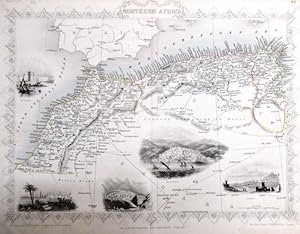
steal engraving / Grenzcolorierter Stahlstich Northern Africa. Mit weiteren 5 Bildstahlstichen 1)Mogador. 2) Marocco. 3) Constantine. 4) Algiers. 5)Tunis.
Language: English
Published by The London Printing and Publishing Company. o.J. [ca 1850], 1850
Seller: Antiquariat Carl Wegner, Berlin, B, Germany
Association Member: GIAQ
Seller rating 5 out of 5 stars

First Edition
Softcover. Blattgr��e 27x36 cm, Stichgr��e 21 x 30 cm, mittig l�ngs gefaltet. Die Tafel mit floraler Rahmung, eingezeichneten L�ngen- und Breitengraden und Ma�stabsangabe. Das Blatt an den R�ndern und in der Querfalte leicht lichtrandig und fingerfleckig, an der linken unteren Ecke eine Faltstelle, sonst sch�nes Exemplar. --- In english language. Good condition. Die Tafel beschriftet mit der Ziffer 61. Wahrscheinlich die entsprechende Tafel aus dem Werk von John Tallis: Illustrated atlas and modern history of the world. -- Zu dekorativen Zwecken, zum Rahmen geeignet. Weitere Karten aus dem gleichen Werk vorhanden. "John Rapkin was a mapmaker who was concerned with the aesthetic value of his work as well as cartographic content. His fine maps are distinguished by the trademark decorative borders, vignettes and title displays. Rapkin worked in close association with the equally respected publisher John Tallis. The publishing rights of many of the maps passed to The London Printing and Publishing Company circa 1850. " -- Bitte Portokosten au�erhalb EU erfragen! / Please ask for postage costs outside EU! / S ' il vous plait demander des frais de port en dehors de l ' UE! // Bitte beachten Sie auch unsere Fotos! / Please also note our photos! / Veuillez noter nos photos -- Genie�en Sie den Jahresanfang mit unterhaltender Lekt�re! - Bei uns finden Sie das richtige Geschenk! -- Wir kaufen Ihre werthaltigen B�cher! GM25-502030.
-
Independent Tartary [Antique Map]
Language: English
Published by The London Printing and Publishing Company, London, 1855
Seller: Books & Bidders, Cleveland, OH, U.S.A.
Association Member: IOBA
Seller rating 5 out of 5 stars
Map
No Binding. Condition: Very Good. [Map]. Original steel engraved map with decorative boarder and vignettes. Map size with central vertical fold is approx. 11 x 14 inches. Antique map of "Independent Tartary" N.D. (no date, circa 1855). Vignettes of Tartars on a Journey, The Bride Chase, and The Tent. Map scale in British miles. Map drawn and engraved by J. Rapkin, with illustrations by W. Bragg and engraved by J. Rogers. Contemporary pen outlining in color. By 1865 Tallis was among the last of the publishers of beautifully decorated hand engraved maps. Shows some expected page toning and light wear at corners.
-

Love & Anger : Good Relationships Are on a Collision Course
Language: English
Published by CreateSpace Independent Publishing Platform, 2015
ISBN 10: 1508914028 ISBN 13: 9781508914020
Seller: GreatBookPricesUK, Woodford Green, United Kingdom
Seller rating 5 out of 5 stars
US$ 20.14
US$ 20.04 shipping
Ships from United Kingdom to U.S.A.Quantity: Over 20 available
Add to basketCondition: As New. Unread book in perfect condition.
-

Love & Anger : Good Relationships Are on a Collision Course
Language: English
Published by CreateSpace Independent Publishing Platform, 2015
ISBN 10: 1508914028 ISBN 13: 9781508914020
Seller: GreatBookPricesUK, Woodford Green, United Kingdom
Seller rating 5 out of 5 stars
US$ 20.93
US$ 20.04 shipping
Ships from United Kingdom to U.S.A.Quantity: Over 20 available
Add to basketCondition: New.
-

Africa (map of)
Published by London Printing and Publishing Company, London, 1860
Seller: Victoria Bookshop, BERE ALSTON, DEVON, United Kingdom
Seller rating 4 out of 5 stars

US$ 24.12
US$ 13.16 shipping
Ships from United Kingdom to U.S.A.Quantity: 1 available
Add to basketPaperback. Condition: G-. First Thus. Minor splits to top and tail edges, this map has been folded Minor foxing. Decorative Black & White 19th century map for the Image Size: 350 x 245mm, 13.75 x 9.75" approx. Paper Size: 390 x 285mm, 15.25 x 11.25" approx. John Rapkin (fl. 1835-65) A nineteenth century map maker and engraver, best known for his work on the Illustrated Atlas of the World 1849-53 for John Tallis and Co. noted for their beautifully decorative borders and later re-issued by the London Printing and Publishing Co. London and New York. Book.
-
New Zealand [Antique Map]
Language: English
Published by John Tallis, London, 1851
Seller: Books & Bidders, Cleveland, OH, U.S.A.
Association Member: IOBA
Seller rating 5 out of 5 stars
Map
No Binding. Condition: Good. [New Zealand Map]. Original steel engraved map with decorative boarder and vignettes. Map size with central vertical fold is 14 x 11 inches. Antique map of "New Zealand" by John Tallis & Company, circa 1851. Vignettes of Auckland, Mount Egmont from New Plymouth, Wellington, and Indigenous person. Map drawn and engraved by John Rapkin, with illustrations by H. Warren and engraved by J.B. Allen. Contemporary pen outlining in color and pale blue coastline wash. By 1865 Tallis was among the last of the publishers of beautifully decorated hand engraved maps. Trimmed at top and bottom, with some light expected page toning.
-
Switzerland (map of)
Published by London Printing and Publishing Company, London, 1860
Seller: Victoria Bookshop, BERE ALSTON, DEVON, United Kingdom
Seller rating 4 out of 5 stars
US$ 34.95
US$ 13.16 shipping
Ships from United Kingdom to U.S.A.Quantity: 1 available
Add to basketPaperback. Condition: G-. First Thus. Minor splits to tail edge, this map has been folded. Very minor foxing. Decorative Black & White 19th century map for the Image Size: 350 x 245mm, 13.75 x 9.75" approx. Paper Size: 390 x 285mm, 15.25 x 11.25" approx. John Rapkin (fl. 1835-65) A nineteenth century map maker and engraver, best known for his work on the Illustrated Atlas of the World 1849-53 for John Tallis and Co. noted for their beautifully decorative borders and later re-issued by the London Printing and Publishing Co. London and New York. Book.
-
The World on Mercator's Projection (map of)
Published by London Printing and Publishing Company, London, 1860
Seller: Victoria Bookshop, BERE ALSTON, DEVON, United Kingdom
Seller rating 4 out of 5 stars
US$ 34.95
US$ 13.16 shipping
Ships from United Kingdom to U.S.A.Quantity: 1 available
Add to basketPaperback. Condition: G-. First Thus. Minor creasing and a number of splits/1 long closed tear to tail edge. nick to RH side edge with small loss. this map has been folded. Very minor foxing. Decorative Black & White 19th century map for the Image Size: 350 x 245mm, 13.75 x 9.75" approx. Paper Size: 390 x 285mm, 15.25 x 11.25" approx. John Rapkin (fl. 1835-65) A nineteenth century map maker and engraver, best known for his work on the Illustrated Atlas of the World 1849-53 for John Tallis and Co. noted for their beautifully decorative borders and later re-issued by the London Printing and Publishing Co. London and New York. Book.
-
Holland, antique map with vignette views
Published by John Tallis & Co., London, 1854
Seller: Antipodean Books, Maps & Prints, ABAA, Garrison, NY, U.S.A.
Association Member: ABAA ANZAAB ESA ILAB
Seller rating 5 out of 5 stars
Maps. Steel engraved map from the famous Victorian publisher John Tallis, well-known for the attractive vignette views surrounding the maps, which illustrate the peoples & customs of the region. 9 3/4 x 13 1/2" plus margins. Attractive decorative border around edge, very good condition.
-
Turkey in Europe, antique map with vignette views
Published by John Tallis & Co., London, 1854
Seller: Antipodean Books, Maps & Prints, ABAA, Garrison, NY, U.S.A.
Association Member: ABAA ANZAAB ESA ILAB
Seller rating 5 out of 5 stars
Maps. Steel engraved map from the famous Victorian publisher John Tallis, well-known for the attractive vignette views surrounding the maps, which illustrate the peoples & customs of the region. 12 1/2 x 10" plus margins. Attractive decorative border around edge, period outline color, very good condition.
-
Egypt, and Arabia Petr�a (map of)
Published by London Printing and Publishing Company, London, 1860
Seller: Victoria Bookshop, BERE ALSTON, DEVON, United Kingdom
Seller rating 4 out of 5 stars
US$ 39.79
US$ 13.16 shipping
Ships from United Kingdom to U.S.A.Quantity: 1 available
Add to basketPaperback. Condition: G-. First Thus. Creases, tears and minor losses to RH edge, this map has been folded Minor foxing. Decorative Black & White 19th century map for the Image Size: 350 x 245mm, 13.75 x 9.75" approx. Paper Size: 390 x 285mm, 15.25 x 11.25" approx. John Rapkin (fl. 1835-65) A nineteenth century map maker and engraver, best known for his work on the Illustrated Atlas of the World 1849-53 for John Tallis and Co. noted for their beautifully decorative borders and later re-issued by the London Printing and Publishing Co. London and New York. Book.
-
China and Burmah (map of)
Published by London Printing and Publishing Company, London, 1860
Seller: Victoria Bookshop, BERE ALSTON, DEVON, United Kingdom
Seller rating 4 out of 5 stars
US$ 39.79
US$ 13.16 shipping
Ships from United Kingdom to U.S.A.Quantity: 1 available
Add to basketPaperback. Condition: G-. First Thus. Minor creasing and a number of splits/closed tears to top and tail edges. this map has been folded. Some minor foxing. Decorative Black & White 19th century map for the Image Size: 350 x 245mm, 13.75 x 9.75" approx. Paper Size: 390 x 285mm, 15.25 x 11.25" approx. John Rapkin (fl. 1835-65) A nineteenth century map maker and engraver, best known for his work on the Illustrated Atlas of the World 1849-53 for John Tallis and Co. noted for their beautifully decorative borders and later re-issued by the London Printing and Publishing Co. London and New York. Book.
-
Russia in Europe, antique map with vignette views
Published by John Tallis & Co., London, 1854
Seller: Antipodean Books, Maps & Prints, ABAA, Garrison, NY, U.S.A.
Association Member: ABAA ANZAAB ESA ILAB
Seller rating 5 out of 5 stars
Maps. Steel engraved map from the famous Victorian publisher John Tallis, well-known for the attractive vignette views surrounding the maps, which illustrate the peoples & customs of the region. 9 1/2 x 13 1/2" plus margins. Attractive decorative border around edge, period outline color, small archival repair at center, o/w very good condition.
-
Germany, antique map with vignette views
Published by John Tallis & Co., London, 1854
Seller: Antipodean Books, Maps & Prints, ABAA, Garrison, NY, U.S.A.
Association Member: ABAA ANZAAB ESA ILAB
Seller rating 5 out of 5 stars
Maps. Steel engraved map from the famous Victorian publisher John Tallis, well-known for the attractive vignette views surrounding the maps, which illustrate the peoples & customs of the region. 9 1/2 x 13 1/2" plus margins. Attractive decorative border around edge, period outline color, very good condition.
-
Belgium, antique map with vignette views
Published by John Tallis & Co., London, 1854
Seller: Antipodean Books, Maps & Prints, ABAA, Garrison, NY, U.S.A.
Association Member: ABAA ANZAAB ESA ILAB
Seller rating 5 out of 5 stars
Maps. Steel engraved map from the famous Victorian publisher John Tallis, well-known for the attractive vignette views surrounding the maps, which illustrate the peoples & customs of the region. 12 1/2 x 10" plus margins. Attractive decorative border around edge, original hand color. Very good condition.
-
British Guayana, antique map with vignette views
Published by John Tallis & Co., London, 1854
Seller: Antipodean Books, Maps & Prints, ABAA, Garrison, NY, U.S.A.
Association Member: ABAA ANZAAB ESA ILAB
Seller rating 5 out of 5 stars
Maps. Steel engraved map from the famous Victorian publisher John Tallis, well-known for the attractive vignette views surrounding the maps, which illustrate the peoples & customs of the region. Vignettes include: Georgetown, Christmas Cataract, New Amsterdam, and Ataraipu or the Devil's Rock. 10 x 12 1/2" plus margins. Attractive decorative border around edge, period outline color, very good condition.
-
Belgium, antique map with vignette views
Published by John Tallis & Co., London, 1854
Seller: Antipodean Books, Maps & Prints, ABAA, Garrison, NY, U.S.A.
Association Member: ABAA ANZAAB ESA ILAB
Seller rating 5 out of 5 stars
Maps. Steel engraved map from the famous Victorian publisher John Tallis, well-known for the attractive vignette views surrounding the maps, which illustrate the peoples & customs of the region. 12 1/2 x 10" plus margins. Attractive decorative border around edge, original hand color. Very good condition.
-
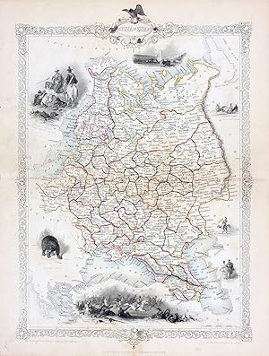
Russia in Europe, antique map with vignette views
Published by John Tallis & Co., London, 1854
Seller: Antipodean Books, Maps & Prints, ABAA, Garrison, NY, U.S.A.
Association Member: ABAA ANZAAB ESA ILAB
Seller rating 5 out of 5 stars
Maps. Steel engraved map from the famous Victorian publisher John Tallis, well-known for the attractive vignette views surrounding the maps, which illustrate the peoples & customs of the region. 9 1/2 x 13 1/2" plus margins. Attractive decorative border around edge, period outline color, very good condition.
-
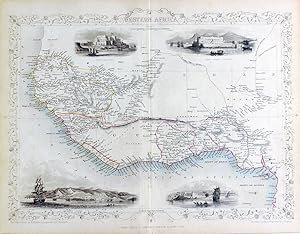
Western Africa, antique map with vignette views
Published by John Tallis & Co., London, 1854
Seller: Antipodean Books, Maps & Prints, ABAA, Garrison, NY, U.S.A.
Association Member: ABAA ANZAAB ESA ILAB
Seller rating 5 out of 5 stars
Maps. Steel engraved map from the famous Victorian publisher John Tallis, well-known for the attractive vignette views surrounding the maps, which illustrate the peoples & customs of the region. 12 1/2 x 10" plus margins. Attractive decorative border around edge, period outline color, very good condition.
-
Carte de la Chine et de la Birmanie en couleur dessin�e et grav�e par John Rapkin en 1851 pour Illustrated Atlas of the World
Published by John Tallis and Co, 1851
Map
Couverture souple. Condition: Bon. John Rapkin (1815-1876) fut un c�l�bre dessinateur de cartes et un graveur anglais du dix neuvi�me si�cle. Cette Carte de la Chine et de la Birmanie provient du c�l�bre atlas anglais "Illustrated Atlas of the World" publi� en 1851 par John Tallis and Co . Cet �diteur �tait tr�s appr�ci�e pour les d�tails g�ographiques actualis�es de ses cartes et les bordures d�coratives finement grav�es. Dimensions Largeur 33cm (36cm avec marges), Hauteur 26 cm (28 cm avec marges). La gravure est en couleur et en bon �tat � part la marge de droite qui est r�duite et irr�guli�re.
-
Northern Italy, antique map with vignette views
Published by John Tallis & Co., London, 1854
Seller: Antipodean Books, Maps & Prints, ABAA, Garrison, NY, U.S.A.
Association Member: ABAA ANZAAB ESA ILAB
Seller rating 5 out of 5 stars
Maps. Map of Northern Italy ending in Naples and including Corsica. Steel engraved map from the famous Victorian publisher John Tallis, well-known for the attractive vignette views surrounding the maps, which illustrate the peoples & customs of that region. 10 x 13 1/2" plus margins. Attractive decorative border around edge, period outline color, very good condition.
-
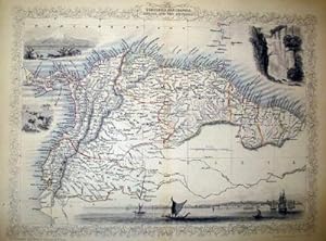
Venezuela, New Granada, Equador, and The Guayanas, antique map with vignette views
Published by John Tallis & Co., London, 1854
Seller: Antipodean Books, Maps & Prints, ABAA, Garrison, NY, U.S.A.
Association Member: ABAA ANZAAB ESA ILAB
Seller rating 5 out of 5 stars
Maps. Steel engraved map from the famous Victorian publisher John Tallis, well-known for the attractive vignette views surrounding the maps, which illustrate the peoples & customs of that region. 10 x 13 1/2" plus margins. Attractive decorative border around edge, period outline color, very good condition.
-
France, antique map with vignette views
Published by John Tallis & Co., London, 1854
Seller: Antipodean Books, Maps & Prints, ABAA, Garrison, NY, U.S.A.
Association Member: ABAA ANZAAB ESA ILAB
Seller rating 5 out of 5 stars
Maps. Steel engraved map from the famous Victorian publisher John Tallis, well-known for the attractive vignette views surrounding the maps, which illustrate the peoples & customs of the region. 12 1/2 x 10" plus margins. Attractive decorative border around edge, period outline color, sml. split at bottom of fold, o/w very good condition.
-
France, antique map with vignette views
Published by John Tallis & Co., London, 1854
Seller: Antipodean Books, Maps & Prints, ABAA, Garrison, NY, U.S.A.
Association Member: ABAA ANZAAB ESA ILAB
Seller rating 5 out of 5 stars
Maps. Steel engraved map from the famous Victorian publisher John Tallis, well-known for the attractive vignette views surrounding the maps, which illustrate the peoples & customs of the region. 12 1/2 x 10" plus margins. Attractive decorative border around edge, period outline color, dusty on vignettes, o/w good condition.
-
Cabool, the Punjab and Beloochistan, antique map with vignette views
Published by John Tallis & Co., London, 1854
Seller: Antipodean Books, Maps & Prints, ABAA, Garrison, NY, U.S.A.
Association Member: ABAA ANZAAB ESA ILAB
Seller rating 5 out of 5 stars
Maps. Map of modern Afghanistan, Pakistan, and a portion of North-West India. Steel engraved map from the famous Victorian publisher John Tallis, well-known for the attractive vignette views surrounding the maps, which illustrate the peoples & customs of that region. 10 x 13 1/2" plus margins. Attractive decorative border around edge, period outline color, very good condition.
-
Chili and La Plata, antique map with vignette views
Published by John Tallis & Co., London, 1854
Seller: Antipodean Books, Maps & Prints, ABAA, Garrison, NY, U.S.A.
Association Member: ABAA ANZAAB ESA ILAB
Seller rating 5 out of 5 stars
Maps. Map of Chile with vignettes of travelling post, the Gobernador, the Grand Square of Buenos Ayres, Water Seller of Buenos Ayres and Rattlesnake. Steel engraved map from the famous Victorian publisher John Tallis, well-known for the attractive vignette views surrounding the maps, which illustrate the peoples & customs of that region. 10 x 13 1/2" plus margins. Attractive decorative border around edge, period outline color, very good condition.
-
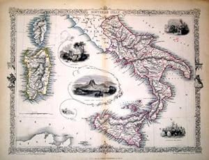
Southern Italy, antique map with vignette views
Published by John Tallis & Co., London, 1854
Seller: Antipodean Books, Maps & Prints, ABAA, Garrison, NY, U.S.A.
Association Member: ABAA ANZAAB ESA ILAB
Seller rating 5 out of 5 stars
Maps. Map of Southern Italy from Rome down and including Corsica, Sardinia, and Sicily. Steel engraved map from the famous Victorian publisher John Tallis, well-known for the attractive vignette views surrounding the maps, which illustrate the peoples & customs of that region. 10 x 13 1/2" plus margins. Attractive decorative border around edge, period outline color, very good condition.
-
Venezuela, New Granada, Equador, and The Guayanas, antique map with vignette views
Published by John Tallis & Co., London, 1854
Seller: Antipodean Books, Maps & Prints, ABAA, Garrison, NY, U.S.A.
Association Member: ABAA ANZAAB ESA ILAB
Seller rating 5 out of 5 stars
Maps. Steel engraved map from the famous Victorian publisher John Tallis, well-known for the attractive vignette views surrounding the maps, which illustrate the peoples & customs of that region. 10 x 13 1/2" plus margins. Attractive decorative border around edge, period outline color, very good condition.
![Seller image for Independent Tartary [Antique Map] for sale by Books & Bidders](https://pictures.abebooks.com/inventory/md/md31800635682.jpg)

![Seller image for New Zealand [Antique Map] for sale by Books & Bidders](https://pictures.abebooks.com/inventory/md/md31800637588.jpg)
