Order Total (1 Item Items):
Shipping Destination:

Ratzer Bernard (3 results)
Skip to main search results
Search filters
Product Type
- All Product Types
- Books (1)
- Magazines & Periodicals (No further results match this refinement)
- Comics (No further results match this refinement)
- Sheet Music (No further results match this refinement)
- Art, Prints & Posters (No further results match this refinement)
- Photographs (No further results match this refinement)
- Maps (2)
- Manuscripts & Paper Collectibles (No further results match this refinement)
Condition Learn more
- New (No further results match this refinement)
- As New, Fine or Near Fine (No further results match this refinement)
- Very Good or Good (1)
- Fair or Poor (No further results match this refinement)
- As Described (2)
Binding
- All Bindings
- Hardcover (No further results match this refinement)
- Softcover (No further results match this refinement)
Collectible Attributes
- First Edition (1)
- Signed (No further results match this refinement)
- Dust Jacket (No further results match this refinement)
- Seller-Supplied Images (3)
- Not Print on Demand (3)
Language (1)
Price
- Any Price
- Under US$ 25 (No further results match this refinement)
- US$ 25 to US$ 50 (No further results match this refinement)
- Over US$ 50
Free Shipping
Seller Location
Seller Rating
-
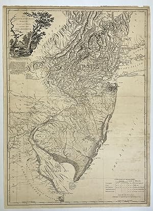
The Province of New Jersey, Divided into East and West, commonly called the Jerseys
Published by Wm. Faden, London, 1777
Seller: Donald A. Heald Rare Books (ABAA), New York, NY, U.S.A.
Seller rating 5 out of 5 stars

Map
Copper-engraved map, with original outline colour, on two joined sheets, in very good condition. The first state of one of the finest and most celebrated maps of New Jersey, made during the Revolutionary War. This elegant composition depicts New Jersey in finely engraved detail at a large scale of 7 miles to an inch. The map was the grandest representation of the state made up to that time, taking in the entire breadth of the state, as well as the Hudson Valley, most of Long Island, eastern Pennsylvania and all of Delaware Bay. It captures the state's rich topography, including the Jersey Highlands and the Palisades in the north and the broad Pine Barrens and coastal marshes in the south. The county divisions, major roads and towns are all carefully depicted, indicating that New Jersey was, by the standards of the time, heavily populated, having over 120,000 inhabitants. Faden based his rendering of the state largely on the manuscript works of Bernard Ratzer, a British military surveyor most famous for his map of New York City. Ratzer's rendezvous with New Jersey cartography stemmed from the resolution of the bitter boundary dispute between that state and New York that had raged for over a century. In 1764, George III charged Samuel Holland and William De Brahm with settling the boundary, and their demarcation was finally surveyed by Ratzer in 1769. Ratzer's line is noted on the map as "The boundary settled by commissioners in 1769". Two of Ratzer's New Jersey manuscripts, one dealing with the boundary question, and another featuring Monmouth and Ocean Counties are today preserved in the Faden Collection at the Library of Congress. Faden supplemented Ratzer's work with surveys of the northern part of the state made by Gerard Bancker. Curiously, it seems that Bancker's work found its way to Faden, by way of John Murray, the Earl of Dunmore, the former governor of Virginia, who was given a draft by Bancker when he stopped in at New York on his way back to London. An interesting feature present on the map are the two lines bisecting the state, being the boundary lines between the archaic colonies of East and West Jersey. In 1664, Charles II granted the New Jersey charter jointly to Lord Berkeley and Sir George Carteret. Berkeley sold his share to John Fenwick, a Quaker who, in turn, passed it on to a consortium that included William Penn. The king elected to renew only Carteret's charter to the colony, and from 1676 the already small province was split into two awkward colonies. One of the lines present on this map is "Keith's Line" referring to the 1687 demarcation of the boundary by surveyor George Keith. While the two colonies were reunited under a royal governor in 1702, certain private land ownership questions predicated on the partition necessitated that an internal line of division persist, which was re-demarcated as the "Lawrence Line" in 1743. The map is embellished with a very fine cartouche, formed by trees framing a bucolic scene inhabited by farm houses and raccoons. The lower left of the map is adorned with a table of astrological observations. This copy is an excellent example of this important map, featuring a strong impression and good margins. In a careful original hand, New Jersey, and its internal boundaries have been outlined in pink, while surrounding jurisdictions are outlined in a yellow-green hue. Guthorn, British Maps of the American Revolution, p.39; Degrees of Latitude, 47; Schwartz & Ehrenberg, Mapping of America, p.193; Snyder, The Mapping of New Jersey, pp.57-59.
-
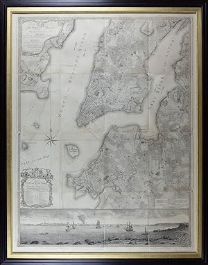
Plan of the City of New York in North America: Surveyed in the Years 1766 & 1767
Published by Jefferys & Faden, London, 1776
Map First Edition
No binding. Condition: Very good. First. First edition, second state. London: Jefferys & Faden, Jan.y 12, 1776. Etched-engraved map on three sheets joined, folded to make 16 compartments (map: 48 5/8" x 35 3/4", 1235mm x 908mm; frame: 54 1/2" x 42 1/4", 1384mm x 1080mm). Framed floating. Joined and dissected, laid down on washi paper. With losses at each join, as well as some losses around the extremities of the joined map. Even mild tanning, with some foxing to the compartment at the upper edge, just right of center. Recently conserved: delaminated from old linen, re-joined and washed. Bernard (Bernhard) Ratzer is known principally through his cartographic output: maps of the east coast of America, ranging from 1756 (Passamaquoddy Bay, just over the modern border of Canada from Maine; a manuscript map at the Huntington, mssHM 15417) through 1782 (a French edition of his map of New Jersey). In the dedication of the present map, he identifies himself as "Lieut.t in His Majestys 60.th or Royal American Reg.t" and Cumming, citing the List of the General and Field Officers, bears this out; he was commissioned a lieutenant on 20 February 1756 and promoted captain lieutenant in 1773. His name suggests a German origin, but in the absence of additional information he remains more a name than a person. The map was forged in the early flames of the Revolution. After the Stamp Act Riots of 1765, the royal governor, Sir Henry Moore, ordered that the City -- then settled more or less up to modern 59th St. -- be completely resurveyed; the task fell to Ratzer. The result was the "Ratzen Plan," published in 1766 but with the cartographer's name misspelled as "Ratzen." Never has a cartographer been more slighted; Ratzer's map was immeasurably superior to those that predated it, not only for its accuracy but also for its completeness. As soon as 1767 Ratzer worked to update and to augment his first effort; the expanded map (published in 1770, and commonly called the "Ratzer Map") now featured a "South West View of the City of New York from Governours Island at *" (with the * indicating the precise point from which the view was taken) drawn by Lt. Thomas Davies. Parcel-holders' names, small winding streets and the complex profile of the coasts are all faithfully rendered. The soundings throughout the harbor and rivers remind us that this is essentially a military map: a bulwark against the seemingly-inevitable conflict between the Colonists and the Colonizers. The 1770 map -- the whole engraved by the great Thomas Kitchin, hydrographer to the King -- is now quite rare indeed, with only a few examples known to survive. The impending War of Independence made access to the map more urgent; the London firm of Jefferys & Faden re-issued the map (the only difference being the imprint just above the view; Ratzer's promotions in the intervening years are not recorded, leaving him a lowly lieutenant). The map seems to have circulated widely among officers on both sides. Dissection such as in the present example allowed for the map to be folded up small enough to fit in an officer's holster bag; the lower half of General Hugh Percy's example, used at the Battle of Brooklyn, is in the collection of the Center for Brooklyn History at the Brooklyn Public Library (formerly the Brooklyn Historical Society). Purchased at Doyle, 29 April 2021, lot 1032. Cumming, William P. "The Montresor-Ratzer-Sauthier Sequence of Maps of New York City, 1766-76." Imago Mundi 31 (1979): 55-65; 9b. Augustyn & Cohen, Manhattan in Maps pp. 73-77; De�k, Picturing America 121; Pritchard & Taliaferro, Degrees of Latitude 46; Schwartz/Ehrenberg, The Mapping of America p. 192; Stokes, Iconography p. 341.
-
Province of New Jersey, Divided into East And West, Commonly Called
Publication Date: 1778
Seller: G.S. MacManus Co., ABAA, Bryn Mawr, PA, U.S.A.
Seller rating 5 out of 5 stars
FADEN, William, and RATZER, Bernard. The Province of New Jersey, Divided into East And West, Commonly Called Called The Jerseys. London: Wm. Faden, December 1, 1778. 2nd ed. with Considerable Improvements. Copper-engraved map on two joined sheets, 32 x 24 inches in total, with original outline color. Guthorn, British Maps of the American Revolution, p.39. Degrees of Latitude 47. Schwartz & Ehrenberg, p.193. Snyder, The Mapping of New Jersey, pp.57-59. This elegant composition depicts New Jersey in finely engraved detail at a large scale of seven miles to an inch. The map was the grandest representation of the state made up to that time, taking in the entire breadth of the state, as well as the Hudson Valley, most of Long Island, eastern Pennsylvania, and all of Delaware Bay. It captures the state's rich topography, including the Jersey Highlands and the Palisades in the north and the broad Pine Barrens and coastal marshes in the south. The county divisions, major roads and towns are all carefully depicted, indicating that New Jersey was, by the standards of the time, heavily populated, having over 120,000 inhabitants. "In this Second Edition great use has been made of several Military Surveys generously Communicated by Officers of the British Troops and of the Regiments of Hesse and Anspach." Faden based his rendering of the state largely on the manuscript works of Bernard Ratzer, a British military surveyor most famous for his map of New York City. Ratzer's rendezvous with New Jersey cartography stemmed from the resolution of the bitter boundary dispute between that state and New York that had raged for over a century. In 1764, George III charged Samuel Holland and Willian De Brahm with settling the boundary, and their demarcation was finally surveyed by Ratzer in 1769. Ratzer's line is noted on the map as "The boundary settled by commissioners in 1769." Two of Ratzer's New Jersey manuscripts, one dealing with the boundary question, and another featuring Monmouth and Ocean Counties are today preserved in the Faden Collection at the Library of Congress. Faden supplemented Ratzer's work with surveys of the northern part of the state made by Gerard Bancker. Curiously, it seems that Bancker's work found its way to Faden, by way of John Murray, the Earl of Dunmore, the former governor of Virginia, who was given a draft.