Sanson Nicholas (53 results)

Published by Chez L'Autheur 1667
- Hardcover
Seller: Arader Galleries - AraderNYC, New York, NY, U.S.A.Arader Galleries - AraderNYC
Contact seller5-star sellerCondition: Used - Very good
US$ 14,000.00
Free ShippingShips within U.S.A.Quantity: 1 available
Hardcover. Condition: Very Good. Paris: Chez L'Autheur, [1667]. Quarto (9 5/8" x 7", 245mm x 178mm). With 16 double-page engraved maps. Bound in contemporary calf with gilt decoration and five raised bands on the spine. All maps mounted on guards with original hand-colour in outline, and with engraved colophon "Chez Pierre Marie…tte Rue St. Jacques a L'Esperence". Extremities worn, front cover starting at head and foot of spine. Rear hinge worn. Foxing and staining throughout. THE FIRST FRENCH ATLAS OF AMERICA. Nicholas Sanson D'Abbeville (1600-1667) was a French cartographer of Scottish descent, born in Abbeville in northern France. He served two kings, Louis XIII and Louid XIV, and was considered the premiere French cartographer of his time. Sanson published his first folio atlas in 1654 with 100 maps, engraved and printed by Pierre Mariette. Sanson's series of quarto atlases were originally published separately as "L'Europe" in 1648 by Sanson's son, also Nicholas, who was tragically killed in the "Barricades" insurrection the same year, "L'Asie" in 1652, "L'Afrique" in 1656, and "L'Amerique" in 1657. This atlas contains maps of Amerique Septentrionale, Isle d'Islande (1667), Le Canada, ou Nouvelle France, la Floride, Mexico, Guadalajara, Guatimala, Les Ilses Antilles, Amerique Meridionale, Terre Ferme. de Grenade, Guiane, Le Perou, Le Chilli, Le Bresil, Le Paraguay, and Detroit de Magellan. Sanson was known for supplying the most accurate geographic information and finest engraving, inititing the preeminent "French school of cartography". His "Cartes Generales de Toutes les Parties du Monde"was the most significant example of French cartography of the seventeenth century. Sabin 76708.
Published by Pierre Mariette 1665
- Hardcover
Seller: Arader Galleries - AraderNYC, New York, NY, U.S.A.Arader Galleries - AraderNYC
Contact seller5-star sellerCondition: Used - Very good
US$ 245,000.00
Free ShippingShips within U.S.A.Quantity: 1 available
Hardcover. Condition: Very Good. Paris: Pierre Mariette, 1665. Folio (17 2/8 x 12 6/8 inches). Title-page with woodcut device, 2-page letterpress list of maps, and two appendices only: Sanson's 'Table alphabetique de toutes les villes . dans la carte d'Italie' (38 pages) and 'Table alphabetique de toutes les villes dans la carte… du Rein', Paris: 1646 (12 double-pages, blank on verso). 134 double-page engraved maps by Pierre Mariette after Sanson (of a possible 171 listed by Pastoureau), EXTRA-ILLUSTRATED with a further 62 maps after Sanson and other French and Dutch cartographers, including P. du Val, P. de la Rue, C. Danckerts, J. Jansson, and J. and H. Hondius, all double-page and in a few cases folding, usually hand-coloured in outline, mounted on guards and continuously numbered in manuscript up to 195, including 46 bis (map of Paraguay heavily stained at upper margin, that of southern South America restored with loss to sea area, a few small repairs elsewhere, map of Corsica and Sardinia slightly waterstained, marginal waterstaining affecting several other maps, some browning to additional maps and occasional shaving of borders, lower corners curling slightly through most of the volume). 18th-century English half calf and blue marbled paper boards (joints cracked, extremities rubbed). Provenance: extensive contemporary manuscript alterations to map list, manuscript numbering; 4-page manuscript 'Table des Cartes' in an 18th-century hand; Foljambe Collection removed from Osberton Hall, with the discreet woodcut library stamp of Francis Ferrand Foljambe (1749 - 1814) at the foot of the title-page, and the foot of the binding, his sale 30th April 2008, lot 99. The maps were compiled by Nicolas Sanson who first published his atlas in 1654, with 100 maps, and engraved and printed by Pierre Mariette; each held the copyright to half of the maps which bear their separate imprints, and were issued progressively from 1630. The maps in this Atlas date from 1632 "Carte Geographique des Postes qui traversent la France" by Melchior Tavernier, but are evenly dated from the 1640s to 1667. They include the latest discoveries in the New World. 'Amerique sepentrionale', dated 1650, shows the Great Lakes for the first time; these also appear in the 1656 map of Canada. The map of New Mexico and Florida, also 1656, introduced California as an island. South America is mapped in great detail, and a double hemisphere map is devoted to the two poles. The 'Table des Cartes' calls for a total of 166 maps, 134-166 being maps of the ancient world which were clearly never bound into this copy. The extra-illustrated maps can be identified by their slightly smaller size, and not only include additional maps by Sanson but, more unusually, a significant contribution by other cartographers. Born in Abbeville, a town in the Picardy region of France, in 1600, Sanson was the most noted French cartographer in modern history. Mapmaker to Louis XIV, King of France, Sanson endowed his maps with the most recent geographical information as well as the finest and sharpest engraving of the period. His "Cartes Generales de Toutes les Parties du Monde" was the most important single product of French commercial cartography of the seventeenth century. Sanson sparked a renaissance in geographical endeavor in his native country, which had not been a major player since the sixteenth century. With this atlas, Sanson helped move the center of cartographic innovation from Holland to France.
Published by Paris: Sanson and Pierre Mariette, 1658 [but 1659]. 1659
- Hardcover
Seller: Arader Galleries - AraderNYC, New York, NY, U.S.A.Arader Galleries - AraderNYC
Contact seller5-star sellerHardcover. Folio. (17 x 12 6/8 inches). Title-page with woodcut arms, letterpress table of contents (very creased). 114 FINE engraved double-page maps, including 2 folding, hand-coloured in outline, mounted on guards throughout (one or two pale marginal). Contemporary mottled calf, spine in seven compartments with six raised ban…ds, title gilt-lettered in one, the others decorated with small gilt tools (scuffed and worn with loss to extremities). A fine composite atlas, including four double-hemisphere world maps: "Mappe-Monde, ou Carte Generale du Monde" 1651, "L'Hydrographie ou Description de l'Eau" 1652, "Harmonie ou Correspondance du Globe." 1659, and "Orbis Vetus" 1657, each showing California as an island and a partial coastline of Australia with the "Beach" peninsula; and the fine map "Les Deux Poles Arctique." 1657 showing Canada, and "Australe Incogneue". Maps relating to America include the world maps and "Amerique Septentrionale" 1650 the first to show all five Great Lakes, "Le Canada, ou Nouvelle France" 1656, "Le Nouveau Mexique, et la Floride" 1656, "Mexique ou Nouvelle Espagne" 1650, "Les Isles Antilles" 1656, "Amerique Meridionale" 1650, "Terre Ferme" 1656, "Partie de Terre Ferme ou font Guine et Caribane" 1656, "Le Perou" 1656, "Le Chili" 1656, "Le Bresil" 1656, and "Le Paraguyr, Le Chili, La Terre, et Les Isles Magellanicques" 1656. Maps related to Australia are: "Asie" 1650, "Asia Vetus" 1650, and "Les Isles Philippines Molucques et de la Sonde" 1654 each show the west coast of Carpentaria. The maps were compiled by Nicolas Sanson who first published his atlas in 1654, with 100 maps, and engraved and printed by Pierre Mariette; each held the copyright to half of the maps which bear their separate imprints, and were issued progressively from 1630. The maps in this Atlas date from 1632 "Carte Geographique des Postes qui traversent la France" by Melchior Tavernier, but are evenly dated from the 1650s. Born in Abbeville, a town in the Picardy region of France, in 1600, Sanson was the most noted French cartographer in modern history. Mapmaker to Louis XIV, King of France, Sanson endowed his maps with the most recent geographical information as well as the finest and sharpest engraving of the period. His "Cartes Generales de Toutes les Parties du Monde" was the most important single product of French commercial cartography of the seventeenth century. Sanson sparked a renaissance in geographical endeavor in his native country, which had not been a major player on the international cartographic stage since the great Oronce Finé in the sixteenth century. With this atlas, Sanson laid the foundations of French domination in map production, initiating the so-called "French school of cartography," a school that was unprecedented in its attention to precision and scientific detail and discarded much of the decorative embellishments of previous maps as irrelevant. From Sanson's time in the second half of the seventeenth century until the latter part of the eighteenth century, French geographical conceptions were more influential than those put forward by any other nation. With this landmark atlas, Sanson all but single-handedly caused the center of cartographic innovation to shift from Holland to France. Lloyd Arnold Brown, The World Encompassed, exh. cat. (Baltimore, 1952), n. 157; Rodney W. Shirley, The Mapping of the World (London, 1983), n. 390; Philip D. Burden, The Mapping of North America: A List of Printed Maps 1511-1670 (Rickmansworth, 1996), 375-6. Catalogued by Kate Hunter.
Published by Paris: The Author and Pierre Mariette, 1658 [but 1659]. 1659
- Hardcover
Seller: Arader Galleries - AraderNYC, New York, NY, U.S.A.Arader Galleries - AraderNYC
Contact seller5-star sellerCondition: Used - Very good
US$ 85,000.00
Free ShippingShips within U.S.A.Quantity: 1 available
Hardcover. Condition: Very Good. Folio (17 x 12 4/8 inches). Title-page with woodcut arms, letterpress table of contents. 113 fine double-page engraved maps with beautiful original colour in outline (map of Germania Antiqua waterstained at outer edge just affecting image). 19th-century quarter French sheep, marbled paper boards…(extremities scuffed). Provenance: contemporary consecutive numbering to the versos of most maps. Those maps relating particularly to the Americas are: three world maps "Mappe-Monde." 1651 one of the earliest obtainable maps to show the 5 Great Lakes, "l'Hydrographie ou description de l'Eau" 1652, "Harmonie ou Correspondance du Globe." 1650, "Orbis vetus, et orbis vetris." 1657 (each map showing California as an island and the "Beach" peninsula, "Amerique Septentrionale" 1650, "Le Canada, ou Nouvelle France." 1656, Mexique ou Nouvelle Espagne" 1650, "Le Nouvelle Mexique, et la Floride" 1656, "Les Ilse Antilles ." 1656, "Amerique Meridionale" 1650, "Terre Ferme" 1656, ".Guinane et Caribane." 1656, "Le Perou" 1656, "Le Chili" 1656, "Le Bresi" 1656, "Le Paraguayr, Le Chili, La Terre, et les Isles Magellanicques" 1656, "Les deux Poles" 1657. The maps were compiled by Nicolas Sanson who first published his atlas in 1654, with 100 maps, and engraved and printed by Pierre Mariette; each held the copyright to half of the maps which bear their separate imprints, and were issued progressively from 1630. Born in Abbeville, a town in the Picardy region of France, in 1600, Sanson was the most noted French cartographer in modern history. Mapmaker to Louis XIV, King of France, Sanson endowed his maps with the most recent geographical information as well as the finest and sharpest engraving of the period. His "Cartes Generales de Toutes les Parties du Monde" was the most important single product of French commercial cartography of the seventeenth century. Sanson sparked a renaissance in geographical endeavor in his native country, which had not been a major player on the international cartographic stage since the great Oronce Finé in the sixteenth century. With this atlas, Sanson laid the foundations of French domination in map production, initiating the so-called "French school of cartography," a school that was unprecedented in its attention to precision and scientific detail and discarded much of the decorative embellishments of previous maps as irrelevant. From Sanson's time in the second half of the seventeenth century until the latter part of the eighteenth century, French geographical conceptions were more influential than those put forward by any other nation. With this landmark atlas, Sanson all but single-handedly caused the center of cartographic innovation to shift from Holland to France. Phillips 4260 NMM 3, 271. Catalogued by Kate Hunter.
 More images
Published by Paris: The Author and Pierre Mariette, 1658 [but 1659]. 1659
- Hardcover
Seller: Arader Galleries - AraderNYC, New York, NY, U.S.A.Arader Galleries - AraderNYC
Contact seller5-star sellerHardcover. Folio. (17 x 11 6/8 inches). Title-page with woodcut arms (dampstained), 3-page contemporary manuscript "Repertoir des Cartes de ce livre" (without letterpress table of contents). 85 FINE engraved double-page maps, including 10 folding, hand-coloured in outline, mounted on guards throughout (one or two early repairs,…tears, stains and edges frayed to folding map of Gascony, last map of Ancient Greece stained and laid down on contemporary stock). Contemporary mottled calf, spine in seven compartments with six raised bands, morocco lettering piece in one, the others decorated with small gilt tools (scuffed and worn with loss to extremities). A fine composite atlas: the manuscript list of contents detailing the 75 maps of the modern world, including two world maps, with an additional ten maps of the old world, including one world map. With two maps of America: "Amerique Septentrionale" (1650), the first to show all five Great Lakes; and "Amerique Meridionale" 1650. The maps were compiled by Nicolas Sanson who first published his atlas in 1654, with 100 maps, and engraved and printed by Pierre Mariette; each held the copyright to half of the maps which bear their separate imprints, and were issued progressively from 1630. The maps in this Atlas date from 1632 "Carte Geographique des Postes qui traversent la France" by Melchior Tavernier, but are evenly dated from the late 1630s to 1659. Born in Abbeville, a town in the Picardy region of France, in 1600, Sanson was the most noted French cartographer in modern history. Mapmaker to Louis XIV, King of France, Sanson endowed his maps with the most recent geographical information as well as the finest and sharpest engraving of the period. His "Cartes Generales de Toutes les Parties du Monde" was the most important single product of French commercial cartography of the seventeenth century. Sanson sparked a renaissance in geographical endeavor in his native country, which had not been a major player on the international cartographic stage since the great Oronce Finé in the sixteenth century. With this atlas, Sanson laid the foundations of French domination in map production, initiating the so-called "French school of cartography," a school that was unprecedented in its attention to precision and scientific detail and discarded much of the decorative embellishments of previous maps as irrelevant. From Sanson's time in the second half of the seventeenth century until the latter part of the eighteenth century, French geographical conceptions were more influential than those put forward by any other nation. With this landmark atlas, Sanson all but single-handedly caused the center of cartographic innovation to shift from Holland to France. Lloyd Arnold Brown, The World Encompassed, exh. cat. (Baltimore, 1952), n. 157; Rodney W. Shirley, The Mapping of the World (London, 1983), n. 390; Philip D. Burden, The Mapping of North America: A List of Printed Maps 1511-1670 (Rickmansworth, 1996), 375-6. Catalogued by Kate Hunter.
Published by Paris: The Author and Pierre Mariette, 1658 [but 1665]. 1665
- Hardcover
Seller: Arader Galleries - AraderNYC, New York, NY, U.S.A.Arader Galleries - AraderNYC
Contact seller5-star sellerHardcover. Folio (17 2/8 x 12 6/8 inches). Title-page with woodcut arms (laid down on contemporary stock), letterpress "Table des Cartes" (extensively repaired on verso). Double-page engraved "Mappemonde ou carte generale" (1651) (repaired on verso with missing text supplied in manuscript), and 130 maps, all hand-colored in outl…ine and mounted on guards throughout (occasional light spotting, browning or marginal dampstaining, last map of Ancient Greece repaired on verso). Late 17th-century calf gilt (spine and corners with early restoration). Provenance: Maps numbered consecutively in a 17th-century hand. A comprehensive edition of Sanson's important work, containing a number of important maps pertaining to the Americas: "Mappemonde ou carte generale" (1651), "L'Hydrographie ou description de L'Eau" (1652), "Harmonie ou Correspondance du Globe" (1659) all showing California as an island; "Amerique Septentrionale" (1650), the first to show all five Great Lakes; "Le Canada, ou Nouvelle France" (1656); "Le Nouveau Mexique et la Floride" (1656); "Mexicque ou Nouvelle Espagne" (1656); "Les Isles Antilles." (1656); "Amerique Meridionale" (1650); "Terre Ferme ou sont les Governations, ou Gouvernemens de Terre Ferme, Cartagene, St. Marthe, Rio De la Hache, Venezuela, Nouvelle Andaluise, Popyan" (1656); "Partie de Terre Ferme ou sont Guiane et Caribane" (1656); "Le Perou et le course de la Rivre Amazone" (1656); "Le Chili" (1656); "Le Bresil" (1656); "Le Paraguayr, Le Chili, et Les Isles Magellanicques" (1656); "Les Deux Poles." (1657); and "Orbis Vetus." (1657). The maps in this Atlas date from 1632 "Carte Geographique des Postes qui traversent la France" by Melchior Tavernier through to 1665. The maps were compiled by Nicolas Sanson who first published his atlas in 1654, with 100 maps, and engraved and printed by Pierre Mariette; each held the copyright to half of the maps which bear their separate imprints, and were issued progressively from 1630. Born in Abbeville, a town in the Picardy region of France, in 1600, Sanson was the most noted French cartographer in modern history. Mapmaker to Louis XIV, King of France, Sanson endowed his maps with the most recent geographical information as well as the finest and sharpest engraving of the period. His "Cartes Generales de Toutes les Parties du Monde" was the most important single product of French commercial cartography of the seventeenth century. Sanson sparked a renaissance in geographical endeavor in his native country, which had not been a major player on the international cartographic stage since the great Oronce Finé in the sixteenth century. With this atlas, Sanson laid the foundations of French domination in map production, initiating the so-called "French school of cartography," a school that was unprecedented in its attention to precision and scientific detail and discarded much of the decorative embellishments of previous maps as irrelevant. From Sanson's time in the second half of the seventeenth century until the latter part of the eighteenth century, French geographical conceptions were more influential than those put forward by any other nation. With this landmark atlas, Sanson all but single-handedly caused the center of cartographic innovation to shift from Holland to France. The index calls for 113 titles, but as was often the case more maps have been added to this copy at the time of purchase. Cf. NMM 3, 271. Catalogued by Kate Hunter.
 More images
Language: Latin
Published by Excudit Franciscus Halma Typograph, Amsterdam 1704
- Hardcover
Seller: FOLIOS LIMITED, Oxford, United KingdomFOLIOS LIMITED
Contact seller5-star sellerCondition: Used - Good
US$ 2,485.60
US$ 46.92 shippingShips from United Kingdom to U.S.A.Quantity: 1 available
Hardcover. Condition: Good. 15 pp., Preface, [11 Animadversiones, (notes)] / Index Gepgraphicus et Explicatio Regionum, & Locorum Omnium: 111 pp., / Joannis Clerici Notae in Indicem Geographicum Nic Samsonis: 16 pp., / Judea & Jesu Christi Salvatoris Nostri Vita: 51 pp., [1], engraved title page, foxed outside the illustration b…order, 4 double-page engraved maps, of which 3 are engraved by F. Halma, the maps are the Francois Halma reissues of Sanson's maps from 1683, contemporary calf, rubbed, marked and soiled, title label on raised & gilt decorated spine, title in black and red ink, title vignette, spine extremities lightly cracked, some pages slightly browned, bookplate of John Marques of Tueeddale Earle of Gifford Viscount Walden, Lord of Hay and Yester &c. verso front cover. Nicolas Sanson 1600-1667."Born in Abbeville, a town in the Picardy region of France, in 1600, Sanson was the most noted French cartographer in modern history. Mapmaker to Louis XIV, King of France, Sanson endowed his maps with the most recent geographical information as well as the finest and sharpest engraving of the period. His "Cartes Generales de Toutes les Parties du Monde" was the most important single product of French commercial cartography of the seventeenth century. Sanson sparked a renaissance in geographical endeavor in his native country, which had not been a major player on the international cartographic stage since the great Oronce Finé in the sixteenth century. With this atlas, Sanson laid the foundations of French domination in map production, initiating the so-called "French school of cartography," a school that was unprecedented in its attention to precision and scientific detail and discarded much of the decorative embellishments of previous maps as irrelevant. From Sanson's time in the second half of the seventeenth century until the latter part of the eighteenth century, French geographical conceptions were more influential than those put forward by any other nation. With this landmark atlas, Sanson all but single-handedly caused the center of cartographic innovation to shift from Holland to France." [Pastoureau Sanson-VD; Shirley T. SAN-2b. Catalogued by Kate Hunter]. Bibliographic references: Rohricht 1129; Laor 692; Tobler 212; Furst III 244. #31734.
Published by Paris: Nicholas Sanson. 1656
- Art Print
Seller: Wittenborn Art Books, San Francisco, CA, U.S.A.Wittenborn Art Books
Contact seller5-star sellerCondition: Used - Good
US$ 125.00
US$ 10.00 shippingShips within U.S.A.Quantity: 1 available
Condition: Good. Hand colored engraving. 18.5 x 29.7 cm. (plate). Very Good, folded in center.

Published by Paris, 1656-1705. 235 x 205mm (9¼ x 8 inches). 1705
Seller: Tooley, Adams & Co., Wallingford, OXON, United KingdomTooley, Adams & Co.
Contact seller3-star sellerCondition: Used
US$ 110.47
US$ 49.81 shippingShips from United Kingdom to U.S.A.Quantity: 1 available
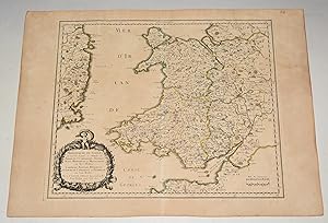
Uncoloured; light marginal age-toning and one minor nick well away from platemark, short centrefold tear repaired, otherwise good condition. A map of England and Wales, possibly engraved by A de Winter and published in the Dutch edition of the small atlas by Nicholas Sanson.

Published by Paris, 1656-1705. 200 x 285mm (7¾ x 11¼ inches). 1705
Seller: Tooley, Adams & Co., Wallingford, OXON, United KingdomTooley, Adams & Co.
Contact seller3-star sellerCondition: Used
US$ 117.38
US$ 49.81 shippingShips from United Kingdom to U.S.A.Quantity: 1 available
Uncoloured; light marginal age-toning and one minor nick well away from platemark, otherwise fine condition. A map of West Africa and the Cape Verde Islands engraved by A de Winter and published in the Dutch edition of the small atlas by Nicholas Sanson.

Published by Paris, c.1705. 180 x 290mm (7 x 11½ inches). 1700
Seller: Tooley, Adams & Co., Wallingford, OXON, United KingdomTooley, Adams & Co.
Contact seller3-star sellerCondition: Used
US$ 117.38
US$ 49.81 shippingShips from United Kingdom to U.S.A.Quantity: 1 available
Uncoloured; light marginal age-toning and one minor nick well away from platemark, otherwise fine condition. A map of West Africa and the Canary Islands, probably engraved by A de Winter and published in the Dutch edition of the small atlas by Nicholas Sanson.

Published by Paris, c.1680. 275 x 205mm (10¾ x 8 inches). 1680
Seller: Tooley, Adams & Co., Wallingford, OXON, United KingdomTooley, Adams & Co.
Contact seller3-star sellerCondition: Used
US$ 124.28
US$ 49.81 shippingShips from United Kingdom to U.S.A.Quantity: 1 available
Coloured; light age-toning and spotting to margins, overall very good condition. A map of Egypt, from Sanson's "L'Amerique en Plusiers Cartes Nouvelles", probably engraved by Antony de Winter and published 1683.
 More images
Published by PARIS Chez l?Auteur 1654. 1654
- Map
Seller: PROCTOR / THE ANTIQUE MAP & BOOKSHOP, DORCHESTER, United KingdomPROCTOR / THE ANTIQUE MAP & BOOKSHOP
Contact seller5-star sellerCondition: Used
US$ 151.90
US$ 26.81 shippingShips from United Kingdom to U.S.A.Quantity: 1 available
Title cartouche to lower left corner. Blank on verso. In good condition. Some light tanning on edges, with a few faint foxing marks. A few hole top of centre fold on map. Small neatly repair tear lower margin, and small hole top margin. With original outline hand colouring. Engraved Size 17.5 x 23 inches Nicolas Sanson (1600-166…7) sometimes called Nicolas Sanson d'Abbeville or Sanson d'Abbeville, was the most important French cartographer of the 17th century. Tooley called Sanson "the founder of the French school of cartography." He began making maps in the late 1620s, and in the 1630s he was working with Melchior Tavernier. Later, Sanson worked in concert with the print publisher Pierre Mariette, with whom he published his great atlas: Cartes générales de toutes les parties du monde (1658). After Sanson's death in 1667, his son Guillaume carried on the business in partnership with Alexis Hubert Jaillot. Guillaume established himself as a very important French mapmaker in his own right.

Published by Paris, c.1680. 200 x 275mm (7¾ x 10¾ inches). 1680
Seller: Tooley, Adams & Co., Wallingford, OXON, United KingdomTooley, Adams & Co.
Contact seller3-star sellerCondition: Used
US$ 131.18
US$ 49.81 shippingShips from United Kingdom to U.S.A.Quantity: 1 available
Coloured; light age-toning and spotting to margins, overall very good condition. A map ofGuiana, showing part of Venezuela, Guyana, Suriname, French Guiana and Amapa. Possibly engraved by Antoine de Winter for Sanson's "L'Amerique en Plusiers Cartes Nouvelles".

Published by Paris, c.1680. 195 x 245mm (7¾ x 9¾ inches). 1660
Seller: Tooley, Adams & Co., Wallingford, OXON, United KingdomTooley, Adams & Co.
Contact seller3-star sellerCondition: Used
US$ 135.33
US$ 49.81 shippingShips from United Kingdom to U.S.A.Quantity: 1 available
Coloured; light age-toning and minor water stain in margin, overall a fine example. India, with inset of Malabar shown in greater detail.

Published by Paris, c.1680. 190 x 260mm (7½ x 10¼ inches). 1652
Seller: Tooley, Adams & Co., Wallingford, OXON, United KingdomTooley, Adams & Co.
Contact seller3-star sellerCondition: Used
US$ 151.90
US$ 49.81 shippingShips from United Kingdom to U.S.A.Quantity: 1 available
Coloured; light age-toning and minor soiling to margins, overall a good example. A map of the Middle East covering; Syria, Palestine, Cyprus and Persia.

Published by Paris, c.1680. 240 x 205mm (9½ x 8 inches). 1680
Seller: Tooley, Adams & Co., Wallingford, OXON, United KingdomTooley, Adams & Co.
Contact seller3-star sellerCondition: Used
US$ 151.90
US$ 49.81 shippingShips from United Kingdom to U.S.A.Quantity: 1 available
Coloured; overall fine condition. A map of England and Wales as it was during the Saxon Heptarchy (500-850 AD), possibly engraved by Antony de Winter and published in the small atlas by Nicholas Sanson.
Published by Amsterdam: Johannes Covens and Cornelis Mortier, [ca. 1740] 1740
Seller: Arader Galleries - AraderNYC, New York, NY, U.S.A.Arader Galleries - AraderNYC
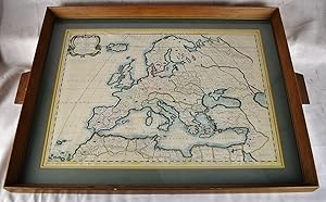
Contact seller5-star seller2 sheets joined (sheet size 21 x 24 7/8 inches; 15 3/8 x 23 3.5/8 inches to the neat line) full margins showing the plate mark. A fine engraved detailed map of Europe, the title within an elaborate and elegant cartouche upper left; original hand color in part (a little toned at the edges) An exceptional map of Europe by Covens a…nd Mortier in a splendid condition. This map was originally made by Nicholas Sanson d'Abbeville (1600-1667), the founder of the French School of Geography, a school that was unprecedented in its attention to precision and scientific detail and discarded much of the decorative embellishments of previous maps as irrelevant. Johannes Covens (1697-1774) and Cornelis Mortier (1699-1783) were the founders of the biggest cartographic publishing company of the eighteenth century.
 More images
Published by PARIS Chez l?Auteur 1654. 1654
- Map
Seller: PROCTOR / THE ANTIQUE MAP & BOOKSHOP, DORCHESTER, United KingdomPROCTOR / THE ANTIQUE MAP & BOOKSHOP
Contact seller5-star sellerCondition: Used
US$ 182.28
US$ 26.81 shippingShips from United Kingdom to U.S.A.Quantity: 1 available
Title cartouche to lower right corner. Blank on verso. In good condition. Some light tanning on edges, with a few faint foxing marks. A few small nicks lower margin edge. With original outline hand colouring. Engraved Size 17.5 x 23 inches Nicolas Sanson (1600-1667) sometimes called Nicolas Sanson d'Abbeville or Sanson d&ap…os;Abbeville, was the most important French cartographer of the 17th century. Tooley called Sanson "the founder of the French school of cartography." He began making maps in the late 1620s, and in the 1630s he was working with Melchior Tavernier. Later, Sanson worked in concert with the print publisher Pierre Mariette, with whom he published his great atlas: Cartes générales de toutes les parties du monde (1658). After Sanson's death in 1667, his son Guillaume carried on the business in partnership with Alexis Hubert Jaillot. Guillaume established himself as a very important French mapmaker in his own right.
 More images
Published by PARIS Chez l?Auteur 1654. 1654
Seller: PROCTOR / THE ANTIQUE MAP & BOOKSHOP, DORCHESTER, United KingdomPROCTOR / THE ANTIQUE MAP & BOOKSHOP
Contact seller5-star sellerCondition: Used
US$ 190.56
US$ 26.81 shippingShips from United Kingdom to U.S.A.Quantity: 1 available
Title cartouche to lower right corner. Blank on verso. In good condition. Some light tanning on edges, with a few faint foxing marks. With original outline hand colouring. Engraved Size 17.5 x 23 inches Nicolas Sanson (1600-1667) sometimes called Nicolas Sanson d'Abbeville or Sanson d'Abbeville, was the most important…French cartographer of the 17th century. Tooley called Sanson "the founder of the French school of cartography." He began making maps in the late 1620s, and in the 1630s he was working with Melchior Tavernier. Later, Sanson worked in concert with the print publisher Pierre Mariette, with whom he published his great atlas: Cartes générales de toutes les parties du monde (1658). After Sanson's death in 1667, his son Guillaume carried on the business in partnership with Alexis Hubert Jaillot. Guillaume established himself as a very important French mapmaker in his own right.
Published by [Paris]: 17th Century European Publisher, [1648]. 1648
- Manuscript
Seller: Wittenborn Art Books, San Francisco, CA, U.S.A.Wittenborn Art Books
Contact seller5-star sellerCondition: Used - Good
US$ 250.00
US$ 10.00 shippingShips within U.S.A.Quantity: 1 available
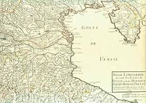
Condition: Good. 22 x 16 inches. Very Good. 17th Century hand colored map of Lower Lombardy. Some toning, and two one-inch tears at bottom edge. Text in French. Scarce.Nicholas Sanson (1600-1667) is considered the father of French cartography in its golden age from the mid-seventeenth century to the mid-eighteenth. Over the cour…se of his career he produced over 300 maps. His success can be chalked up to his geographic and research skills, but also to his partnership with Pierre Mariette. Previously, Sanson had worked primarily with the publisher Melchior Tavernier. Mariette purchased Tavernier's business in 1644. Sanson worked with Mariette until 1657, when the latter died. Mariette's son, also Pierre, helped to publish the Cartes générales de toutes les parties du monde.

Published by Paris, c.1680. 200 x 255mm (7¾ x 10 inches). 1680
Seller: Tooley, Adams & Co., Wallingford, OXON, United KingdomTooley, Adams & Co.
Contact seller3-star sellerCondition: Used
US$ 220.94
US$ 49.81 shippingShips from United Kingdom to U.S.A.Quantity: 1 available
Coloured; light age-toning to the edges of the paper and minor spotting to margins, overall a good example. A finely engraved map of the Holy Land with decorative title cartouche, engraved by Antony de Winter.

Published by Paris, 1683. 190 x 250mm (7½ x 9¾ inches). 1683
Seller: Tooley, Adams & Co., Wallingford, OXON, United KingdomTooley, Adams & Co.
Contact seller3-star sellerCondition: Used
US$ 220.94
US$ 49.81 shippingShips from United Kingdom to U.S.A.Quantity: 1 available
Coloured; light age-toning to the margins, overall a fine example. Two maps on one sheet: Thailand and the Malaysian Peninsular. Engraved by Antony de Winter.

Published by Paris, 1683. 200 x 285mm (7¾ x 11¼ inches). 1683
Seller: Tooley, Adams & Co., Wallingford, OXON, United KingdomTooley, Adams & Co.
Contact seller3-star sellerCondition: Used
US$ 262.37
US$ 49.81 shippingShips from United Kingdom to U.S.A.Quantity: 1 available
Coloured; light age-toning to the margins, otherwise a fine example. A map of South Africa, with decorative floral cartouche. Engraved by Antoine de Winter.
 More images
Published by PARIS Chez l?Auteur 1658 1658
Seller: PROCTOR / THE ANTIQUE MAP & BOOKSHOP, DORCHESTER, United KingdomPROCTOR / THE ANTIQUE MAP & BOOKSHOP
Contact seller5-star sellerCondition: Used
US$ 296.89
US$ 26.81 shippingShips from United Kingdom to U.S.A.Quantity: 1 available
Title cartouche to lower left corner. Blank on verso. In good condition. Some light tanning on edges, with a few faint foxing marks. With original outline hand colouring. Engraved Size 17.5 x 23 inches Nicolas Sanson (1600-1667) sometimes called Nicolas Sanson d'Abbeville or Sanson d'Abbeville, was the most important F…rench cartographer of the 17th century. Tooley called Sanson "the founder of the French school of cartography." He began making maps in the late 1620s, and in the 1630s he was working with Melchior Tavernier. Later, Sanson worked in concert with the print publisher Pierre Mariette, with whom he published his great atlas: Cartes générales de toutes les parties du monde (1658). After Sanson's death in 1667, his son Guillaume carried on the business in partnership with Alexis Hubert Jaillot. Guillaume established himself as a very important French mapmaker in his own right.
L'Europe divisee suivant l'etendue de ses principaux Etats, subdivises en leurs principales Provinces
SANSON D'ABBEVILLE, Nicholas (1600-1667)-DE VAUGONDY, Gilles Robert (1688-1766)
Published by Paris: 1738 1738
Seller: Arader Galleries - AraderNYC, New York, NY, U.S.A.Arader Galleries - AraderNYC
Contact seller5-star seller2 sheets joined (sheet size 21 6/8 x 30 inches; 18 x 27 7/8 inches to the neat line), full margins showing the plate mark. A fine engraved detailed map of Europe, the title within a nicely ornamented Louis-XV-style cartouche upper right, scale within a small sober cartouche, the left part of the map is a kind of manual which giv…es some information on the scientific information the map provides in political geography, natural geography and astronomic geography; with original hand color in outline (spot on the upper middle margin, vertical fold marks, a little toned at the edges). A fine and very interesting political, natural and astronomical map of Europe. Gilles Robert de Vaugondy (1688-1766), also known as Le Sieur or Monsieur Robert, and his son, Didier Robert de Vaugondy (c.1723-1786), were leading mapmakers in France during the 18th century. In 1757, they published The 'Atlas Universel' in which they integrated older sources with more modern maps. This dialogue between old and new is also suitable for this map, as it is originally made by Nicholas Sanson (1600-1667), who was the founder of the French school of cartography.
Published by c.1683, Paris 1683
- Map
Seller: Alexandre Antique Prints, Maps & Books, Toronto, ON, CanadaAlexandre Antique Prints, Maps & Books
Contact seller4-star sellerCondition: Used - Very good
US$ 375.00
US$ 6.00 shippingShips from Canada to U.S.A.Quantity: 1 available
Condition: Very Good. French map showing Poland and the surrounding region.Nicolas Sanson (1600?1667) was a renowned French cartographer, termed by some as the "father of French cartography." His works are known for their incorporation of the most up to date information of the time, and their clean, modern style., Size : 188x256… (mm), 7.40x10.08 (Inches), Hand Colored.

Published by Paris, c.1650. 520 x 430mm (20½ x 17 inches). 1650
Seller: Tooley, Adams & Co., Wallingford, OXON, United KingdomTooley, Adams & Co.
Contact seller3-star sellerCondition: Used
US$ 359.03
US$ 49.81 shippingShips from United Kingdom to U.S.A.Quantity: 1 available
Uncoloured; dark impression, overall a fine example. A superbly engraved title page, showing Atlas holding the World aloft, a winged herald and scholars studying the globe below.
Published by Paris 1660
- Map
Seller: Alexandre Antique Prints, Maps & Books, Toronto, ON, CanadaAlexandre Antique Prints, Maps & Books
Contact seller4-star sellerCondition: Used - Very good
US$ 475.00
US$ 6.00 shippingShips from Canada to U.S.A.Quantity: 1 available
Condition: Very Good. French map of the Holy Land, with a decorative cartouche.Nicolas Sanson (1600?1667) was a renowned French cartographer, termed by some as the "father of French cartography." His works are known for their incorporation of the most up to date information of the time, and their clean, modern style. , Size : 38…5x485 (mm), 15.16x19.09 (Inches), Hand Colored.
 More images
Published by Petrum Mariette: Lutetiae Parisiorum 1650
- First Edition
- Map
Seller: Sequitur Books, Boonsboro, MD, U.S.A.Sequitur Books
Contact seller5-star sellerCondition: Used - Very good
US$ 500.00
US$ 4.97 shippingShips within U.S.A.Quantity: 1 available
Maps. Condition: Very Good. First Edition. [Ancient Europe : The Roman Empire] Fine hand-colored, double-page engraved map of Roman provinces of Europe. Mounted in wood frame, with wooden side handles. Dimensions of mounted image: 40 x 56 cm. (53 x 69.5 cm in frame). Latin province names, cities, seas. This is an oversized or he…avy book, which requires additional postage for international delivery outside the US.


