
Schneiderschen (1 results)
 More images
Seller: Douglas Stewart Fine Books, Armadale, VIC, AustraliaDouglas Stewart Fine Books
Contact seller4-star sellerCondition: Used
US$ 874.50
US$ 37.00 shippingShips from Australia to U.S.A.Quantity: 1 available
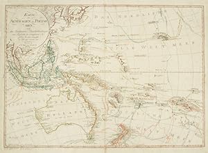
und Tagebücher der vorzüglichsten Seefahrer bis 1789 entworffen im Jahr 1792, vermehrt 1796. Nürnberg : in der Weigel und Schneiderschen Handlung mit Kayserl. allergnl. Privil., 1796 [but probably 1804-1808]. Copperplate engraved map with hand colouring, 460 x 650 mm, verso with contemporary title in large, bold manuscript AUSTR…ALIEN;central vertical fold, as issued;a fine copy. A map of Australia (lettered Neu Holland), the Indonesian archipelago and southwest Pacific; relief shown by hachures; shows the tracks of Tasman, Cook, Furneaux, Carteret, Wallis, Bougainville, Byron, Marshall and Shortland, Sarville, Nordwarts, Scarborough, and perhaps most significantly, that of Bass: Tasmania is separated from the mainland by "Basses Strasse", and a stretch of imagined coastline (marked as "unknown") represents the eastern Australian Bight. Text in German. Tooley, 1333. Copies are held in two Australian collections (National Library of Australia; State Library of New South Wales).
