Order Total (1 Item Items):
Shipping Destination:

Seitz Johann Baptist (4 results)
Feedback
Skip to main search results
Search filters
Product Type
- All Product Types
- Books (4)
- Magazines & Periodicals (No further results match this refinement)
- Comics (No further results match this refinement)
- Sheet Music (No further results match this refinement)
- Art, Prints & Posters (No further results match this refinement)
- Photographs (No further results match this refinement)
- Maps (No further results match this refinement)
- Manuscripts & Paper Collectibles (No further results match this refinement)
Condition Learn more
- New (No further results match this refinement)
- As New, Fine or Near Fine (No further results match this refinement)
- Very Good or Good (No further results match this refinement)
- Fair or Poor (No further results match this refinement)
- As Described (4)
Binding
Collectible Attributes
- First Edition (2)
- Signed (No further results match this refinement)
- Dust Jacket (No further results match this refinement)
- Seller-Supplied Images (4)
- Not Print on Demand (4)
Language (2)
Free Shipping
- Free Shipping to U.S.A. (No further results match this refinement)
Seller Location
Seller Rating
-

"Relief der Haupt- und Residenzstadt M�nchen" : das Stadtmodell von Johann Baptist Seitz ; 1841 - 1863.
Published by M�nchen : Bayerisches Nationalmuseum,, 2000
ISBN 10: 3925058451 ISBN 13: 9783925058455
Language: German
Seller: Antiquariat Berghammer, Gr�felfing, Germany
Association Member: GIAQ
Seller rating 5 out of 5 stars

First Edition
US$ 16.71
Convert currencyUS$ 33.60 shipping from Germany to U.S.A.Quantity: 1 available
Add to basket8�, OPp, sch�ner Zust. 1. Aufl. 64 S. : �berw. Ill., Kt. Sprache: Deutsch Gewicht in Gramm: 900.
-

Postkarte Des Koenigreichs Baiern mit den Umgebungen angraenzender Staaten.
Published by M�nchen, A. Dreer, 1823
Seller: Buch- und Kunst-Antiquariat Flotow GmbH, Ottobrunn, Germany
Seller rating 5 out of 5 stars
US$ 954.80
Convert currencyUS$ 23.17 shipping from Germany to U.S.A.Quantity: 1 available
Add to basketIn Orig.-Schuber, 72 x 82,5 cm. Zeigt das K�nigreich Bayern mit angrenzenden Regionen. Mit ornamentaler Umrahmung, zwei Tabellen mit Postrouten und Post�mtern, sowie einer gro�en Kartusche mit einer Fernansicht von M�nchen, umgeben von einer Waldlandschaft im Vordergrund. Selten mit der vollen Angabe der Stecher- und Drucker-Angabe. - Nur leicht gebr�unt, sonst in sch�ner, sauberer Erhaltung Grenzkolorierte Kupferstich-Karte, mehrfach gefaltet in 24 Segmenten auf Leinen aufgezogen.
-
Postkarte des Koenigreichs Bayern mit den Umgebungen angraenzender Staaten.
Published by (M�nchen, Dreer),, 1831
Language: German
Seller: Matthaeus Truppe Antiquariat, Graz, Austria
Seller rating 5 out of 5 stars
First Edition
US$ 574.68
Convert currencyUS$ 44.03 shipping from Austria to U.S.A.Quantity: 1 available
Add to basketGrenzkolorierte Kupferstichkarte in 18 auf Lwd. aufgezogenen Segmenten. Die erste Ausgabe war 1810 erschienen. - Hervorragend von Johann Baptist Seitz und Johann Carl Schleich gestochenen Karte von Bayern und seiner Umgebung mit Einzeichnung der Postrouten auf den Vorarbeiten des Hauptmanns am Ingenieurbureau der Reservearmee Alois von Coulon basierend. Die vorliegende Postkarte ragt als die beste �bersichtskarte zu Beginn des 19. Jahrhunderts �ber andere vergleichbare Kartenwerke heraus. Dargestellt ist das Gebiet von Aachen bis Linz. - Leicht fleckig. *** *** Copyright: Matthaeus TRUPPE Buchhandlung & Antiquariat - Stubenberggasse 7 - A-8010 Graz - ++43 (0)316 - 829552 *** *** Sprache: Deutsch Gewicht in Gramm: 300 Ca. 73 cm x 86 cm. In Pp.-Schuber der Zeit (starke Gebrssprn.).
-
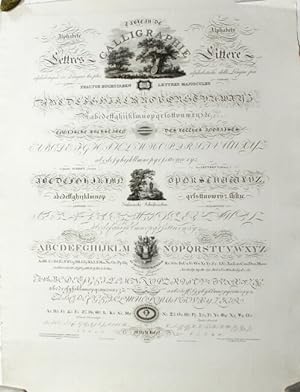
Alphab�te de �blichsten Sprachen . Tableau de calligraphie . Alphabets of languages the most customary
Published by Anton Dreer, Munich, 1816
Seller: Rulon-Miller Books (ABAA / ILAB), St. Paul, MN, U.S.A.
Association Member: ABAA ILAB RMABA
Seller rating 5 out of 5 stars
Large, beautiful broadside in fine condition, approx. 30�" x 23�" (775 x 590 mm.), engraved with 15 samples of various fonts intermingled with 5 engraved vignettes, printed on thick wove paper with deckled edge. A rare type specimen sheet with ornaments for the use of map-makers. The imprint notes in French and German that it was "composed, engraved, and published by J. B. Seitz" (1786-1859), an engraver for the Royal Bavarian Bureau of Statistics and Topography (K�niglichen Bayrischen Statisch-Topographischen Bureau), which was responsible for the manufacture of official maps, charts, and plans. He was one of the first technicians to work on prototypes of lithographic maps, and was considered a leader in the fields of cartographic design and printing. This specimen sheet was presumably printed for cartographic institutes, publishers, and mapmakers. The subtitle, Alphabets of languages the most customary, is in German, English, French, and Italian, and the remaining captions, all in different ornamental fonts, are in German and French, as is the imprint. Included are ornate alphabets in Fraktur, several different italics (dubbed English, Italian, and French Letters), gothic, roman, and Greek alphabets, and the German Currentschrift. Three of the engraved vignettes, arrayed down the center of the sheet are pictorial. At the top is a romantic landscape in which a plaque leaning against a tree bears the appropriate motto "Nihil est Simul et Inventum et Perfectum." The others show a funerary monument in a pastoral glade, and a military trophy with the emblematic initials of Rome (SPQR) and the motto "Et arevivitur patriae" below. Apparently unrecorded. No copies found in any of the German national library OPACs and none in OCLC or NUC. For information of Seitz see R. A. Winkler's Die Fr�hzeit der deutschen Lithographie (1975).