
Order Total (1 Item Items):
Shipping Destination:

Seutteri Matth (8 results)
Skip to main search results
Search filters
Product Type
- All Product Types
- Books (2)
- Magazines & Periodicals (No further results match this refinement)
- Comics (No further results match this refinement)
- Sheet Music (No further results match this refinement)
- Art, Prints & Posters (6)
- Photographs (No further results match this refinement)
- Maps (No further results match this refinement)
- Manuscripts & Paper Collectibles (No further results match this refinement)
Condition Learn more
- New (No further results match this refinement)
- As New, Fine or Near Fine (1)
- Very Good or Good (No further results match this refinement)
- Fair or Poor (No further results match this refinement)
- As Described (7)
Binding
- All Bindings
- Hardcover (No further results match this refinement)
- Softcover (No further results match this refinement)
Collectible Attributes
- First Edition (No further results match this refinement)
- Signed (No further results match this refinement)
- Dust Jacket (No further results match this refinement)
- Seller-Supplied Images (6)
- Not Print on Demand (8)
Language (2)
Price
- Any Price
- Under US$ 25 (No further results match this refinement)
- US$ 25 to US$ 50 (No further results match this refinement)
- Over US$ 50
Free Shipping
- Free Shipping to U.S.A. (No further results match this refinement)
Seller Location
Seller Rating
-
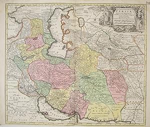
Seutter, Matthaeus/ Seuttero Matth. / Seutteri Matthaei 1678 - 1757 (illustrator). Kupferstich, altkoloriert, sehr sch�ne Landkarte von Persien, vom persischen Golf zum Kaspischen Meer, vom Schwarzen Meer bis Tibet/Indien, zeigt Iran, Irak, Afghanistan, Pakistan, Turkmenistan, Tadschikistan Usbekistan, Aserbaidschan, Georgien, Teile von Arabien, Kasachstan und Indien; very rare, decorative and originally coloured map, copper engraving of the Persian Empire, nice cartouche with figures in local costumes die Karte ist in einem guten Zustand, breiter Rand, unterhalb ist weniger Rand, Mittelfalte, center fold, good condition. Druckgrafik.
-

ATLAS MINOR PRAECIPUA ORBIS TERRARUM IMPERIA, REGNA ET PROVINCIAS, GERMANIAE POTISSIMUM, TABELLI 20 EXACTE DELINEATIS SISTENS USUI, MILITIAE DUCUM AC PEREGRINANTIUM MAXIME ACCOMODATUS OPERA
Published by casa editrice: LOTTERI anno: CIRCA 1740/50 citta': AUGSURG, 1740
Seller: libreria antiquaria e antichit� Onofri, Roma, RM, Italy
Seller rating 5 out of 5 stars

LEGATURA DEL '900 IN CARTONCINO, ATLANTE COMPLETO DELLE SUE 20 CARTE + IL FRONTESPIZIO. COLLAZIONATO. TUTTE LE CARTE SONO A COLORI D'EPOCA. ATLANTE MOLTO RARO numero pagine: 21 FOGLI formato: ALBUM 29.2X22.3 stato conservazione: MEDIOCRE, MANCANZE AI MARGINI, ALCUNI RESTAURATI, ALCUNE SCRITTE E LIEVI ALONI, MACCHIE AI VERSI DELLE TAVOLE, IL MARGINE DELLA TAVOLA DELL'ITALIA E' RIDOTTO NELLA PARTE SUPERIORE ED INFERIORE.
-
Circulus Austria accuratissime defignatus opera et impenfis Matth. Seutteri S. C. M. Geogr. Aug. Vind.
Language: Latin
Published by Augsburg, Ioh. Mart. Will [nach ], 1762
Art / Print / Poster
Altkolorierter Kupferstich. ca. 18,7 x 24,5 cm. In illustriertem Orig.-Etui. - Etui r�ckw. m. hds. Titelei, Gbrsp., Karte etw. fleckig, gefaltet. - Vgl. Schaup 114ff. Aus dem "Atlas Minor." des M. Seutter, die Reisekarten-Ausgabe.
-

Maiestas Austriaca sive Circulus Archi Ducat. Austriae per Matth. Seutter. S. C. M. Geogr. Aug. Vind. 31
Language: Latin
Published by Augsburg, Ioh. Mart. Will [nach ], 1762
Art / Print / Poster
Altkolorierter Kupferstich. ca. 18,5 x 24,5 cm. In illustriertem Orig.-Etui. - Etui r�ckw. m. hds. Titelei, Gbrsp., Karte etw. fleckig, zwei Einrisse (ca. 6 cm) entlang der Mittelfalte, zwei kl. L�suren entlang der unteren Kante, gefaltet. - Vgl. Schaup 114f. Aus dem "Atlas Minor." des M. Seutter, die Reisekarten-Ausgabe.
-

Principali Dignitate Gaudens Comit. Tirolis. Episcopat. Tridentinum et. Brixiensem, exactissime difignata cura et manu Matth. Seutter S. Caes. M. Geogr. Aug. Vindel. 34
Language: Latin
Published by Augsburg, Ioh. Mart. Will [nach ], 1762
Art / Print / Poster
Altkolorierter Kupferstich. ca. 18,5 x 24,5 cm. In illustriertem Orig.-Etui. - Etui berieben, Gbrsp. u. r�ckw. m. hds. Titelei, Karte etw. fleckig, gefaltet. - Vgl. Schaup 114ff. Aus dem "Atlas Minor." des M. Seutter, die Reisekarten-Ausgabe.
-
Postarum diverticula et mansiones per Germaniam et Confin. Prov. opera M. Seutteri S. C. M. G. Aug. V. 30
Language: Latin
Published by Augsburg, Ioh. Mart. Will [nach ], 1762
Art / Print / Poster
Altkolorierter Kupferstich. ca. 18,7 x 24,5 cm. In illustriertem Orig.-Etui. - Etui r�ckw. m. hds. Titelei, Gbrsp., Karte etw. fleckig, ein ca. 4 cm Einriss entlang eines Buges, gefaltet. - Vgl. Schaup 114ff. Aus dem "Atlas Minor." des M. Seutter, die Reisekarten-Ausgabe.
-
Regni Hungariae. Delineatio Studio M. Seutt. S. C. M. Geogr. Aug. Vind.
Language: Latin
Published by Augsburg, Ioh. Mart. Will [nach ], 1762
Art / Print / Poster
Altkolorierter Kupferstich. ca. 19 x 25 cm. In illustriertem Orig.-Etui. - Etui m. kl. Tintenflecken u. r�ckw. m. hds. Titelei, Karte etw. fleckig, gefaltet. - Vgl. Schaup 114f. Aus dem "Atlas Minor." des M. Seutter, die Reisekarten-Ausgabe.
-

Kein Einband. Condition: Sehr gut. Seutter, Matthaeus/ Seuttero Matth. / Seutteri Matthaei 1678 - 1757 (illustrator). Original, altkolorierte Kupferstich Landkarte von Matthaei Seutteri, 1727. Andalusien (Andaluci�) Spanien/Espana/Spain, Gibraltar. Originally coloured, antique map - copper engraving. Sehr sch�ne Landkarte von S�dspanien, zwischen Sanl�car de Barrameda, Gibraltar und Motril, unterhalb befinden sich f�nf Inselkarten: mit Malaga, Gibraltar, Cadix, Ceuta mit Umgebung in Afrika und eine Karte der Baleareninsel Menorca (Minorca). This beautiful map shows the south of Spain, embracing the area between Motril in the province of Granada in the east, Gibraltar in the south and Cadiz and Sanl�car de Barrameda in the west. In this map you find Menorca, Ceuta, views of Malaga, Gibraltar and Cadiz. The map shows the area after the War of the Spanish Succession (1701 - 1714) when Gibraltar was given to Britain in 1713. Die Karte ist in einem sehr guten Zustand, breiter Rand, Mittelfalte, center fold, very good condition. Kartengr��e: 58cm x 50cm, Blattgr��e: 63cm x 53,5cm. Druckgrafik.
