
Order Total (1 Item Items):
Shipping Destination:

Seutteri Matthaei (6 results)
Skip to main search results
Search filters
Product Type
- All Product Types
- Books (4)
- Magazines & Periodicals (No further results match this refinement)
- Comics (No further results match this refinement)
- Sheet Music (No further results match this refinement)
- Art, Prints & Posters (2)
- Photographs (No further results match this refinement)
- Maps (No further results match this refinement)
- Manuscripts & Paper Collectibles (No further results match this refinement)
Condition Learn more
- New (No further results match this refinement)
- As New, Fine or Near Fine (1)
- Very Good or Good (3)
- Fair or Poor (No further results match this refinement)
- As Described (2)
Binding
- All Bindings
- Hardcover (No further results match this refinement)
- Softcover (1)
Collectible Attributes
- First Edition (No further results match this refinement)
- Signed (No further results match this refinement)
- Dust Jacket (No further results match this refinement)
- Seller-Supplied Images (6)
- Not Print on Demand (6)
Language (1)
Price
- Any Price
- Under US$ 25 (No further results match this refinement)
- US$ 25 to US$ 50 (No further results match this refinement)
- Over US$ 50
Free Shipping
- Free Shipping to U.S.A. (No further results match this refinement)
Seller Location
Seller Rating
-

Atlas Minor praecipua Orbis terrarum Imperia Regna et Provincias Germaniae Potissimum, Tabellis 66 exacte delineatis sistens usui . Opera Matthaei Seutteri.
Published by Lotteri 1740-50, 1740
Seller: Libreria La Fenice di Pietro Freggio, Brescia, BS, Italy
Seller rating 5 out of 5 stars

Brossura. Condition: buono. In 8� oblungo (cm 21,5 x 33). Leg. in piena pelle coeva ad astuccio parzialmente stanca. Titolo impresso al piatto anteriore. Segni di consunzione, strappetti ai margini e alle cuffie. Le sguardie fisse presentano strappi e mancanze. Frontespizio inciso, pagine di legenda a stampa e 64 carte geografiche (da indice dovrebbero essere 66) in coloritura coeva. Gore. Tracce di polvere. Atlante che testimonia l'utilizzo didattico di questo genere di pubblicazioni geografiche nell'Italia del tardo XVIII secolo. Tra le carte � presente il planisfero, l'Europa, l'Africa, L'Asia, L'America meridionale e L'America settentrionale con la California ancora rappresentata come un'isola. Esemplare in buone condizioni.
-
Kein Einband. Condition: Gut. 50 x 57,5 cm gefaltete Landkarte, mit Mittelfalz, Papier altersbedingt etwas fleckig und gebr�unt, sonst GUTES EXEMPLAR---Blatt: 52,5 x 62,5 cm F�r Ihre Zufriedenheit versenden wir mit DHL und ausschlie�lich mit Trackingcode f�r eine sichere Sendungsverfolgung! Weitere Angebote unter antiquariat-kastanienhof , 1 Seiten. nein.
-
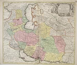
Seutter, Matthaeus/ Seuttero Matth. / Seutteri Matthaei 1678 - 1757 (illustrator). Kupferstich, altkoloriert, sehr sch�ne Landkarte von Persien, vom persischen Golf zum Kaspischen Meer, vom Schwarzen Meer bis Tibet/Indien, zeigt Iran, Irak, Afghanistan, Pakistan, Turkmenistan, Tadschikistan Usbekistan, Aserbaidschan, Georgien, Teile von Arabien, Kasachstan und Indien; very rare, decorative and originally coloured map, copper engraving of the Persian Empire, nice cartouche with figures in local costumes die Karte ist in einem guten Zustand, breiter Rand, unterhalb ist weniger Rand, Mittelfalte, center fold, good condition. Druckgrafik.
-

Principali dignitate gaudens comitat. Tirolis Episcopat. Tridentinum et Brixiensem.
Publication Date: 1740
Seller: BOTTEGHINA D'ARTE GALLERIA K�PROS, Rosignano Solvay, LI, Italy
Seller rating 2 out of 5 stars

Art / Print / Poster
No legatura. Condition: Buono. Augusta, 1740 circa. Tratta dall "Atlas novus indicibus instructus", incisione in rame, colore d'epoca, cm 50 x 58 (alla lastra). Carta raffigurante il territorio tirolese, l'impostazione � molto simile alla carta di J.B. Homann edita nel 1716. Anche le decorazioni che accompagnano il titolo ricordano quella dell' Homann, con la fortezza di Covelo sullo sfondo e diverse figure allegoriche nel primo piano. (Bibl. "Il territorio trentino - tirolese nell'antica cartografia" di Gino Tomasi, scheda n. 56). Ingiallimento della brachetta centrale, peraltro a pieni margini e in buono stato di conservazione.
-

Mappa Geographica Regionem Mexicanam et Floridam. Augsburgo, hacia 1730-40
Seller: Librer�a Anticuaria Antonio Mateos, Malaga, MA, Spain
Seller rating 5 out of 5 stars
Mappa Geographica Regionem Mexicanam et Floridam. Terrasque adjacentes, ut et Anteriores Americae Insulas, Cursius itidem et Reditus Navigantium vresus flumen Missisipi et alias Colonias ob oculos ponens cura et sumptibus. Augustae Vindelicorum (Augsburgo), hacia 1730-40, gran mapa de 50 x 57,5 cm., con los contornos de costas y de las posesiones de las distintas potencias coloreadas a mano de �poca. Insertados en el margen izquierdo contiene 4 peque�os planos de puertos estrat�gicos: La Habana, Panam�, Cartagena de Indias y Veracruz. (Dos peque�as restauraciones antiguas de refuerzo en el reverso. Documento clave de la rivalidad colonial en Am�rica del Norte y el Caribe antes de la Guerra de los Siete A�os, La Florida aparece a�n en poder de Espa�a. Es la versi�n original que m�s tarde copiar�an los Herederos de Homann y Lotter. Traza las rutas de la Flota de Indias y los galeones espa�oles entre Europa y Am�rica). Libros.
-

Kein Einband. Condition: Sehr gut. Seutter, Matthaeus/ Seuttero Matth. / Seutteri Matthaei 1678 - 1757 (illustrator). Original, altkolorierte Kupferstich Landkarte von Matthaei Seutteri, 1727. Andalusien (Andaluci�) Spanien/Espana/Spain, Gibraltar. Originally coloured, antique map - copper engraving. Sehr sch�ne Landkarte von S�dspanien, zwischen Sanl�car de Barrameda, Gibraltar und Motril, unterhalb befinden sich f�nf Inselkarten: mit Malaga, Gibraltar, Cadix, Ceuta mit Umgebung in Afrika und eine Karte der Baleareninsel Menorca (Minorca). This beautiful map shows the south of Spain, embracing the area between Motril in the province of Granada in the east, Gibraltar in the south and Cadiz and Sanl�car de Barrameda in the west. In this map you find Menorca, Ceuta, views of Malaga, Gibraltar and Cadiz. The map shows the area after the War of the Spanish Succession (1701 - 1714) when Gibraltar was given to Britain in 1713. Die Karte ist in einem sehr guten Zustand, breiter Rand, Mittelfalte, center fold, very good condition. Kartengr��e: 58cm x 50cm, Blattgr��e: 63cm x 53,5cm. Druckgrafik.
