

Order Total (1 Item Items):
Shipping Destination:

Sylvanus Bernado (1 results)
Skip to main search results
Search filters
Product Type
- All Product Types
- Books (1)
- Magazines & Periodicals (No further results match this refinement)
- Comics (No further results match this refinement)
- Sheet Music (No further results match this refinement)
- Art, Prints & Posters (No further results match this refinement)
- Photographs (No further results match this refinement)
- Maps (No further results match this refinement)
- Manuscripts & Paper Collectibles (No further results match this refinement)
Condition Learn more
- New (No further results match this refinement)
- As New, Fine or Near Fine (No further results match this refinement)
- Very Good or Good (No further results match this refinement)
- Fair or Poor (No further results match this refinement)
- As Described (1)
Binding
- All Bindings
- Hardcover (No further results match this refinement)
- Softcover (No further results match this refinement)
Collectible Attributes
- First Edition (No further results match this refinement)
- Signed (No further results match this refinement)
- Dust Jacket (No further results match this refinement)
- Seller-Supplied Images (1)
- Not Print on Demand (1)
Language (1)
Price
- Any Price
- Under US$ 25 (No further results match this refinement)
- US$ 25 to US$ 50 (No further results match this refinement)
- Over US$ 50
Free Shipping
- Free Shipping to U.S.A. (No further results match this refinement)
Seller Location
Seller Rating
-
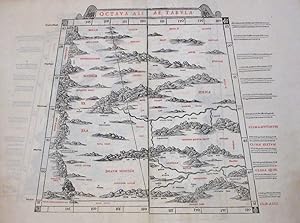
Octava Asiae Tabula
Published by Bernado Sylvanus, Venice, 1511
Seller: Argosy Book Store, ABAA, ILAB, New York, NY, U.S.A.
Seller rating 5 out of 5 stars

unbound. Map. Original woodcut print with printed color. Page measures 16 3/4" x 22". 1511. This rare Ptolemaic map of Central Asia features the regions east of the Caspian Sea with northern India and western China. Includes Scythia, Tajikistan, Xinjiang Uygur Zizhiqu (China), Kyrgyzstan. Geographic features include the Ganges and the Himalayas. Relief is beautifully rendered pictorially with places and natural features labeled. The margin includes notes on climate and latitude. The unusual perspective of the geographical and topographical elements is the highlight of these great map and the rugged terrain is wonderfully suited to the medium of woodcutting. This map, one of the earliest obtainable maps of the region, was published in Sylvanus' "Claudii Ptholemaei Alexandrini liber Geographicae", and is one of the earliest to exhibit printed color. Claudius Ptolemy (90-168 CE) was a Roman geographer and mathematician living in Egypt, who compiled his knowledge and theories about the world's geography into one seminal work. Although his maps did not survive, his mathematical projections and location coordinates did. During the Renaissance revival of Greek and Roman works, "Geographia" was rediscovered by monks and based upon Ptolemy's detailed instructions, the maps were recreated. The first printed edition of "geographia" with maps was published in Bologna in 1477, and Sylvanus followed not long after with his own edition in 1490 and again in 1511. Sylvanus was the first publisher to include updated information to the original maps. This map is in very good condition. Originally printed on two sheets, here joined on verso. Minor foxing and offsetting with minor creasing in top margin over the centerfold. A beautiful example of this rare map.
