
Tartaria (27 results)

- Hardcover
Seller: Antártica, Madrid, M, SpainAntártica
Contact seller5-star sellerCondition: New
US$ 18.83
US$ 20.63 shippingShips from Spain to U.S.A.Quantity: 1 available
Cartoné (tapa dura cartón). Condition: New. Dust Jacket Condition: Nuevo. 01. Originario, Serena (illustrator). LIBRO.

- Softcover
Seller: AG Library, Malaga, MA, SpainAG Library
Contact seller4-star sellerCondition: New
US$ 17.88
US$ 20.31 shippingShips from Spain to U.S.A.Quantity: 1 available
Condition: New. Idioma/Language: Español. *** Nota: Los envíos a España peninsular, Baleares y Canarias se realizan a través de mensajería urgente. No aceptamos pedidos con destino a Ceuta y Melilla.
- Softcover
Seller: KALAMO BOOKS, Burriana, CS, SpainKALAMO BOOKS
Contact seller5-star sellerCondition: New
US$ 18.82
US$ 20.47 shippingShips from Spain to U.S.A.Quantity: 1 available
Tapa blanda. Condition: Nuevo. Originario, Serena (illustrator).

- Hardcover
Seller: KALAMO BOOKS, Burriana, CS, SpainKALAMO BOOKS
Contact seller5-star sellerCondition: New
US$ 18.82
US$ 20.47 shippingShips from Spain to U.S.A.Quantity: 1 available
Carton. Condition: Nuevo.

- Softcover
Seller: KALAMO BOOKS, Burriana, CS, SpainKALAMO BOOKS
Contact seller5-star sellerCondition: New
US$ 18.82
US$ 20.47 shippingShips from Spain to U.S.A.Quantity: 1 available
Tapa blanda. Condition: Nuevo. Originario, Serena (illustrator).

- Softcover
Seller: KALAMO BOOKS, Burriana, CS, SpainKALAMO BOOKS
Contact seller5-star sellerCondition: New
US$ 18.82
US$ 20.47 shippingShips from Spain to U.S.A.Quantity: 1 available
Tapa blanda. Condition: Nuevo.
- Hardcover
Seller: KALAMO BOOKS, Burriana, CS, SpainKALAMO BOOKS
Contact seller5-star sellerCondition: New
US$ 18.82
US$ 20.47 shippingShips from Spain to U.S.A.Quantity: 1 available
Carton. Condition: Nuevo. Originario, Serena (illustrator).
- Hardcover
Seller: KALAMO BOOKS, Burriana, CS, SpainKALAMO BOOKS
Contact seller5-star sellerCondition: New
US$ 18.82
US$ 20.47 shippingShips from Spain to U.S.A.Quantity: 1 available
Carton. Condition: Nuevo. Originario, Serena (illustrator).
- Softcover
Seller: Antártica, Madrid, M, SpainAntártica
Contact seller5-star sellerCondition: New
US$ 18.83
US$ 20.63 shippingShips from Spain to U.S.A.Quantity: 1 available
Rústica. Condition: New. Dust Jacket Condition: Nuevo. LIBRO.
- Hardcover
Seller: Antártica, Madrid, M, SpainAntártica
Contact seller5-star sellerCondition: New
US$ 18.83
US$ 20.63 shippingShips from Spain to U.S.A.Quantity: 1 available
Cartoné (tapa dura cartón). Condition: New. Dust Jacket Condition: Nuevo. 01. Una pequeña isla quiere llegar a ser tan grande que todo el mundo pueda percibirla por fin. Pero en realidad lo que busca es el secreto que hay en su interior, por el cual siente una gran atracción. Entonces pide ayuda a sus amigos cercanos, pero por d…esgracia ellos no pueden ayudarla. Y justo cuando ya iba a rendirse porque nadie podía ayudarla, en un momento inesperado, encuentra a la persona adecuada, que ama toda su belleza y esplendor. po entre la medianoche y el amanecer, cuando la mayora de la gente muere, cuando el sueño es más profundo, cuando las pesadillas son más apetecibles. La hora del lobo es también la hora en que nacen más niños.la fiesta, pero su cabeza está junto a su padre enfermo en un hospital.elat ¿personal i intransferible¿ que és també la hist.ria de molts andorrans que van emigrar per. que han conservat, de generació en generació, una vinculació amb el pas. sobre perdedores en la que lo importante no es saber quién es el asesino.a colaboración de la Conselleria dÆEducació, Cultura i Esport de la Generalitat Valenciana e incluye un eplogo s. LIBRO.
- Softcover
Seller: KALAMO BOOKS, Burriana, CS, SpainKALAMO BOOKS
Contact seller5-star sellerCondition: New
US$ 18.82
US$ 20.47 shippingShips from Spain to U.S.A.Quantity: 1 available
Tapa blanda. Condition: Nuevo.
- Hardcover
Seller: KALAMO BOOKS, Burriana, CS, SpainKALAMO BOOKS
Contact seller5-star sellerCondition: New
US$ 18.82
US$ 20.47 shippingShips from Spain to U.S.A.Quantity: 1 available
Carton. Condition: Nuevo.

- Hardcover
Seller: Libros Tobal, Ajalvir, M, SpainLibros Tobal
Contact seller5-star sellerCondition: New
US$ 17.39
US$ 29.34 shippingShips from Spain to U.S.A.Quantity: 8 available
Condition: Nuevo. COLECCIÓN: WOOOBOOKS WOOOBOOKS - CUESTIONES PERSONALES Y SOCIALES: AUTOCONOCIMIENTO. Originario, Serena (illustrator).

- Hardcover
Seller: Libros Tobal, Ajalvir, M, SpainLibros Tobal
Contact seller5-star sellerCondition: New
US$ 17.39
US$ 29.34 shippingShips from Spain to U.S.A.Quantity: 8 available
Condition: Nuevo. COLECCIÓN: WOOOBOOKS WOOOBOOKS - ALBUMES ILUSTRADOS | CUESTIONES PERSONALES Y SOCIALES: AUTOCONOCIMIENTO | RELATOS DE AVENTURAS (INFANTIL/JUVENIL).

- Hardcover
Seller: Libros Tobal, Ajalvir, M, SpainLibros Tobal
Contact seller5-star sellerCondition: New
US$ 17.39
US$ 29.34 shippingShips from Spain to U.S.A.Quantity: 8 available
Condition: Nuevo. COLECCIÓN: WOOOBOOKS WOOOBOOKS - CIENCIA FICCION (INFANTIL/JUVENIL).
- Hardcover
Seller: Imosver, PONTECALDELAS, PO, SpainImosver
Contact seller5-star sellerCondition: New
US$ 17.88
US$ 32.78 shippingShips from Spain to U.S.A.Quantity: 1 available
Condition: Nuevo. Sinopsis En un bosque mágico, Lilaurora, un hada diminuta, anhelaba hacer brillar las estrellas. Con Griseldo, el sabio mago, recolectó polvo estelar y creó un elixir. Lilaurora, leyenda viviente, muestra cómo la magia pequeña logra grandes cosas. Su historia inspira, y los sueños se vuelven realidad con valent…ía y fe. Valores implícitos El personaje de este cuento nos transmite una serie de valores muy importantes en la vida, como son la determinación, la valentía y el trabajo en equipo, gracias a los cuales se pueden lograr grandes cosas.
Published by BABIDI-DU 2024
- Softcover
Seller: Antártica, Madrid, M, SpainAntártica
Contact seller5-star sellerCondition: New
US$ 18.83
US$ 20.63 shippingShips from Spain to U.S.A.Quantity: 1 available
Rústica. Condition: New. Dust Jacket Condition: Nuevo. 01. LIBRO.

- Hardcover
Seller: libreriauniversitaria.it, Occhiobello, RO, Italylibreriauniversitaria.it
Contact seller4-star sellerCondition: New
US$ 17.88
US$ 20.57 shippingShips from Italy to U.S.A.Quantity: Over 20 available
Condition: NEW.
- Hardcover
Seller: Kennys Bookstore, Olney, MD, U.S.A.Kennys Bookstore
Contact seller5-star sellerCondition: New
US$ 57.45
US$ 10.50 shippingShips within U.S.A.Quantity: 2 available
Condition: New. . hardcover. . . . . . Books ship from the US and Ireland.

- Hardcover
Seller: Rarewaves.com USA, London, LONDO, United KingdomRarewaves.com USA
Contact seller5-star sellerCondition: New
US$ 45.90
Free ShippingShips from United Kingdom to U.S.A.Quantity: 1 available
Hardback. Condition: New.

- Hardcover
Seller: Libros Tobal, Ajalvir, M, SpainLibros Tobal
Contact seller5-star sellerCondition: New
US$ 17.39
US$ 29.34 shippingShips from Spain to U.S.A.Quantity: 8 available
Condition: Nuevo. COLECCIÓN: WOOOBOOKS WOOOBOOKS - ALBUMES ILUSTRADOS | CUESTIONES PERSONALES Y SOCIALES: AUTOCONOCIMIENTO. Originario, Serena (illustrator).
- Hardcover
Seller: Kennys Bookshop and Art Galleries Ltd., Galway, GY, IrelandKennys Bookshop and Art Galleries Ltd.
Contact seller5-star sellerCondition: New
US$ 69.17
US$ 12.04 shippingShips from Ireland to U.S.A.Quantity: 2 available
Condition: New. . hardcover. . . . . .

- Hardcover
Seller: Rarewaves.com UK, London, United KingdomRarewaves.com UK
Contact seller5-star sellerCondition: New
US$ 43.13
US$ 85.85 shippingShips from United Kingdom to U.S.A.Quantity: 1 available
Hardback. Condition: New.

- Softcover
Seller: Buchpark, Trebbin, , GermanyBuchpark
Contact seller5-star sellerCondition: Used - Fine
US$ 17.39
US$ 120.35 shippingShips from Germany to U.S.A.Quantity: 1 available
Condition: Sehr gut. Zustand: Sehr gut | Sprache: Italienisch | Produktart: Bücher | Keine Beschreibung verfügbar.

- Map
Seller: Geographicus Rare Antique Maps, Brooklyn, NY, U.S.A.Geographicus Rare Antique Maps
Contact seller4-star sellerGood. Marginal mend just impacting border on the right; some creases. Else very good. Size 11.25 x 13.5 Inches. This is a 1740 Italian edition of Isaac Tirion's map of Tartary, or Russia in Asia. This is one of the few obtainable derivative maps to be based upon the little-known but groundbreaking cartography of Phillip Johann v…on Strahlenberg, created while he was a prisoner in Tobolsk. The Source Tirion's work, presented as 'drawn from the latest observations,' has often been ascribed, likely in error, to Guillaume De l'Isle. This map does not at all resemble De l'Isle's map of the same area. Rather, Tirion's 1732 original was indeed drawn from the truly state-of-the-art 1730 map of Phillip Johann von Strahlenberg. A cursory comparison between this map, those of De l'Isle, and the 1730 Strahlenberg makes the connection plain, on the strength of its depiction of the north and east coastlines. The shared detail of the Mare/Lacus Kamischnor (probably the wetlands of Kazakhstan and Uzbekistan) and the identical treatment of Lake Baikal on both maps confirms the connection. Tirion's choice of source was wise: Strahlenberg's 1730 map was the largest, most groundbreaking, and unique map of Russia to appear in the first half of the 18th century. Its presentation of a potential Northeast Passage, and its pre-Bering mapping of the Bering Strait made it among the most compelling works of the mapping of Asian Russia. Strahlenberg's enforced proximity to his subject (owing to his decades as a prisoner of war in Tobolsk) made his work all the more authoritative, improving sharply on the work of the area produced in the 17th century by Witsen, and the early 18th-century efforts of De l'Isle. The Dezhnev Anomaly or Witsen's Peninsula Nicolas Witsen's mapping does not disappear in Strahlenberg's work; for example, Witsen's Peninsula - here named ' Capo Suetoinos ' - can be seen extending from Siberia's northeastern coast just south of the Kolyma River. The Mysterious Island of Puchochotski One of the hallmarks of the Strahlenberg map appearing here is Puchochotski Island - the crescent shaped island at the easternmost extreme of this map. This island is mapped on only a few obscure Russian manuscripts of the early eighteenth century and was probably related to the discoveries of Petr Popov, who was sent from Anadyrsk to explore the Chukchi Peninsula in 1711. Popov returned with indigenous reports of a large island one day's voyage east of the Peninsula - without question representing Chukchi knowledge of the Behring Strait and Alaska: thus - Puchochotski Island is actually one of the first depictions of Alaska, based on native report. An Unsung Map Leo Bagrow had lamented in Imago Mundi that: It is to be regretted that Strahlenberg's map has so far not been studied to any large extent. After Remezov, it is the second most important source of historical geographical information about Siberia. Yet it did not have a great influence on maps of the following period and, in a way, stands apart. And yet, here in Tirion's map and its Italian copy, is evidence that Strahlenberg's cartography was in fact disseminated and presented as 'the latest observations,' albeit failing to apply the long-suffering Strahlenberg's name to any of it. Publication History and Census This map was composed and first printed by Isaac Tirion in 1732. The present copy was engraved in Venice for inclusion in Giambatista Albrizzi's 1740 Atlante Novissimo, Che Contiene Tutte Le Parti Del Mondo. We see one example of the separate map in OCLC. The Atlante is well represented in institutional collections. References: OCLC 638249688 (miscataloged as De l'Isle).

- Map
Seller: Geographicus Rare Antique Maps, Brooklyn, NY, U.S.A.Geographicus Rare Antique Maps
Contact seller4-star sellerVery good. Marginal mends at centerfold. Some light spotting, superb original color. Size 17.25 x 21.5 Inches. This beautifully engraved and colored map is Frederick de Wit's 1680 map of Central Asia and the Far East, including Persia, China, Japan and Siberia. It reaches from the eastern Caspian Sea to the Pacific, and from the… mouth of the Ganges in the south to the mouth of the Ob in Siberia. This represented the state of the art of Dutch cartography of northeastern Asia prior to the groundbreaking map of Nicolaas Witsen. The treatment of Japan and Yedso reflects the journey of Maarten Gerritsz Vries and the northeastern bulge evident on the maps of Blaeu and Jansson has been truncated here. The regions of central Asia are replete with descriptive texts, some of which were retained from the 15th century maps of Fra Mauro, and even from the narrative of Marco Polo. These focus particularly on the empire of the Grand Khan, and on various putative Christian kingdoms. The Great Wall of China is depicted. Apocryphal Lake Chiamay The mythical Lake of Chiamay, or Chiang Mai, appears at the south of the map, roughly in what is today Assam, India. Early cartographers postulated that such a lake must exist to source the four important Southeast Asian river systems: the Irrawaddy, the Dharla, the Chao Phraya, and the Brahmaputra. This lake began to appear on maps of Asia as early as the 16th century and persisted well into the mid-18th century. Its origins are unknown but may come from a lost 16th century geography prepared by the Portuguese scholar Joao de Barros. The map is embellished with a lovely strapwork cartouche flanked with putti , but it is not abundantly decorated. This stage of Dutch mapmaking began to strip away ornament in favor of detail, as more of the latter became available for presentation. Publication History and Census This map was engraved for Frederick de Wit by Jan Lhuillier as early as 1662. It appeared in De Wit's atlas in this form until perhaps 1688. After 1689 the map's title was changed to indicate De Wit's receipt of a privilege. At this point Lhuillier's imprint was effaced, possibly to prevent any legal confusion over to whom the privilege had been granted. The present example, lacking any privilege, was certainly printed prior to 1688. The sharpness of the image suggests an early strike. In various editions this map is well represented in institutional collections. References: OCLC 64025500. Rumsey 12220.072.
Language: German
- First Edition
- Map
Seller: Antiquariat Norbert Haas, Bedburg-Hau, , GermanyAntiquariat Norbert Haas
Contact seller5-star sellerCondition: Used
US$ 767.39
US$ 68.77 shippingShips from Germany to U.S.A.Quantity: 1 available
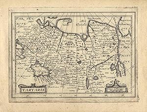
Kupferstich aus Trésor des cartes geographiques b. Jean Boisseau in Paris, 1643, 13 x 18,8 Not by Pastoureau! - 1. Ausgabe u. 1. Zustand! - Zeigt Sibirien u. die Mongolei vom Ural bis zum Pazifischen Ozean, sowie das Nordpolarmeer mit Nova Zembla u. die Beringstrasse (Bering Strait) mit Alaska; am unteren rechten Kartenrand Kore…a als Insel. - Unten links Titelkartusche; unten rechts Kartusche mit Meilenzeiger. - Die erste Ausgabe des Atlases erschien bei Boisseau 1643, es folgten Auflagen von Henault, Boissevin, Berey, Tassin, Picart, Antoine de Fer, Jourdain, Nicolas de Fer, Jollain und Huot. - Der Zustand ist abweichend von den bekannten Exemplaren! (z.B. Keine Nummer unten rechts) - Von diesem Zustand sind inklusive vorliegender Karte 2 Exemplare bekannt (Bibliothèque nationale de France u. vorliegendes Exemplar!) - Extrem selten! The first edition from this Atlas appeared by Boisseau 1643. - Later editions from Henault, Boissevin, Berey, Tassin, Picart, Antoine de Fer, Jourdain, Nicolas de Fer, Jollain and Huot. - (For example no number below right). - From this map in this first state only 2 copies known (Bibliothèque nationale de France and the present map!) - Extremely rare.


