Terrestrial Globe (4 results)

Published by Nicolas Bion: L'Usage des Globes. Amsterdam: Francois Halma. 1700 1700
Seller: Peter Harrington. ABA/ ILAB., London, United KingdomPeter Harrington. ABA/ ILAB.
Contact seller5-star sellerCondition: Used
US$ 414.27
US$ 29.49 shippingShips from United Kingdom to U.S.A.Quantity: 1 available
Handsome print of a globe outside a large building. The continent of Asia is facing us, a ribbon bearing the title is draped across the stand of the globe. Nicolas Sanson was founder of the French school of mapmakers, at a time when the leadership in European cartography passed from the Low Countries to France. This map was publ…ished in Bion's treatise on globes. Nicolas Bion was a famous French mathematical and scientific instrument maker. Copper engraving. Fine condition. Mounted size: 29.5 x 36cm Original colour. Size: 12.5 x 18 cm. (5 x 7 inches). Size: 13 x 18.5 cm. (5 x 7½ inches).
 More images
Published by Malby & Co. (engraved by Chas. Malby),, [London], 1848
Seller: Antiquariaat FORUM BV, Houten, , NetherlandsAntiquariaat FORUM BV
Contact seller5-star sellerCondition: Used
US$ 41,721.81
US$ 28.93 shippingShips from Netherlands to U.S.A.Quantity: 1 available
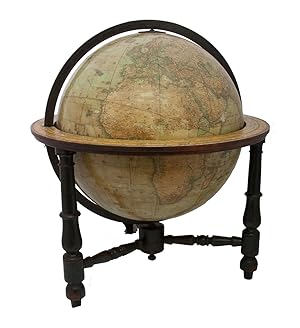
Only recorded copy of the 1848 edition (preceded only by one recorded copy of 1846 edition) of Malby's 18 inch (45.5 cm) terrestrial globe, the largest he engraved and much rarer than his 12 inch globe. It shows small pieces of the Antarctic coast, noting sightings and explorations from 1831 to 1841. In Africa it shows Lake "Nya…ssi", discovered by Candido José da Costa Cardoso in 1846, but most of equatorial Africa and the Congo remain uncharted territory. "Oregon", officially made a United States territory in 1848, shows the boundary with "British America" agreed at the 1846 Oregon treaty. Alaska is still "Russian America. Texas is part of the United States, as are California and most of Arizona. The Revolution of 1848 has not yet affected the boundaries of the Austrian Empire. "Debai" (Dubai) is shown on the Gulf coast, only 15 years after the al-Maktoum dynasty took charge of it in 1833.The globe seems to be intended especially for navigational use, with not only a grid of parallels and meridians, but also the irregular curved lines indicating the variation of magnetic from geographic north ("isogones"). Malby seems to be the first and almost the only globe maker to show them.The horizon ring and globe have a dozen small cracks repaired and a few small gaps in the surface image, some repaired, but are otherwise in good condition. Extremely rare and lovely large globe.l Cf. British Library on-line cat. BLL01013005847; Dekker, GLB0081; Dunn & Wallis, British globes up to 1850 (1999) 209 & 443; World in your hands (Rudolph Schmidt coll.) 7.12 & 7.13; Yonge, Early globes (1968), p. 46. In a contemporary wooden stand with 3 turned legs supporting the horizon ring, and 3 turned stretchers with a cylindrical centrepiece with a knob on the underside. Further with a contemporary brass hour circle and a slightly later iron meridian ring (and probably the axis pivots). An engraved terrestrial globe with 12 gores and 2 polar caps over a plaster-covered core, and the engraved horizon ring on the wooden stand, all coloured by a contemporary hand. Diameter: 45.5 cm (18 inch), height in stand: 64.5 cm.
 More images
Published by Roztok
Seller: Chaco 4ever Books, Montevideo, MO, UruguayChaco 4ever Books
Contact seller5-star sellerCondition: Used - Very good
US$ 3,800.00
US$ 31.50 shippingShips from Uruguay to U.S.A.Quantity: 1 available
wrappers. Condition: Good. [late 19th century]. Brass meridian, wooden equatorial line, painted hardwood supports, three legs centered with compass between feet, 16 inches tall.
 More images
Published by [London], Malby & Co. (engraved by Chas. Malby), 1 January 1848. 1848
- Map
Seller: Antiquariat INLIBRIS Gilhofer Nfg. GmbH, Vienna, A, AustriaAntiquariat INLIBRIS Gilhofer Nfg. GmbH
Contact seller5-star sellerCondition: Used
US$ 41,721.81
US$ 34.72 shippingShips from Austria to U.S.A.Quantity: 1 available
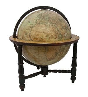
Diameter: 45.5 cms (18 inch), height in stand: 64.5 cm. An engraved terrestrial globe with 12 gores and 2 polar caps over a plaster-covered core, and the engraved horizon ring on the wooden stand, all coloured by a contemporary hand. In a contemporary wooden stand with 3 turned legs supporting the horizon ring, and 3 turned stre…tchers with a cylindrical centrepiece with a knob on the underside. Further with a contemporary brass hour circle and a slightly later iron meridian ring (and probably the axis pivots). Only recorded copy of the 1848 edition (preceded only by one recorded copy of the 1846 edition) of Malby's 18 inch (45.5 cms) terrestrial globe, the largest he engraved and much rarer than his 12 inch globe. "Debai" (Dubai) is shown on the Gulf coast, only 15 years after the al-Maktoum dynasty took charge of it in 1833. The globe seems to be intended especially for navigational use, with not only a grid of parallels and meridians (with the prime meridian through Greenwich), but also the irregular curved lines indicating the variation of magnetic from geographic north ("isogones"), at 5 degree intervals. From these one can clearly see where the magnetic poles were. Malby seems to be the first and almost the only globe maker to show them. The engraver signed the present globe "Chas. Malby" and signed the 12 inch globe of 1845 described by Dekker "C. I. Malby". He must therefore have been Charles Isaac Malby (1816-post 1868). Thomas Malby, Charles's brother, first set up as a globe publisher around 1839 and was trading as Malby & Co by 1841. Charles may have engraved nearly all of his globes. The earliest Malby globe known to survive is dated 1842, but his earliest recorded 18 inch globes are a pair at the Mariners' Museum in Virginia: the celestial globe dated 1843 and the terrestrial globe dated 1846. The Austrian National Library has an 18 inch Malby terrestrial globe dated 1850, but we find no further example until 1872. The present 1848 example appears to be unique. The horizon ring has an owner's stamp on the printed surface, nearly due east, apparently a coat of arms in a wreath, but difficult to make out. The horizon ring and globe have a dozen small cracks repaired and a few small gaps in the surface image, some repaired, but are otherwise in good condition. Extremely rare and lovely large globe, with the fascinating and unusual graphic presentation of geomagnetism. - Cf. British Library online cat. BLL01013005847; Dekker, GLB0081; Dunn & Wallis, British globes up to 1850 (1999) 209 & 443; World in your hands (Rudolph Schmidt coll.) 7.12 & 7.13; Yonge, Early globes (1968), p. 46.


