Texas Map (49 results)

Published by Texas Centennial Central Exposition, Alco Gravure, Inc.],, [Dallas, TX]: 1936
- First Edition
Seller: Zephyr Used & Rare Books, Vancouver, WA, U.S.A.Zephyr Used & Rare Books
Contact seller5-star seller4to. [12 pp (unpaginated).] triptych, which folds out to text & photos, and then large pictorial map on verso of the Centennial Exposition sized 24 x 18 in. Self-printed softcovers, featuring Art Deco cover art in sepia of the Exposition (minor shelfwear, slight creasing), still VG copy. First edition of this uncommon souvenir m…ap to the 1936 Texas Centennial Exposition, held to commemorate the 100th Anniversary of Texan Independence, and after Dallas had won the right to host the Exposition over Houston & San Antonio because their leadership team was superior. The Exposition coordinated with the WPA to erect permanent buildings, monuments, statues and grave markers, and the Hall of State was part of the funding. Billed as the first World's Fair in the Southwest, the Cavalcade of Texas and The Hall of Negro Life proved to be two of the most popular attractions. The unofficial Fort Worth Texas Centennial was a competing attraction produced by Billy Rose, with nearly 1 million attendees, while the Dallas Texas Centennial achieved nearly 6.4 million visitors. Worldcat locates 5 copies (Baylor, SMU, Hardin-Simmons, UT Austin, Yale).

Published by S. Augustus Mitchell, Jr., New York 1860
- Map
Seller: Main Street Fine Books & Mss, ABAA, Galena, IL, U.S.A.Main Street Fine Books & Mss, ABAA
Contact seller5-star sellerFolio (15¼" X 12¼", image area 13¼" X 10 3/4"). Hand colored. Very good. Light age toning. Nicely, boldly colored map of this oversize state, from the 1864 edition of "Mitchell's New General Atlas, Containing Maps of the Various Countries of the World, Plans of Cities, Etc." Inset at lower left shows "Galveston Bay and Vicinity,…" and the large Native American turf "Young Territory" and "Bexar Territory" are properly outlined. Attractively colored, with bold decorative border.
 More images
Published by Woodward, Tiernan & Hale; St. Louis; pp.; Wraps; VG; nc/1878 1878
- Map
Seller: Watermark West Rare Books, Wichita, KS, U.S.A.Watermark West Rare Books
Contact seller4-star sellerCondition: Used - Very good
US$ 600.00
US$ 8.00 shippingShips within U.S.A.Quantity: 1 available
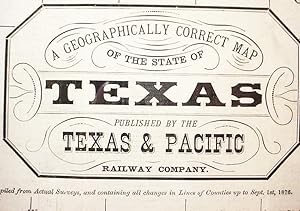
No Binding. Condition: Very Good. _____Large sheet, 20 x 21.25", folded to 18 panels._____ All the folds are tender, most have started at least at the edges._____ Some have archival reinforcements on the text side._____ There are two 1/2" holes, at interior corners of the folds._____ One is at (roughly) Del Rio, the other east o…f Seguin and SE of Lockhart. _____ The text side is occupied with four panels of time tables in effect from June 1, 1878._____ Five panels are devoted to the article "Texas / The / Garden State of America." Six more are given over to "Northern Texas! / Its Soil, climate, Products and Resources." The final panel is an "Extract / from the / Constitution of the State of Texas / Relating to the Homesteads of Families.". _____ The entire interior is "A Geographically Correct Map / of the State of / Texas / Published by the / Texas & Pacific / Railway Company."_____ Printed in shades of green, it depicts counties, creeks and landmarks throughout the state and most of the Indian Territory._____ The route of the T&P is shown throughout Texas, though the western 3/4 appears to be "Projected.". _____ The map side has a rubber stamp from the Arkansas & Texas Land & Passenger Agency in Cincinnati._____ There is a smaller stamp on the text side from an Ohio land agent. _____.

- Softcover
- Map
Seller: Geographicus Rare Antique Maps, Brooklyn, NY, U.S.A.Geographicus Rare Antique Maps
Contact seller4-star sellerSoft cover. Good. Binding tight but restored, retaining original gilt stamped spine and blind-stamped boards. Interior, light foxing. Both plates present. Pencil markings. Manuscript note tipped into front. Library stamp on page 45. Map present but detached. A few minor fold mends, and small repaired tear where originally attach…ed to book. Lower right margin extended. Size noted refers to map. Book 7.5 x 4.75 x 1 inches. Size 8.5 x 10.5 Inches. A most significant book and map of Texas, being the 1836 second 'and better' edition of Amos Andrew Parker's Trip to the West and Texas. . This work is considered essential Texana, offering not only one of the earliest maps of the Republic of Texas, but also one of the first illustrations of the Lone Star flag of Texas, and one of the best early descriptions of the Texan Revolution. The map is significant, revealing early land grants throughout the new republic. It also bears an interesting manuscript dedication referencing the Mexican Revolution (1910 - 1920). Streeter Describes the Map Map historian Streeter included a description of this work in his important catalog (1172), This includes a rather pedestrian account of a sightseeing journey of a little over a month in December 1834, from the Sabine to the Colorado, then back to San Felipe and Brazoria. In the account are around forty pages with the caption heading, 'General View of Texas.' The 'Brief Sketch of the Texian War' in the title of the second edition is given in an appendix, which tells the story in popular form to the capture of Santa Anna at San Jacinto. Parker's entire journey, as outlined on the title page, was to gather information on the regions visited. Even though quite prosaic in style, it has for a little-known new country like Texas the interest that is present in any early contemporary account of travels. Parker, a graduate of the University of Vermont in 1813, was a New Hampshire lawyer and judge, and an occasional author. There is a brief account of him in the General Catalogue of the University of Vermont, Burlington, 1901. The Map The present edition bears a small but significant map of Texas closely based on the Bradford map of 1835. Although undated and unattributed, this map too is likely a Bradford, most likely an earlier state. The Bradford map from the atlas embraces slightly more territory to the south. Here Camargo, El Rincon, and Laguna de Santander, which are shown on the atlas map, do not appear, suggesting this is an earlier plate. Another variation, the atlas map features longitude from Washington, while this map bases longitude on the London Prime Meridian - suggesting again that this an earlier plate, possibly intended as a proof for the atlas, not used, then resurrected here. As Streeter notes, this map is rare, and appears in only a few examples of the second edition of Parker's narrative. In his own words, The map is a rare and variant feature of this second edition. One is fortunate to find a map in this book at all (only five copies of the book have appeared at auction going back to 1975, two lacked the map, and one had only a portion of the map), possibly indicating that the addition of a map to the second edition was an afterthought. The last copy at auction was at Sotheby's London on November 18, 2004 (Lot 358), where it fetched £6,200 ($11,532). The map is among the early maps of the Republic of Texas in a book, and it is based on Bradford's 1835 map of Texas published in his atlas (the first Texas map to appear in an atlas). We have seen three different maps with this book: (1) the Dearborn map described in Streeter's 1172A, (2) an 1836 issue of the important Mitchell-Young map of Texas (see Streeter 1178), and (3) the present map, which is copied very closely from the 1835 Bradford map of Texas. That map was thus a hastily added addendum to the second edition, the publisher incorporating what was obtainable and improvising where necessary. Of the three maps occasionally found in variations.
 More images
Johnstons' Commercial Chart of the World on Mercators Projection from the latest and Best Authorities Containing the Position of Every Place of Commercial Importance, Shhowing the Princial Currents of hte Ocean with their Direction and Rate of Progress. With an Enlarged Map of Central Europe Showing the Railway Communication between the Different Countries, and Distinguishing the States which compose the German Customs Union.
1849 Johnston Library Wall Map of the World w/Texas at fullest
- Hardcover
- First Edition
- Map
Seller: Geographicus Rare Antique Maps, Brooklyn, NY, U.S.A.Geographicus Rare Antique Maps
Contact seller4-star sellerHardcover. 1st Edition. Very good. Some offsetting. Wear and toning on some old fold lines. Dissected and laid on original linen, in original stamped leather binder. Stable. Size 56.25 x 72.75 Inches. A very impressive large scale first edition example A. K. Johnston's 1849 map of the world made for trade and commerce. Issued at… the height of the British Empire, the map is appropriately centered on the London meridian. The focus is trade and commerce, with global shipping lanes and times noted throughout, as well as caravan routes through Africa and Asia, wagon routes through North America, and steam packet routes. A large inset in the lower right focuses on the railways of central Europe and, interestingly, the German Customs Union. In terms of size, detail, style, and composition, we surmise Johnston must have issued this map to compete with the lucrative Teesdale franchise, who had been issuing similar large scale 'commerce' maps since 1837. A Closer Look The map has much to offer, not only in terms of fine engraving, color, and grandiosity, but also for its superlative detail. North America and the United States conforms to the situation at the end of the Mexican American War (1846 - 1849). Texas is illustrated at its fullest, with boundaries extending well into modern-day Wyoming and west as far as Santa Fe. Further west, Sutter's Fort is noted, suggesting knowledge of the California gold discovery, but when this map was engraved, the mad rush had yet to occur. Instead, the focus is the fur trade, including overland and shipping routes bypassing San Francisco for Astoria - then the major hub of trade on the west coast. This area was formally ceded to the United States in 1846 - ending the Oregon Question, but in 1849, busy Columbia River ports remained just as important to British and Canadian trappers operating out of British Columbia, as to Americans in Oregon Territory. When this map was issued, Africa remained explored only along the coast and major river systems, with much of the interior unknown. Nonetheless, Johnston makes a great effort to map trade routes throughout the Sahara, including major routes from centers in Fezzan, Morocco. and Tripoli to oases and salt mines in the southern desert. He names individual oases, holy sites, and caravan stops with greater accuracy than we have seen in any comparable world map. Further south, ghosted in river systems offer the first hints of Lake Malawi - perhaps from local reports? In Asia, attention is lavished on India and China, both of vital importance to British global trade. While India is a well-mapped mosaic of kingdoms and protectorates, China is a massive green block extending from Tartary to Sakhalin, including all of Korea, Manchuria, Mongolia, and Taiwan. Shipping routes focus on connections between Bombay, Singapore, Hong Kong, Guangzhou, and the Pearl River Delta. Trans-Pacific routes include an 'American Proposed Route' linking Astoria with Hong Kong. Railroad commerce dominates Europe. There is even a large inset focusing on central Europe and in particular the German Customs Union. The Zollverein, as the Customs Union is more commonly known, was organized in 1833 as a coalition of German states formed to manage tariffs and economic policies. By 1866, it included most German states. The Zollverein was the first instance of independent states consummating a full economic union without the simultaneous creation of a political union. This would have been particularly significant as this map went to the presses. The 1848 Springtime of Nations Revolutions rocked Germany and there was active talk of a Pan-German economic and political union, which had the potential to transform Germany into an powerhouse capable of undermining British trade. Publication History and Census This is the first edition, published and engraved in Edinburgh by W. and A. K. Johnston. It was co-published in Glasgow by Hames Lumsden and Son, and in London by T. W. Saunders. We have noted later editions, and some w.

Map of the United States of America, the British Provinces, Mexico, the West Indies, and Central America: with part of New Granada and Venezuela.
1849 Colton Map of United States (Texas at Fullest) (First Edition) (Gold Rush)
- Hardcover
- First Edition
- Map
Seller: Geographicus Rare Antique Maps, Brooklyn, NY, U.S.A.Geographicus Rare Antique Maps
Contact seller4-star sellerCondition: Used
US$ 11,200.00
US$ 17.00 shippingShips within U.S.A.Quantity: 1 available
Hardcover. 1st Edition. Very good, near fine example. Dissected and mounted on linen in 32 panels. Original linen. Size 33 x 40 Inches. This is J. H. Colton's first edition 1849 map of the United States on the cusp of the California Gold Rush, in a fine example. The map depicts the United States immediately following the 1848 Tr…eaty of Guadeloupe Hidalgo, including Texas at its largest and the Mexican Cession of Upper California (or New California). A Closer Look Coverage focuses on the United States, extending from coast to coast, but also includes Mexico, Central America, and the West Indies. Texas is rendered at its fullest extent as a state with its 1845 - 1849 borders, including the stovepipe northern panhandle. Alternative Texas borders and claims within the new state are also noted. Nebraska, too, is illustrated at its fullest extent, reaching northwards as far as the Canadian border. Cartography in California remains primitive, but the Gold Region on the Sacramento River around the town of New Helvetia, the original name of John Sutter's settlement, is noted. Possibly this map's most interesting feature is its thorough presentation of Texas - a topic no doubt much on the minds of Colton's educated American clientele. The map not only illustrates the borders under which Texas joined the Union in 1845 but also various alternative and conflicting borders actively debated during and after the Mexican-American War until their ultimate resolution in the Compromise of 1850. These include highlights in blue showing Mexican claims as far northeast as the Nueces River - a major catalyst of the Mexican-American War. Those who argued for a border at the Nueces River also argued that the border should continue north along the Guadeloupe Mountains roughly to the Red River Valley. Still other borders recognize old Mexican distinctions relating to the governance of Santa Fe. These were eventually resolved by the 1848 Treaty of Guadeloupe-Hidalgo and the subsequent Compromise of 1850, which firmly fixed the borders of Texas much as they are today. The United States' other new acquisition, Upper California, is presented in a primitive form predating substantive updates derived from Fremont's explorations. Sacramento still appears as New Helvetia, the name John Sutter gave to his grant before discovering gold in the region. The cartography along the Sacramento River and its tributaries remains vague and incomplete, a fact which would soon change as explorers and gold prospectors flooded into the region. In the Great Basin, little is known. The subsequent second edition of this map updates this region considerably, adding Fremont's Route along the Humboldt River and several new mountain ranges. Another point of interest in this region is a note at the convergence of the Colorado and St. John's Rivers that reads 'Supposed Residence of the Aztecs in the 12th century.' This references the German naturalist Alexander von Humboldt's analysis of codices and other indigenous records regarding the 12th-century Aztec migration into the Mexico Valley from somewhere far to the north. Also noted in modern-day New Mexico are the Ruins of Gran Quivira. These extensive Anasazi ruins were plundered by Coronado and settled by Spanish missionaries in the 16th century. They are often associated with legends of the apocryphal Seven Cities of Gold sought by many early conquistadors. Colton has also noted several routes related to the American Westward Migration. These include the Oregon Trail, with distances noted from Westport Landing, Missouri. The Santa Fe Route, which also started from Westport Landing, appears farther south. In addition to migrant routes, the map details military routes, including those taken by General Kearney in 1846, John C. Fremont, and General Wool, among others. Throughout indigenous American Indian Nations are noted. Insets and Decorative Elements An inset has been added to the lower left detailing the Atlantic Ocean and several trans-Atlantic shipping r.

- Map
Seller: Geographicus Rare Antique Maps, Brooklyn, NY, U.S.A.Geographicus Rare Antique Maps
Contact seller4-star sellerGood. Wear and toning along original fold lines. Size 15.75 x 20 Inches. This is a c. 1968 Bureau of Economic Geology map of the Big Bend Region, Texas. Coverage embraces the entirety of Big Bend National Park and environs. Mountains, ridges, peaks, and other geological features are illustrated. A dotted and dashed line marks th…e boundary of Big Bend National Park (although it is unlabeled). Roads appear as thick black lines, while thinner black lines mark geological faults. Big Bend National Park Big Bend National Park opened to visitors on July 1, 1944, and is the largest protected area of Chihuahuan Desert ecology and topography in the United States. Originally established in 1933 as Texas Canyons State Park, the United States Congress began the process of acquiring the land from Texas in 1935. Texas deeded the land to the federal government on June 12, 1944. Big Bend National Park is the only national park in the United States to contain an entire mountain range: the Chisos Mountains. The Park also contains habitats for hundreds of animal and plant species, as well as 10,000-year-old archaeological sites, dinosaur fossils, and 118 miles of the U.S.-Mexico border. Publication History and Census This map was created by the Bureau of Economic Geology c. 1968 and published in Ross A. Maxwell's The Big Bend of the Rio Grande: A Guide to the Rocks, Geologic History, and Settlers of the Area of Big Bend National Park . by the Bureau in 1968. Two examples of the present map are cataloged in OCLC and are part of the collections at Memorial University/Newfoundland, Elizabeth II and Sul Ross State University in Alpine, Texas. The guide in which it was published is well represented in institutional collections. References: OCLC 1053980266.

- Map
Seller: Geographicus Rare Antique Maps, Brooklyn, NY, U.S.A.Geographicus Rare Antique Maps
Contact seller4-star sellerVery good. Even overall toning. Size 23.5 x 20.5 Inches. This is an 1841 Carl Ferdinand Weiland map of North America including the Republic of Texas. A Closer Look An ephemeral Republic of Texas that predates Texan claims in New Mexico which would give rise to the 'Stovepipe' configuration is illustrated here. The United States…stretches from Atlantic to Pacific, though the border between the U.S. and Mexico is depicted at the 42nd parallel. As this map predates the Mexican-American War, this border is not unusual, however it means that most of what constitutes the modern American Southwest is still a part of Mexico. Also, the northern border of the United States contains a gap, likely reflecting the still undecided dispute between Britain and the United States over what is now British Columbia, known as the 54°40' dispute. The Geography of the Republic of Texas The geography of Texas illustrated here predates Texas's claims to New Mexico, as stated above. Later, the Republic of Texas would claim to all land east of the Rio Grande, which extended north to modern-day Wyoming, to the U.S. border, which at that time was the Arkansas River. The Republic would exist for another five years, until Texas was formally admitted to the United States in December 1845 and ceded its sovereignty to the United States on February 19, 1846. The annexation of Texas led to a deterioration of foreign relations between the United States and Mexico due to an unresolved border dispute between Texas and Mexico and directly led to the Mexican-American War. Publication History This map was created and published by Carl Ferdinand Weiland in 1841. It was published in Weiland's Allgemeiner Hand Atlas and a digitized example is part of the David Rumsey Map Collection. References: Rumsey 9074.064.

- Map
Seller: Geographicus Rare Antique Maps, Brooklyn, NY, U.S.A.Geographicus Rare Antique Maps
Contact seller4-star sellerVery good. Light toning. Rust stain to lower left corner; one small mended hole not impacting printed image. Size 15 x 15 Inches. This is a 1954 'Map-Nap' of the state of Texas, featuring a map of the United States from the perspective of a Texan. A Closer Look This colorful map, printed on a napkin, marks principal cities and i…s decorated pictorially with icons of the via Texana: The Alamo, the monument of San Jacinto, spouting oil wells, and other such elements. The 'Map of Texas, U.S.A.,' in particular, features an array of classically Texan attractions: the largest flying school, the largest garden, the biggest ranch, the wildest animals, the largest salt bed, the most beautiful girls, the tallest pines, the biggest jackrabbits. And so on. A list of 'Interesting Facts About Texas' offers information on the state's size, population, produce, and industry. (For example, the reader learns that Texas is 'The largest state in the Union. approximately 1/12the the area of the entire United States.') A Full Series? Beach Products appears to have produced this piece of Texana as part of a series of 'State Map-Naps.' We are aware of examples not only dedicated to Texas, but also for Florida, Indiana, Michigan, California, North Dakota, and Minnesota. While it would be reasonable to assume a plan to produce a 'Map Nap' for every state in the Union, relatively few have appeared on the market, and it may be that the project was cut short. Publication History and Census This map was printed by Beach Products Inc. of Kalamazoo, Michigan, having been copyrighted in 1954. (Beach Products was a paper goods company less known for their maps and more for their napkins.) We see no examples of the Texas Map-Nap in OCLC, but there is a single listing for another in the series (Michigan: Water Wonderland) in the collection of the Library of Michigan.

Brashear City (Louisianie) / Nashville (Tennessee) / Galveston (Texas).
1890 Vorzet Map of Nashville, Tennessee, Galveston, Texas, and Barshear City, Louisiana
- Map
Seller: Geographicus Rare Antique Maps, Brooklyn, NY, U.S.A.Geographicus Rare Antique Maps
Contact seller4-star sellerVery good. Mounted on linen. Size 13.75 x 10 Inches. This sheet, including three detailed maps, was prepared by Ernest Dumas-Vorzet for the 1890 work Histoire de la Guerre Civile en Amérique . It maps battles at Nashville, Galveston, and Brashear City, three important battles in the Western and Trans-Mississippi Theaters of the…U.S. Civil War. A Closer Look Despite their different subjects and scales, all three maps emphasize the topography and terrain of the battlefields in question while also noting roads, railways, settlements, waterways, shoals, and other terrestrial and maritime features. Galveston was the site of two battles: a confused but ultimately bloodless Union capture of the city in October 1862 and a successful Confederate counter-attack on New Year's Day 1863. The Battle of Brashear City (now Morgan City) on June 22 - 23, 1863, was, like the first engagement at Galveston, fairly unusual. In this case, a small Confederate force snuck to the outskirts of the city at night. It attacked the much larger Union garrison the next morning, taking them by surprise and capturing hundreds of enemy soldiers and weapons with very light casualties. But the Battle of Nashville in 1864 was the most influential of the three depicted here. After falling to Union troops in February 1862, Nashville had been the target of Confederate hopes for a revival in the Western Theater, which had gone quite badly for them. Late in the war, in mid-December 1864, as Sherman was completing his 'March to the Sea,' Confederate General John Bell Hood tried to draw out Union forces at Nashville in a desperate attempt to turn the tide of the war. However, the Union forces were overwhelming and routed Hood's army, scoring one of the more lopsided Union victories of the conflict and effectively ending the war in the Western Theater. Publication History and Census This map was drafted by Ernest Dumas-Vorzet, engraved by Louis Wuhrer, printed by Becquet, and published by Michel Lévy in Paris for the 1890 French edition of Philippe d'Orléans' Histoire de la Guerre Civile en Amérique . The atlas supplement, of which this map was part, was issued only with the 1890 French publication and not included in any of the earlier English editions. The entire work, in this edition, is uncommon in institutional collections, with only 3 being identified in OCLC, and is scarce to the market. Most examples lack the atlas, which in OCLC appears only at the Boston Athenaeum. Very little market history. References: LC Civil War Maps (2nd ed.), 80. OCLC (one sheet cataloged three times) 877854532, 877854531, 877854598.

- Map
Seller: Geographicus Rare Antique Maps, Brooklyn, NY, U.S.A.Geographicus Rare Antique Maps
Contact seller4-star sellerVery good. Even toning. Repairs and reinforcements on the verso to marginal tears. Small hole at top-center in the plot marked 'No. 23 Archibald S. White.' Handwritten annotations in pencil provide updated or corrected information on property ownership. Size 23 x 19.75 Inches. A rare 1880 plat map of Jackson County, Texas, produ…ced by the Texas General Land Office and printed (lithographed) by August Gast. It depicts the county on the eve of an important transformation brought by the railroad. A Closer Look Jackson County is situated midway down the Texas coast, about midway between Houston and Corpus Christi. Much of the county originally consisted of coastal prairies and the rivers and bays seen here provide access to the Gulf of Mexico. By the time this map was produced, Jackson had been in existence for nearly 50 years, having been founded in 1836 (named for Andrew Jackson) as a municipality within Mexican Texas and then as one of the original counties of the independent Republic of Texas. As such, it was an early site of settlement for members of the 'Old Three Hundred' families who purchased parcels of land from Stephen Austin's land grant in the early 1820s. As with the wider region around the old Spanish Presidio La Bahía, Jackson County had originally been home primarily to Karankawa people, who had a difficult relationship with the Spanish before being driven out of the area by settlers in the 1820s - 1850s. During the Texas Revolution, many residents fled and their farms were burned by Santa Anna's troops. Compared to a contemporary map of neighboring Calhoun County recently sold by us (CalhounCounty-texasglo-1879), there are more Anglos and less Tejanos among the landowners of Jackson County. As in Calhoun County, there does appear to have been noticeable but not absolute spatial segregation between the two groups. In this case, Tejanos mostly reside west of the Lavaca River and Anglos to the east. Unsurprisingly, some landowners owned property in both counties. Notable among the landholders indicated here are Texas founding fathers Stephen Austin and Sam Houston, both long deceased by the time this map was published, but their property had presumably been retained by descendants. Though no railroad existed at this time in the county, the International-Great Northern Railroad owned tracts of land in the county. However, it was another company, the New York, Texas and Mexican Railway, that first built a railroad there. In the mid-19th century, Texana emerged as the main town in the county, but the overall population remained small and agrarian, with as much as one-half of the county's population being enslaved, tasked with growing cotton and sugarcane. In the years immediately following this map's publication, the Italian-born railroad entrepreneur Joseph (Guiseppe) Telfener built the New York, Texas and Mexican Railway through Jackson County. The residents of Texana were ambivalent about the project because they thought it would threaten the town's maritime shipping, so a station was built to the west, closer to the Lavaca River. Edna, named for one of Telfener's daughters, quickly outgrew Texana as a result, and was made the county seat in 1883. By 1884, Texana was a virtual ghost town and today only exists as a historical site within Edna. Publication History and Census This map was prepared by the Texas General Land Office and printed by August Gast in 1880. We note it among the holdings of the University of Houston, the Library of Congress, and Texas A and M University, and it has no known history on the market. A later edition was published in 1896 and is similarly scarce. References: OCLC 171015562, 796918326 (1896 edition).

- Map
Seller: Geographicus Rare Antique Maps, Brooklyn, NY, U.S.A.Geographicus Rare Antique Maps
Contact seller4-star sellerGood. Wear along original fold lines. Small areas of loss at fold intersections and along original fold lines. Information and printed photographs on verso. Size 25.5 x 31.25 Inches. This is a 1941 Robert Martin Stene and Texas Highway Department highway map of Texas. Texas' extensive highway network is illustrated in detail. A…Closer Look The map informs users of different road surfaces, varying from pavement to all-weather gravel and shell surfaced roads, to improved and unimproved dirt roads. Roads that are not maintained by the highway department even appear and are illustrated by two parallel dashed lines. Green highlights national forests, state parks, and, paradoxically, oil and gas fields. Thirteen inset maps focus on important metropolitan areas, including Dallas, Fort Worth, Austin, Amarillo, El Paso, and Waco. An alphabetic index of Texas towns occupies the upper right outside the map's border and provides users with each town's location using the map's grid index and their 1940 population. Verso Content Twenty-seven printed photographs adorn the verso and a numerical index informs users what each one represents and many provide short captions. Information about Texas state parks and highway signs appear as well. Publication History and Census This map was drawn by Robert Martin Stene and published by the Texas Highway Department in 1941. Our research indicates that the Texas Highway Department published at least three highway maps per year, a Spring Edition, a Summer Edition, and an Autumn Edition, each of which would be updated with the most recent information. The present example is the 1941 Summer Edition and was corrected to May 1, 1941. Numerous Texas highway maps by Robert Martin Stene are cataloged in OCLC, but none correspond with the present 1941 Summer Edition.

- First Edition
- Map
Seller: Geographicus Rare Antique Maps, Brooklyn, NY, U.S.A.Geographicus Rare Antique Maps
Contact seller4-star seller1st Edition. Good. Minor soiling and wear on old fold lines. Slight loss near title. Stabilized. Size 21.75 x 32.5 Inches. A colorful 1978 pictorial map of Houston, Texas, issued by Image Graphics to promote Astroworld, an immersive sports-focused theme park. A Closer Look Centered on downtown Houston, with its many iconic skysc…rapers recognizable, the map broadly covers the metropolitan area, extending from Houston International to Hobby Airport. Astroworld, Astro Village, and the Astrodome appear just below and to the left of center. At the lower right, the view shows Houston's sports teams: the Astros, Rockets, Oilers, Hurricanes, and Aeros. Throughout, local businesses and landmarks are noted. Astroworld Astroworld was an amusement park located in Houston, Texas. It was founded in 1968 by local entrepreneur Judge Roy Hofheinz. The park was intended to complement the nearby Houston Astrodome, thus offering an immersive sports-themed entertainment experience. Astroworld featured rides, attractions, and themed areas, quickly becoming a beloved family destination. Over the years, the park underwent numerous expansions and renovations, introducing iconic rides such as the Texas Cyclone and Greased Lightnin'. Despite its popularity, Astroworld faced financial challenges and changing ownership, ultimately being acquired by Six Flags in 1978. The park permanently closed on October 30, 2005, due to rising property values and financial struggles. Publication History and Census This map was designed by Image Graphics of Arlington, Texas. It is one of several maps of Houston and Arlington copyrighted by that firm in the 1970s. This is the first edition. Rights to the map were acquired by the Canadian pictorial map publisher Archar in 1979 when a second edition bearing their imprint appeared. Scarce. We see an example at the University of Texas at Arlington. References: OCLC 1259567242.

- Map
Seller: Geographicus Rare Antique Maps, Brooklyn, NY, U.S.A.Geographicus Rare Antique Maps
Contact seller4-star sellerGood. Soiling at right. Adhesive residue and crimped corner in top-right margin. Size 15.5 x 17.25 Inches. A rare 1912 plat map of Midfield, Texas and surrounding areas produced by F. P. Lund. Among other features, it reveals the extensive landholdings of the International - Great Northern Railroad, the result of an unrealized p…lan to connect the town with points further east and north. A Closer Look Though focusing on the town of Midfield (also as Midfields, as at bottom-right), coverage extends over large portions of Matagorda and Wharton Counties. Individual landholders are named or at least abbreviated where space permits, along with information on the size of their plots. The town of Midfield sits towards bottom-center. Neighboring counties, rivers, and creeks, are also indicated. Midfield Junction Two rail lines, the Southern Pacific and St. Louis, Brownsville and Mexico Railway, intersect at bottom. However, much of the land around Midfield, if not an absolute majority in Matagorda County, is owned by the International - Great Northern Railroad. Beginning in Longview, near the Arkansas-Louisiana-Texas border in 1873, the line extended southwards continuously, eventually reaching Austin, San Antonio, and Laredo. It was a prolific landholder throughout Texas, with plans to build extensions and branch lines to its main route. In the early 20th century, the railroad had planned to extend to nearby Bay City, east of Midfield, and presumably on to Midfield itself, but was ruined by the Great Panic of 1907. It was sold in 1908 and reorganized in 1911 with a nearly identical name but was bankrupted again a decade later, never having reached Bay City, let alone Midfield. Publication History and Census This map was prepared by F.P. Lund in 1912. In addition to surveying work, Midfield resident F.P. Lund appears to have been a professor, agricultural expert, and ardent evangelist who operated a Sunday school, though concrete details of his life and work are elusive. The map is not cataloged among the holdings of any institution and has no known history on the market.

- Map
Seller: Geographicus Rare Antique Maps, Brooklyn, NY, U.S.A.Geographicus Rare Antique Maps
Contact seller4-star sellerGood. Wear and toning along original fold lines. Small areas of infill along original fold lines and at fold intersections. Size 32.75 x 34.75 Inches. This is a 1954 Texas General Land Office and Eltea Armstrong map of Texas. The map features a portrait of Bascom Giles at the height of his power as head of the Texas Land Office,… and just months before his fall in the Veterans Land Board Scandal. Austin, Dallas, Fort Worth, Abilene, Houston, and San Antonio, are emphasized by 'street grids' relating their relative size. Green areas highlight national forests and Big Bend National Park. Mountains in West Texas are illustrated pictorially. State parks and forests are indicated by green pine trees. Bascom Giles and The Veterans Land Board Scandal This map was published in 1954, likely months before the Veterans Land Board Scandal broke in November. Bascom Giles (the Texas General Land Office Commissioner) and several other members of the GLO used their influence to convince mostly illiterate veterans to apply to buy land under the Veterans Land Act. Giles, other GLO officers, and their businessmen associates would then pocket the money. Many of the veterans who purchased land were not even aware of the fact. The fraud spread to nine counties in south Texas. Bascom Giles (the Texas General Land Office Commissioner) and several other members of the GLO were charged with fraud and conspiracy to defraud veterans. Giles served three years in the Texas State Penitentiary and holds the distinction of being the first state elected official to go to prison for crimes committed while in office. Publication History and Census This map was created by Eltea Armstrong and published by the Texas General Land Office in 1954 during the tenure of Bascom Giles as commissioner. We note seven examples cataloged in OCLC which are part of the collections at Yale University, the University of Texas at Arlington, Baylor University, the Austin Public Library, Hardin-Simmons University, the University of Texas at El Paso, and the University of Arizona. An example is also part of the map collection of the Texas General Land Office. The map never attained wide circulation, likely due to most copies being destroyed after the scandal. References: OCLC 137370942.

- Map
Seller: Geographicus Rare Antique Maps, Brooklyn, NY, U.S.A.Geographicus Rare Antique Maps
Contact seller4-star sellerVery good. Light foxing and slight surface scuffing. Size 23.25 x 33.5 Inches. An unrecorded 1982 pictorial map of Texas history drawn by Bill Car and issued by the Broadway set designer Peter Wolf. A Closer Look The map pays respectful homage to all things Texas. Texas dominates the image, with its northern stovepipe extending…into the map's decorative border. Throughout, important sites in Texas history are noted, along with historical annotations. Surrounding the map are illustrations of important Texas figures, with Stephen F. Austin, Sam Houston, William B. Travis, and Davie Crockett taking pride of place. Additionally, the map illustrates historical events ranging from the Franciscan Mission, to the Alamo, to the formation of the Texas Rangers, to Texas joining the United States. It features a decorative border inherited from a 19th-century map design. An inner border features historical cattle brands - we recognize a few, including King Ranch. Publication History and Census This map was drawn by Bill Car, designed by Peter Wolf, and published in 1982 by Peter Wolf Concepts. Historical research and art direction was done by James Frazer. We do not see examples recorded in any institutional collection and note very limited market history. This example came from Wolf's estate. His archives are being donated to Southern Methodist University. The archives contain several examples of this map, but most were heavily damaged in storage. Perhaps 25 surviving examples are known.

- Map
Seller: Geographicus Rare Antique Maps, Brooklyn, NY, U.S.A.Geographicus Rare Antique Maps
Contact seller4-star sellerGood. Light foxing. Toning upper left. Size 23.25 x 33.5 Inches. An unrecorded 1982 pictorial map of Texas history drawn by Bill Car and issued by the Broadway set designer Peter Wolf. A Closer Look The map pays respectful homage to all things Texas. Texas dominates the image, with its northern stovepipe extending into the map's… decorative border. Throughout, important sites in Texas history are noted, along with historical annotations. Surrounding the map are illustrations of important Texas figures, with Stephen F. Austin, Sam Houston, William B. Travis, and Davie Crockett taking pride of place. Additionally, the map illustrates historical events ranging from the Franciscan Mission, to the Alamo, to the formation of the Texas Rangers, to Texas joining the United States. It features a decorative border inherited from a 19th-century map design. An inner border features historical cattle brands - we recognize a few, including King Ranch. Publication History and Census This map was drawn by Bill Car, designed by Peter Wolf, and published in 1982 by Peter Wolf Concepts. Historical research and art direction was done by James Frazer. We do not see examples recorded in any institutional collection and note very limited market history. This example came from Wolf's estate. His archives are being donated to Southern Methodist University. The archives contain several examples of this map, but most were heavily damaged in storage. Perhaps 25 surviving examples are known.

Map of the United States which is Part of Texas.
1943 Manuscript Map of the United States from the Perspective of Texas
- Map
Seller: Geographicus Rare Antique Maps, Brooklyn, NY, U.S.A.Geographicus Rare Antique Maps
Contact seller4-star sellerVery good. Size 8.25 x 10.75 Inches. This manuscript map of the United States circa 1943 humorously illustrates the idea that the United States is, in fact, part of Texas. More poignantly, it plays on pride surrounding Texas's unique contributions to World War II (1939 - 1945), including some of the world's largest shipyards and… the Big Inch Pipeline, which safely supplied petroleum to Allied forces, avoiding German U-Boat attacks. A Closer Look This manuscript map is in the style of Daniel Wallingford, who pioneered the creation of maps from a social perspective with a comic slant. In this map, a disproportionately large Texas dominates the continental United States. It includes such locations as the World's Largest Shipyard, Oil Field, and Refinery, as well as the Big Inch pipeline to the Atlantic. Texas also possesses its own navy? The other states are relegated to space at the periphery, with Washington, Oregon, and California appearing roughly in the correct geographic location, while states such as Oklahoma, Missouri, Nevada, Ohio, and the new state of Reno, have been relocated to the Canadian border. The United States east of the Mississippi is declared Unexplored Territory, although Florida, New York, and Cape Cod merit labels. Canada and Mexico are also labeled, although Mexico is known as ME-HE-CO. The Big Inch The Big Inch Pipeline, constructed during World War II, was a monumental feat of engineering designed to ensure a steady and secure supply of oil to the Allied forces. Completed in 1943, this pipeline stretched over 1,200 miles from the oil fields of East Texas to the refineries in Pennsylvania. At the time, it was the longest petroleum pipeline ever built and was a critical part of the war effort, as tanker ships transporting oil along the coast were vulnerable to German U-boat attacks. The construction of the pipeline was a massive undertaking, involving around 3.5 million tons of steel and the labor of tens of thousands of workers. It represented a significant achievement in terms of logistics and engineering, and its successful operation played a key role in fueling the Allied victory in World War II. After the war, the Big Inch and its companion pipeline, the Little Big Inch, continued to be important components of the American petroleum transportation infrastructure. Publication History and Census The map is undated and unsigned, nor have we found any published examples. Based on the presence of the Big Inch Pipeline, which was constructed between 1942 and 1944, we can deduce a likely date.

- Map
Seller: Geographicus Rare Antique Maps, Brooklyn, NY, U.S.A.Geographicus Rare Antique Maps
Contact seller4-star sellerGood. Soiling along right edge and sporadically in the margins. Creasing in top and right margin. Even toning. Size 16.75 x 20 Inches. A scarce 1879 plat map of Falls County, Texas produced by the Texas General Land Office. It provides a detailed portrait of the county roughly thirty years after its creation. A Closer Look Indiv…idual landholders are noted throughout with their plots outlined. For older plots, predating the Texas Revolution, the date of acquisition is noted. The Brazos River runs down the center of the map, dividing the county in half, while creeks and other waterways are also noted. A large arrow points to the north, indicating that the map is oriented towards the northwest. A dashed line marks the county border, with many plots straddling the line between Falls and neighboring counties. Rails through Texas The Waco and Northwestern Railroad runs roughly parallel to the Brazos on its east bank. It was planned as a means of connecting Waco with the Houston and Texas Central Railway, which linked Houston and Dallas. Though chartered in 1866, progress was slow, and the relatively short line was not completed until 1872, with the two lines meeting at Bremond, at bottom towards right, just beyond the county line into Robertson County. The choice of this location was no accident, as the land there was owned by Paul Bremond, the founder of the Galveston and Red River Railroad, which later became the Houston and Texas Central. Despite this early and notable success, Bremond's later ventures were not as fortunate and he invested most of his money into the misguided Houston East and West Texas Railway, a narrow-gauge track meant to link Houston, Texarkana, and points throughout Texas and the South, though only a small portion of it was built. Local History Sterling C. Robertson, whose descendants still held land along the river at bottom when this map was produced, was an empresario from Tennessee who received a grant from the Coahuila y Tejas legislature to establish a settlement. Known as Nashville Colony or Robertson's Colony, it encompassed a wide section of north-central Texas (some thirty modern-day counties), but its capital was in what became Falls County, at Sarahville de Viesca, near the later town of Marlin. A fort (Fort Milam) was constructed nearby along the river, just to the south of the area seen here, and another town named Bucksnort emerged in the late 1830s, offering shops and services to travelers en route to Dallas or other fairly distant destinations (like Sarahville de Viesca, Bucksnort quickly became a ghost town, explaining its absence here). Hundreds of families of settlers came to the region from Tennessee, Alabama, and Mississippi, but the colony's early history was beset by fighting with Native Americans and it was abandoned in the 'Runaway Scrape' during the Texas Revolution. After the revolution and union with the United States of America, Falls County was established in 1850, with a county seat at Adams. However, soon afterwards, Adams was renamed Marlin, in honor of John Marlin, an Irish-born colonist who arrived in the area in 1835 and became an alcalde under Mexican rule. Though Marlin was an early settler on the land, Thomas Chambers soon came to own the area surrounding the town and his descendants retain it here. The county is named for a waterfall that existed on the Brazos River until 1866, when a storm caused the river to change course (from the 'Old River' seen here) and a new waterfall emerged slightly upriver from the original one. Publication History and Census This map was prepared by the Texas General Land Office and printed by August Gast and Co. in 1879. We note it among the holdings of the Library of Congress, the University of Houston, and the Daughters of the Republic of Texas Library. It has no known history on the market. References: OCLC 67526250.

- Map
Seller: Geographicus Rare Antique Maps, Brooklyn, NY, U.S.A.Geographicus Rare Antique Maps
Contact seller4-star sellerVery good. Light wear and toning along original fold lines. Light soiling. Closed margin tear professionally repaired on verso. Exhibits crackling. Size 35 x 27.5 Inches. This is a 1939 George Cram map of Texas, providing a detailed look at the state on the eve of World War II. Highways, illustrated by thick red lines, snake the…ir way into almost every part of Texas. Roads of lesser grades, gravel and stone roads for example, are also marked, as are unimproved roads, which the key states are only good in dry weather. Federal and state highways are identified, with the Federal shield used for Federal highways and circles used for state highways. Cities and towns all across the state are labeled, and counties are outlined in blue and named with big block lettering. An inset of extreme western Texas, from El Paso to Reeves and Brewster Counties, is situated in the lower left corner. A photograph of the Texas State Capital Building in Austin is included in the upper right corner and is accompanied by a description of the Capital building. Publication History This map was created and published by the George F. Cram Company in 1939.

- Map
Seller: Geographicus Rare Antique Maps, Brooklyn, NY, U.S.A.Geographicus Rare Antique Maps
Contact seller4-star sellerVery good. Light wear along original fold lines. Light foxing. Verso repair to a fold separation. Road map of Texas on verso. Size 19.75 x 25.125 Inches. This is a 1936 Dallas Morning News pictorial tourist map of Texas. Pictorial vignettes and icons represent life in Texas (oil drilling, farming, ranching) along with historical… sites and cities. Among these are The Alamo in San Antonio and the dome of the State Capitol in Austin. Houston, Dallas, Fort Worth, and Port Arthur are also marked pictorially. Stars inscribed in circles mark historic capitals of Texas, while other icons mark forts, caves, missions, and battlefields. Red lines highlight major roads throughout the state. An inset in the upper left depicts the Texas Panhandle. 267 locations around the state are labeled numerically and correspond with an index situated in the lower left corner. Railroad Map of Texas A railroad map of Texas occupies the verso. Black lines trace railroad lines throughout the state, all of which are labeled. Counties are identified and delineated. A county index occupies the lower left corner, along with an index of railway lines that provides the viewer with the full names of all the rail lines only abbreviated on the map. Publication History and Census This map was created by the Dallas Morning News and published by the Dallas Morning News for the 'Texas Almanac and State Industrial Guide' in 1936. We note a single citation of the separate map in OCLC, at Sam Houston State University in Huntsville, Texas. The guide is cataloged in two dozen institutional collections worldwide. References: OCLC 73819326.
 More images
Geologic Map of Big Bend National Park, Brewster County, Texas.
1966 Bureau of Economic Geology Geologic Map of Big Bend National Park, Texas
- Map
Seller: Geographicus Rare Antique Maps, Brooklyn, NY, U.S.A.Geographicus Rare Antique Maps
Contact seller4-star sellerVery good. Wear and some toning along original fold lines. Verso repairs at fold intersections. Exhibits slight loss at some fold intersections. Size 39.75 x 57.5 Inches. This is a 1966 Bureau of Economic Geology map of Big Bend National Park, Texas. Thirty-two colors highlight geologic formations throughout the park. Mountain r…anges, peaks, canyons, mesas, hills, flats, and other locations are labeled. An inset in the upper left extends the central map to include the northeast portion of the park, which includes part of the Sierra de Carmen and the Santiago Mountains. A map key situated near this inset situates it with regard to the rest of the map. A second inset in the upper left focuses on the Christmas Mountains. A third inset in the lower right details the Mariscal Mine. A small map situating Big Bend National Park within Texas appears just to the left of the Mariscal Mine inset. Big Bend National Park Big Bend National Park opened to visitors on July 1, 1944, and is the largest protected area of Chihuahuan Desert ecology and topography in the United States. Originally established as Texas Canyons State Park in 1933, the United States Congress began the process of acquiring the land from Texas in 1935. Texas deeded the land to the federal government on June 12, 1944. Big Bend National Park is the only national park in the United States to contain an entire mountain range: the Chisos Mountains. The Park also contains habitats for hundreds of animal and plant species, as well as 10,000-year-old archaeological sites, dinosaur fossils, and 118 miles of the U.S.-Mexico border along the Rio Grande. Publication History and Census This map was created from the geological studies of by Ross A. Maxwell and John T. Lonsdale. It was published in 1968 by the Bureau of Economic Geology at the University of Texas at Austin for Ross A. Maxwell's The Big Bend of the Rio Grande: A Guide to the Rocks, Geologic History, and Settlers of the Area of Big Bend National Park . This map and the guide in which it was published are well represented in institutional collections. References: OCLC 20137769.

- Map
Seller: Geographicus Rare Antique Maps, Brooklyn, NY, U.S.A.Geographicus Rare Antique Maps
Contact seller4-star sellerVery good. Manuscript. Heavy stock. Size 9 x 11 Inches. An attractive manuscript schoolboy / schoolgirl map of Texas by Ernest W. DuBois. Entitled the 'West Central States,' this map in fact focuses primarily on Texas with the adjacent Indian Territory (Oklahoma), Louisiana, and Arkansas also included. The map is finely drawn th…roughout with great attention to rivers and town placement. No counties are identified. Schoolgirl / Schoolboy Maps While the use of mapmaking in teaching is first seen in Europe, mainly England, the Schoolgirl / Schoolboy Map became a peculiarly American pedagogical tool in the first part of the 19th Century, a period in which standards and purposes of education were changing. While boys were frequently taught the practical execution of surveys and charts, the production of attractive and informative maps appears to have been primarily the domain of young women. Such maps can be found of the World, the United States, or more specific maps of states. These were usually based on generally available reference maps, such as those found in the atlases produced by Carey and Lea, Finley, and Mitchell. The goals of these exercises were more far-reaching than teaching geography. Studemts learned penmanship, each map often using three or more lettering styles. Mapmaking sharpened the retention and recall of factual information. Students were encouraged to take pains in their draftsmanship, and often achieved beautiful flourishes of artistic expression in their maps. But most peculiar to the American iterations of educational mapping was the goal of instilling a sense of civic pride and responsibility. Indeed, the key desired result of education in the post-Revolutionary-War United States was to prepare for the education of the next generation of American citizens. Publication History and Census The author, Ernest W. DuBois, no doubt drew this map during his schoolboy years as St. Augustine College for Boys, an Episcopalian school in Benicia, California. DuBois was born in 1870, suggesting that this map must have been drawn between 1880 and 1887, when DuBois attended the school between the ages of 10 and 17. DuBois parents emigrated to Marin County, California in 1863. He spent his life in California where he amassed considerable real-estate holdings.
 More images
- Map
Seller: Geographicus Rare Antique Maps, Brooklyn, NY, U.S.A.Geographicus Rare Antique Maps
Contact seller4-star sellerAverage. Backed on archival tissue. Some toning. Closed tear extending 8 inches into printed area from right margin professionally repaired. Size 33.25 x 39.5 Inches. This is the 1870 edition of the U.S. Coast Survey nautical map of Galveston Bay, Texas. When this map was made Galveston was one of the most important American por…ts on the Gulf of Mexico. In just thirty years, it would be destroyed by the 1900 Great Galveston Hurricane, considered the deadliest natural disaster in United States history and the third-deadliest Atlantic hurricane. A Closer Look The map is centered on the port of Galveston, with exceptional detail in the surrounding waters. It extends north just beyond Smith Point and west as far as Oyster Bay and Rattlesnake Point. Soundings in feet throughout. Additional text in the upper left provides valuable information for the mariner on lights, tides, and magnetic variation. Publication History and Census This map was prepared by the United States Coast Survey under the direction of A.D. Bache and Benjamin Pierce. The triangulation was the work of J. E. Hilgard, R. H. Fauntleroy, G. Davidson, R. D. Cutts, J. S. Williams, and S. C. M. McCorkle. The topography is the work of J. M. Wampler. The hydrography was measured by T. A. Craven, H. S. Stellwagen, E. J. de Haven, C. H. Bod and F. F. Nes. Well represented institutionally but uncommon in stable condition. References: OCLC 1333572330.

- Map
Seller: Geographicus Rare Antique Maps, Brooklyn, NY, U.S.A.Geographicus Rare Antique Maps
Contact seller4-star sellerVery good. Even overall toning. Closed margin tear professionally repaired on verso. Size 22.5 x 16 Inches. This is an 1838 Pierre and Alexandre Lapie map of Mexico and the southwestern United States and is also one of the earliest non-American maps to include the Republic of Texas - anticipating the pending 1839 French official… recognition of Texas. The Republic of Texas is bordered in yellow, highlighting its existence. Mexico is bordered in green, with its borders extending from the Yucatan to the Oregon Territory encompassing all of California and the other southwestern states. States within Mexico are labeled and bordered by thin lines of varying colors to allow for easy differentiation. Cities and towns throughout Mexico are identified, including Mexico City, Cuernavaca, Veracruz, and Oaxaca, with Santa Fe, San Francisco, Monterey, Santa Barbara, and San Diego marked in northern Mexico, now the United States. Several Indian tribes are identified in northern Mexico, including the Apaches. A large portion of this region between the Rocky Mountains and the Pacific Coast is labeled as 'unknown'. Both the Great Salt Lake, identified as Lake Timpanogos, and Utah Lake, labeled as Lake Teguayo, are illustrated following the example of Humboldt. The apocryphal Buenaventura River is also included and is illustrated as connecting from Lake Teguayo to the Pacific Ocean, the final incarnation of the long-sought River of the West, a speculative alternative to the Northwest Passage. In the United States (as it existed in 1838) only rivers are illustrated, and a handful of Indian tribes are referenced. An inset map of Central America is situated in the lower left corner and depicts the region from the Yucatan to Chagres, Panama (labeled Colombie ). Republic of Texas The Republic of Texas was a short-lived nation established in March 1836 when it seceded from Mexico. Following the independence of Mexico from Spain, the American Stephen Fuller Austin led a group of 300 Empresarios to settle Texas, near Austin, where they received a grant from the Mexican government. As more Americans moved to Texas, resentment and strife began to build between the American settlers and Mexican authorities. This and other factors ultimately led to the Texan Revolution in 1835 and the declaration of Texan independence in 1836. Texas remained an independent republic until it joined the United States ten years later in 1846. Texas Borders The borders of the Republic of Texas were in dispute from the earliest days of the Texan Revolution. The Republic-claimed borders followed the Treaties of Velasco between the newly created Texas Republic and Mexican leader, Antonio López de Santa Anna. The treaties established an eastern boundary following the 1819 Adams-Onís Treaty between the United States and Spain, which established the Sabine River as the eastern boundary of Spanish Texas and the western boundary of the Missouri Territory. The Republic's southern and western boundary with Mexico was more nuanced. Texas claimed the Rio Grande del Norte as its western and southernmost border, while Mexico argued for a boundary much further east at the Nueces River. When Texas was annexed into the United States, the agreement followed the Republic claimed boundary, thus absorbing Mexican claimed territory as far west as Santa Fe. This escalated already existing tensions between the United States, the former Republic of Texas, and Mexico, ultimately triggering the Mexican-American War (1846 -1848). France Recognizes the Republic of Texas When Texas seceded from Mexico on April 21, 1836, it immediately sought legitimacy through diplomatic appeals to major world powers - most of which were in Europe. Most European powers were reluctant to recognize the self-proclaimed Republic until it became clear that it could survive and what diplomatic ramifications, if any, formal recognition might yield. Nonetheless, France under King Louis Phliippe recognized Texas on September 25, 1.

Carte des Etats-Unis d'Amerique, du Canada, du Nouveau Brunswick et d'une partie de la Nouvelle Bretagne.
1842 Lapie Map of the United States with the Republic of Texas
- Signed
- Map
Seller: Geographicus Rare Antique Maps, Brooklyn, NY, U.S.A.Geographicus Rare Antique Maps
Contact seller4-star sellerVery good. Size 16.25 x 22 Inches. This is an 1842 Pierre and Alexandre Lapie map of the United States and one of the earliest non-American maps to include the Republic of Texas. The map depicts the region from the Pacific Ocean to the Atlantic Ocean and from 'New Britain' (Canada) to Mexico. Ephemeral geographic zones are noted…, among them the Northwest Territory and the Arkansas Territory, inclusive of the Indian Territory. The Missouri Territory encompasses all the Midwest and stretches to the Pacific Ocean. The map's color coding suggests that the borders of the United States include British Columbia. American Indian tribes, such as the Pawnee, Blackfeet, Shoshone, and Sioux are identified. Republic of Texas The Republic of Texas was a short-lived nation established in March of 1836 when it ceded from Mexico. Following the independence of Mexico from Spain, the American Stephen Fuller Austin lead a group of 300 Empresarios to settle Texas, near Austin, where they received a grant from the Mexican government. As more Americans moved to Texas, resentment and strife began to build between the American settlers and Mexican authorities. This and other factors ultimately led to the Texan Revolution in 1835 and the declaration of Texan independence in 1836. Texas remained an independent republic until it joined the United States 10 years later in 1846. Texas Borders The borders of the Republic of Texas were in dispute from the earliest days of the Texan Revolution. The Republic-claimed borders followed the Treaties of Velasco between the newly created Texas Republic and Mexican leader, Antonio López de Santa Anna. The treaties established an eastern boundary following the 1819 Adams-Onís Treaty between the United States and Spain, which established the Sabine River as the eastern boundary of Spanish Texas and western boundary of the Missouri Territory. The Republic's southern and western boundary with Mexico was more nuanced. Texas claimed the Rio Grande del Norte as its western and southernmost border, while Mexico argued for a boundary much further east at the Nueces River. When Texas was annexed into the United States, the agreement followed the Republic claimed boundary, thus absorbing Mexican claimed territory as far west as Santa Fe. This escalated already existing tensions between the United States, the former Republic of Texas, and Mexico, ultimately triggering for the Mexican-American War (1846 - 1848). France Recognizes the Republic of Texas When Texas ceded from Mexico on April 21 of 1836, it immediately sought legitimacy through diplomatic appeals to major world powers - most of which were in Europe. Most European powers were reluctant to recognize the self-proclaimed Republic until it became clear that it could survive and what diplomatic ramifications, if any, formal recognition might yield. Nonetheless, France under King Louis Phliippe recognized Texas on September 25, 1839. This act may have been partially trade inspired, and partially motivated by French antipathy towards Mexico following the First French Intervention or Pastry War (1838 - 1839). Recognizing Texas diplomatically allowed France to open official trade channels, particularly for cotton, a vital commodity in Europe and an increasing cause of tension between France and Britain. Moreover, the recognition of Texas accelerated the destabilization of Mexico, increasing the probability that any colonial aspirations the French may have had in seizing California would be successful. The National Road The National Road, begun in 1811 and completed in 1837, was the first major improved highway in the United States. The road, illustrated here by a thin black line, connected the Ohio and Potomac Rivers, and stretched from Cumberland, Maryland to Vandalia, Illinois, the Illinois state capital at the time. Construction of the road came to an end when federal funding dried up in the Panic of 1837. Columbia District The Columbia District, situated in the Pacific. Signed by Author(s).

Official Texas Brags Map of North America.
1948 Randolph and Storm Pictorial Map of Texas Dominating North America
- Map
Seller: Geographicus Rare Antique Maps, Brooklyn, NY, U.S.A.Geographicus Rare Antique Maps
Contact seller4-star sellerVery good. Some wear on old fold lines. Original envelope. Size 17 x 22.25 Inches. This is a 1948 John Randolph and Mark Storm pictorial map of Texas as a Texan sees it - including its original shipping envelope. An outsized Texas engulfs from the Pacific Ocean north of the Baja Peninsula to most of the Gulf Coast and from almos…t the Yucatan Peninsula to north of the actual U.S.-Canada border. Meese and Other Comical Animal References Storm makes abundant use of puns and plays with the English language. 'Meese' appear in Canada, which elicited the best laugh around the office. 'Sows of the Border' rut in 'Old Mexico,' and a pig heads back to Texas 'after digging the Canal in three roots and a grunt.' One of the best features of Storm's work is the comical references to the superiority of Texas's wildlife and livestock. Per the map, Texas is home to the 'peskiest prairie dogs,' 'jumpin'est jackrabbits,' 'most cantankerous coyotes,' 'orneriest rattlesnakes,' 'beefiest turkeys,' and the 'world's hairiest goats (mohair than goat).' Texas's Geography In line with its outsize importance on this map, Texas's geography spreads throughout the state. The cities and towns are where they should be within the state, just much farther north. Amarillo, for instance, is just to the east of Wyoming. The 'true' North Pole marked as being approximately 36.04 miles north of Amarillo, and a line marks the 'apparent error in location of North Pole.' The Alamo identifies San Antonio, the capital building represents Austin, and the Cotton Bowl, the venerated stadium, highlights Dallas. Publication History and Census This map was drawn by Mark Storm and published by John Randolph in 1948. There are at least two editions, the present edition being the first. A subsequent edition was published in 1967. Eight examples are cataloged in OCLC and are part of the institutional collections at Yale University, Harvard College, the Newberry Library, the University of Texas at Arlington, Texas A and M University, Texas A and M University-San Antonio, Brigham Young University, and the University of Oregon. References: OCLC 1002196390.

1858 Map of Texas Illustrating the Missions & Journeys of the Abbe Em. Domenech
Map of Texas Illustrating the Missions & Journeys of the A.E. Domenech
- Map
Seller: New World Cartographic, Chicago, IL, U.S.A.New World Cartographic
Contact seller4-star sellerBy:Edward WellerDate: 1858 (published) LondonDimensions: 17.5 x 14 inches (44.5 x 35.5 cm)This is a relatively scarce map of Texasabout 14 years after being admitted into the Union as the 28th state in 1845.Even though the map was published in 1858, it presents the state theduring the time of Abbe Emmanuel Domenechs travels in T…exas; first in 1846-50, and then again in 1851-2, which are delineated in red.Abbe Emmanuel Domenech was the first Catholic Priest ordained in Texas. With the addition of Texas into the Union came a flood of European and American settlers into what was a rather hostile and lawless land. The Texas Rangers were coming into their own as they constantly fought raiding Mexican bandits and seasoned Comanche, Kiowa, and Apache warriors who were regarded has the best combat horsemen in the world. Continual acts of violence along with a cholera epidemic made Domenchs task overwhelmingly difficult and he would eventually abandon his effortsSeptember 1852, returning to France in poor health.Condition: This map is in B condition with any fold separation repaired with archival materials on the verso. The paper in the lower left corner is crinkled where it was at some point removed from the original publication. All things considered, the map offers very fine eye-appeal with ample margins on all sides for proper framing.Inventory #124691200 W. 35th Street #425 Chicago, IL 60609 | Phone: (312) 496 3622.

- First Edition
- Map
Seller: Geographicus Rare Antique Maps, Brooklyn, NY, U.S.A.Geographicus Rare Antique Maps
Contact seller4-star seller1st Edition. Very good. Visible fold lines. Small, mended tear at insertion point. Else an excellent example with a bold strike. Size 17 x 28.75 Inches. A seminal 1811 map of Mexico and the American West by Alexander von Humboldt. Humboldt, who during his lifetime was considered the 'world's greatest living man,' composed this m…ap during his 1803 sojourn in Mexico. Though sometimes overshadowed by Humboldt's more regional Carte Generale du Royaume de la Nouvelle Espagne , published in the same volume, this map is a cartographic achievement that Wheat noted as 'An Important Map.' Streeter considered this map an essential element in any Southwest-focused collection. A Closer Look Covering from California to Connecticut and from the Great Salt Lake (here Timpanagos) to Honduras, this extraordinary map not only includes most of the important cartographic innovations introduced in Carte Generale du Royaume de la Nouvelle Espagne , it also frames this information in context with much of the territory that in the coming years would be subsumed into the expanding United States. Humboldt in Mexico Humboldt spent part of 1803 and 1804 living in Mexico City as a guest of the Spanish Crown. As such, he had access to rarely seen explorer's accounts and earlier mappings available in the Mexico City archives. These he combined with information from his own travels and explorations, as well as indigenous cartographic traditions and his own theoretical understanding of geography, to create this landmark mapping of the American southwest - the most sophisticated and advanced treatment of the region yet seen. Advances and Sources Among the significant advancements apparent on this map are Humboldt's connection of Fiedler and Mackenzie's 'Stoney Mountains,' today the Rocky Mountains, with the Cordilleras of Mexico. Humboldt also correctly maps the course of the Rio Gila as it passes north and west of 'Tubscon' (Tuscon). To the east of the Rocky Mountains, a burst of remarkable insight enables Humboldt to correctly unite the Nepeste and Arkansas Rivers. The Great Plains Humboldt curiously associates with 'Cibola,' one of the seven legendary cities of gold, but in actuality, a former Hopi settlement in modern-day New Mexico. Humboldt was a great fan in indigenous cartographic knowledge, which he incorporates here with regard to the Aztec migration 'myth' of Lake Teguayo - which he associates with Lake Timpanagos or Great Salt Lake. This is a common, though likely erroneous, connection that Humboldt was not the first to make. For the remainder of the map, Humboldt draws on other sources, including the Meria-Escalante Expedition (west of the Rocky Mountains), accounts of the voyages of the ships Sutil and Mexicana (Pacific Coast), the memoir of M. Espinsoa (Pacific Coast), the Lafon Map (Louisiana), and the Arrowsmith Map (United States). Humboldt's extraordinary cartographic work remained authoritative until advanced by the expeditions of Fremont, himself an acknowledged Humboldtian, in the late 1840s. Epic Repercussions For his efforts Humboldt was awarded honorary Mexican citizenship, which he retained until his death. However, had the Mexican officials who applauded Humboldt foreseen how his mappings would influence the future shape of their nation, they may have been less than pleased. In May of 1804, Humboldt sailed into Philadelphia. There he befriended Jefferson, Madison, Peale, and other post-colonial American luminaries. Believing in the free and open exchange of scientific data, Humboldt shared manuscript copies of his mappings of the American Southwest. Shortly before the official 1811 publication of Humboldt's important maps, the priest Hildago shouted the historic 1810 Grito de la Independencia , beginning the Mexican War of Independence. The events that followed led directly to the Texan Revolution (1835 - 1836) and the Mexican-American War (1846 - 1848). Humboldt's masterful mappings of the region - of which this is one - gave the United States cr.

Vereinigte Staaten von Nord-America: Californien, Texas und die Territorien New Mexico u. Utah.
1852 Grassl Map of Texas and California w/ California Gold Region and early Texas
- Map
Seller: Geographicus Rare Antique Maps, Brooklyn, NY, U.S.A.Geographicus Rare Antique Maps
Contact seller4-star sellerVery good. Even toning, else excellent with original wash and outline color. Size 9 x 11 Inches. An uncommon and under-appreciated 1852 map of the American southwest and northern Mexico by Joseph Grassl and Joseph Meyer. It is most notable for its anachronistic and unusual presentation of the borders of New Mexico and Texas, and… other cartographic oddities. A Closer Look The map covers the greater southwest from the 42nd parallel south, including modern-day California, Utah, Nevada, Arizona, New Mexico, Texas, Colorado, and northern Mexico. Rivers, lakes, mountains, and other geographic features are noted, as are Native American tribes, cities, major roads, and railways. States and territories are divided by hand-colored borders, and the California Gold Region is appropriately shaded bright yellow. Unconventional Cartography Grassl presents an early configuration of this region rarely seen on maps - this is the only map post-dating the Mexican-American War (1846 - 1848) we are aware of to depict a pre-Compromise of 1850 configuration of the Territory of New Mexico, which takes center stage. The borders here are based on an early bid for New Mexico statehood as a Free State filed with the U.S. Congress early in 1850. The bid followed the first New Mexico Constitution, approved by the State Assembly in the same year, which roughly conformed to the borders traditionally given to the former Mexican Intendencia of Santa Fe, which extended eastward to about 100 degrees, northwards as far as the Arkansas River, and westward to just beyond the Sierra de Mimbres, a southern extension of the Rocky Mountains. New Mexico's petition for statehood appeared before the U.S. Congress during a period of extraordinary contention and rivalry. First, much of the territory claimed by the first New Mexico Constitution was also claimed by Texas - in fact, the original Texas border (terminating just east of the Sierra de Mimbres) is marked on this map, but not colorized. The second issue, one of slavery, made the creation of a New Mexico state a national issue with broad ramifications - especially as it intended to enter the Union as a free state. The Compromise of 1850 forced Texas to give up (or, more accurately, sell) its claims along the Rio Grande as well as its northern extension, thereby placing it below the Missouri Compromise Line and entering the Union as a slave state. New Mexico, meanwhile, was entered as a territory without congressional voting rights and thus committed as neither a free nor slave state. The Compromise also established the western border of the New Mexico Territory roughly along today's California-Arizona border; however, the results of the Compromise are not shown here. One can only wonder at the cartographer's intentions in rendering New Mexico according to the early constitutional boundaries rejected by Congress over two years earlier. While it is conceivable that Grassl was merely copying from outdated material, such as the 1828 Tanner map of Mexico, we think it unlikely, as he would have been aware of events in United States, and using outdated sources is inconsistent with his other, generally meticulous work. It is more likely that Grassl was carto-advocating for an anti-slavery position and playing to his generally abolitionist German audience by showing support for the rejected New Mexico Constitution. In the mid-19th century, there was a great deal of European interest in the western parts of the United States as a land of opportunity and new beginnings - especially in Germany from which vast numbers emigrated to the United States, in particular to Texas and the greater southwest. Californien Also of interest is Grassl's presentation of the California gold region. Though by 1852, most American maps no longer highlighted the gold region, Grassl is once again catering to his primarily Germanic audience by presenting the American West as a land of wealth and opportunity. He identifies 'Nueva Helvetica' in this regio.


