Therbu (8 results)
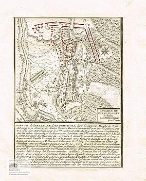
Bataille de Kunersdorff. Schlacht bei Kunersdorf 1759. Kleiner altkolorierter Kupferstich um 1780
Georg Joseph Cöntgen (1752-1799), deutscher Kupferstecher; Laurids de Therbu (Lebensdaten unbekannt), französischer Leutnant und Zeichner
Language: French
Published by ohne Orts- und Verlagsangabe um 1780
- First Edition
- Map
Seller: historicArt Antiquariat & Kunsthandlung, Wiesbaden-Breckenheim, GermanyhistoricArt Antiquariat & Kunsthandlung
Contact seller5-star sellerCondition: Used
US$ 59.40
US$ 13.84 shippingShips from Germany to U.S.A.Quantity: 1 available
Add to basket1. kleiner bis an die Umfassungslinie beschnittener unsignierter Original-Kupferstich, alt koloriert und auf Bütten der Zeit mit Wasserzeichen aufgewalzt, unterhalb der bildlichen Darstellung Erläuterungen zu den Kommandanten und Truppenaufstellungen in französischer Sprache, der sehr detaillierte Schlachtenplan ist nicht signie…rt, dürfte aber auf den Zeichnungen von Laurids de Therbu und Stichen von Georg Joseph Cöntgen basieren, bildliche Darstellung ca. 12 x 8,5 cm, Blattgröße ca. 21 x 16,5 cm, gut erhalten, sehr selten 2100 gr.
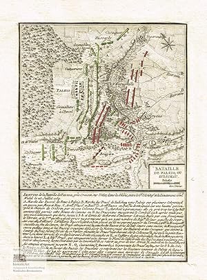
Bataille de Pälzig, ou Zulichau. Schlacht bei Palzig bei Züllichau 1759. Kleiner altkolorierter Kupferstich um 1780
Georg Joseph Cöntgen (1752-1799), deutscher Kupferstecher; Laurids de Therbu (Lebensdaten unbekannt), französischer Leutnant und Zeichner
Language: French
Published by ohne Orts- und Verlagsangabe um 1780
- First Edition
- Map
Seller: historicArt Antiquariat & Kunsthandlung, Wiesbaden-Breckenheim, GermanyhistoricArt Antiquariat & Kunsthandlung
Contact seller5-star sellerCondition: Used
US$ 59.40
US$ 13.84 shippingShips from Germany to U.S.A.Quantity: 1 available
Add to basket1. kleiner bis an die Umfassungslinie beschnittener unsignierter Original-Kupferstich, alt koloriert und auf Bütten der Zeit mit dekorativem Wasserzeichen aufgewalzt, unterhalb der bildlichen Darstellung Erläuterungen zu den Kommandanten und Truppenaufstellungen in französischer Sprache, der sehr detaillierte Schlachtenplan ist…nicht signiert, dürfte aber auf den Zeichnungen von Laurids de Therbu und Stichen von Georg Joseph Cöntgen basieren, bildliche Darstellung ca. 12 x 8,5 cm, Blattgröße ca. 21 x 16,5 cm, gut erhalten, sehr selten 2100 gr.
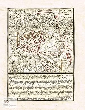
Bataille de Zorndorff. Schlacht bei Zorndorf 1758. Kleiner altkolorierter Kupferstich um 1780
Georg Joseph Cöntgen (1752-1799), deutscher Kupferstecher; Laurids de Therbu (Lebensdaten unbekannt), französischer Leutnant und Zeichner
Language: French
Published by ohne Orts- und Verlagsangabe um 1780
- First Edition
- Map
Seller: historicArt Antiquariat & Kunsthandlung, Wiesbaden-Breckenheim, GermanyhistoricArt Antiquariat & Kunsthandlung
Contact seller5-star sellerCondition: Used
US$ 59.40
US$ 13.84 shippingShips from Germany to U.S.A.Quantity: 1 available
Add to basket1. kleiner bis an die Umfassungslinie beschnittener unsignierter Original-Kupferstich, alt koloriert und auf Bütten der Zeit mit Wasserzeichen aufgewalzt, unterhalb der bildlichen Darstellung Erläuterungen zu den Kommandanten und Truppenaufstellungen in französischer Sprache, der sehr detaillierte Schlachtenplan ist nicht signie…rt, dürfte aber auf den Zeichnungen von Laurids de Therbu und Stichen von Georg Joseph Cöntgen basieren, bildliche Darstellung ca. 12 x 8,5 cm, Blattgröße ca. 21 x 16,5 cm, gut erhalten, sehr selten 2100 gr.
 More images
Published by Lieut Therbu 1789
- Hardcover
Seller: Barry Lawrence Ruderman, La Jolla, U.S.A.Barry Lawrence Ruderman
Contact seller5-star sellerCondition: Used - Very good
US$ 6,500.00
US$ 14.50 shippingShips within U.S.A.Quantity: 1 available
Add to basketHardcover. Condition: VG+. A Rare Unfinished Work on the Battles of the Seven Years War -- Including North American Battles This is a finely bound example of one of the rarest sets of battle plans of the Seven Years War, including 4 French &a. Large folio. 42 battle plans. Contemporary full calf, elaborately decorated in bl…ind. Center panel lozenge, surrounded by intricate scroll-work rectangles interspersed by triple-rules, all in blind. Additional smaller lozenge-shaped decorations within borders. Corners and edges a bit frayed. 5-inch tear to leather at lower spine. Inner front joint separating from book block. Internally very clean. Title page (i.e. "prospectus") present in two examples. A Rare Unfinished Work on the Battles of the Seven Years War -- Including North American Battles This is a finely bound example of one of the rarest sets of battle plans of the Seven Years War, including 4 French & Indian War battle plans. This collection of 42 battle plans from the Seven Years' War offers a sweeping view of the conflict s major European and global theaters, emphasizing the diversity of nations and forces involved. In Central and Eastern Europe, the Prussian campaigns led by Frederick the Great feature prominently, with key battles against Austria, France, and Russia. These include strategic engagements in Bohemia, Silesia, and Saxony, where Prussia clashed with the Austrian Habsburgs and their allies, such as in the Bataille de Prague and Bataille de Leignitz. The Russian involvement is particularly notable in battles like Zorndorf and Kunersdorf, illustrating the complex alliances that brought Prussia into conflict with both western and eastern European powers. These plans also reflect the geopolitical importance of fortified cities and strongholds, with sieges of cities like Schweidnitz and Berlin showing the war s impact on urban centers. The collection also highlights the Western European theater, where France confronted Britain and its allies, including Hanover and Hesse, in battles across Germany and the Low Countries. French forces fought in significant battles such as Hastenbeck and Minden, striving for control over territories in the Rhineland and Westphalia. Meanwhile, the global aspect of the Seven Years' War is captured through plans of engagements in North America and the Caribbean, where British and French colonial ambitions collided. A total of 5 battle plans, including Fort William Henry, Fort Carillon (later Fort Ticonderoga), Fort Oswego (later known as Fort Ontario and Fort George) and Fort Louisbourg reflect the contest for control over key regions in North America, while the siege of Guadeloupe emphasizes the war's reach into the Caribbean. Altogether, these plans underscore the war's multinational scope, involving nearly all the major European powers and extending into colonial territories across the globe. The title page is present in the form of a Prospectus for the work, which was likely issued in serial format between 1789 and 1791. The Prospectus suggests that 3 plans per month was planned for publication from April 1, 1789 to April 1, 1791, many were apparently never published. In the present example, the red underlining on the first of the two title/prospectus pages suggests that only 42 plans were produced as of the time that the present set was bound, corresponding with the number of plates present in this set. The note from the author on the Prospectus translates as follows: the author ensures that the 74 plans included in this work are derived from reliable sources and executed with the utmost precision. The plans, engraved by Mr. Contgen, an esteemed engraver of the Electoral Court and University of Mainz, will feature detailed representations of the terrain, positions, and troop movements, all clearly distinguishable. Each plan. Book.

Published by Coentgen, Georg Joseph, Mainz 1763
Seller: Antikvariat Krenek, Prag, Czech RepublicAntikvariat Krenek
Contact seller5-star sellerCondition: Used
US$ 89.11
US$ 16.72 shippingShips from Czech Republic to U.S.A.Quantity: 1 available
Add to basket"Plan de Wesel". Orig. Kupferstich nach Therbu; gest. von G. J. Cöntgen. Mainz, 1763. Befestigungsplan von Wesel mit Fr. Erklärungen unten ("Siege de Wesel"). 36:23,5 cm.

Published by Coentgen, Georg Joseph, Mainz 1763
Seller: Antikvariat Krenek, Prag, Czech RepublicAntikvariat Krenek
Contact seller5-star sellerCondition: Used
US$ 118.82
US$ 16.72 shippingShips from Czech Republic to U.S.A.Quantity: 1 available
Add to basket"Plan de Dusseldorff". Orig. Kupferstich nach Therbu; gest. von G. J. Cöntgen. Mainz, 1763. Befestigungsplan vom bombardierten Düsseldorf mit Fr. Erklärungen unten ("Plan du bombardement de Dusseldorf commence le 28. Juin 1758"). 35,5:23,5 cm.
 More images
Seller: Antiquariat Lenzen, Düsseldorf, GermanyAntiquariat Lenzen
Contact seller5-star sellerCondition: Used
US$ 142.57
US$ 74.97 shippingShips from Germany to U.S.A.Quantity: 1 available
Add to basket(Gottlieb Friedrich Abel, geb. 03.06.1763 in Stuttgart, gest. 16.05.1820 ebenda, deutscher Kupferstecher und Botaniker. Laurids de Therbu, deutscher Kartograf, Zeichner, Lieutenant Ingenieur und Verleger des 18. und 19. Jahrhunderts). Altkolorierter Kupferstich von [Gottlieb Friedrich] Abel à Stoutgart nach [Laurids de] Therbu,…Lieut. Ingenieur. Mit Meilenzeiger. Erschien 1790 in Frankfurt bei Christian Jäeger, Major Ingenieur J. F. Roesch, Stuttgart (Hrsg.). Gerahmt hinter Glas/Passepartout und transparenter Folie im vergoldeten Holzrahmen. Nicht ausgerahmt. Maße Abbildung: 20,1 x 19,9 cm. Maße Rahmen: 38,0 x 32,5 cm, rückseitig mit einem Haken zur Aufhängung. Rahmen mit leichten Gebrauchsspuren, rückseitig mit handschriftlichem Vermerk. Guter bis sehr guter Zustand. Coloured copper etching by [Gottlieb Friedrich] Abel à Stoutgart after [Laurids de] Therbu, Lieut. Ingenieur. With miles indicator. Published 1790 in Frankfurt at Christian Jäeger, Major Ingenieur J. F. Roesch, Stuttgart (Ed.). Framed behind glass/passepartout and a thin transparent foil in a gilded wooden frame. Not examined out of frame. Picture size: 20.1 x 19.9 cm. Frame dimensions: 38.0 x 32.5, with one hook for mounting at the backside. Frame with slight traces of use, backside with one handwritten note. Nearly fine condition.

Attaques du Fort William-Henri.
1792 Therbu Map of the Siege of William Henry (Lake George, NY) During the French and Indian War
- Map
Seller: Geographicus Rare Antique Maps, Brooklyn, U.S.A.Geographicus Rare Antique Maps
Contact seller4-star sellerVery good. Closed tear extending 1.25 inches through upper right margin professionally repaired on verso. Size 15 x 9.5 Inches. This is a 1792 Laurids de Therbu map of the 1757 siege of Fort William Henry during the French and Indian War (1754 - 1763). It was built by the British in September 1755 on the southern shore of Lake G…eorge as a launching point for attacks against Fort St. Frédéric, a French fort. Both forts were part of a line of strongpoints along the strategic inland waterway from Montreal to New York City. A Closer Look French trenches and artillery batteries surround the fort. They are marked alphabetically and correspond with an index below the map. Fort William Henry is situated near the center, and lines illustrate the French bombardment of the fort and the British positions on the high ground to the right of the fort. The Siege of Fort William Henry On August 3, 1757, French commander Lieutenant General Louis-Joseph de Montcalm laid siege to the fort. The besieged British garrison suffered several days of bombardment and heavy casualties, and on August 8, the British commander, Lieutenant Colonel George Monro, entered negotiations to surrender the fort. The withdrawal of the garrison was included as part of the terms of surrender. However, Montcalm's Indian allies (which numbered as many as 2,000) did not abide by the terms of surrender and massacred many captured soldiers and civilians and took as prisoners women, children, and servants. It is unclear how many were killed in the massacre; contemporary accounts of the event claimed that as many as 1,500 had been killed, but modern historians believe it was likely not much more than 200. Montcalm secured the release of 500 of the individuals captured by the Indians, but the Indians still left with over 200. The French army razed the fort. Today, a replica is a popular tourist attraction in Lake George and operates as a living museum. Publication History and Census This map was drawn by Laurids de Therbu, engraved by Georg Cöntgen, and published by Therbu in 1792 in his atlas of the Seven Years' War titled Les Plans de la Guerre de Septs Ans contenans les Batailles, Combats, Prises de Villes, Camps, etc. dessiné par L. Therbu Lieut. Ingen. gravés et mis au jour aux dépens de l'auteur même à Maïence . We note 7 examples cataloged in OCLC which are part of the collections at the University of Michigan, the University of Virginia, the Universitätsbibliothek Bern, the Landesbibliothek Coburg, the Universitäts- und Landesbibliothek Darmstadt, the Württembergische Landesbibliothek, and the Universitäts- und Landesbibliothek Sachsen-Anhalt. We note only a handful of instances when this map has appeared on the private market. Les Plans de la Guerre de Septs Ans is cataloged as part of approximately a dozen collections in the United States and Europe. References: OCLC 634838052, 1257896982.


