Order Total (1 Item Items):
Shipping Destination:

Tortechaux (1 results)
Skip to main search results
Search filters
Product Type
- All Product Types
- Books (No further results match this refinement)
- Magazines & Periodicals (No further results match this refinement)
- Comics (No further results match this refinement)
- Sheet Music (No further results match this refinement)
- Art, Prints & Posters (No further results match this refinement)
- Photographs (No further results match this refinement)
- Maps (1)
- Manuscripts & Paper Collectibles (No further results match this refinement)
Condition Learn more
- New (No further results match this refinement)
- As New, Fine or Near Fine (1)
- Very Good or Good (No further results match this refinement)
- Fair or Poor (No further results match this refinement)
- As Described (No further results match this refinement)
Binding
- All Bindings
- Hardcover (No further results match this refinement)
- Softcover (1)
Collectible Attributes
- First Edition (No further results match this refinement)
- Signed (No further results match this refinement)
- Dust Jacket (No further results match this refinement)
- Seller-Supplied Images (1)
- Not Print on Demand (1)
Language (1)
Price
- Any Price
- Under US$ 25 (No further results match this refinement)
- US$ 25 to US$ 50 (No further results match this refinement)
- Over US$ 50
Free Shipping
- Free Shipping to U.S.A. (No further results match this refinement)
Seller Location
Seller Rating
-
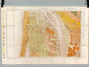
Lesparre. Carte topographique de l'Etat-Major. Carte géologique détaillée
Language: French
Published by Service de la Carte géologique de France, 1964
Map
souple. Condition: Bon. 1e édition, Carte entoilée dépliante en couleurs format 94 x 63 cm, carte numéro 170 1/80 0000, 1964, Service de la Carte géologique de France Superbe carte géologique ancienne aussi intéressante que décorative et méritant d'être encadrée. Les explorations et les tracés géologiques ont été faits en 1955 et 1956 par Pratviel, Dupuy, Fargues et Tortechaux, la feuille a été publiée en 1964, M. Jean Goguel Inspecteur Général des Mines. Bel état (mention manuscrite "Lesparre" sur l'épaisseur pour l'identifier, très bel état par ailleurs). La carte couvre notamment la partie nord de l'étang d'Hourtin. On y joint sa notice détaillée Langue: Français.