Order Total (1 Item Items):
Shipping Destination:

Tsutsuki (2 results)
Author:
tsutsuki
Refine with Advanced Search
Skip to main search results
Search filters
Product Type
- All Product Types
- Books (2)
- Magazines & Periodicals (No further results match this refinement)
- Comics (No further results match this refinement)
- Sheet Music (No further results match this refinement)
- Art, Prints & Posters (No further results match this refinement)
- Photographs (No further results match this refinement)
- Maps (No further results match this refinement)
- Manuscripts & Paper Collectibles (No further results match this refinement)
Condition Learn more
- New (No further results match this refinement)
- As New, Fine or Near Fine (No further results match this refinement)
- Very Good or Good (1)
- Fair or Poor (No further results match this refinement)
- As Described (1)
Binding
- All Bindings
- Hardcover (No further results match this refinement)
- Softcover (1)
Collectible Attributes
- First Edition (No further results match this refinement)
- Signed (No further results match this refinement)
- Dust Jacket (No further results match this refinement)
- Seller-Supplied Images (1)
- Not Print on Demand (2)
Language (1)
Free Shipping
- Free Shipping to U.S.A. (No further results match this refinement)
Seller Location
Seller Rating
-

Role of heparin binding EGF-related peptides in proliferation and apoptosis of activated ras-stimulated intestinal epithelial cells.,.
Published by Int. J. Cancer 73, 917-923 (1997).,, 1997
SC. Condition: Gut. Obr., [SDG146]. Deu 400g.
-
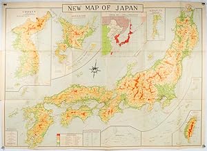
New Map of Japan.
Published by Nihon-Kenkyusha., Tokyo., 1935
Seller: Asia Bookroom ANZAAB/ILAB, Canberra, ACT, Australia
Association Member: ANZAAB ILAB
Seller rating 5 out of 5 stars

Large folding colour map of Japan 74.3 x 10⁵ cms; folding into printed card covers 27 x 19.5 cms: 9 insets: Chosen (Korea); Hokkaido; Chisima Islands; General Map of Japan and Manchuokuo; Karafuto (Saghalien); Okinawa (Loochoo); Taiwan (Formosa); Micronesia; Ogasawara; Hajijoshima; the covers a litle worn and marked, and the sheet slightly toned, but the map is in very bright, clean condition. Scarce World War II era map of Japan (including Korea), published in English by Kenkyusha. Founded in 1907, it had a history of publishing for students of English and the English market. An attractively composed map in remarkbable condition; with the insets circled around the islands of Japan, heights marked in graduations from green to red, and showing provinces, railways, roads, steamer routes, Buddhist and Shinto Temples.