Upper West Side (3 results)
 More images
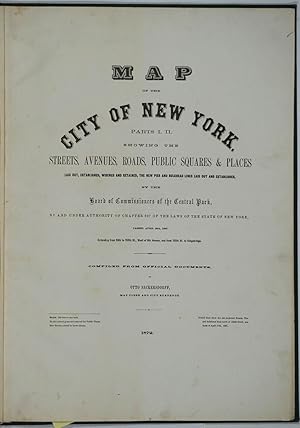
Published by New York 1872
- Hardcover
Seller: Antipodean Books, Maps & Prints, ABAA, Garrison, NY, U.S.A.Antipodean Books, Maps & Prints, ABAA
Contact seller3-star sellerHardcover. Condition: Very good + condition. Maps of Manhattan's west side, prior to the completion of Central Park, which was finished in 1876. The maps were compiled by longtime New York City Department of Public Works map clerk and city surveyor Otto Sackersdorff, noted for his 'Maps of Farms, Commonly called The Blue Book, 1…815". The Blue Book was not published until 1868, as a demonstration of northern economic might at the end of the Civil War. The real estate maps show property lines, existing roads, parks, shorelines, wetlands, and the Manhattan grid, extending from west of 8th Avenue at 59th Street and Columbus Circle up to 222nd Street and Spuyten Duyvil & Kingsbridge. Parks and major thoroughfares include: Central Park, St. Nicholas Avenue, Fort Washington Park, Kingsbridge Road, and High Bridge Park. Folio, 15 x 20 1/2", 14 maps in total: 1 full page and 13 double page (28 x 20") hand colored lithographed map sheets. Each map contiguous with one another. Period quarter green gilt leather and dark green buckram boards. Spine gently rubbed; the maps exceptionally bright and clean. Previous owner inscription, in pencil, E. B. Van Winkle from Chas. H. Myers, July 1875. Van Winkle was a civil engineer with an interest in road construction and drainage, having written a report on the drainage of the 23rd & 24th wards of New York City. Myers was an Assistant Engineer in Charge of Sewers for New York City. OCLC: 41175506 at Princeton and OCLC: 40671892 at Columbia and the New York Public Library.

Map of the Strikers Bay Farm Estate of Mrs. Ann Rogers Decd. Part of the estate of John Glendining and part of the Herman Le Roy Farm.
1867 Holmes Map of the Upper West Side and Manhattan Valley, New York City
- Map
Seller: Geographicus Rare Antique Maps, Brooklyn, NY, U.S.A.Geographicus Rare Antique Maps
Contact seller4-star sellerVery good. Relined with fresh linen. Surface abrasion and repaired splits. Size 24 x 34 Inches. One of only 5 known examples of John Bute Holmes's c. 1874 cadastral map of the northern part of the Upper West Side and Manhattan Valley, New York City. The map covers from 96th street to 107th street and from the Hudson River to Cen…tral Park (8th Avenue / Central Park West). Today, with its proximity to both Riverside Park and Central Park, this is one of Manhattan's most desirable neighborhoods. A Closer Look This map is a cadastral map, that is, a map illustrating property lines and lots. It employs color coding, overprinting, and an alpha numeric system, to identify both old property lines dating to the earliest days of Manhattan's development and modern street grid and property lines compliant with the 1811 Commissioner's Plan. Old gentlemanly estates, most overlooking the Hudson, appear in red - these belonged with wealthy families, most of Dutch and English descent, who owed much of this land, among them Strikers, Rogers, Glendining, and Le Roy. Modern day Broadway, also called Bloomingdale Road, winds its way from north to south, as does the course of the Croton Aqueduct. Proposed expansions, including property lots, extend well into the Hudson River. To the left of the map, a long list of deeds and conveyances breaks down the real estate history of the area. Holmes' 'Farm Maps' In the early 19th century most of Manhattan was undeveloped farmlands, the property of wealthy landowners with claims dating to the Dutch period of New York's history. The northern 2/3rd Manhattan was dotted with farmlands and sprawling gentlemanly estates, many with great manor houses overlooking the Hudson River. The Commissioner's Plan of 1811 and the 1807 Commission Law, laid the street grid through many of these properties and gave the city the right to claim these lands under eminent domain, providing due compensation to the landowners. While this work occurred early in lower Manhattan, central and upper Manhattan were not formally acquired by the city until the mid-19th century. Holmes became fascinated by the early history of Manhattan real estate ownership, recognizing the wealth to be accrued by accurately understanding the history of city land ownership, division, and inheritance. Moreover, Holmes allied himself with the corrupt Tweed administration, assuring himself and his allies even greater wealth and political power from the eminent domain seizure of old Manhattan estates. Holmes created a series of maps, reminiscent of John Randall's 'Farm Maps', overlaid with property data, showing the borders of old estates, and notating the breakup of the lands among various heirs. The complex work of compiling the maps earned Holmes a fortune, with one newspaper suggesting on his death in 1887 that some of his individual maps were worth more than 30,000 USD. There is no complete carto-bibliography of Holmes' maps, but we believe there to be at least 50 maps, possibly more. Publication History and Census This map was published by John Bute Holmes sometime between 1867 and 1872, probably on the earlier side. It was engraved and lithographed by the firm of Gustav Braeunlich and Co., who were located at 85 White Street during this period. There is only one edition. Holmes' cadastral maps are today all extremely rare. Of the present map, only three examples are cited in the OCLC with Stanford and the NYPL possibly holding a fourth and fifth. References: OCLC 50558352.

[Cadastral Survey of Upper West Side between 85th and 89th Streets]
1856 Cadastral Survey of Upper West Side (85th - 89th Streets), New York City
- Map
Seller: Geographicus Rare Antique Maps, Brooklyn, NY, U.S.A.Geographicus Rare Antique Maps
Contact seller4-star sellerGood. Manuscript pen and ink on vellum. Some fold wear and minor loss at centerfold. Soiling. Size 12 x 7.5 Inches. An uncommon early manuscript cadastral map and document recording land transactions on Manhattan's Upper West Side, near Central Park. The manuscript, dated 1856, features an eastward oriented manuscript map detail…ing the street and property lots between Central Park and Broadway, here identified as Bloomingdale Road, and between 85th and 89th streets. This area includes parts of modern-day Central Park West, Columbus Avenue, and Amsterdam Avenue. The map is a request to the city to search for mortgages, liens, and other conveyances associated with these lands and the deeds that hold them. The map features some of New York City's most prominent names, including Peter Augustus Jay (son of John Jay), Herman Le Roy Edgar, William Edgar, Newbold Edgar, Robert R. Morris, Hannah Morris, and Martin Zabriskie. The document is no doubt associated with property disputes related to Stillwell Lane (near modern day 85th Street) and associated lands. This was prepared for Gouverneur M. Ogden, an early trustee of Columbia University. Central park would have been in the early stages of construction when this map was drawn. Such maps are rare and provide a unique insight in to the urban development of New York neighborhoods.


