Order Total (1 Item Items):
Shipping Destination:

Valk Gerard (216 results)
Skip to main search results
Search filters
Product Type
- All Product Types
- Books (80)
- Magazines & Periodicals (No further results match this refinement)
- Comics (No further results match this refinement)
- Sheet Music (No further results match this refinement)
- Art, Prints & Posters (27)
- Photographs (No further results match this refinement)
- Maps (109)
- Manuscripts & Paper Collectibles (No further results match this refinement)
Condition Learn more
- New (No further results match this refinement)
- As New, Fine or Near Fine (14)
- Very Good or Good (96)
- Fair or Poor (4)
- As Described (102)
Binding
Collectible Attributes
- First Edition (1)
- Signed (1)
- Dust Jacket (No further results match this refinement)
- Seller-Supplied Images (205)
- Not Print on Demand (216)
Language (7)
Free Shipping
Seller Location
Seller Rating
-

Ernst Kapp. 1808-1896.
Language: Dutch
Published by Kemink en Zoon N.V.
Seller: books4less (Versandantiquariat Petra Gros GmbH & Co. KG), Welling, Germany
Seller rating 5 out of 5 stars

Broschiert. Condition: Gut. 112 Seiten; Der Erhaltungszustand des hier angebotenen Werks ist trotz seiner Bibliotheksnutzung sehr sauber. Es befindet sich neben dem R�ckenschild lediglich ein Bibliotheksstempel im Buch; ordnungsgem�� entwidmet. Einbandkanten sind leicht besto�en. In NIEDERL�NDISCHER Sprache. Sprache: Niederl�ndisch Gewicht in Gramm: 270.
-

Ernst Kapp 1808-1896. De betekenis van zijn denkbeelden voor de sociale geographie van de 20ste eeuw [proefschrift]
Published by Utrecht, Kemink en Zoon, 1939
Seller: Pallas Books Antiquarian Booksellers, Leiden, Netherlands
Seller rating 4 out of 5 stars

paperbound, 8vo 113 pp. inclusief blad met stellingen; goede conditie.
-

"Henri VII" - Henry VII (1491-1547) King of England K�nig Portrait
Language: French
Published by ca. 1700., 1700
Seller: Antiquariat Steffen V�lkel GmbH, Seubersdorf, Germany
Seller rating 5 out of 5 stars
Art / Print / Poster
Bild-Ma�e: ca. 31 x 18 cm. -- Kupferstich-Portrait. -- im Au�enrand leicht fleckig, sonst gut erhalten. || Copper engraved portrait. -- slightly stained on the outer margin, otherwise in very good condition. // Wir, das Antiquariat Steffen V�lkel, kaufen und verkaufen alte B�cher, Handschriften, Zeichnungen, Autographen, Grafiken und Fotografien. Wir sind stets am Ankauf von kompletten Bibliotheken, Sammlungen und Nachl�ssen interessiert. Sprache: Franz�sisch Gewicht in Gramm: 15.
-
Hardcover. Condition: very good. Kupferkarte, verlegt von P. Schenk, anno 1703, hinter Passepartout montiert, 14x17 und 23x26 cm.
-
Hardcover. Condition: very good. Please read german textKupferkarte, verlegt von P. Schenk in "Neuer S�chsischer Atlas", anno 1758, "LOBENSTEIN EBERSDORFF", Blattma�: 53 x 55 cm., untere Mittelfalz gebr�unt, wasserfleckig. Die Karte zeigt die reussischen Herrschafften Lobenstein und Ebersdorf (b.Coburg) mit der s�chs. Saale im Zentrum.
-

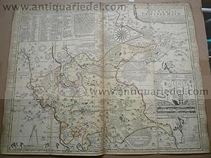
Episcopatus Dunelmensis Vulgo - The Bishoprike Of Durham - 1690-1700
Language: English
Published by Amsterdam, 1690
First Edition
US$ 276.56
US$ 33.56 shipping
Ships from United Kingdom to U.S.A.Quantity: 1 available
Add to basketNo Binding. Condition: Near Fine. 1st Edition. Date: c.1690-1700. Original copper-engraved map. Early or original hand-colouring. Sheet size: 63cm x 51.3 margins. In very near fine, bright, clean condition overall and a lovely, strong impression.
-
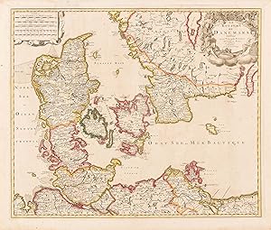
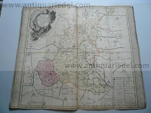
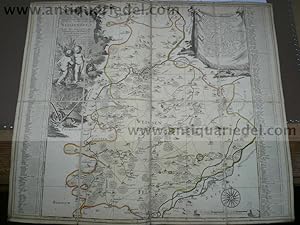
Le Royaume de Danemark Subdivise en ses Principales Provinces
Language: English
Published by Gerard Valk, Amsterdam, 1700
Map
No Binding. Condition: Very Good. Engraving 48,5 x 58 cm, old color in outline (green somewhat oxidized). A good copy of a map depicting Denmark, Sweden, and the surrounding regions. It was published by the Dutch engraver and cartographer Gerard Valk (1652-1726).
-

Hardcover. Condition: very good. Burgundiae/Franche Comte, anno 1700, Valk G Coppermap, edited by Valk Gerard, anno 1700, size of the leaf: 60x52 cm., old colours, some oxidations, small cracs.
-
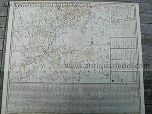
Amt Eckardtsberga, anno 1757, Schenk P., Neuer S�chsischer Atlas
Published by Schenk P.1660-1718+Valk Gerard, 1718
Hardcover. Condition: very good. Amt Eckardtsberga, anno 1757, Schenk P., Neuer S�chsischer Atlas, alt in Segmenten auf Leinwand aufgezogen, Blattma�: 51x61 cm. Mit Erfurt im S�dwesten der Karte.
-
Amt Grossenhayn, anno 1758, Schenk, Neuer s�chs. Atlas
Published by Schenk P.1660-1718+Valk Gerard, 1718
Hardcover. Condition: very good. Landkarte, verlegt von Schenk anno 1758, im Neuen s�chs. Atlas, alt in Segmenten auf Leinwand aufgezogen, Blattma�: 49x61 cm.
-

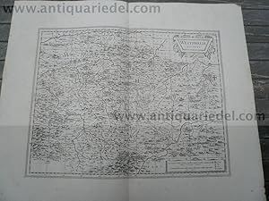
"Praefectura Piccardiae;- eaque partita in Comitatus Guinensem, Bononiensem, ac Ponticum, Capellae Praefecturum specialem, ut et Agros Vimesium, Veromanduum, Tirasciam et Sancteriensem, eorumque finitima" - Picardie Boulogne-sur-Mer Dunkerque Amiens Douai Cambrai Tournai Montreuil carte gravure
Language: French
Published by Amsterdam ca. 1700., 1700
Seller: Antiquariat Steffen V�lkel GmbH, Seubersdorf, Germany
Seller rating 5 out of 5 stars
Map
Gro�formatige altkolorierte Kupferstich-Karte von ca. 1700. -- Blatt-Ma�e: ca. 53 x 61 cm. -- gut erhalten. || Large old colored engraved map from ca. 1700. -- in good condition. // Wir, das Antiquariat Steffen V�lkel, kaufen und verkaufen alte B�cher, Handschriften, Zeichnungen, Autographen, Grafiken und Fotografien. Wir sind stets am Ankauf von kompletten Bibliotheken, Sammlungen und Nachl�ssen interessiert. Sprache: Franz�sisch Gewicht in Gramm: 550.
-
Hardcover. Condition: very good. Amt Wittenberg, Kupferkarte, verlegt von P. Schenk in Neuer S�chsischer Atlas, anno 1758. Die Karte ist in 8 Segmenten auf Leinwand aufgezogen. Blattma�: 50 x 60 cm., knapp beschnitten, gering gebr�unt. Die Lutherstadt Wittenberg befindet sich im Zentrum der Karte, Bitterfeld im S�dwesten, Belzig in Brandenburg im Norden.
-
Diss. Utrecht letteren en wijsbegeerte 8-12-1939 ; (6) + 112 + 4 p.
-
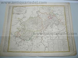
Hardcover. Condition: very good. Westphalia Ducatus, anno 1700 von Schenk/Valk Sch�ne Kupferstich Landkarte von Westphalen. Mit zwei sch�nen Kartuschen. Zeigt die Gegend zwischen Essen, Olpe, Landau und Lippe mit Meschede im Zentrum. Breitrandig, gering gebr�unt, minimal randrissig, sauber. Blattma�: 53x65 cm.
-

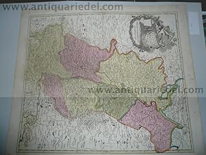
Hardcover. Condition: very good. Campaniae Praefectura,map anno 1705 Valk, old colours Coppermap, edited by Valk G. and L., anno 1705, old colours, size of the leaf: 63x52 cm., little brownish, little restorations in the fold. Detailed map of the Champagne, showing Dijon in the south and Paris in the west.
-
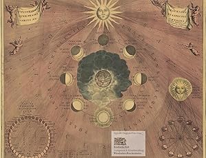
Typus Seleno Lunae Phases Varios ad Graphicus et Aspectus Umbrans. Gro�e und dekorative Himmelskarte der verschiedenen Aspekte der Mondphasen. Reprint eines kolorierten Kupferstichs von Hondius bei Schenk und Valk
Language: Latin
Published by ohne Orts- und Jahresangabe um Nachdruck aus dem "Atlas Coelestis" Amsterdam bei Gerard Valk und Petrus Schenk 1708, 1960
Seller: historicArt Antiquariat & Kunsthandlung, Wiesbaden-Breckenheim, Germany
Seller rating 5 out of 5 stars
Map
rasterloser Druck von speziell beschichteten Fotoplatten auf Maschinenb�tten, Imperialfolio-Blatt ca. 43 x 52 cm, bis an den Rand der bildlichen Darstellung beschnitten, r�ckseitig alte Montagespuren (wurde ausgerahmt), ansonsten sauber und sehr gut erhalten, auch als Faksimile-Reprint selten gro�er und/oder schwerer Artikel mit zus�tzlichen Kosten f�r Versand und Versicherung - heavy and/or oversized item with additional costs for shipping and insurance - please ask us before you order this article 2100 gr.
-
Hardcover. Condition: very good. Orleans,Course of the Loire,anno 1700,map,Valk Coppermap, edited by Valk, anno 1700, the complete course of the loire with Orleans in the center of the map. old, contemporary colours, some brown stains. Size of the map: 51 x 60 cm.
-
Hardcover. Condition: very good. Kupferkarte, verlegt bei Schenk P., in Neuer S�chsischer Atlas, anno 1758, Blattma�: 49 x 59 cm., sehr guter Erhaltungszustand.
-
Hardcover. Condition: very good. Please read german text.
-
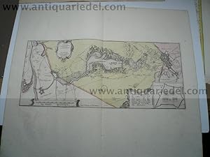
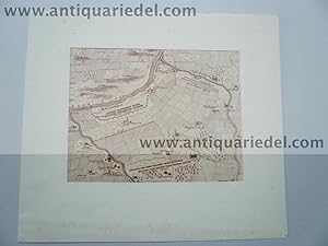
Hardcover. Condition: very good. Bergen op Zoom, anno 1700, Schenk/Valk Tabvla Bergarum ad Zomam Stenbergae. Plan mit Umgebung. Altkolor. Kupferstichkarte v. F. van Schoten bei Valk u. Schenk, Amsterdam um 1700. 22,5 x 52 cm. Mit Inset - Karte "Castra Pinsii" u. 3 Kartuschen. - Breitrandig. Gering gebr�unt.
-
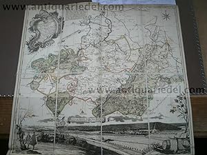
Legionis Regnum et Asturiarum Principatus
Published by c. 1690, Amsterdam, 1690
Seller: Bolivar Old Prints Anticuario, Barcelona, B, Spain
Seller rating 5 out of 5 stars
Map
Condition: Bueno. 374 x 472. Mapa antiguo original del Reino de Le�n y el Principado de Asturias, grabado por Pieter Schenk y Gerard Valk y editado en �msterdam hacia 1690. El t�tulo en lat�n, �Legionis Regnum et Asturiarum Principatus�, designa estos dos territorios hist�ricos del noroeste de la pen�nsula ib�rica. El mapa muestra enparticular las ciudades de Oviedo, Le�n, Astorga, Santillana y Palencia, representadas con sus murallas. A finales del siglo XVII, el Reino de Le�n y el Principado de Asturias formaban parte de la Corona de Castilla, y sus ciudades conservaban las fortificaciones medievales que les hab�an conferido importancia estrat�gica durante siglos. Pieter Schenk (1660-1711) y Gerard Valk (1651-1726) fueron editores y grabadores establecidos en �msterdam, donde produjeron numerosos mapas y atlas destinados al mercado europeo. Ambos colaboraron en la publicaci�n de obras cartogr�ficas que difundieron el conocimiento geogr�fico de diversas regiones de Europa. Grabado en cobre.--------------------Original antique map of the Kingdom of Le�n and the Principality of Asturias, engraved by Pieter Schenk and Gerard Valk and published in Amsterdam around 1690. The Latin title, �Legionis Regnum et Asturiarum Principatus�, refers to these two historic territories in the northwest of the Iberian Peninsula. The map shows the cities of Oviedo, Le�n, Astorga, Santillana, and Palencia, depicted with their walls. In the late seventeenth century, the Kingdom of Le�n and the Principality of Asturias were part of the Crown of Castile, and their cities retained the medieval fortifications that had given them strategic importance for centuries. Pieter Schenk (1660-1711) and Gerard Valk (1651-1726) were publishers and engravers established in Amsterdam, where they produced numerous maps and atlases for the European market. Both collaborated in publishing cartographic works that disseminated geographical knowledge of various regions of Europe. Copper engraving. Magn�ficos colores antiguos. Ejemplar refilado, sin margenes.
-
Hardcover. Condition: Gut. Please read german text.Altkolorierte Landkarte von Peter Schenk, zeigt den Rheinlauf bis Philippsburg. Im Westen das Elsass und im Osten Baden. Blattma�: 62 x 53 cm. Altkoloriert und tadellos erhalten.
-
Hardcover. Condition: very good. Kupferkarte, verlegt bei G und L Valk, anno 1700, altkoloriert, Blattma�: 50x60 cm., untere mittelfalz hinterlegt, min. gebr�unt, etwas fingerfleckig. Zeigt Norddeutschland ab Kassel.
-
Naumburg/Zeitz, Karte, anno 1750 Schenk P., altkoloriert
Published by Schenk P.1660-1718+Valk Gerard, 1718
Hardcover. Condition: very good. Altkolorierte Kupferkarte, verlegt von P. Schenk, anno 1750, alt in Segmenten auf Leinwand aufgezogen, altkoloriert, Blattma�: 52x56 cm. F�r weitere Infos zur Karte bitte unteren Link anklicken.
-
Amt Weissenfels, anno 1760, Karte altkol. P. Schenk
Published by Schenk P.1660-1718+Valk Gerard, 1718
Hardcover. Condition: very good. 'Accurate Geographische Delineation des Hochf. Sach�. Amtes Weissenfels Nebst allen darzu geh�rigen St�dten Flecken Dorffschafften wie auch etlichen angraentzenden Orten. Gestochen von Peter Schenk in Amsterdam mit Konigl. und Churfurstl. Sachs. Privilegio.': Altkol. Kupferstich Petrus Schenk in Amsterdam, 1760, alt in Segmenten auf Leinwand aufgezogen, Blattma�: 50x60 cm. Zeigt das Amt Wei�enfels mit dem Gebiet Zeitz, Dothen und Frankleben.
-
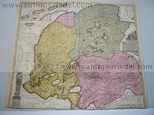
Frisiae dominium,Schenk P.,anno 1706, full coloured
Published by Schenk P.1660-1718+Valk Gerard, 1718
Hardcover. Condition: very good. Frisiae dominium,Schenk P.,anno 1706, full coloured Coppermap, contemporary full coloured, edited by P.Schenk anno 1706, below margin trimmed, size: 50 x 60 cm. Two restored cracs, not to see in the map.
-

Hardcover. Condition: very good. Toskana, anno 1700, Valk, old colours Coppermap, edited anno 1700, by L. Valk, old colours, size of the leaf: 51 x 61 cm., printed on thick paper, below centerfold restored, little brownish on right side.
-

Hardcover. Condition: very good. Coppermap, edited by Schenk/Valk, "NAMURCUM COMITATUS, anno 1700, size of the leaf: 52 x 60 cm., old colours, little brownish, wide margins.
-

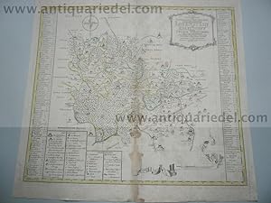
Schenk P., Portugal, anno 1703, conremporary colours
Published by Schenk P.1660-1718+Valk Gerard, 1718
Hardcover. Condition: very good. Schenk P., Portugal, anno 1703, conremporary colours Schenk, P. 'CORONA PORTUGALLIAE ET ALGARBIAE.'. Map of Portugal with cartouche and table of explanations. Pieter Schenk 1703 59 x 49 cm. The map in full original colour. Some restorations on below folds, below left margin restored tear with restored loss, outside of the map, please look to the pictures.
-

Hardcover. Condition: very good. Please read german text.