Order Total (1 Item Items):
Shipping Destination:

Wagrien (8 results)
Author:
wagrien
Refine with Advanced Search
Skip to main search results
Search filters
Product Type
- All Product Types
- Books (5)
- Magazines & Periodicals (No further results match this refinement)
- Comics (No further results match this refinement)
- Sheet Music (No further results match this refinement)
- Art, Prints & Posters (No further results match this refinement)
- Photographs (No further results match this refinement)
- Maps (3)
- Manuscripts & Paper Collectibles (No further results match this refinement)
Condition Learn more
- New (No further results match this refinement)
- As New, Fine or Near Fine (No further results match this refinement)
- Very Good or Good (No further results match this refinement)
- Fair or Poor (No further results match this refinement)
- As Described (8)
Binding
- All Bindings
- Hardcover (No further results match this refinement)
- Softcover (No further results match this refinement)
Collectible Attributes
- First Edition (No further results match this refinement)
- Signed (No further results match this refinement)
- Dust Jacket (No further results match this refinement)
- Seller-Supplied Images (8)
- Not Print on Demand (8)
Language (1)
Free Shipping
- Free Shipping to U.S.A. (No further results match this refinement)
Seller Location
Seller Rating
-

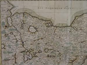
Landtcarte von dem Lande Wageren welches ist das Ostertheil von Holstein anno 1651. Faksimile einer kolor. Kupferstichkarte von M. u. N. Peters nach J. Mejer aus C. Danckwerth, Newe Landesbeschreibung der zwey Hertzogth�mer Schleswich und Holstein, Husum 1652. 42 x 51 cm.
Language: German
Publication Date: 1651
Seller: Antiquariat Daniel Schramm e.K., Kiel, Germany
Seller rating 4 out of 5 stars

Condition: 0. Mit zwei Insetkarten 'Grundtri� Oldenburg anno 1320' und 'Grundtri� Oldenburg anno 1651', zwei Rollwerkskartuschen, Meilenzeiger und Wappen.- Wagrien - Map of the country Wageren which is the eastern part of Holstein anno 1651. facsimile of a colored engraved map by M. and N. Peters after J. Mejer from C. Danckwerth. Engraved map by M. and N. Peters after J. Mejer from C. Danckwerth, Newe Landesbeschreibung der zwey Hertzogth�mer Schleswich und Holstein, Husum 1652. 42 x 51 cm. With two inset maps 'Grundtri� Oldenburg anno 1320' and 'Grundtri� Oldenburg anno 1651', two scrollwork cartouches, mileage scale and coat of arms. Sprache: Deutsch Gewicht in Gramm: 500.
-
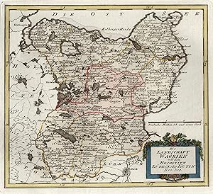
Kupferstich- Karte, b. Reilly, "Die Landschaft Wagrien mit dem Hochstift L�beck oder Eutin".
Language: German
Seller: Antiquariat Clemens Paulusch GmbH, Berlin, Germany
Seller rating 5 out of 5 stars

Map
altkol., 1791, 24,7 x 27,6 Mit ornamentaler Kartusche. Gebiet Kiel, Heiligenhafen, L�beck, Oldesloe.
-
Wagria, que est pars orientalis holsatiae. Altkolorierte Kupferstichkarte von J. Mejer bei Blaeu. Amsterdam, 1662. 43,5 x 54 cm.
Language: German
Publication Date: 1662
Seller: Antiquariat Daniel Schramm e.K., Kiel, Germany
Seller rating 4 out of 5 stars
Condition: 0. Zeigt den s�dlichen Teil Holsteins zwischen Kieler und L�becker Bucht.- Mit dekorativer fig�rlicher Titelkartusche und Meilenzeiger.- Etwas gebr�unt.- Wagria, que est pars orientalis holsatiae. Old colored copper engraving map by J. Mejer for Blaeu. Amsterdam, 1662. 43.5 x 54 cm. Showing the southern part of Holstein between the Bay of Kiel and the Bay of L�beck - With decorative figurative title cartouche and mileage scale lower left - Browned. Sprache: Deutsch Gewicht in Gramm: 500.
-

Kupferstich- Karte, v. M. u. N. Peters n. J Meyer a. Danckwerth, "Landtcarte von dem Lande Wageren. Welches ist das Ostertheil von Holstein. Anno 1651.".
Language: German
Seller: Antiquariat Clemens Paulusch GmbH, Berlin, Germany
Seller rating 5 out of 5 stars
Map
1652, 42,5 x 51,5 Mit zwei ornam. Kartuschen, am rechten Rand zwei Stadtpl�ne von Oldenburg ( im Jahr 1651 und im Jahr 1320.) - Zeigt Ostholstein. Gebiet: Kiel, Fehmarnsund, L�beck, Bad Oldesloe.
-

Kupferstich- Karte, v. A. L. Rothgiesser n. J. Meyer aus Danckwerth, "Nordertheil Uon Wageren Worinnen auch die amter Ci�mar und Oldenborg. Anno 1649".
Language: German
Seller: Antiquariat Clemens Paulusch GmbH, Berlin, Germany
Seller rating 5 out of 5 stars
Map
1652, 42 x 60,5 Dek. Karte m. mehreren ausgem. Kartuschen, in die auch Stadtpl�ne eingearbeitet sind, so von L�tjenburg, Heiligenhafen u. Neustadt. Am linken Rand 2 weitere Grundrisse von Preetz und Pl�n. Zeigt das �stl. Holstein mit Probstei, Holsteinische Seenplatte und Kreis Oldenburg. - Einige Einrisse fachgerecht restauriert.
-
Wagria, quae est pars orientalis holsatiae. Altkolor. Kupferstichkarte von J. Mejer bei Blaeu. Amsterdam, 1662. 42 x 51,5 cm.
Language: German
Publication Date: 1662
Seller: Antiquariat Daniel Schramm e.K., Kiel, Germany
Seller rating 4 out of 5 stars
Condition: 0. Zeigt den s�dlichen Teil Holsteins zwischen Kieler und L�becker Bucht. Mit Titel- und Dedikations-Kartusche sowei zwei Inset-Pl�nen.- Verso lateinischer Text.- Breitrandig. Einige kleine hinterlegte Randeinrisse.- Wagria, quae est pars orientalis holsatiae. Old col. Engraved map by J. Mejer for Blaeu. Amsterdam, 1662. 42 x 51.5 cm. Showing the southern part of Holstein between the Bay of Kiel and the Bay of L�beck. With title and dedication cartouche as well as two inset plans - Latin text on verso - Wide margins. Some small backed marginal tears. Sprache: Deutsch Gewicht in Gramm: 500.
-
Landtcarte Von dem Lande Wageren. Welches ist das Ostertheil Von Holstein. Kolorierte Kupferstichkarte von J. Mejer aus Danckwerth, 1652. 41,6 x 51 cm. In ein Passepartout montiert.
Language: German
Publication Date: 1652
Seller: Antiquariat Daniel Schramm e.K., Kiel, Germany
Seller rating 4 out of 5 stars
Condition: 0. Mit zwei Kartuschen und zwei Insetpl�nen von Oldenburg.- 1 kleiner hinterlegter Randeinriss, etwas gebr�unt.- Wagrien - Map of the land of Wageren. Which is the eastern part of Holstein. Colored copper engraving map by J. Mejer from Danckwerth, 1652. 41.6 x 51 cm. Mounted in a passepartout. With two cartouches and two inset plans of Oldenburg - 1 small backed marginal tear, somewhat browned. Sprache: Deutsch Gewicht in Gramm: 500.
-

Wagriae, Pars Septentrionalis cum praefectura Cismar et Oldenburgh. Altkolorierte Kupferstichkarte von Johannes Mejer bei Blaeu. Amsterdam, 1662. 42 x 61 cm.
Language: German
Publication Date: 1662
Seller: Antiquariat Daniel Schramm e.K., Kiel, Germany
Seller rating 4 out of 5 stars
Condition: 0. Gutes Exemplar mit pr�chtigem Altkolorit.- Zeigt die n�rdliche H�lfte der Landschaft Wagrien zwischen Bornh�ved, S�sel, Landkirchen/Fehmarn und Kieler F�rde.- Am oberen Rand Titelkartusche mit Dedikation von Johannes Mejer, flankiert von Insetpl�nen der St�dte Heiligenhafen und L�tjenburg. Am linken unteren Kartenrand zwei weitere Insetpl�ne der St�dte Preetz und Pl�n. Unten rechts Kartusche mit Insetplan von Neustadt und Erkl�rungen.- Im wei�en Au�enrand (ca. 1 cm) hinterlegt.- Wagriae, Pars Septentrionalis cum praefectura Cismar et Oldenburgh. Old colored copper engraving map by Johannes Mejer for Blaeu. Amsterdam, 1662. 42 x 61 cm. Good copy with splendid old coloring - Showing the northern half of the Wagrien landscape between Bornh�ved, S�sel, Landkirchen/Fehmarn and Kiel Fjord - Title cartouche with dedication by Johannes Mejer in the upper margin, flanked by inset plans of the towns of Heiligenhafen and L�tjenburg. Two further inset plans of the towns of Preetz and Pl�n at the lower left edge of the map. Lower right cartouche with inset map of Neustadt and explanations - backed in the white outer margin (approx. 1 cm). Sprache: Deutsch Gewicht in Gramm: 500.