
Order Total (1 Item Items):
Shipping Destination:

Weltkarten (9 results)
Skip to main search results
Search filters
Product Type
- All Product Types
- Books (9)
- Magazines & Periodicals (No further results match this refinement)
- Comics (No further results match this refinement)
- Sheet Music (No further results match this refinement)
- Art, Prints & Posters (No further results match this refinement)
- Photographs (No further results match this refinement)
- Maps (No further results match this refinement)
- Manuscripts & Paper Collectibles (No further results match this refinement)
Condition Learn more
- New (No further results match this refinement)
- As New, Fine or Near Fine (No further results match this refinement)
- Very Good or Good (No further results match this refinement)
- Fair or Poor (No further results match this refinement)
- As Described (9)
Binding
- All Bindings
- Hardcover (1)
- Softcover (No further results match this refinement)
Collectible Attributes
- First Edition (No further results match this refinement)
- Signed (No further results match this refinement)
- Dust Jacket (No further results match this refinement)
- Seller-Supplied Images (9)
- Not Print on Demand (9)
Language (2)
Price
- Any Price
- Under US$ 25 (No further results match this refinement)
- US$ 25 to US$ 50
- Over US$ 50
Free Shipping
- Free Shipping to U.S.A. (No further results match this refinement)
Seller Location
Seller Rating
-
Bucolicon Eclogae Decem. Zehn erlesene Idyllen �bersezt und erkl�rt von Johann Heinrich Voss. Zweite vermehrte Auflage herausgegeben von Abraham Voss. 2 B�nde.
Published by Altona, Hammerich, 1830., 1830
8�. Titel, 220 SS., 1 gefaltete Kupferstich-Karte; Titel, 230 SS., 1 w. Bl. Halbleder d. Zt., mit reicher R�ckenvergoldung Erweiterte zweite Ausgabe, posthum mit zus�tzlichen Kommentaren herausgegeben von dem Sohn des ber�hmten �bersetzers Abraham Voss (1785-1847). Band I mit den gedichten 1-5, Band II mit 6-10, dabei auch die sch�nen Weltkarten des Eratosthenes. - Kaum gebr�unt, etwas berieben, meist sauber, h�bsch gebunden.
-
Oestliche (und) Westliche Halbkugel.
Published by Glogau, Flemming 1850 (ca.), 1850
Seller: Buch- und Kunst-Antiquariat Flotow GmbH, Ottobrunn, Germany
Seller rating 5 out of 5 stars

, 36,5 x 44 cm Blattgr. Aus: Vollst�ndiger Hand-Atlas der neueren Erdbeschreibung . Die Darstellung der beiden Halbkugeldurchmesser je 25 cm. - Nur wei�er Rand etwas fleckig Teils get�nte Lithographie mit Original-Grenzkolorit.
-

Diversi Globi Terr-Aqvei statione variante. Faks.-Nachdruck einer Kupferstichkarte v. Silbreisen n. A.C. Seulter. Augsburg, Lotter, um 1750. 21 x 26 cm (Blattgr��e 35 x 43 cm).
Language: German
Publication Date: 1750
Seller: Antiquariat Daniel Schramm e.K., Kiel, Germany
Seller rating 4 out of 5 stars

Condition: 0. Zwei Erdkugelh�lften mit 4 Textkartuschen, 2 Sternbilddarstellungen und vier verschiedene Sonnensystem-Modellen.- World map - Diversi Globi Terr-Aqvei statione variante. Facs. reprint of a copper engraved map by Silbreisen n. A.C. Seulter. Augsburg, Lotter, about 1750. 21 x 26 cm (sheet size 35 x 43 cm). Two halves of the globe with 4 text cartouches, 2 constellations and four different models of the solar system. Sprache: Deutsch Gewicht in Gramm: 500.
-
Die Weltkarte mit dem Kolonialbesitz der gro�en M�chte. Hrsg. Zeitschriften-Buchhandlung K.O. Ga�dorf, Weimar. Duisburg, Lange, 1940. Blattgr��e: 61 x 87 cm. Gefaltet.
Language: German
Publication Date: 1940
Seller: Antiquariat Daniel Schramm e.K., Kiel, Germany
Seller rating 4 out of 5 stars
Condition: 0. Druck in Rot und Blau, verzeichnet die deutschen, italienischen, franz�sischen, englischen, belgischen und holl�ndischen Kolonien (und Mandatsgebiete).- Im Falz teils mit Einrissen.- World maps - The world map with the colonial possessions of the great powers. Published by Zeitschriften-Buchhandlung K.O. Ga�dorf, Weimar. Duisburg, Lange, 1940. sheet size: 61 x 87 cm. Folded. Printed in red and blue, listing the German, Italian, French, English, Belgian and Dutch colonies (and mandated territories) - Some tears at fold. Sprache: Deutsch Gewicht in Gramm: 500.
-

Typus Orbis Terrarum. Koloriertes Faksimile einer Kupferstichkarte von Ortelius, um 1590. 37 x 54 cm.
Language: German
Publication Date: 1590
Seller: Antiquariat Daniel Schramm e.K., Kiel, Germany
Seller rating 4 out of 5 stars
Condition: 0. Mit gro�er Titelkopfleiste, Fu�titelleiste und Wolkenstaffage.- World map - Typus Orbis Terrarum. Colored facsimile of a copper engraving map by Ortelius, around 1590. 37 x 54 cm. With large title head border, foot title border and cloud staffage. Sprache: Deutsch Gewicht in Gramm: 500.
-

Eastern Hemisphere. Grenzkolorierte Stahlstichkarte von J. Rapkin bei J. Tallis. London, 1851. 25 x 33 cm.
Language: German
Publication Date: 1851
Seller: Antiquariat Daniel Schramm e.K., Kiel, Germany
Seller rating 4 out of 5 stars
Condition: 0. �stliche Hemisphere mit Europa, Afrika, Asien und Australien. Mit dekorativer, fig�rlicher Umrahmung.- Mit Braunrand vom ehemaligem Passepartout.- World maps - Eastern Hemisphere. Border colored steel engraving map by J. Rapkin for J. Tallis. London, 1851. 25 x 33 cm. Eastern hemisphere with Europe, Africa, Asia and Australia. With decorative, figurative frame - Slightly browned. Sprache: Deutsch Gewicht in Gramm: 500.
-
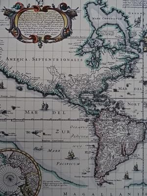
Nova Totius Terrarum Orbis Geographica ac Hydrographica Tabula. Koloriertes Faksimile einer Kupferstichkarte von Piscator, 1639. 46 x 57 cm.
Language: German
Publication Date: 1639
Seller: Antiquariat Daniel Schramm e.K., Kiel, Germany
Seller rating 4 out of 5 stars
Condition: 0. Weltkarte in Mercator-Projektion mit zwei Inset-Polkarten, sowie allegorischen Darstellungen und 8 kleinen Stadtansichten im Aussenrand.- World maps - Nova Totius Terrarum Orbis Geographica ac Hydrographica Tabula. Colored facsimile of a copper engraving map by Piscator, 1639. 46 x 57 cm. World map in Mercator projection with two inset pole maps, as well as allegorical depictions and 8 small city views in the outer margin. Sprache: Deutsch Gewicht in Gramm: 500.
-
Orbis Vetus cum origine magnarum in eo gentium a filiis et nepotibus noe. Kupferstichkarte von Ch. Rothgie�er nach J. Mejer bei Blaeu. Amsterdam, 1652. 43 x 52,5 cm.
Language: German
Publication Date: 1652
Seller: Antiquariat Daniel Schramm e.K., Kiel, Germany
Seller rating 4 out of 5 stars
Condition: 0. Weltkarte der 'Alten Welt' ohne den amerikanischen Kontinent. Europa, Asien und Afrika mit den Namen der drei S�hne Noahs bezeichnet - Sem, Cham und Iaphet. Mit ornamentalen und allegorischen Randansichten sowie vier Textkartuschen in lateinischer Sprache mit Titel, Widmung und Erl�uterungen zu Sem, Cham und Iaphet.- Knapp beschnitten in Kopf- und Fu�steg.- World maps - Orbis Vetus cum origine magnarum in eo gentium a filiis et nepotibus noe. Engraved map by Ch. Rothgie�er after J. Mejer for Blaeu. Amsterdam, 1652. 43 x 52.5 cm. World map of the 'Old World' without the American continent. Europe, Asia and Africa inscribed with the names of Noah's three sons - Shem, Cham and Iaphet. With ornamental and allegorical marginal views as well as four text cartouches in Latin with title, dedication and explanatory notes on Shem, Cham and Iaphet - Narrowly trimmed at head and foot. Sprache: Deutsch Gewicht in Gramm: 500.
-
Orbis Vetus cum origine magnarum in eo gentium a filiis et nepotibus noe. Kolorierte Kupferstichkarte von Rothgie�er nach Mejer bei Blaeu, Amsterdam, 1662. 44 x 53 cm.
Language: German
Publication Date: 1662
Seller: Antiquariat Daniel Schramm e.K., Kiel, Germany
Seller rating 4 out of 5 stars
Condition: 0. Weltkarte der 'Alten Welt' ohne den amerikanischen Kontinent. Europa, Asien und Afrika mit den Namen der drei S�hne Noahs bezeichnet - Sem, Cham und Iaphet. Mit ornamentalen und allegorischen Randansichten sowie vier Textkartuschen in lateinischer Sprache mit Titel, Widmung und Erl�uterungen zu Sem, Cham und Iaphet.- Etwas gebr�unt.- Orbis Vetus cum origine magnarum in eo gentium a filiis et nepotibus noe. Colored copper engraving map by Rothgie�er after Mejer for Blaeu, Amsterdam, 1662. 44 x 53 cm. World map of the 'Old World' without the American continent. Europe, Asia and Africa inscribed with the names of Noah's three sons - Shem, Cham and Iaphet. With ornamental and allegorical views in the margins and four text cartouches in Latin with title, dedication and explanations of Shem, Cham and Iaphet - Some browning. Sprache: Deutsch Gewicht in Gramm: 500.


