William Blaeu (15 results)
 More images
Language: English
Published by N. Israel/Publisher - Meridian Publishing Co., Amsterdam 1964
- Hardcover
- First Edition
Seller: Oxfam Bookshop Gent, Gent, , BelgiumOxfam Bookshop Gent
Contact seller5-star sellerCondition: Used - Good
US$ 59.70
US$ 31.30 shippingShips from Belgium to U.S.A.Quantity: 1 available
Hardcover. Condition: Good. No Jacket. 1st Edition. XIII - Introduction - Book 1: 114 pp - Book 2:118 pp. - With illustrations and maps. N. Israel/Publisher - Meridian Publishing Co. , Amsterdam 1964. First Edition. Hardcover. Facsimile of the Edition 1612. Theatrum Orbis Terrarum, Series of Atalases in Facsimile - First Series…- Volume VI. Grey linen covers and spine. Traces of tape. Some shelving wear. Clean and unmarked inside. Ex. lib. of the Library of the Ghent University: usual labels, stamps and numbers. Otherwise a good/very good copy.
 More images
Published by Amsterdam, 1640 ca., Amsterdam 1640
- Hardcover
Seller: libreria minerva, Padova, PD, Italylibreria minerva
Contact seller5-star sellerCondition: Used
US$ 286.55
US$ 34.78 shippingShips from Italy to U.S.A.Quantity: 1 available
Condition: Buono (Good). acquaforte inciso cm. 24 x 38,6 - foglio cm. 32,7 x 51 Buono (Good) Buon es. Book.
 More images
Published by Amsterdam,, Amsterdam 1664
- Hardcover
Seller: libreria minerva, Padova, PD, Italylibreria minerva
Contact seller5-star sellerCondition: Used
US$ 334.31
US$ 34.78 shippingShips from Italy to U.S.A.Quantity: 1 available
Condition: Buono (Good). acquaforte acquerellata a mano inciso cm. 49,8 x 41,5 Buono (Good) Buon es. Book.

Published by Amsterdam, 1640 ca., Amsterdam 1640
- Hardcover
Seller: libreria minerva, Padova, PD, Italylibreria minerva
Contact seller5-star sellerCondition: Used
US$ 358.19
US$ 34.78 shippingShips from Italy to U.S.A.Quantity: 1 available
Condition: Buono (Good). acquaforte acquerellata a mano inciso cm. 50,5 x 38,5 - foglio cm. 59,1 x 50,5 Buono (Good) buon es. Book.
 More images
Published by Amsterdam, s. e. 1640 ca., Amsterdam 1640
- Hardcover
Seller: libreria minerva, Padova, PD, Italylibreria minerva
Contact seller5-star sellerCondition: Used
US$ 358.19
US$ 34.78 shippingShips from Italy to U.S.A.Quantity: 1 available
Condition: Buono (Good). acquaforte inciso cm. 50,4 x 38,6 Buono (Good) Buon es., margini ampi. Book.

Published by Amsterdam, 1660 ca., Amsterdam 1660
- Hardcover
Seller: libreria minerva, Padova, PD, Italylibreria minerva
Contact seller5-star sellerCondition: Used - Good
US$ 394.01
US$ 34.78 shippingShips from Italy to U.S.A.Quantity: 1 available
Condition: Good. acquaforte inciso cm. 50 x 38,3 - foglio cm. 65,6 x 50,6 Buono (Good) Buon es. Book.

Published by , meta' XVII sec.
- Hardcover
Seller: libreria minerva, Padova, PD, Italylibreria minerva
Contact seller5-star sellerCondition: Used
US$ 441.77
US$ 34.78 shippingShips from Italy to U.S.A.Quantity: 1 available
Condition: Buono (Good). acquaforte acquarellata a mano inciso cm. 49,3 x 38 Buono (Good) Buon es., piccolo restauro al margine sinistro fuori dall'inciso. Book.

Published by [c. 1670, Amsterdam 1670
Seller: James Cummins Bookseller, ABAA, New York, NY, U.S.A.James Cummins Bookseller, ABAA
Contact seller5-star seller604mm x 508mm. 1 vols. 604mm x 508mm. 1 vols. Light dampstain in top margin at center, some creases near the centerfold due to poor storage, else a very good, attractive map.
 More images
Published by Amsterdam, Blaeu, [c.]. 1630
- Art Print
Seller: Inanna Rare Books Ltd., Skibbereen, CORK, IrelandInanna Rare Books Ltd.
Contact seller5-star sellerCondition: Used
US$ 447.74
US$ 32.46 shippingShips from Ireland to U.S.A.Quantity: 1 available
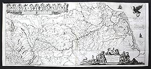
Original hand-coloured copper engraving. Plate Size: 49.7 cm x 37.7 cm. Sheet Size: 57.3 cm x 50.2 cm. Nice, bright original map in very good condition. Traces of browning and minor tearing to outer margins. French text on reverse. [Van der Krogt 2, 3380:2.2; Van der Vekene, 2.12.B; Koeman 3380:22]. Large and interesting map of…the historical Duchy of Luxembourg. Richly detailed, with relief shown pictorially. The region is dominated by the Meuse, Moselle and the River Rhine to the north. The value of the highly-contested ground is evident given the fortified towns marked on the map: Namen, Metz and Sedan: control of this region would change hands many times over the centuries as frontiers moved back and forth across maps. The map is crowded with the names of cities such as Trier, Luxemburg, Saarbrucken and Coblentz - evidence of the urban nature of the heavily populated and rich region. The vast forests such as the Ardennes are also marked on the map. Areas making up modern-day Rhineland-Palatinate (Germany), Saarland (Germany), and Lorraine (France) can be seen on the map also. In the lower left corner is the title cartouche with a coat-of-arms. In the lower right corner is the mileage bar scale. Willem Janszoon Blaeu (1571-1638) was a Dutch cartographer, atlas maker and publisher. Along with his son Johannes Blaeu, Willem is considered one of the notable figures of the Netherlandish/Dutch school of cartography in its golden age (the 16th and 17th centuries). Blaeu set up his mapmaking and publishing business in Amsterdam, where he sold instruments and globes, published maps, and edited the works of intellectuals like Descartes and Hugo Grotius. In 1633 he was appointed map-maker of the Dutch East India Company. In 1635, he released his atlas, Theatrum Orbis Terrarum, sive, Atlas novus. Willem died in 1638. He had two sons, Cornelis (1610-1648) and Johannes (1596-1673). Joan trained as a lawyer, but joined his father's business rather than practice. After his father's death, the brothers took over their father's shop and Joan took on his work as hydrographer to the Dutch East India Company. Later in life, Joan would modify and greatly expand his father's Atlas novus, eventually releasing his masterpiece, the Atlas maior, between 1662 and 1672. (Wikipedia).
Published by Amsterdam 1638
Seller: Arader Galleries of Philadelphia, PA, Philadelphia, PA, U.S.A.Arader Galleries of Philadelphia, PA
Contact seller4-star sellerCondition: Used - Very good
US$ 18,000.00
US$ 4.50 shippingShips within U.S.A.Quantity: 1 available
N/A. Condition: Very Good. Dust Jacket Condition: N/A. Engraving with original hand-color. Circa 1638. Sheet size: 17 1/2 x 22 7/8¿. Frame size: 32 x 35 1/2". Inventory#: p1913pfat. 0.
Engraved map entitled "Peru" Mar del Nort upper right from Blaeu's Atlantis Appendix, Amsterdam 1631
Published by Blaeu n.d., Amsterdam
- Signed
Seller: James Cummins Bookseller, ABAA, New York, NY, U.S.A.James Cummins Bookseller, ABAA
Contact seller5-star sellerCondition: Mounted and framed. With contemporary coloring. Large Cartouche hand-colored upper rigt "Guiana sive Amazonum Regio." Signed "Guiljelmus Blaew" lower right. 1 vols. 15-3/4 x 20 inches. With contemporary coloring. Large Cartouche hand-colored upper rigt "Guiana sive Amazonum Regio." Signed "Guiljelmus Blaew" lower righ…t. 1 vols. 15-3/4 x 20 inches. Signed.
Language: Latin
Published by ca. 1670. 1670
- Map
Seller: Antiquariat Steffen Völkel GmbH, Seubersdorf, GermanyAntiquariat Steffen Völkel GmbH
Contact seller5-star sellerCondition: Used
US$ 214.91
US$ 34.78 shippingShips from Germany to U.S.A.Quantity: 1 available
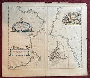
Original Kupferstich-Karte des Rheinlaufes, vom Bodensee bis zur Mündung -- von ca. 1670 - Blatt-Maße: ca. 92 x 41 cm - zwei Kupferplatten zusammengefasst -- mit einem hinterlegten Einriss; leicht gebräunt, sonst gut erhalten. -- selten || original copper engraved map of the river Rhein, from Bodensee to the North Sea -- formed…by two copper plates joined together -- dating from around 1670 - with one deposited tear, slightly brownstained, otherwise in good condition. -- rare || Dies ist ein Original! - Kein Nachdruck! - Keine Kopie! | This is an original! - No reprint! - No copy! // Wir, das Antiquariat Steffen Völkel, kaufen und verkaufen alte Bücher, Handschriften, Zeichnungen, Autographen, Grafiken und Fotografien. Wir sind stets am Ankauf von kompletten Bibliotheken, Sammlungen und Nachlässen interessiert. la Gewicht in Gramm: 35.
- Map
Seller: Graham York Rare Books ABA ILAB, Honiton, United KingdomGraham York Rare Books ABA ILAB
Contact seller5-star sellerCondition: Used - Very good
US$ 345.46
US$ 21.47 shippingShips from United Kingdom to U.S.A.Quantity: 1 available
Condition: Very good. Circa 1650, engraved map, plate size 500mm x 380mm, hand-coloured, German text on verso.

- Map
Seller: LIBRERIA ANTICUARIA MARGARITA DE DIOS, MADRID, M, SpainLIBRERIA ANTICUARIA MARGARITA DE DIOS
Contact seller5-star sellerCondition: Used - Near fine
US$ 596.98
US$ 34.78 shippingShips from Spain to U.S.A.Quantity: 1 available
Sin Encuadernar. Condition: Muy bien. Materia: Mapa antiguo de la primera mitad del siglo XVII. Cartografía. Portugal. Algarve - Willem Blaeu y Joan Blaeu. Publicación: Ámsterdam, apud Jan Janssonius, c. 1635. Dimensiones aprox.: 45 x 55 cm. Técnica: Grabado calcográfico. Reverso: Sin texto. Impreso en papel grueso y fue…rte, de gran calidad. Descripción: Mapa que representa en horizontal todo el territorio actual de Portugal, incluido el Algarve, con todos sus pueblos y localidades. Limita, por un lado, con el reino de León, Andalucía y Castilla, y, por el otro, con el Atlántico ('Oceanus Occidentalis'), donde navegan barcos y figuras marinas. Las figuras moras a ambos lados del título, destacan un periodo anterior en la historia de Portugal, cuando el Algarve y Portugal, al sur del Tajo, se hallaban bajo el dominio musulmán. Como contraste pueden verse varios barcos que señalan el poder marítimo de Portugal, marcando la trayectoria de un imperio que incluía gran parte de Sudamérica, las colonias africanas y las posesiones en Asia y las Indias Orientales (Gran Atlas de Johannes Blaeu, Editorial Libsa, pág. 136-137). Notas: Este mapa aparece también con el pie de imprenta de Willlem y Joan Blaeu. La fuente más probable es el cartógrafo portugués Fernao Alvares Seco, quien realizó el primer mapa moderno de Portugal en 1560. Esta versión de Blaeu apareció por vez primera en 1635, hacia el final de un periodo que desde 1580 había incorporado Portugal al Reino de España. Conservación: Muy buen estado. Amplios márgenes. En la familia Blaeu, destacaron Willem Janszon Blaeu (1571 - 1638) y su hijo Joan como los editores cartográficos más conocidos del siglo XVII. En primer lugar, Willem nació en Uitgeest (Países Bajos), cerca de Alkmaar, donde estudió matemáticas y aprendió la teoría y la práctica de las observaciones astronómicas y el arte de la instrumentación y el globo terráqueo. En 1596 llegó a Ámsterdam, donde se estableció como fabricante de mapas, instrumentos y globos, además de publicar su primer trabajo cartográfico y su primer mapa impreso (un mapa de los Países Bajos) en 1604. Se especializó en cartografía marítima y publicó la primera edición de la guía piloto Het Licht der Zeevaert en 1608. Después de treinta años publicando libros, mapas murales, globos terráqueos, cartas y guías para pilotos, publicó su primer atlas denominado Atlas Apéndice en 1630, de modo que comenzó la gran tradición de hacer atlas por parte de los Blaeus. Finalmente, murió en 1638, dejando su próspero negocio a sus hijos, Cornelis y Joan. Desgraciadamente, un incendio en 1672 arruinó al negocio, obligándoles a vender todas las acciones de la Casa Blaeu y a subastar sus productos, que fueron adquiridos en su mayoría por libreros que actuaban en sociedad. Este artículo necesita permiso de exportación / This item needs an export permit.
 More images
- Map
Seller: Graham York Rare Books ABA ILAB, Honiton, United KingdomGraham York Rare Books ABA ILAB
Contact seller5-star sellerCondition: Used
US$ 1,381.82
US$ 21.47 shippingShips from United Kingdom to U.S.A.Quantity: 1 available
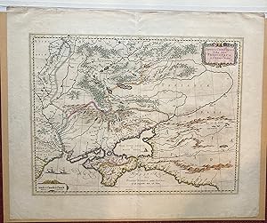
1662, size 645mm x 560mm, hand coloured, ornamental cartouche, ornamental mileage scale with cherubs, inset map of the estuary around Astrachan, inset image of merchants trading around a campfire, latin text on verso. Edges slightly frayed, otherwise very good.


