William Slight (7 results)

America's Healthcare Transformation: Strategies and Innovations
Phillips, Dr. Robert A. [Editor]; Abookire, Susan A. [Contributor]; Bates, David W. [Contributor]; Slight, Sarah [Contributor]; Chassin, Mark R. [Contributor]; DuPree, Erin S. [Contributor]; Pedroja, Alberta T. [Contributor]; Weintraub, William S. [Contributor]; Weiss, Sandra A. [Contributor]; Makam, Kasaiah [Contributor]; Garson, Arthur "Tim" [Contributor]; Gorevic, Jason [Contributor]; Hansen-Turton, Tine [Contributor]; Patric, Kenneth [Contributor]; Teske, Janet J. [Contributor]; Milstein, Arnold [Contributor]; Malcolm, Elizabeth [Contributor]; Steinhubl, Steven R. [Contributor]; Kim, Ju Young [Contributor]; Monroe, Alicia D.H. [Contributor]; Coleman, Nana Ekua [Contributor]; Andrieni, Julia D. [Contributor]; Ferrari, Mauro [Contributor]; Hoang, Hanh H. [Contributor]; Greenland, Philip [Contributor]; Karmali, Kunal N. [Contributor]; Kaplan, Gary S. [Contributor]; Ting, Henry H. [Contributor]; Boehmer, Kasey R. [Contributor]; Montori, Victor M. [Contributor]; Feeley, Thomas W. [Contr
- Hardcover
Seller: Barnes & Nooyen Books, Spring, TX, U.S.A.Barnes & Nooyen Books
Contact seller5-star sellerCondition: New
US$ 30.97
Free ShippingShips within U.S.A.Quantity: 1 available
hardcover. Condition: New. New Condition, Hardcover Book.
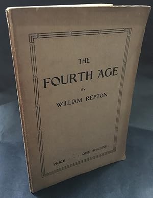
the Fourth Age
William Repton - A Slight record of the Great Civil War, 1914-1918, dedicated tot he living few who do not consult newspapers for ready-made opinions, and the noble dead who are now beyond the reach of politician's promises, editorial lies, and the patronage of the priest.
Published by the Pioneer Press, 1926
- Softcover
- First Edition
Seller: blograrebooks, Oswestry, SHROP, United Kingdomblograrebooks
Contact seller2-star sellerCondition: Used - Very good
US$ 82.68
US$ 29.57 shippingShips from United Kingdom to U.S.A.Quantity: 1 available
Add to basketSoft cover. Condition: Very Good. 1st Edition. Socialist Anti-Waranti-Religious booklet from an occasional contributor the A.R. Orage's New Age. 38 pages, think paperback. Good-Very good, covers browned, occasional foxing. Very rare.
 More images
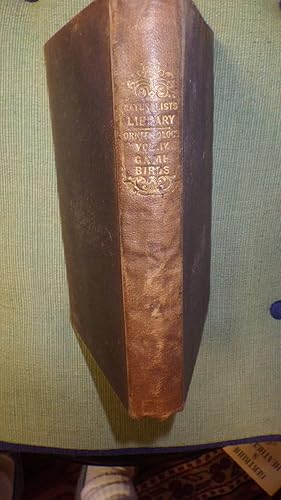
Naturalist's Library: Ornithology Vol. IV. Gallinaceous Birds Part II, Game-Birds ( Game Birds ) , inpencil someone wrote in on Title page v.6 , includes Memoir Sir Thomas Stamford Raffles, Pinnated Black Red Grouse, Common Partridge, Long-tailed Ort
Sir William Jardine, Bart. ,Illustrated by Coloured Plates, Inner Hinge slightly Starting, with Frontispiece Drawing Bust of Sir Thomas Stamford Raffles engraved for the Naturalists Library with slight foxing & Tissue Guard, Green Endpapers
Published by Edinburgh, W. H. Lizars, 1841
- Hardcover
- First Edition
Seller: Bluff Park Rare Books, LONG BEACH, CA, U.S.A.Bluff Park Rare Books
Contact seller4-star sellerAssociation member: IOBA
Condition: Used - Good
US$ 226.00
US$ 8.85 shippingShips within U.S.A.Quantity: 1 available
Add to basketHardcover. Condition: Good. No Jacket. 1st Edition. Green Endpapers Former Owner Bookplate & Pencil notes,HardBack NODustJacket, 1841, 1st Edition, 2nd Printing, 1841 dates matches on 2 Pages, VG+/GOOD+, AS-IS, NODJ, Interior Relatively Nice tight Clean Light FoX few Pencil Marks, Wear, Cover light rub, wear Fade, tiny white spo…t cover & light Stains & light Fading wrinkling Spine, Tinytears Chips Spine Area Cover, Spine decorated Lettered Gold Gilt Fade , 30 Fabulous coloured plates in Back, Numerous Hand Colored Illustrated Color Drawings Plates with Protective Guards, with List of Volumes .Includes Long-tailed Ortyx, Guazu, Tataupa ETC Very Rare Book, Dark Purple or brown cloth with Brown wrinkled spine with Rubbed decorative gold gilt, NOT HALF LEATHER, Rub wear extremities Cover.

Published by London, Eyre and Spottiswood, published at the Great Seal Patent Office c, 1869
- First Edition
Seller: M.A. Stroh., London, United KingdomM.A. Stroh.
Contact seller5-star sellerCondition: Used - Good
US$ 137.80
US$ 5.49 shippingShips from United Kingdom to U.S.A.Quantity: 1 available
Add to basketNo Binding. Condition: Good. 1st Edition. First Edition. Original Printed.
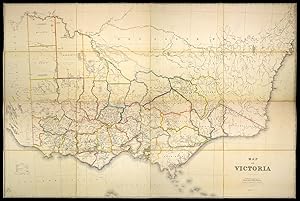
Published by Published by authority of the Government. Under the direction of A.J. Skene, MA Surveyor General, The Hon. J. J. Casey, President, Board of Land and Works & Comr. of Lands & Survey, August 15th 1872., Melbourne,, 1872
Seller: Daniel Crouch Rare Books Ltd, London, United KingdomDaniel Crouch Rare Books Ltd
Contact seller4-star sellerCondition: Used
US$ 6,890.02
US$ 26.76 shippingShips from United Kingdom to U.S.A.Quantity: 1 available
Add to basketVictoria during the Gold Rush Large lithographed map with contemporary hand-colour in outline, dissected and laid down on linen, folding into green cloth covers, gilt A detailed map of the state of Victoria. At the time of printing, Victoria was a relatively new colony, established in 1851. The discovery of gold near Ballarat an…d Bendigo a few months later set off one of the largest gold rushes in history, as settlers poured in to seek their fortunes. The map reflects the colony's source of population and wealth, showing how settlements cluster around the gold fields. The map was commissioned and overseen by Alexander Skene and the Hon. J. J. Casey. Alexander Skene was a Scottish surveyor who had a prominent role in land distribution and regulation in Australia. The Hon. J. J. Casey was the Commissioner for Victoria at the time, a colourful figure who went on to become Minister for Justice. A contemporary newspaper reports in 1878 that Casey had complained that someone without a title had preceded him into dinner at the Paris Exposition Universelle, and had told the Prince of Wales himself that Victoria should be given more land. While his manner may have been distasteful, Casey's claim was built on a solid foundation. Gold exports from Victoria enabled Britain to clear all foreign debts by the end of the century, and the explosion in population, particularly in Melbourne, meant that it was one of the most successful new colonies. However, the growth in population also initiated demands for agricultural and political reform, policies aided by the accurate surveying and mapping of Victoria, and the ultimate aim of this map. Rare: known in only a handful of examples: the Beinecke, the NLA, the State Library of NSW, and the State Library of Victoria NLA MAP RM 1945; Tooley 898.
- Hardcover
- Print on Demand
Seller: True World of Books, Delhi, IndiaTrue World of Books
Contact seller5-star sellerLeatherBound. Condition: New. BOOKS ARE EXEMPT FROM IMPORT DUTIES AND TARIFFS; NO EXTRA CHARGES APPLY. LeatherBound edition. Condition: New. Reprinted from 1974 edition. Leather Binding on Spine and Corners with Golden leaf printing on spine. Bound in genuine leather with Satin ribbon page markers and Spine with raised gilt band…s. A perfect gift for your loved ones. Pages: 566 NO changes have been made to the original text. This is NOT a retyped or an ocr'd reprint. Illustrations, Index, if any, are included in black and white. Each page is checked manually before printing. As this print on demand book is reprinted from a very old book, there could be some missing or flawed pages, but we always try to make the book as complete as possible. Fold-outs, if any, are not part of the book. If the original book was published in multiple volumes then this reprint is of only one volume, not the whole set. Sewing binding for longer life, where the book block is actually sewn (smythe sewn/section sewn) with thread before binding which results in a more durable type of binding. Pages: 566.
- Map
Seller: Daniel Crouch Rare Books Ltd, London, United KingdomDaniel Crouch Rare Books Ltd
Contact seller4-star sellerCondition: Used
US$ 6,890.02
US$ 26.76 shippingShips from United Kingdom to U.S.A.Quantity: 1 available
Add to basket"one of the most beautiful geological maps ever produced in Australia" (La Trobe) Revised. Six sheet colour printed lithograph map, joined and mounted on canvas. The third geological map of Australia after J. Beete Jukes (a modified Arrowsmith map dated 1850) and Robert Smyth (1873). It is based on Skene and Slight's earlier map… 'Continental Australia' (first published October 1879), with a second edition in 1880, followed by various editions, in whole or in part, including being used as the basis for the maps of each colony in the 'Sands Atlas' (1887). Brown reports that "at an 1880-81 exhibition in Melbourne, 'A Geological Sketch Map' of the continent, being the Skene map, hand coloured by Arthur Everett, Chief Draftsman of the Victorian Mining Department, was exhibited. The Department then went ahead with a printed version, as here, issued in November 188, on 6 sheets, printed in 11 colours at a price of £3/10/-. The 'Argus' (26 Nov 1887) commented that "as a specimen of lithographic printing, the map is a creditable work of art, the registry or joining of the various colours being free from overlaps and uncoloured areas". The 'La Trobe Journal' article of 2001 says that four editions of the maps were published in 1887-88, and refers to it as "one of the most beautiful geological maps ever produced in Australia". It comments that most of the known copies are varnished roll maps in poor condition, and that no copy seems to have been kept in the separate sheets as issued". Literature: Clancy, 'Maps that Shaped Australia', pages 17-23.


