Wwi Map (5 results)
Published by ????. [K?chi Shinbun]. Taisho 3 [1914], Japan 1914
Seller: Asia Bookroom ANZAAB/ILAB, Canberra, ACT, AustraliaAsia Bookroom ANZAAB/ILAB
Contact seller5-star sellerCondition: Used
US$ 236.53
US$ 21.25 shippingShips from Australia to U.S.A.Quantity: 1 available
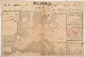
Folding map with five accompanying inset maps, all but two which are printed in black and white, printed in black and red, 79 x 53.5cm. Occasional small closed tears at margins, four small pin holes at margins. Paper evenly browned. This map, published in October 1914 shortly after the outbreak of World War I, focusses primarily… on Europe, highlighting the ongoing military activities in the region. Additionally, the map includes five inset maps that cover various topics related to Germany's presence in the Pacific, including German territories in the Pacific and China, as well as German military defense in Qingdao. The inclusion of these inset map reflects the Japanese general public's interest in Germany's activities in Asia and the Pacific during the early stages of World War I. The map was issued as a supplement to the Kochi Shinbun, a regional newspaper, suggesting that there was a demand for information on international affairs even in local publications.
 More images
ADSEC in Action from Thames to Rhine. "Feed the Flame" Brig. Gen. Edward G. Plank commanding, pictorial map and text
[Map; W.W.I.I.; US Army; Cliff Helstrom & John Ciofalo, cartographers]
Published by Np [United States?] 1945
Seller: Antipodean Books, Maps & Prints, ABAA, Garrison, NY, U.S.A.Antipodean Books, Maps & Prints, ABAA
Contact seller4-star sellerCondition: Very good overall. ADSEC was the Advance Section, Communications Zone, European Theater of Operations in W.W.I.I. This large broadside seems to be designed as a summary for soldiers who served, the text on one side detailing the planning and a pictorial map showing a trail from London to Bristol, Catz, Le Mans, Etampe…s, Paris, Rheims, Namur, Liege, Bonn from 4 March 1944 to 17 April 1945 with illustrated representations of each location. The text describes the Planning period, Invasion, Breakthrough, Battle of the Bulge, Conquest of Germany, and Finale. W.W.II Allied route maps were created by both American and British forces during and after the war. This map combines the facts of battles and dates with an artistic content is historically informative. ADSEC was charged with: furnishing logistical support to US Army under Gen. Bradley, Determine communications Zone troop requirements; Prepare over all phased supply requirements; Make detailed plans for development of ports, lines of communications, supply and service installations; Prepare plans for evacuations, salvage and repair in rear of First Army; Defend area assigned to ADSEC by First Army; Represent Commanding General, communication zone until HQ 'Com Z' arrived from England. OCLC: 45154031 supplying the date, and stating "May have been published under the auspices of the Advance Section, Communications Zone as a souvenir for its soldiers to take or send home after demobilization? Designed to be folded for mailing with a blank address block." 2 copies at the US Army War College and Texas A&M. Held at the David Rumsey Map Collection at Stanford University, G5701.S7 1945 .A3 and dated 1945. Art work by ADSEC Engrs. Sec., PFC. Cliff Helstrom, Sgt. John Ciofalo./ "Brig. Gen. Ewart G. Plank, Commanding"--Map. 28 3/4 x 21 3/8", original folds, one panel for addressing and mailing, some closed tears at fold, slt chipped at edge.
 More images
Published by Stanford's Geographical Establishment, London 1917
- First Edition
Seller: Antipodean Books, Maps & Prints, ABAA, Garrison, NY, U.S.A.Antipodean Books, Maps & Prints, ABAA
Contact seller4-star sellerCondition: Used - Fine
US$ 1,925.00
US$ 10.00 shippingShips within U.S.A.Quantity: 1 available
Map. Condition: Fine condition. First printing. A large format map illustrating the geopolitics of Europe after W.W.I. Intended to persuade viewers about the threat presented by the Central Powers of Germany, Austro-Hungary, Bulgaria and Turkey, it color-codes them in black to emphasize the danger they might pose to the fledglin…g League of Nations. The solution is stated on the map, which quotes from the Allies' war aims as articulated to President Wilson in 1916: "The civilized world knows that the aims of the Allies include-the reorganization of Europe, guaranteed by a stable settlement, based alike upon the principle of nationalities and on the right which all peoples, whether small or great, have to the enjoyment of full security and free economic development." The efforts to secure the peace in Europe dictated the division of nations, cultures and tribes has continued to plague the world for over 100 years (sellers' opinion). These groups include Greek pockets within Turkey, Armenians (in three pockets), and Kurds Arabs which includes Jewish Colonies in Palestine. Also of note and marked on the map are the "Expropriations of the German Ansiedelungs Commission," an 1886 German proclamation that allowed Prussian settlers to appropriate Polish sovereign land. Printed at The Dangerfield Printing Co. Ltd. OCLC 9876563; Persuasive Maps: PJ Mode Collection, #1188. Color lithograph, 28" x 36 1/2". Backed on acid free linen, supporting some tiny closed splits along the central & one other fold, with one triangle of added margin not affecting the map. Very bright color and overall in very good condition.

1917 Nouvelle Carte de France & A Soldier's Things
Nouvelle Carte de France & A Soldier's Things WWI Map and Memorabilia
- Map
Seller: New World Cartographic, Chicago, IL, U.S.A.New World Cartographic
Contact seller4-star sellerNouvelle Carte de France Belgique, Bords du Rhin, SuisseA Soldier's Things Mr. Elmer A. Wright, Company A 12th EngineersMap By: A. Taride Date: 1917 (circa) Paris Dimensions: 24 x 35.5 inches (61 x 90 cm)This is a unique collection of a WWI era map of France with annotations and a collection of memorabilia once belonging to Mr.…Elmer A. Wright of the Company A, 12th Engineers.According to the memorabilia, map, and a personal letter, we can deduce that Mr. Wright was an engineer who spent time in service to the United States Military in Northern France with stops in Paris and Versailles in 1918. The map of France includes annotations by Mr. Wright, a ship route from Southampton, England to Boulogne traced in pencil, and several roads extending from that region outlined in pen. At some point, Elmer Wright spent time in an American Red Cross hospital in New York City, where his service in WWI likely came to an end.The collection of memorabilia includes the following items.Business card for an industrial manufacturer of war suppliesBusiness card for a restaurant located at the former Leconte house in ParisPostcard of the Grand Trianon in VersaillesAmerican Red Cross U.S. Debarkation Hospital No. 3 in New York City. A payout in the amount of $10 due to Mr. Elmer Wright.Typed personal letter to Elmer A. Wright from H.W. Clark of the Missouri Pacific Railroad Company in Atchison, Kansas, dated February 25, 1918.Unused Soldiers Record meant to chronicle time at war with pages for personal information, locations travelled, pictures, diary, promotions, and the final page titled "Homeward Bound."Short Vocabulary of French Words and Phrases with English Pronunciation, 1917 edition. This particular piece includes three examples of pressed floral preservation that include a four-leaf clover and a lavender poppy flower.Condition: The map is in A condition folded as issued with manuscript annotations by Mr. Elmer A. Wright in the top and left margin. The condition of all other items varies, but all may be handled with care.Inventory # 121381200 W. 35th Street #425 Chicago, IL 60609 | P: (312) 496 - 3622.

Over There' and Back with the 301st First Field Artillery.
1933 Rothe and Gibbs Pictorial Map of Europe / WWI Route of 301st Artillery
- Map
Seller: Geographicus Rare Antique Maps, Brooklyn, NY, U.S.A.Geographicus Rare Antique Maps
Contact seller4-star sellerVery good. Exhibits some toning. Closed very minor margin tear professionally repaired on verso. Blank on verso. Accompanied by original typed letter from Warren Gibbs. Size 13.5 x 19 Inches. This is an extremely rare 1933 Lewis Rothe and Warren Gibbs pictorial map of Europe playfully commemorating the peregrinations of the 301s…t Field Artillery during World War I. The map traces the movements of the 301st from Boston through Nova Scotia and England to France and then back across the Atlantic to New York City after the end of the war. Created in conjunction by Lewis Rothe, the artist, and Warren R. Gibbs, a veteran of the 301st, commentary, hilarious vignettes, and in some cases a surprising level of detail, are present throughout. A series of 'close-ups' are included in the lower left, which are caricatures of some of the men in the unit that highlight, among others, Lieutenant Dowd's luck at gambling, and Colonel Brooke's habit of buying souvenirs. The Travels of the 301st The journey begins at Camp Devens in Massachusetts, with the 301st leaving the United States in July 1918 and heading to Nova Scotia before crossing the Atlantic to England, and finally the English Channel to France, all while following at dotted line with arrows pointing the way. The three of ships upon which they traveled are illustrated and named, with two of the crossings highlighted by seasick men. It appears that before the unit left England they played a game of baseball. Once in France, arriving on August 15 at Le Havre, the unit winds its way around France on foot and by train. Artillery pieces, trains, doughboys in uniform, waiters at French restaurants, and the Eiffel Tower are among the illustrations, with no sign of combat. A doughboy carries a bearded Santa Claus on his shoulder to mark Christmas 1918, two days before the unit leaves Europe to return to the United States. Publication History and Census This map was drawn by Lewis Rothe and published by Warren Rockwood Gibbs in 1933 to celebrate the fifteenth anniversary of the end of the war. We are aware of only two other examples, which are part of the institutional collections at the Wisconsin Veterans Museum Research Center and the Waltham Public Library in Waltham, Massachusetts. References: OCLC 773039257.


