Order Total (1 Item Items):
Shipping Destination:

Wytfliet (66 results)
Author:
wytfliet
Refine with Advanced Search
Skip to main search results
Search filters
Product Type
- All Product Types
- Books (62)
- Magazines & Periodicals (No further results match this refinement)
- Comics (No further results match this refinement)
- Sheet Music (No further results match this refinement)
- Art, Prints & Posters (No further results match this refinement)
- Photographs (No further results match this refinement)
- Maps (4)
- Manuscripts & Paper Collectibles (No further results match this refinement)
Condition Learn more
Binding
Collectible Attributes
Language (4)
Free Shipping
Seller Location
Seller Rating
-

PAP. Condition: New. New Book. Shipped from UK. Established seller since 2000.
-
Descriptionis Ptolemaic Augmentum, Sive Occidentis Notitia Brevi Commentario Illustrata, Et Hac Secunda Editione Magna Sui Parte Aucta Classic Reprint
Seller: PBShop.store UK, Fairford, GLOS, United Kingdom
Seller rating 5 out of 5 stars

US$ 30.66
US$ 5.55 shipping
Ships from United Kingdom to U.S.A.Quantity: 15 available
Add to basketPAP. Condition: New. New Book. Shipped from UK. Established seller since 2000.
-

Das Gold des Kondors. Berichte aus der Neuen Welt 1590 und Atlas zur Geschichte ihrer Entdeckung : Mit 19 Abb. und 20 Karten.
Published by Stuttgart. Ed. Erdmann in K. Thienemanns Verlag ., 1991
ISBN 10: 3522607503 ISBN 13: 9783522607506
Seller: Antiquariat & Verlag Jenior, Kassel, HE, Germany
Seller rating 5 out of 5 stars
380 S. Leinen mit Schutzumschlag. Sauberes Exemplar ohne Stempel und Anstreichungen. Mit einigen Abbildungen. Buchr�cken leicht lichtrandig und etwas fleckig. Gut erhalten. Sprache: deu.
-

HRD. Condition: New. New Book. Shipped from UK. Established seller since 2000.
-
Descriptionis Ptolemaic Augmentum, Sive Occidentis Notitia Brevi Commentario Illustrata, Et Hac Secunda Editione Magna Sui Parte Aucta Classic Reprint
Seller: PBShop.store UK, Fairford, GLOS, United Kingdom
Seller rating 5 out of 5 stars
US$ 40.30
US$ 6.70 shipping
Ships from United Kingdom to U.S.A.Quantity: 15 available
Add to basketHRD. Condition: New. New Book. Shipped from UK. Established seller since 2000.
-

US$ 20.00
Free Shipping
Ships from United Kingdom to U.S.A.Quantity: Over 20 available
Add to basketPaperback. Condition: New. Print on Demand. This book is a reproduction of an important historical work, digitally reconstructed using state-of-the-art technology to preserve the original format. In rare cases, an imperfection in the original, such as a blemish or missing page, may be replicated in the book. print-on-demand item.
-
US$ 20.20
Free Shipping
Ships from United Kingdom to U.S.A.Quantity: Over 20 available
Add to basketPaperback. Condition: New. Print on Demand. This book meticulously recounts the chronicles of the explorations and discoveries made by Christopher Columbus and his crew during their groundbreaking voyages to the Americas. The book paints a vivid picture of the time, capturing the spirit of adventure and discovery that fueled these expeditions. It explores the political, social, and cultural contexts of the era and provides substantial insights into the lasting impact of these voyages on the development of humanity's understanding of the world. The author delves into the themes of exploration, colonialism, and cross-cultural encounters, offering a nuanced perspective on the complexities and consequences of these early interactions between Europeans and the indigenous peoples of the Americas. This book is a reproduction of an important historical work, digitally reconstructed using state-of-the-art technology to preserve the original format. In rare cases, an imperfection in the original, such as a blemish or missing page, may be replicated in the book. print-on-demand item.
-
Descriptionis Ptolemaicae Augmentum Sive Occidentis Notitia Brevis Commentario Louvain 1597
Published by N. Israel-Meridian
Seller: Wonder Book, Frederick, MD, U.S.A.
Seller rating 5 out of 5 stars
Condition: Fair. Amsterdam: N. Israel/Meridian, 1964. Facsimile. 4to. xii,104pp. Latin. Maps. Book Good. No dust jacket. Minor edgewear. (cartography, atlases, America) Inquire if you need further information.
-
DESCRIPTIONIS PTOLEMAICAE AUGMENTUM SIVE OCCIDENTIS NOTITIA BREVIS COMMENTARIO - Louvain 1597
Language: Latin
Published by N. Israel - Meridian Pub. Co, Amsterdam, 1964
Hardcover. Condition: Very Good. Dust Jacket Condition: Good. Exact facsimile of 1597 original.1st atlas just on America. Introduction of 12 pages by the great scholar, R A Skelton (some neat ruler underlining). Dust jacket present with 3" tear repaired.104pp.
-

Descriptionis Ptolemaicae Augmentum sive Occidentis notitia brevis commentario, Louvain 1597. With an Introduction by R.A Skelton (Theatrum Orbis Terrarum, First Series Volume V)
Published by Amsterdam, N. Israel/Meridian 1964, 1964
Seller: Antiquariaat Schot, Hendrik-Ido-Ambacht, Netherlands
Seller rating 5 out of 5 stars
(XII) (frontispiece, 4) 104 p. + 19 maps, Bound in red cloth (In very good condition. Facsimile of the edition published by Johannes Bogaert at Louvain in 1597.).
-
![Seller image for La suite de l'Histoire des Indes orientales, de la conversion des Indiens 1611 [LeatherBound] for sale by S N Books World](https://pictures.abebooks.com/inventory/md/md30638612721.jpg)
La suite de l'Histoire des Indes orientales, de la conversion des Indiens 1611 [LeatherBound]
Language: French
Publication Date: 2025
Leatherbound. Condition: NEW. BOOKS ARE EXEMPT FROM IMPORT DUTIES AND TARIFFS; NO EXTRA CHARGES APPLY. Leatherbound edition. Condition: New. Leather Binding on Spine and Corners with Golden leaf printing on spine. Bound in genuine leather with Satin ribbon page markers and Spine with raised gilt bands. Pages: 67. A perfect gift for your loved ones. Reprinted from 1611 edition. NO changes have been made to the original text. This is NOT a retyped or an ocr'd reprint. Illustrations, Index, if any, are included in black and white. Each page is checked manually before printing. As this print on demand book is reprinted from a very old book, there could be some missing or flawed pages, but we always try to make the book as complete as possible. Fold-outs, if any, are not part of the book. If the original book was published in multiple volumes then this reprint is of only one volume, not the whole set. IF YOU WISH TO ORDER PARTICULAR VOLUME OR ALL THE VOLUMES YOU CAN CONTACT US. Resized as per current standards. Sewing binding for longer life, where the book block is actually sewn (smythe sewn/section sewn) with thread before binding which results in a more durable type of binding. Language: French Pages: 67.
-

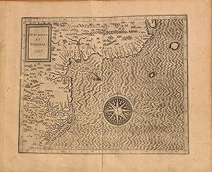
Norumbega et Virginia
Published by Louvain, 1597, 1597
Seller: James Arsenault & Company, ABAA, Arrowsic, ME, U.S.A.
Association Member: ABAA ESA ILAB
Seller rating 5 out of 5 stars
Map First Edition
Engraving, 9" x 11.5" plus margins. CONDITION: Very good, no losses. The first state of this early map depicting eastern North America, from the first atlas devoted exclusively to the New World. Notable as just the second map to use the name 'Virginia' in its title, following the White-deBry map (1590), van Wytfliet's map is an important document of European knowledge of the region prior to the discovery of geographic features like the Hudson River, Long Island or Cape Codthe northern regions collectively known as 'Norumbega.' This fine map was published in 1597 in the first edition of Cornelis van Wytfliet's landmark atlas of the Americas, Descriptionis Ptolemaicae Augmentum. In later states, the year is removed from the title. It shows the coastline of eastern North America from the Outer Banks to Cape Breton. Published in the Spanish Netherlands and dedicated to King Philip III, the map is titled in Latin and labeled in Spanish, with Indigenous names for settlements. It includes a prominent compass rose and detailed hatching in the ocean. A large sailing ship with rowers is shown off the coast. An error appears in the border on the left: the 39th parallel is mislabeled as the 30th. This error persisted into later states of the map before eventually being corrected. Additionally, the latitude is misaligned, with the entire region being pushed north about five degrees of its actual location. Based on accounts from sixteenth-century French, English and Spanish expeditions to the Atlantic coast of North America, van Wytfliet's map was produced before the early seventeenth-century explorations of New England and the mid-Atlantic by the English and Dutch. In spite of these omissions, the map is considered the most accurate to depict the region prior to Joannes de Laet's Nova Anglia, Novum Belgium Et Virginia of 1630. The southernVirginiaportion of the map is informed by recent discoveries, including Verrazzano (1524) and Raleigh (1585). Virginia here refers to a large territory along the Atlantic coast south of Chesapeake Bay, including the Carolinas. The Outer Banks are documented in detail, with recognizable names like Hatorask (Cape Hatteras), and the islands of Roanoac (Roanoke) and Croatoan. A tiny boat carrying two figures that appears in the waters between the two islands presumably alludes to either the lost English colony of Roanoke (founded 1585) or to Native American presence in the sound. Numerous palisaded Native villages are found along Pamlico and Albemarle sounds in present-day North Carolina. "Chesipooc Sinus" is recognizable as Chesapeake Bay, though its extent is not fully documented. North of Chesapeake Bay, the Norumbega portion of the map is highly speculative. A toponym of disputed origin, Norumbega was originally the name for a mythical fortified Native trading center that was broadly applied in the sixteenth century to the area later known as New England. Early travel accounts of the region described Norumbega as a territory of immense wealth with an opulent capital of the same name. While no such city was ever discovered, van Wytfliet included a large castle labeled 'Norombega,' shown at a confluence at the head of an inlet, which may be Penobscot Bay. Cornelis van Wytfliet (d. 1597) was a Flemish cartographer and Secretary of the General Council of Brabant, then a province in the Spanish Netherlands. Van Wytfliet published the first edition of his atlas Descriptionis Ptolemaicae Augmentum in Louvain in 1597, devoted to the "fourth part of the world," as a post-Columbus supplement to Ptolemy's Geography. The atlas contains nineteen regional maps of the New World, distinguishing it as the first separately-published atlas solely devoted to the Americas. Augmentum also provides a history of early voyages to the continents, including those of Columbus, John Cabot, Sebastian Cabot, Pizarro, Verrazano, Cartier, and Frobisher. REFERENCES: Burden 103; Cumming 19;Danforth 36; Koeman III: 219; Phillips 1140; Wo.
-
Descriptionis Ptolemaic� Augmentum, sive Occidentis Notitia Brevi commentario illustrata STudio et opera Cornely Wytfliet Lovaniensis
Published by Jean Bogard, Leuven, 1597
First Edition Signed
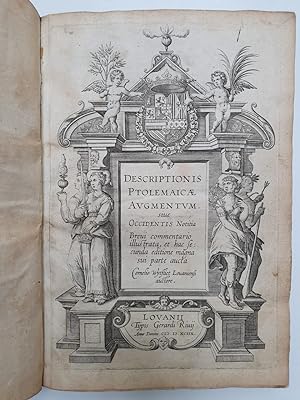
Hardcover. Condition: Near fine. First. THE FIRST ATLAS OF THE AMERICAS. First edition, first issue (Skelton/Koeman A). Louvain: Jean Bogard, 1597. Pot folio (11 3/4" x 7 5/8", 298mm x 193mm). [Full collation available.] With an engraved title-page (=[pi]1) and 19 double-page engraved maps. Bound in XXc deep brown morocco by Henri Alix (signed at the lower front turn-in). On the spine, 5 raised bands. Author and title ("CORNELY/ WYTFLIET/ [rule]/ DESCRIPTIONIS/ PTOLEMAIC�/ AVGMENTVM") gilt to the second panel, imprint gilt to the tail. Gilt fillet to the turn-ins. Marbled end-papers. All edges of the text-block gilt. Presented in a clam-shell box with an inset panel. Bowed, with some light rubbing at the extremities. A repaired tear to the upper edge of the [pi]1 blank, small paper-faults to the lower fore-corner of B2 and the upper fore-corner of X2. Probably washed in the mid-XXc, but nicely repatinated. Small ink collation in an old hand to the verso of the fourth initial binder's blank (i.e., on old paper): "19 kaarten." Graphite corrections to the mispaginations and a notation of the final "fol blanc." Rich impressions of the plates, with plate tone (especially to the world map) and burrs. Cornelis van Wytfliet (latinized to Cornelius � Wytfliet, ca. 1550-ca. 1597) was born in Leuven (Louvain) in the Flemish Netherlands. He rose to become secretary of the Council of Brabant, the supreme court of the Duchy of Brabant under Philip IV (i.e., Philip II of Spain and Portugal). Although he almost certainly never left the Netherlands, Wytfliet -- doubtless due to his role as secretary -- gained access to the Spanish and Portuguese maps and accounts of voyages in the New World. Thus provided, he published the first atlas devoted to the Americas as an "augmentum" (enlargement) of the Ptolemaic model of the world. The "Geographical Guidance" of Claudius Ptolemaeus (Ptolemy, AD IIc) came to define geography in the XVc. When the discoveries of Columbus -- who thought he had found the East Indies because of Ptolemy's calculations and assertions about longitude -- and other navigators came back to Europe, they were simply added to the Ptolemaic conception of the world until the model collapsed under the weight of novelty. Thus Wytfliet's work is subtitled "Occidentis notitia" or "conception of the West," stitching together the accounts of the Iberian explorers as a connective tissue among the world map (Shirley 207) and 18 detail maps: eight of North America (Burden 100-107) and ten of South America. The focus on America corresponds to an unusually high quality of the maps, easily unsurpassed until those of de Laet's 1625 Nieuwe Wereldt. The first state of the book -- easily distinguished by its 95 pages of text to the second's 192 (Wyt 1 B, with narrower text and some additions) -- is quite rare. The present volume is one of two complete examples ever to have come up at auction (Sotheby's New York 24 January 2019, lot 2040). OCLC records 14 examples of the first issue in institutional collections -- with remarkable omissions such as JCB and Harvard -- of which 2 are certainly incomplete. Gallup also thanks Thomas Winthrop Streeter for access to his example, which doubtless was lot 29 in his epochal Parke-Bernet auctions 1966-1969. Henri Alix (1921-1959) began working as a binder for the Biblioth�que nationale de France in 1944 before setting out on his own in the sixth arrondisement in 1947; he was named "meilleur ouvrier de France" in 1949, an acknowledgement of exceptional achievement in craft. The bindery was absorbed into Loutrel-Delaporte in 2015. Alden & Landis 597/70; Koeman Wyt 1 A; Sabin 105696 (note refers to the Huntington first edn.). Gallup, Donald. "The First Separately Published Entirely Devoted to the Americas: Wytfliet's Descriptionis Ptolemaicae Augmentum." PBSA 76:1 (1982), 63-73: Aa.
-
Descriptionis Ptolemaicae augmentum, sive, Occidentis Notitia Brevi commentario illustrata, et hac secunda editione magna sui parte aucta Cornelio Wytfliet Louaniensi
Published by Wytfliet, 1598
Seller: Barry Lawrence Ruderman, La Jolla, CA, U.S.A.
Seller rating 5 out of 5 stars
Hardcover. Condition: VG. Wytfliet / 1598 / Descriptionis Ptolemaicae augmentum, sive, Occidentis Notitia Brevi commentario illustrata, et hac secunda editione magna sui parte aucta Cornelio Wytfliet Louaniensi (Safe 1, 117852) Folio. Half antique mottled calf, spine gilt-extra, leather label, raised bands. Sides covered in tasteful laid paper. Endpapers renewed. Maps expertly re-tabbed. [8],191,[1, list of maps] pages. Engraved allegorical title page plus 19 double-sheet engraved maps. A very clean example, the maps are especially nice. The First Atlas Devoted Entirely to the Americas: With the First Printed Map Devoted to California and the Most Accurate Map of the East Coast to Date, and the First Map to use "Canada" in its Title (Burden). Handsome example of the 1598 Louvain printing of the first atlas devoted entirely to the Americas, compiled by Cornelius Wytfliet. This version was printed by Gerardus Rivius. Wytfliet's atlas was intended as an addition to Ptolemy, meant to augment the complete geography of the Old World with a complete geography of the New. The maps in the volume are astounding and include remarkable maps of the entirety of the Americas. Particularly notable are the maps of California, Virginia, New France, and the North Atlantic. The engraver of the maps is not known. Cornelius Wytfliet was a Dutch cartographer who was one of the many learned humanists operating in the universities of Northern Europe around that time. Little is known about his life today, but he is best remembered for his atlas of the Americas, his Descriptionis Ptolemaicae Augmentum, first published in 1597. Wytfliet dedicated the work to King Philip III of Spain. Wytfliet's work is a must for any serious collector of Americana. Nordenski ld, Facsimile-Atlas to the History of Cartography: As the first general geography of America, the text of Wytfliet's work may, at least in some degree, have contributed to dispel many of the errors regarding the New World In the history of early cartography, the maps in Wytfliet's Augmentum play the same part for the New World as Ptolemy's do for the old hemisphere, and they give us . a valuable summary of the early cartography of America. Notable Maps The atlas includes eight maps of North America (Burden 100-107), a double-hemisphere world map, a map of Antarctica and the Srait of Magellan, six maps of South America, two of Caribbean Islands, and a map of Central America. Granata Nova Et California This is the first printed map devoted to California and the Southwestern U.S. One of the map's most interesting features is the depiction of many of the fabled mythical places in the region, including the 7 cities of Cibola (Septme ciuitaum Patria), shown around a lake, out of which flows a river which empties into the Gulf of California. The map is largely based upon Plancius' world map of 1592. This is a seminal map for collectors of California and the Southwest. Burden 106. Wheat, Transmississippi 29. Norumbega et Virginia This is one of the earliest printed maps of the East Coast of the United States, here in Burden's first state (dated 1597). Wytfliet's map is a highly important record of European knowledge of the region immediately before the English voyages of discovery and settlement in Virginia and New England and Champlain's French expeditions to eastern Canada. Wytfliet's map is the most accurate depiction of the region prior to Joannes de Laet's map, Nova Anglia, Novvm Belgivm Et Virginia (1630). Burden 103. Chica Sive Patagonica et Australis Terra. This is the first separate map to focus so minutely on the South Pole and its environs. This single sheet is split in. Book.
-
Descriptionis Ptolemaicae augmentum sive occidentis notitia. Brevi commentario illustrata, et hac secunda editione magna sui parte aucta.
Published by Printed in Louvain: Gerard Rivius, 1598
Seller: Sanderus Antiquariaat, Gent, Belgium
Association Member: ILAB
Seller rating 4 out of 5 stars

Soft cover. Condition: Very Good. 2nd Edition. Engraved title-page and 19 double-page engraved maps: a double-hemisphere world map and 18 regional maps of the Americas. With a beautiful contemporary vellum binding. A very nice copy of the second edition of the FIRST ATLAS OF AMERICA. Small folio (11.6 x 7.9 inches). Cornelis Wytfliet, secretary to the Council of Brabant, called his atlas of the New World a supplement to Ptolemy's GEOGRAPHY. The book is dedicated to King Philip III of Spain, and is covering the history of the first European encounters with the New World, its geography, and natural history. Wyfliet used as his source the works of Acosta, Hakluyt, de Bry and Ramusio. Wytfliet's "Descriptionis" was the first separately published atlas with all the maps entirely devoted to America. Koeman, Wyt 2; Philips 3645; Sabin 105697.
-
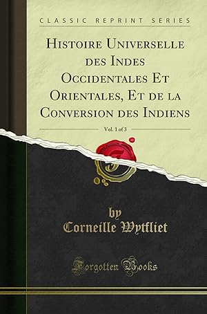
Histoire universelle des Indes, orientales et occidentales.
Published by Douai: Fran�ois Fabri, 1607, 1607
Seller: Arader Galleries - AraderNYC, New York, NY, U.S.A.
Seller rating 5 out of 5 stars
Hardcover. Three parts in one volume, folio (12 x 7 1/2 in.; 30.5 x 19.1 cm). Three engraved titles (the first supplied in facsimile), 19 total engraved double-page maps including a double hemisphere world map after Rumold Mercator (Shirley 207) and 18 maps of the Americas, text within double rules, woodcut initials, head- and tailpieces. BINDING/CONDITION: Later stiff vellum; boards bowed. Lacking two leaves: general title (supplied in facsimile) and blank leaf S4 in Part I, light to moderate intermittent browning, marginal stain on f6 and K4v in Part III dust-soiled. (64V1G) The second edition in French. The first part is extracted and freely translated from the first edition published in Latin (1597). The important series of American maps are printed from the same copper plates, with only very minor changes, primarily to the titles. This edition of the atlas is augmented with an account of the East Indies by Italian astronomer, cartographer and mathematician, Giovanni Antonio Magini (1555-1617). The third part, also by Magini, is a relation of the Jesuit missions and their attempts to convert the indigenous peoples there to Christianity. Wytfliet's atlas had been an immediate success, and over the next two decades six more editions, including three with French text (as here) were published. PROVENANCE: Jean R. Perrette (bookplate and his sale, Christie's New York, 5 April 2016, lot 34) REFERENCES: Alden/European Americana 607/100; Borba de Moraes II, p. 381; JCB (1919) II, p. 48; Phillips, Atlases 1143; Sabin 105700. Note: Sabin does not call for the 4 half-page maps of Japan, India, China and the Philippines present in the 1605 edition, although they are given in Borba de Moraes and JCB. They are not present in this copy.
-
Descriptionis Ptolemaicae augmentum sive occidentis notitia. Brevi commentario illustrata, et hac secunda editione magna sui parte aucta.
Published by Louvain: Gerard Rivius, 1598, 1598
Seller: Arader Galleries - AraderNYC, New York, NY, U.S.A.
Seller rating 5 out of 5 stars
Hardcover. Condition: Very Good. Folio (12 x 7 3/4 in.; 30.5 x 19.7 cm). Engraved architectural title-page surmounted by the Habsburg imperial coat of arms, dedication to Philip III (fol. ***2), notice to the reader (fol. ***3), epigram (fol. ***4r), privileges dated 15 May 1598 and 17 July 1597 (fol. ***4v), table of maps (fol. Aa4v), 19 copper-engraved double page maps interleaved between the preliminaries and the text, woodcut initials and head- and tailpieces, one pagination error (Aa1 reads "158" instead of "185"). BINDING/CONDITION: Contemporary German pigskin over boards roll-tooled in blind stamped with central lozenge on front cover and ecclesiastical arms of a bishop on the lower cover, plain endpapers and edges, traces of two pairs of ties, short crack to joint at foot of spine, extremities rubbed. Ownership inscriptions on title-page partially eradicated, some browning to text, occasional small faint dampstains on lower margins and inside corners of upper margins. (64V1G) AN OUTSTANDING, UNSOPHISTICATED COPY of the second edition, Rivius issue (shared with Johann Bogaerts), of the earliest American atlas, with good, strong impressions of the maps: "Chica sive Patagonica," "Peruani regni descriptio," "Limes Occidentis," "Norumbega et Virginia," and "Nova Francia et Canada" all bear the date of 1597. Wytfliet's atlas, firsts published in 1597 was an immediate success, and six further editions, including three with French text, were published within the next two decades. In this edition all pagination errors but one have been corrected and the errata eliminated. PROVENANCE: B[ibliotheca] Maria[e] in Salem, Convent of the Cistercians of Salem, north of Lake Constance, Germany (contemporary inscription on top margin of title-page); Bibliotheca Minoraugiensis, Premonstratensian Convent of Weissenau in Swabia, near Ravensburg, viz. north of Lake Constance (inscription on lower margin of title-page); Voyages and Travels from the Library of David Parsons (sale, Sotheby's New York, 11 December 2007, lot 96) Arader Galleries gratefully acknowledges the assistance of Dr. Paul S. Needham, Scheide Librarian at Princeton, for determining the details of the early ownership inscriptions REFERENCES: Borba de Moraes 2:381; Alden/European Americana 598/122; Gallup, "Wytfliet's Descriptionis Ptolemaicae Augmentum" in the Papers of the Bibliographical Society of America, 76:1 (1982), pp. 66-67; Koeman III: Wyt 2; Phillips, Atlases 3645; Sabin 105697; cf. Burden, The Mapping of North America 100-107 and Shirley, World 207.
-
![Seller image for Histoire universelle des Indes occidentales divise e en deux livres / faicte en latin par Monseiur Wytfliet ; nouvellement traduicte, ou il est traite de leur descouverte, description, & conqueste faicte tant par les Castillans que Portugais, ensemble de leurs moeurs, religion, gouvernemens, & loix. 1607 [LeatherBound] for sale by S N Books World](https://pictures.abebooks.com/inventory/md/md32213586455.jpg)
Histoire universelle des Indes occidentales divise e en deux livres / faicte en latin par Monseiur Wytfliet ; nouvellement traduicte, ou il est traite de leur descouverte, description, & conqueste faicte tant par les Castillans que Portugais, ensemble de leurs moeurs, religion, gouvernemens, & loix. 1607 [LeatherBound]
Language: French
Publication Date: 2025
LeatheBound. Condition: New. BOOKS ARE EXEMPT FROM IMPORT DUTIES AND TARIFFS; NO EXTRA CHARGES APPLY. Leatherbound edition. Condition: New. Leather Binding on Spine and Corners with Golden leaf printing on spine. Bound in genuine leather with Satin ribbon page markers and Spine with raised gilt bands. Pages: 94. A perfect gift for your loved ones. Reprinted from 1607 edition. NO changes have been made to the original text. This is NOT a retyped or an ocr'd reprint. Illustrations, Index, if any, are included in black and white. Each page is checked manually before printing. As this print on demand book is reprinted from a very old book, there could be some missing or flawed pages, but we always try to make the book as complete as possible. Fold-outs, if any, are not part of the book. If the original book was published in multiple volumes then this reprint is of only one volume, not the whole set. IF YOU WISH TO ORDER PARTICULAR VOLUME OR ALL THE VOLUMES YOU CAN CONTACT US. Resized as per current standards. Sewing binding for longer life, where the book block is actually sewn (smythe sewn/section sewn) with thread before binding which results in a more durable type of binding. Language: French Pages: 94.
-
![Seller image for Histoire universelle des Indes orientales divisee en deux livres / faicte en latin par Antoine Magin, nouvellement traduicte ; contenant la descouverte navigation situation & conqueste faicte tant par les Portugais que les Castillants ensemble leurs moeurs & religion. 1611 [LeatherBound] for sale by S N Books World](https://pictures.abebooks.com/inventory/md/md31376618098.jpg)
Histoire universelle des Indes orientales divisee en deux livres / faicte en latin par Antoine Magin, nouvellement traduicte ; contenant la descouverte navigation situation & conqueste faicte tant par les Portugais que les Castillants ensemble leurs moeurs & religion. 1611 [LeatherBound]
Language: French
Publication Date: 2025
LeatherBound. Condition: New. BOOKS ARE EXEMPT FROM IMPORT DUTIES AND TARIFFS; NO EXTRA CHARGES APPLY. Leatherbound edition. Condition: New. Leather Binding on Spine and Corners with Golden leaf printing on spine. Bound in genuine leather with Satin ribbon page markers and Spine with raised gilt bands. Pages: 89. A perfect gift for your loved ones. Reprinted from 1611 edition. NO changes have been made to the original text. This is NOT a retyped or an ocr'd reprint. Illustrations, Index, if any, are included in black and white. Each page is checked manually before printing. As this print on demand book is reprinted from a very old book, there could be some missing or flawed pages, but we always try to make the book as complete as possible. Fold-outs, if any, are not part of the book. If the original book was published in multiple volumes then this reprint is of only one volume, not the whole set. IF YOU WISH TO ORDER PARTICULAR VOLUME OR ALL THE VOLUMES YOU CAN CONTACT US. Resized as per current standards. Sewing binding for longer life, where the book block is actually sewn (smythe sewn/section sewn) with thread before binding which results in a more durable type of binding. Language: French Pages: 89.
-
![Seller image for Histoire universelle des Indes occidentales divise e en deux livres / faicte en latin par Monseiur Wytfliet ; nouvellement traduicte, ou il est traite de leur descouverte, description, & conqueste faicte tant par les Castillans que Portugais, ensemble de leurs moeurs, religion, gouvernemens, & loix. 1607 [LeatherBound] for sale by S N Books World](https://pictures.abebooks.com/inventory/md/md31376613171.jpg)
Histoire universelle des Indes occidentales divise e en deux livres / faicte en latin par Monseiur Wytfliet ; nouvellement traduicte, ou il est traite de leur descouverte, description, & conqueste faicte tant par les Castillans que Portugais, ensemble de leurs moeurs, religion, gouvernemens, & loix. 1607 [LeatherBound]
Language: French
Publication Date: 2025
LeatherBound. Condition: New. BOOKS ARE EXEMPT FROM IMPORT DUTIES AND TARIFFS; NO EXTRA CHARGES APPLY. Leatherbound edition. Condition: New. Leather Binding on Spine and Corners with Golden leaf printing on spine. Bound in genuine leather with Satin ribbon page markers and Spine with raised gilt bands. Pages: 118. A perfect gift for your loved ones. Reprinted from 1607 edition. NO changes have been made to the original text. This is NOT a retyped or an ocr'd reprint. Illustrations, Index, if any, are included in black and white. Each page is checked manually before printing. As this print on demand book is reprinted from a very old book, there could be some missing or flawed pages, but we always try to make the book as complete as possible. Fold-outs, if any, are not part of the book. If the original book was published in multiple volumes then this reprint is of only one volume, not the whole set. IF YOU WISH TO ORDER PARTICULAR VOLUME OR ALL THE VOLUMES YOU CAN CONTACT US. Resized as per current standards. Sewing binding for longer life, where the book block is actually sewn (smythe sewn/section sewn) with thread before binding which results in a more durable type of binding. Language: French Pages: 118.
-
![Seller image for Histoire universelle des Indes occidentales et orientales, et de la conversion des Indiens divisee en trois parties par Cornille [sic] Wytfliet & Anthoine Magin & autres historiens 1611 [LeatherBound] for sale by S N Books World](https://pictures.abebooks.com/inventory/md/md30638337637.jpg)
Leatherbound. Condition: NEW. BOOKS ARE EXEMPT FROM IMPORT DUTIES AND TARIFFS; NO EXTRA CHARGES APPLY. Leatherbound edition. Condition: New. Leather Binding on Spine and Corners with Golden leaf printing on spine. Bound in genuine leather with Satin ribbon page markers and Spine with raised gilt bands. Pages: 213. A perfect gift for your loved ones. Reprinted from 1611 edition. NO changes have been made to the original text. This is NOT a retyped or an ocr'd reprint. Illustrations, Index, if any, are included in black and white. Each page is checked manually before printing. As this print on demand book is reprinted from a very old book, there could be some missing or flawed pages, but we always try to make the book as complete as possible. Fold-outs, if any, are not part of the book. If the original book was published in multiple volumes then this reprint is of only one volume, not the whole set. IF YOU WISH TO ORDER PARTICULAR VOLUME OR ALL THE VOLUMES YOU CAN CONTACT US. Resized as per current standards. Sewing binding for longer life, where the book block is actually sewn (smythe sewn/section sewn) with thread before binding which results in a more durable type of binding. Language: French Pages: 213.
-
![Seller image for Histoire universelle des Indes occidentales divise e en deux livres / faicte en latin par Monseiur Wytfliet ; nouvellement traduicte, ou il est traite de leur descouverte, description, & conqueste faicte tant par les Castillans que Portugais, ensemble de leurs moeurs, religion, gouvernemens, & loix 1607 [LeatherBound] for sale by S N Books World](https://pictures.abebooks.com/inventory/md/md30638341362.jpg)
Histoire universelle des Indes occidentales divise e en deux livres / faicte en latin par Monseiur Wytfliet ; nouvellement traduicte, ou il est traite de leur descouverte, description, & conqueste faicte tant par les Castillans que Portugais, ensemble de leurs moeurs, religion, gouvernemens, & loix 1607 [LeatherBound]
Language: French
Publication Date: 2025
Leatherbound. Condition: NEW. BOOKS ARE EXEMPT FROM IMPORT DUTIES AND TARIFFS; NO EXTRA CHARGES APPLY. Leatherbound edition. Condition: New. Leather Binding on Spine and Corners with Golden leaf printing on spine. Bound in genuine leather with Satin ribbon page markers and Spine with raised gilt bands. Pages: 255. A perfect gift for your loved ones. Reprinted from 1607 edition. NO changes have been made to the original text. This is NOT a retyped or an ocr'd reprint. Illustrations, Index, if any, are included in black and white. Each page is checked manually before printing. As this print on demand book is reprinted from a very old book, there could be some missing or flawed pages, but we always try to make the book as complete as possible. Fold-outs, if any, are not part of the book. If the original book was published in multiple volumes then this reprint is of only one volume, not the whole set. IF YOU WISH TO ORDER PARTICULAR VOLUME OR ALL THE VOLUMES YOU CAN CONTACT US. Resized as per current standards. Sewing binding for longer life, where the book block is actually sewn (smythe sewn/section sewn) with thread before binding which results in a more durable type of binding. Language: French Pages: 255.
-

Florida et Apalche
Published by Louvain, 1597
Seller: William Chrisant & Sons, ABAA, ILAB. IOBA, ABA, Ephemera Society, Fort Lauderdale, FL, U.S.A.
Association Member: ABAA ESA ILAB
Seller rating 5 out of 5 stars
Condition: Very Good. An engraved map of the Gulf of Mexico, Florida, Georgia, the Carolinas, Bahamas, and Cuba from Cornelis Wytfliet's Descriptionis Ptolemaicae Augmentum and considered one of the earliest maps to focus on Southeast America. The image measures 11.25 x 9 in (28.5 x 23 cm); the page measures 13.5 x 11.75 in (34 x 30 cm). An early inscription to the bottom margin (see image). Scarce.
-
Nova Francia Et Canada 1597
Published by Louvain, Belgium, 1597
Seller: Alexandre Antique Prints, Maps & Books, Toronto, ON, Canada
Seller rating 4 out of 5 stars
Map
Condition: Very Good. First State. The last of the eight maps relating to North America in Cornelis Wytfliet's first atlas of the New World. It is the first to use Canada in its title, and the first to concentrate on the river and Gulf of St. Lawrence. It summarizes sixteenth century knowledge of the area just prior to the expansion of France here, and the voyages of Samuel de Champlain.Cornelius Wytfliet or Cornelis van Wytfliet (died in 1597) was a geographer from Leuven in the Habsburg Netherlands. He was best known for producing the first atlas of the Americas with 19 double page engraved maps., Size : 237x298 (mm), 9.33x11.73 (Inches), Black & White, 0.
-
Norumbega et Virginia; 1597 Important first state map of the East Coast of North America
Published by Cornelis van Wytfliet, Louvain, 1597
Seller: Argosy Book Store, ABAA, ILAB, New York, NY, U.S.A.
Seller rating 5 out of 5 stars
Map. Copper-plate engraving. Image measures 11.25" x 9.25". This important 1597 map is from the first atlas of the New World by Cornelis van Wytfliet. Sold as is, the map is missing 1/4 inch of the center margin with text loss. Overall and some wear abrasion to border in between 42 and 43 degrees on the center left margin.The atlas contains some of the first printed maps of the New World as well as a history of the voyages of Columbus, Pizarro, Verrazano and other explorers. This map depicts the East Coast of the North America from the Outer Banks of North Carolina to the Canada. The map is only the second map to use 'Virginia' as part of its title and was the most accurate map of the region until Joannes de Laet published his 1630 map 'Nova Anglia, Novvm Belgivm Et Virginia'. At the time, the name 'Virginia' referred to the entire Mid-Atlantic region. The map shows the early knowledge of the region (or lack thereof) just prior to the English voyages of discovery and settlement. Long Island and Cape Cod, two of the most prominent geographical features of the region are missing from the map, so is Hudson River. Because of the notoriously perilous waters around New England and Cape Cod and the Carolina Outer Banks, the regions between Nova Scotia and Virginia were usually avoided and hence poorly mapped. Other anomalies follow some inaccuracies from earlier maps, resulting in the entire coastline pushed northward by about 5 degrees. Chesapeake Bay appears too far north of its actual position, near present day southern Maine. What could be Cape Hatteras appears here as C. de las arenas also placed further north. The most fascinating highlight of the map is the name Norumbega which appears on the map. This name appeared on several maps as the name for Northeastern America until John Smith's 1614 map noted the territory as New England. The mythical city at the head of the Penobscot Bay, believed to be an American Indian fur trading city, also named Norumbega is identified. Several legends about the city of Norumbega have been recorded. Some accounts suggest the existence of the French trading fort at the site, while others state that it was a place of great wealth. Some accounts also claim that the name was derived from 'Norvegr' suggesting that it was a Viking city, hence linking it to early Viking settlements in North America. Regardless of the truth, this map is a exceptional example of the early mapping of the region. This is the first state of the map, identified by the left side latitudinal mark reading 30 instead of 39 and, and dated 1597. A beautifully engraved compass rose adorns the map. Cornelius Wytfliet (1555--1597) was a Belgian cartographer who dedicated his work to Philip III of Spain. His 'Descriptionis Ptolemaicae augmentum', where this map is from, provided a systematic description of the the Americas. He used the writings of both historians and contemporary geographers to render the geography natural history, and European discovery of the Americas. This map is a fine example of his work. Burden 103 State 1. This map in its first state is fundamental in the history of the mapping of the East Coast of North America.
-
Descriptionis Ptolemaicae augmentum sive occidentis notitia. Brevi commentario illustrata, et hac secunda editione magna sui parte aucta.
Published by Louvain: Gerard Rivius, 1598, 1598
Seller: Arader Galleries - AraderNYC, New York, NY, U.S.A.
Seller rating 5 out of 5 stars
Folio (12 x 7 1/2 in.; 30.5 x 19.1 cm). Engraved architectural title-page surmounted by the Habsburg imperial coat of arms, dedication to Philip III (fol. ***2), notice to the reader (fol. ***3), epigram (fol. ***4r), privileges dated 15 May 1598 and 17 July 1597 (fol. ***4v), table of maps (fol. Aa4v), 19 copper-engraved double page maps interleaved in the text, woodcut initials and head- and tailpieces, one pagination error (Aa1 reads "158" instead of "185"). BINDING/CONDITION: Contemporary limp vellum, yapp edges, modern green silk ties, contemporary titling on spine. Linen folding case, black morocco lettering piece on spine. Light to moderate browning throughout, text offsetting to verso of map of Florida. (64V1G) A GOOD, UNSOPHISTICATED COPY of the second edition, Rivius issue (shared with Johann Bogaerts), of the earliest American atlas. "Chica sive Patagonica," "Peruani regni descriptio," "Limes Occidentis," "Norumbega et Virginia," and "Nova Francia et Canada" all bear the date of 1597. Wytfliet's atlas, firsts published in 1597, was an immediate success, and six further editions, including three with French text, were published within the next two decades. In this edition all pagination errors but one have been corrected and the errata eliminated.PROVENANCE: Antonis Orsetti, Luca (near contemporary inscription on recto of front free endpaper partially obscuring another, together with a manuscript location guide to the maps) REFERENCES: Borba de Moraes 2:381; Alden/European Americana 598/122; Gallup, "Wytfliet's Descriptionis Ptolemaicae Augmentum" in the Papers of the Bibliographical Society of America, 76:1 (1982), pp. 66-67; Koeman III, Wyt 2; Phillips, Atlases 3645; Sabin 105697; cf. Burden, The Mapping of North America 100-107 and Shirley, World 207.
-
Hispania Nova (Mexico)
Published by Louvain, 1597
Seller: Arader Galleries of Philadelphia, PA, Philadelphia, PA, U.S.A.
Seller rating 4 out of 5 stars
N/A. Condition: Very Good. Dust Jacket Condition: N/A. Engraving with original hand-color. Sheet size: 11 1/2 x 14 1/2". Inventory#: p1400pmat.
-
Estotilandia Et Laboratoris Terra
Published by A Douay: Aux despens de Fran�ois Fabri, 1605., 1605
Seller: Arader Galleries - AraderNYC, New York, NY, U.S.A.
Seller rating 5 out of 5 stars
First Edition
1st Edition. Single sheet (10 6/8 x 13 inches; 9 x 11 inches to the neat line). Fine engraved map centered on the Davis Strait, showing Greenland, the extreme northeast of Canada, Iceland, and the mythical island of Frisland, the title within a fine strapwork and allegorical cartouche upper left (pale marginal stains, one or two spots). From the first French edition of Wytfliet's "Descriptionis Ptolemaicae augmentum", "Histoire Vniverselle des Indes". A Douay: Aux despens de Fran�ois Fabri, 1605. Including the mythical map of Frisland which appeared on virtually all of the maps of the North Atlantic from the 1560s through the 1660s, until French and English navigators explored the area. "The map's importance comes from its concentration on the area of the English voyages of Frobisher and Davis; they are depicted here in greater detail than before. Clearly derived from Cornelis Claes Nova Francia of 1594, Wytfliet interestingly draws upon the inset on it for the area of Labrador which had offered an alternative representation to the main map. Some information is shown twice on this map as both Frobisher and Davis visited the same shores but were unaware of the fact" (Burden 101). Kohl 113. Phillips, America, p. 303. Trudel, Atlas de la Nouvelle France, p. 65. Van der Krogt (editor), Koeman's Atlantes Neerlandici 371:11:19 (illustrated 9110:371). Dorothy Sloan, Sale 23, April 4th, 2013, lot 15.
-
Limes Occidentis Quiuira et Anian. 1597
Published by A Douay: Aux despens de Fran�ois Fabri, 1605., 1605
Seller: Arader Galleries - AraderNYC, New York, NY, U.S.A.
Seller rating 5 out of 5 stars
First Edition
1st Edition. Single sheet (10 6/8 x 13 inches; 9 x 11 inches to the neat line). Fine engraved map of the west coast of North America, the title within a plain cartouche lower left, decorated with a large and detailed compass rose (pale marginal staining). From the first French edition of Wytfliet's "Descriptionis Ptolemaicae augmentum", "Histoire Vniverselle des Indes". A Douay: Aux despens de Fran�ois Fabri, 1605. Showing the "entire coastal portions of the present day United States and Canada. The general shape derives from that of Mercator's world map of 1569, with a pronounced bulge coincidentally similar to that of Alaska as we know it today, but latitudinally larger so that its south coast is at about 40 degrees. all of the coast above approximately C.Medocino was yet to be visited by Europeans and it was left to Captain James Cook, 180 years later, to first accurately chart these waters. South of this the Spanish had made a number of exploratory voyages starting in the 1530s" (Burden 107). Kohl 282. Lowery 85n. Phillips, America, p. 558. Van der Krogt (editor), Koeman's Atlantes Neerlandici 371:11:14 (illustrated 9190.371.1). Wagner, Cartography of the Northwest Coast #189 (p. 292). Dorothy Sloan, Sale 23, April 4th, 2013, lot 15.
-
Norvmbega Et Virginia. 1597
Published by A Douay: Aux despens de Fran�ois Fabri, 1605., 1605
Seller: Arader Galleries - AraderNYC, New York, NY, U.S.A.
Seller rating 5 out of 5 stars
First Edition
1st Edition. Single sheet (10 6/8 x 13 inches; 9 x 11 inches to the neat line). Fine engraved map of the northeastern coast of North America from Virginia to Cape Breton in New France, the title within a plain cartouche upper left, decorated with a large detailed compass rose to the lower right (one or two marginal spots). Burden's first state with the left latitudinal mark reads 30 instead of 39. From the first French edition of Wytfliet's "Descriptionis Ptolemaicae augmentum", "Histoire Vniverselle des Indes". A Douay: Aux despens de Fran�ois Fabri, 1605. Showing the eastern seaboard of North America from Cape Breton south to the Outer Banks of North Carolinas, described by Burden as "the most accurate map of the east coast until de Laet", this makes an interesting comparison with the Smith map of New England, with its contraction of the New England, New Jersey and Virginia region. The great city of "Norumbega" prominent to the right of the title, an early New England misconception, is generally thought to represent the Penobscot region in Maine. Thus this map omits completely Cape Cod, New York, Long Island and New Jersey, with the next "recognisable" feature to the south being "Chesipooc Bay", although not the Chesapeake Bay as we know it today, or as mapped by Smith in 1608. Cornelis van Wytfliet, secretary to the Council of Brabant, called his atlas of the New World a supplement to Ptolemy's "Geography", although the two works are actually quite separate. Dedicated to King Philip III of Spain, and covering the history of the first European encounters with the New World, its geography, and natural history. Wyfliet used as his source the works of Acosta, Hakluyt, de Bry and Ramusio. Burden 103; JCB, Early American Images 0854-1. Cumming, The Southeast in Early Maps 19. Danforth, The Land of Norumbega: Maine in the Age of Exploration and Settlement 49. McCorkle, New England in Early Printed Maps 597.3 (illustrated, p. 14). Phillips, America, p. 558. Phillips, Virginia Cartography, pp. 18-19. Schwartz & Ehrenberg, The Mapping of America, Plate 40 (p. 80). Stokes, Iconography of Manhattan Island, 1915-28, II, Plate 20. Van der Krogt (editor), Koeman's Atlantes Neerlandici 371:11:17 (illustrated 9200:371.1 & 2). Dorothy Sloan, Sale 23, April 4th, 2013, lot 15.