Maps, Pictorial Map (Over 1,700 results)

Published by Cline Photos
- Softcover
- Map
Seller: Smokey Mountain Bookman, Franklin, NC, U.S.A.Smokey Mountain Bookman
Contact seller5-star sellerCondition: Used - Very good
US$ 9.00
US$ 5.00 shippingShips within U.S.A.Quantity: 1 available
Softcover. Condition: Very Good. [Cline Photos staff.] SOUVENIR PICTORIAL MAP OF THE GREAT SMOKY MOUNTAINS NATIONAL PARK. Chattanooga, Tenn: (1971). Largecolor map. Color map on one side; map plus text on the other side. Full color photographs. 4 1/2" wide x 11" tall folded and opens to circa 22" widex 36" long. Unmarked, clean…and properly folded. Protected in a clear envelope with backing board. In very good condition.
 More images
- Hardcover
- First Edition
- Map
Seller: N. G. Lawrie Books, sheffield, United KingdomN. G. Lawrie Books
Contact seller5-star sellerCondition: Used - Very good
US$ 20.39
US$ 12.54 shippingShips from United Kingdom to U.S.A.Quantity: 1 available
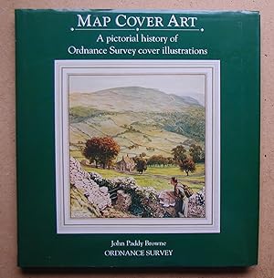
Hardcover. Condition: Very Good+. Dust Jacket Condition: Very Good. First Edition. 144pp, colour illustrations. DW has slight shelf wear. Size: 4to - over 9¾" - 12" tall.

Language: English
- Map
Seller: Novelty Shop Used & Rare Books, Novelty, OH, U.S.A.Novelty Shop Used & Rare Books
Contact seller5-star sellerNo Binding. Condition: Fine. A collector of Ohio memorabilia will find this pictorial map intriguing. The design highlights the presidents from Ohio as well as the colleges & universities located in the state. This map is new old stock. It is not a reproduction or a modern copy. This map has been in storage over 50 years and is…in mint condition. A number of years ago I had an opportunity to purchase the estate of a northern Ohio artist named Arthur Suchy. Mr. Suchy was born in Cleveland in 1899 and died in Chagrin Falls, Ohio in 1995. Although he supported himself as a graphic designer, he had a personal interest in cartography. In his effects, I found examples of at least six maps that he designed. He had them printed and sold them in local gift shops. The copies that did not sell he returned to his home and stored in his studio. This map is one of the unsold copies. The map measures 24" by 24" and is ready to frame. It is printed in four colors of ink on medium weight paper. The map is entitled "Ohio, Mother of Presidents". Although it was designed and copyrighted in 1939, I believe this to be a later printing, perhaps from the 1970s. 48 College seals will be found in the circles along the border and elsewhere on the map. A line leads from each seal to the town in which the college is located. A line leads from each presidential portrait to the town in which he was born. Alternating with the seals in the border are squares in which will be found the derivation of the names of the various counties in Ohio. The border includes the seals of the college of Wooster, Ashland College, Findlay College, Miami University, Case, Hiram, Akron, Ohio Northern, Ohio Wesleyan, Defiance, Ohio State, Oberlin, John Carroll, Denison, Capital, Mount Union, Xavier and many others. Suchy, Arthur B. (illustrator).
Published by Ordnance Survey London: 1991
- Map
Seller: AMBRA BOOKS (Aitchison & Cornish), Bristol, United KingdomAMBRA BOOKS (Aitchison & Cornish)
Contact seller3-star sellerCondition: Used
US$ 9.52
US$ 25.08 shippingShips from United Kingdom to U.S.A.Quantity: 1 available
Illusts, 144pp, dustwrapper. --- Please e-mail for one of my FREE CATALOGUES which include - ( History - Topography - Genealogy - Natural History - Biography - Mining - Dialect - Language - etc. ).
 More images
Language: English
Published by Intourist, Saint Petersburg 1965
- Softcover
- Map
- International Edition
Seller: Recycled, Corte Madera, CA, U.S.A.Recycled
Contact seller5-star sellerInternational EditionCondition: Used - Very good
US$ 65.00
US$ 7.00 shippingShips within U.S.A.Quantity: 1 available
Soft cover. Condition: Very Good. 5th or later Edition, International Edition. Printed cover front is cut short, the folded map has a couple fold tears, but is in overall very nice condition. I base my information on the David Rumsey Map Collection at Stanford entry, even though this map was originally published in 1930 Internat…ional Edition.
 More images
- Map
Seller: Blind-Horse-Books (ABAA), DeLand, FL, U.S.A.Blind-Horse-Books (ABAA)
Contact seller5-star sellerCondition: Used - Very good
US$ 24.00
US$ 6.00 shippingShips within U.S.A.Quantity: 1 available
Condition: Very Good. A premier example of mid-century promotional cartography, issued at the height of Florida?s mid-century boom.? This 1954 official road map serves as both a functional navigational tool and a sophisticated piece of travel marketing. The interior unfolds to a massive 30 x 25.5-inch state map, surrounded by ph…otographic vignettes of Hugh Taylor Birch State Park, the singing tower at Lake Wales, and Seminole life in the Everglades. By blending technical highway data with aspirational lifestyle imagery, the Florida State Road Department created a document that sold the Sunshine State as much as it mapped it. This specimen documents a pivotal moment in American history when the family automobile became the primary vehicle for cultural discovery. KEY FEATURES +++ Cartography: Detailed statewide highway map with 8 city-specific insets including Miami, Pensacola, and the Tampa/St. Petersburg/Clearwater hub. +++ Visuals: Features 15+ color photographic panels and a striking lithographic cover of a sunlit beach framed by palm trees. +++ Technical Data: Includes a 1950 Census-based population index, mileage charts, and a "Passing Regulations" guide with period-correct safety illustrations. +++ Nostalgia Factor: Contains a "Welcome to Florida" message from then-Governor Charley E. Johns and Chairman Richard H. Simpson. +++ Specs: Folded: 5 x 8.5 inches; Unfolded: approx. 30 x 25.5 inches. CONDITION: Very Good. +++ Color: Lithographic printing remains clean and bright with strong color retention throughout. +++ Structure: No major tears or significant losses at the cross-folds, which is rare for this format. +++ Note: The map has been somewhat carelessly refolded by a previous owner, resulting in minor additional creasing, though it remains flat and presentable. SCHOLARLY FEATURES +++ History of Tourism: Illustrates the 'State-as-Brand' philosophy used to draw Northern tourists during the winter months. +++ Civil Engineering: Records the state?s primary and secondary road systems just prior to the massive changes brought by the 1956 Federal Aid Highway Act. +++ Conservation Record: Provides a checklist of National and State Parks, Forests and State Monuments, documenting early efforts to balance development with preservation. HISTORICAL SIGNIFICANCE ? In 1954, Florida was undergoing a radical identity shift. The state was moving away from its agrarian roots and toward a service-based economy centered on the Seasonal Visitor. This map is the blueprint for that transformation. From the 'Meanings of Florida Indian Names' to the lawful speed limits, every panel was designed to make the unfamiliar terrain of the South feel accessible, safe, and exciting for the post-war middle class. SUBJECTS: Florida Tourism, Road Culture, Cartography, 1950s Americana, Highway Development, Travel Ephemera, Mid-Century Design, Ephemera, Map, Travel Literature.
Language: German
Published by Hallwag AG, Bern / Schweiz, 1979
- Map
Seller: Clerc Fremin, Steingaden, GermanyClerc Fremin
Contact seller5-star sellerCondition: Used
US$ 9.39
US$ 25.23 shippingShips from Germany to U.S.A.Quantity: 1 available
Faltkarte. 1 Seite Zustand: Keine Beschädigungen, keine Eintragungen. Rücken, Ecken, Kanten bestoßen. Sprache: Deutsch Gewicht in Gramm: 150.
Published by Southampton?: Ordnance Survey 1990
- Hardcover
- Map
Seller: Barry McKay Rare Books, Appleby-in-Westmorland, CUMBR, United KingdomBarry McKay Rare Books
Contact seller5-star sellerAssociation member: PBFA
Condition: Used
US$ 21.75
US$ 31.68 shippingShips from United Kingdom to U.S.A.Quantity: 1 available
Sm.4to (248x232mm), 144p. 392 illustrations (mostly coloured). An excellent copy in original hardback boards, dustjacket. A wonderful pictorial survey of the wide range of covers for the Ordnance Survey's various series of British maps.

Language: English
- Map
Seller: Novelty Shop Used & Rare Books, Novelty, OH, U.S.A.Novelty Shop Used & Rare Books
Contact seller5-star sellerNo Binding. Condition: Fine. Any collector of Key West, Florida memorabilia will be interested in this unusual pictorial map. This over seventy-five-year-old map is new old stock. It has been in storage for over 60 years and is in mint condition. It is not a reproduction or a modern copy. This map provides a unique view of the i…sland and notes the locations of 82 places of interest. A number of years ago I had an opportunity to purchase the estate of a northern Ohio artist named Arthur Suchy. Mr. Suchy was born in Cleveland in 1898 and died in Chagrin Falls, Ohio in 1995. Although he supported himself as a graphic designer, he had a personal interest in cartography. In his effects, I found examples of at least six maps that he designed. He had them printed and sold them in local gift shops. The copies that did not sell he returned to his home and stored in his studio. This map is one of the unsold copies. The map measures 22" by 18" and is ready to frame. It is printed in red ink on medium weight paper. The map is entitled "Key West Florida". It was created and copyrighted in 1938. A note at the bottom indicates that this is the second edition of the map. In addition it states that a larger Collector's edition of the map, limited to one hundred copies and hand-colored was available. This copy has not been colored and I no longer have copies of the Collector's edition available. Suchy, Arthur B. (illustrator).

Language: English
- Map
Seller: Novelty Shop Used & Rare Books, Novelty, OH, U.S.A.Novelty Shop Used & Rare Books
Contact seller5-star sellerNo Binding. Condition: Fine. Any collector of Cleveland memorabilia will be interested in this ready-to-frame pictorial map. This map is new old stock. It is not a reproduction or a modern copy. This nearly ninety-year-old map provides a unique view of the city and is in mint condition. A number of years ago I had an opportunity… to purchase the estate of a northern Ohio artist named Arthur Suchy. Mr. Suchy was born in Cleveland in 1899 and died in Chagrin Falls, Ohio in 1995. Although he supported himself as a graphic designer, he had a personal interest in cartography. In his effects, I found examples of at least six maps that he designed. He had them printed and sold them in local gift shops. The copies that did not sell he returned to his home and stored in his studio. This map is one of the unsold copies. It has been in storage for over 60 years and is in fine condition. The map measures 17" by 20" and is printed in brown ink on medium weight paper. It depicts the center of Cleveland and Ohio City in 1836. The map was drawn by Mr. Suchy in the 1930s and is copyrighted 1937. Suchy, Arthur B. (illustrator).
 More images
Language: English
Published by Salt Lake City, Utah: Selbstverlag, ca. 1946
- Softcover
- Map
Seller: Antiquariat im Kloster, Weilheim, BY, GermanyAntiquariat im Kloster
Contact seller4-star sellerCondition: Used - Very good
US$ 30.51
US$ 68.35 shippingShips from Germany to U.S.A.Quantity: 1 available
Condition: Gut. Mehrfarb. Faltkarte von N.Y. mit Nebenkarte Lower N.Y. and Long Island. 68x67 cm. Maßstab: 1cm = 3,33 Miles. Rückseitig: Sehenswürdigkeiten von N.Y. und 6 Nebenkarten. - Karte etw. fleckig und mit minimalen Randläsuren an den Faltkanten, sowie eine von Hand eingezeichnete Route von N.Y. bis Keeseville. Zahlungen…mit PayPal möglich. Sprache: Englisch Gewicht in Gramm: 185 OBrosch. Faltmaß 17,5 x 8,5 cm.
 More images
- Softcover
- Map
Seller: RareMapsandBooks, Dover, NH, U.S.A.RareMapsandBooks
Contact seller4-star sellerCondition: Used - Fair
US$ 30.00
US$ 6.95 shippingShips within U.S.A.Quantity: 1 available
Condition: Fair. (Old Brochures, Americana, Travel, Tourism, New York, Long Island, State Parks, Illustrated Brochures, Brochures with Maps). Long Island State Parks. Published 1939, New York by Western PRTG & Litho. Folding brochure issued as a World's Fair promotional. Text in English. Illustrated throughout. Map on rear. Publ…isher's pictorial paper wrappers folded into panels, printed on both sides. Item is over 100 years old and shows some signs of handling and time. Item is not new or in "new" condition. Paper gently age worn, slight rubbing, remains overall clean and attractive as a fragile survival. Paper is lightly toned, signs of handling, small scattered spotting, internally still well preserved, tight, sound. Still attractive on the shelf. The scarce item displays a pleasing and unique age patina and overall is in nice antiquarian condition, any age flaws easy to overlook or forgive. Please review photos for more detail and our best attempt to convey how this offering survives. Covers measures c. 9 1/4" H x 4" W.[B12658].
 More images
- Softcover
- Map
Seller: RareMapsandBooks, Dover, NH, U.S.A.RareMapsandBooks
Contact seller4-star sellerCondition: Used - Good
US$ 30.00
US$ 6.95 shippingShips within U.S.A.Quantity: 1 available
Condition: good. (Old Books, Travel, Tourism, 20th Century Books, Promotional Books, Illustrated Books, Panama). Visit Panama. Published 1958, Washington, D. C. by Pan American Union Travel Division.32 pages plus wrapper covers. Text in English. Illustrated throughout with many b&w photos. Publisher's pictorial paper wrappers, p…ictorial cartoon map at centerfold. Item is old and shows some signs of handling and time. Item is not new or in "new" condition. Paper gently age worn, slight rubbing, remains overall clean and attractive as a fragile survival. Paper is lightly toned, signs of handling, small scattered spotting, internally still well preserved, tight, sound. Still attractive on the shelf. The scarce item displays a pleasing and unique age patina and overall is in nice antiquarian condition, any age flaws easy to overlook or forgive. Please review photos for more detail and our best attempt to convey how this offering survives. Covers measures c. 9" H x 6" W.[B12469].
 More images
- Softcover
- Map
Seller: RareMapsandBooks, Dover, NH, U.S.A.RareMapsandBooks
Contact seller4-star sellerCondition: Used - Good
US$ 30.00
US$ 6.95 shippingShips within U.S.A.Quantity: 1 available
Condition: good. (Old Maps, 20th Century Maps, Americana, Travel, Tourism, United States, Eastern Air Lines, Florida, Bahamas, Mexico, Cuba ). Presenting the Greatest Vacation Values in the World! Eastern Air Lines "Happy Holidays" Low-Cost Luxury Vacations For Any Budget. Published c. 1950, United States by Eastern Air Lines. F…olding advertising brochure, printed on both sides of the sheet. Text in English. Cartoon pictorial map. Map is vintage and shows some signs of handling and time. Sheet is not new or in "new" condition. Tourist map issued as a guide to highlight this company's vacation packages. Tourist information & advertising. Paper gently age worn, slight rubbing, remains overall clean and attractive as an ephemeral survival. Map displays a pleasing and unique age patina and overall is in nice antiquarian condition, any age flaws easy to overlook or forgive. Please review photos for more detail and our best attempt to convey how this ephemeral cartographic item survives. Original fold lines as issued. Brochure unfolded measures c. 27" H x 16" W.[B9892].
 More images
- Softcover
- Map
Seller: RareMapsandBooks, Dover, NH, U.S.A.RareMapsandBooks
Contact seller4-star sellerCondition: Used - Good
US$ 30.00
US$ 6.95 shippingShips within U.S.A.Quantity: 1 available
Condition: good. (Old Pamphlets, 20th Century Pamphlets, Europe, British Islands, Scotland, Trossachs, Travel, Tourism, Illustrated Pamphlets, Pamphlets with Maps). Through the Trossachs. Published 1950, Glasgow, United Kingdom by Mc Corquodale & Co. Folding tourist promotional brochure. Text in English. Illustrated throughout i…ncluding a full page transportation map showing routes for train, steamer and motor cars. Publisher's pictorial paper wrappers folded into panels, printed on both sides. Item is over 100 years old and shows some signs of handling and time. Item is not new or in "new" condition. Paper gently age worn, slight rubbing, remains overall clean and attractive as a fragile survival. Paper is lightly toned, signs of handling, small scattered spotting, internally still well preserved, tight, sound. Still attractive on the shelf. The scarce item displays a pleasing and unique age patina and overall is in nice antiquarian condition, any age flaws easy to overlook or forgive. Please review photos for more detail and our best attempt to convey how this offering survives. Covers measures c. 9" H x 4" W.[B12160].
 More images
Published by Union Oil Company 1940
- Map
Seller: Chamblin Bookmine, Jacksonville, FL, U.S.A.Chamblin Bookmine
Contact seller5-star sellerCondition: Used - Good
US$ 30.00
US$ 6.99 shippingShips within U.S.A.Quantity: 1 available
8vo Map. Condition: Good. Vintage brochure featuring a pictorial map of California and Nevada, alongside small route maps of the Bay Area and Los Angeles, issued by Union Oil Company of California. Colorful illustrations show many sites: La Jolla Caves, movie studios and Griffith Observatory in Los Angeles, the Rose Bowl, Santa…Cruz Beach, Chinatown and Golden Gate Park in San Francisco, parks and missions throughout the region, and more. Places of interest and events in the two states are enumerated, including the Nevada State Fair held at the time in Fallon. The verso has a road map of California and Nevada underneath the National Safety Council's, "Be Careful! The life you save may be your own!" slogan. Triton premium motor oil cans anchor the border's four corners. A few small holes present on creases, as pictured. Minor soiling on backside. Corners lightly bumped. 18.75 x 30 inches.
Published by National Geographic, Washington 1977
- Map
Seller: Sleepy Hollow Books, Huntington, VT, U.S.A.Sleepy Hollow Books
Contact seller5-star sellerCondition: Used - Good
US$ 4.00
US$ 3.99 shippingShips within U.S.A.Quantity: 1 available
Map. Condition: Good. Pictorial folded map, solid. U . S. History.
 More images
Published by 0
- Hardcover
- Map
Seller: RareMapsandBooks, Dover, NH, U.S.A.RareMapsandBooks
Contact seller4-star sellerCondition: Used - Good
US$ 42.50
US$ 6.95 shippingShips within U.S.A.Quantity: 1 available
Condition: good. (Old Books, 20th Century Books, Reproductions, Atlases, Netherlands, Books with Maps, Reference Books, Map Collecting). Caeten van all de Neder-Landen. Originally published 1617, Utrecht by van Herwijk. Mid- to late 20th century reproduction (c.1960-70's?). c. 250 pages. Text in Dutch. Profusely illustrated thro…ughout (a plate book with endless reproductions of rare maps and views). Publisher's pictorial paper covered boards. Book is physically old and shows some signs of handling and time. Book is not new or in "new" condition. Binding gently age worn, mostly light or inoffensive signs of handling and time but nothing severe or unsightly, small thin strip of tape removal at spine base (easy to overlook), book remains overall attractive as an object. Paper is gently toned, still clean, tight, sound internally. Still attractive on the shelf. The book displays a pleasing and unique age patina and is in overall nice antiquarian condition, any age flaws which may be present seem easy to overlook or forgive. Please review photos for more detail showing how this book survives. The asking price reflects the condition based on our examination and 35+ years full time exposure to antiquarian books, maps and printed ephemera of all types and genres. Flaws seen and/ or described have been taken into account. Book Measures c. 13 3/4" H x 9 1/2" W.[B12732].
 More images
Language: English
Published by Ed J Burrow & Co, United Kingdom 1927
- Softcover
- Map
Seller: Pendleburys - the bookshop in the hills, Llanwrda, United KingdomPendleburys - the bookshop in the hills
Contact seller5-star sellerCondition: Used - Good
US$ 15.56
US$ 15.18 shippingShips from United Kingdom to U.S.A.Quantity: 1 available
paperback. Condition: Good. No Jacket. paperback, second edition, pictorial card covers, undated, but we think about 1927-1930, wear to the semi-yapp edges. Mild foxing, the binding tight, free from marking. Illustrated route plans, advertisements. A good copy.

Published by Geographers' Map Co Ltd, London (undated)
- Softcover
- Map
Seller: CURIO, Cleethorpes, North East Lincolnshire, United KingdomCURIO
Contact seller5-star sellerCondition: Used - Very good
US$ 28.55
US$ 39.60 shippingShips from United Kingdom to U.S.A.Quantity: 1 available
Soft cover. Condition: Very Good. No Jacket. Undated, 2/6 printed on front cover. Wear to cover edges, no damage to cloth map, no holes or wear to folds. (22/2).

Suffolk. Aldeburgh to Harwich
From Ward Lock & Co's Pictorial and Descriptive Guide to the Suffolk Coast
Published by 1905-6 1905
- Map
Seller: theoldmapman, Clevedon, SOMER, United Kingdomtheoldmapman
Contact seller5-star sellerCondition: Used
US$ 5.44
US$ 8.58 shippingShips from United Kingdom to U.S.A.Quantity: 1 available
Single sheet. Original antique coloured map. Four original folds. Edge tear in the sea now closed. 26.5 x 22.5 cm.

Suffolk. Aldeburgh to Covehithe
From Ward Lock & Co's Pictorial and Descriptive Guide to the Suffolk Coast
Published by 1905-6 1905
- Map
Seller: theoldmapman, Clevedon, SOMER, United Kingdomtheoldmapman
Contact seller5-star sellerCondition: Used
US$ 5.44
US$ 8.58 shippingShips from United Kingdom to U.S.A.Quantity: 1 available
Single sheet. Original antique coloured map. Three original folds. 17 x 22.5 cm.
 More images
Language: English
Published by Catherall & Prichard,, Chester 1879
- Softcover
- First Edition
- Map
Seller: Andrew Cox PBFA, Shropshire, United KingdomAndrew Cox PBFA
Contact seller5-star sellerAssociation member: PBFA
Condition: Used - Good
US$ 101.96
US$ 25.74 shippingShips from United Kingdom to U.S.A.Quantity: 1 available
Soft cover. Condition: Good. 1st Edition. Published circa 1879 this is a scarce original Victorian folding paper map of the City of Chester bound in its original pictorial paper wrappers, closed the map measures 6.5 inches by 4 inches approx., and fully opened it measures 23.5 inches by 18.5 inches approx. The map features vigne…tte illustrations around its borders depicting Chester's most prominent 19th century landmarks. CONDITON The map has several splits along fold lines, with some old gummed paper strengthening repairs to rear, small edge tears with no loss. There are a couple of annotations to the map in old Victorian ink, (see pictures) else an acceptable example of this scarce survival in the original paper covers. This is a lighter item, overseas shipping costs will be reduced at checkout where possible.

- Softcover
- Map
Seller: J J Basset Books, bassettbooks, bookfarm.co.uk, Peter Tavy, United KingdomJ J Basset Books, bassettbooks, bookfarm.co.uk
Contact seller3-star sellerCondition: Used - Very good
US$ 5.44
US$ 26.40 shippingShips from United Kingdom to U.S.A.Quantity: 1 available
Pictorial Card. Condition: VERY GOOD ( AVERAGE). No Jacket. 5th Revision. Street maps of 37 towns with index, Road maps with index, Population Gazetteer, Administrative Districts and Postcode Districts. FEEL FREE TO E-MAIL FOR PHOTOGRAPHS AND FURTHER DETAILS. FROM A DEALER WHO TELLS YOU WHO THEY ARE AND WHAT THEIR TELEPHONE AND…ADDRESS CONTACT DETAILS ARE. Maps and Index to Streets (illustrator). Not Inscribed or Signed.
 More images
- Softcover
- Map
Seller: RareMapsandBooks, Dover, NH, U.S.A.RareMapsandBooks
Contact seller4-star sellerCondition: Used - Good
US$ 32.50
US$ 6.95 shippingShips within U.S.A.Quantity: 1 available
Condition: good. (Old Books, 20th Century Books, Canada, Travel, Tourism, Yukon Territory, Illustrated Books, Books with Maps). North of the Artic Circle: White Pass and Yukon Route. Published c. 1939- early 40's, Seattle, Washington by J. G. Blanchard.38 pages plus wrappers. Text in English. Illustrated throughout. Route map on… rear cover. Publisher's oblong pictorial paper wrappers. Book is physically old and shows some signs of handling and time. Book is not new or in "new" condition. Binding gently age worn, mostly light or inoffensive signs of handling and time but nothing severe or unsightly, book remains overall attractive as an object. Paper is gently toned, still clean, tight, sound internally. Still attractive on the shelf. The booklet displays a pleasing and unique age patina and is in overall nice antiquarian condition, any age flaws which may be present seem easy to overlook or forgive. Please review photos for more detail showing how this book survives. The asking price reflects the condition based on our examination and 35+ years full time exposure to antiquarian books, maps and printed ephemera of all types and genres. Flaws seen and/ or described have been taken into account. Book Measures c. 3 1/2" H x 6" W.[B7254].
 More images
- Softcover
- Map
Seller: RareMapsandBooks, Dover, NH, U.S.A.RareMapsandBooks
Contact seller4-star sellerCondition: Used - Good
US$ 32.50
US$ 6.95 shippingShips within U.S.A.Quantity: 1 available
Condition: good. (Old Maps, 20th Century Maps, Americana, Virginia, Maryland, Illustrated Pamphlets, Travel, Tourism). Historical Map of Virginia and Adjacent Maryland Showing the Main Points of Historic Interest and the Main Traveled Automobile Routes. Published c. 1960's, Richmond, Virginia by State Commission on Conservation…and Development. Folding pamphlet. Text in English. Illustrated throughout. Publisher's pictorial paper wrappers folded into panels, printed on both sides. Item is old and shows some signs of handling and time. Item is not new or in "new" condition. Sheet remains overall clean and attractive as a fragile survival. Paper is lightly toned, signs of handling, still well preserved, tight, sound. Still attractive on the shelf. The scarce map/ pamphlet displays a pleasing and unique age patina and is in nice antiquarian condition, any age flaws easy to overlook or forgive. Please review photos for more detail and our best attempt to convey how this large folding map survives. Covers measures c. 8 1/4" H x 4" W.[B5750].
 More images
- Softcover
- Map
Seller: RareMapsandBooks, Dover, NH, U.S.A.RareMapsandBooks
Contact seller4-star sellerCondition: Used - Good
US$ 32.50
US$ 6.95 shippingShips within U.S.A.Quantity: 1 available
Condition: good. (Old Maps, North America, United States, New England, New Hampshire, Portsmouth, Detailed City Plan, Period Advertising). Map of Portsmouth, New Hampshire. Published c. late 1960's- early 1970's (?), Hampton, New Hampshire by The Beacon Magazine. Folding detailed city plan. Text in English. Abundant period adver…tising. Publisher's pictorial advertising paper wrappers, originally distributed free and hence today a scarce ephemeral survival. Item is physically old and shows some signs of handling and time. Item is not new or in "new" condition. Paper covers gently age worn, slight rubbing, remains overall clean and attractive as an object. Paper is gently toned, signs of handling, internally still well preserved, sound. The fragile folding map displays a pleasing and unique age patina and is in nice antiquarian condition, any age flaws easy to overlook or forgive. Please review photos for more detail and our best attempt to convey how this vintage item survives. Covers measures c. 9 1/2" H x 6 1/4" W.[B3627].
 More images
- Softcover
- Map
Seller: RareMapsandBooks, Dover, NH, U.S.A.RareMapsandBooks
Contact seller4-star sellerCondition: Used - Good
US$ 32.50
US$ 6.95 shippingShips within U.S.A.Quantity: 1 available
Condition: good. (Old Books, Early 20th Century Books, Americana, Travel, Tourism, Promotional Books, Illustrated Books, B&O Railroad, Books with Maps). A Thousand Miles on the Picturesque Baltimore & Ohio. Published c. 1936, United States by the Baltimore & Ohio Railroad.40 pages plus wrapper covers. Text in English. Note the n…ice vintage images. Route map at rear, plus three strip maps and a plan of NYC. Publisher's color pictorial paper wrappers. Item is over 100 years old and shows some signs of handling and time. Item is not new or in "new" condition. Paper gently age worn, slight rubbing, remains overall clean and attractive as a inherently fragile survival. Paper is lightly toned, normal signs of handling, perhaps small scattered spotting, internally still well preserved and sound. Still attractive. The scarce ephemeral paper item displays a pleasing and unique age patina and overall is in nice antiquarian condition, any age flaws easy to overlook or forgive. Please review photos for more detail and our best attempt to convey how this offering survives. Covers measures c. 6 1/2" H x 3 1/2" W.[B14009].


