Order Total (1 Item Items):
Shipping Destination:

the weekly dispatch (173 results)
Publisher:
the weekly dispatch
Refine with Advanced Search
Skip to main search results
Search filters
Product Type
- All Product Types
- Books (25)
- Magazines & Periodicals (No further results match this refinement)
- Comics (No further results match this refinement)
- Sheet Music (No further results match this refinement)
- Art, Prints & Posters (No further results match this refinement)
- Photographs (No further results match this refinement)
- Maps (148)
- Manuscripts & Paper Collectibles (No further results match this refinement)
Condition Learn more
- New (No further results match this refinement)
- As New, Fine or Near Fine (No further results match this refinement)
- Very Good or Good (29)
- Fair or Poor (No further results match this refinement)
- As Described (144)
Binding
Collectible Attributes
- First Edition (3)
- Signed (No further results match this refinement)
- Dust Jacket (No further results match this refinement)
- Seller-Supplied Images (161)
- Not Print on Demand (173)
Language (2)
Free Shipping
Seller Location
Seller Rating
-

Soft cover. Condition: Good. map of glasgow nd cica 1853 scale 4" to mile few chips to edges but would not show framed Size: 18"x13".
-
Soft cover. Condition: Good. nd 1860 part coloured Size: 18"x13".
-
Paper Covered Boards. Condition: Good. strip maps part hand coloured scale 1/2inch to mile pub 1850s.
-
An antique map of Herefordshire, England, drawn and engraved by Edward Weller, F.R.G.S., from the Ordnance Survey, taken from a copy of the Supplement to The Weekly Dispatch of Sunday, March 20th, 1859he Weekly Dispatch of Sunday, February 12th, 1860
Language: English
Published by Weekly Dispatch Atlas, printed by Day & Son, 1859
Seller: GN Books and Prints, Inverness, United Kingdom
Seller rating 5 out of 5 stars

Map
US$ 23.62
US$ 25.54 shipping
Ships from United Kingdom to U.S.A.Quantity: 1 available
Add to basketNo Binding. Condition: As Described. No Jacket. Edward (illustrator). An antique map of Herefordshire, England, drawn and engraved by Edward Weller, FRGS, from the Ordnance Survey, taken from a copy of the Supplement to The Weekly Dispatch of Sunday, March 20th, 1859, published by Weekly Dispatch Atlas, 139 Fleet Street, printed by Day & Son, Lithographers to The Queen Contains Scale of English Miles Measures around 13 3/4" x 19 1/2" (350mm x 495mm) Hand-colouring to county borders The map contains a central horizontal fold Edge-wear, tearing to upper edge, heavy creasing, a little foxing, some other marking and a little wormholing Coloured stamp to corner containing publication details See pictures for further information 1 pp. n.
-
An antique map of Essex, England, engraved by B. R. Davies, from the Ordnance Survey, taken from a copy of the Supplement to The Weekly Dispatch of Sunday, September 12th 1858
Language: English
Published by Weekly Dispatch Atlas, printed by Day & Son, 1858
Seller: GN Books and Prints, Inverness, United Kingdom
Seller rating 5 out of 5 stars
Map
US$ 30.80
US$ 25.54 shipping
Ships from United Kingdom to U.S.A.Quantity: 1 available
Add to basketNo Binding. Condition: As Described. No Jacket. B. R. Davies (illustrator). An antique map of Essex, England, engraved by B R Davies, from the Ordnance Survey, taken from a copy of the Supplement to The Weekly Dispatch of Sunday, September 12th 1858, published by Weekly Dispatch Atlas, 139 Fleet Street, printed by Day & Son, Lithographers to The Queen Contains Scale of English Miles Measures around 19 1/2" x 13 3/4" (495mm x 350mm) Hand-colouring to county borders and coast The map contains a central vertical fold Some edge-wear and some edge and corner creasing Coloured stamp to corner containing publication details A little marking and slight toning around edges but quite clean for age See pictures for further information 1 pp. n.
-
An antique map of Hertfordshire, England, engraved by B. R. Davies, from the Ordnance Survey, taken from a copy of the Supplement to The Weekly Dispatch of Sunday, April 8th, 1860
Language: English
Published by Weekly Dispatch Atlas, printed by Day & Son, 1860
Seller: GN Books and Prints, Inverness, United Kingdom
Seller rating 5 out of 5 stars
Map
US$ 30.80
US$ 25.54 shipping
Ships from United Kingdom to U.S.A.Quantity: 1 available
Add to basketNo Binding. Condition: As Described. No Jacket. B. R. Davies (illustrator). An antique map of Hertfordshire, England, engraved by B R Davies, from the Ordnance Survey, taken from a copy of the Supplement to The Weekly Dispatch of Sunday, April 8th, 1860, published by Weekly Dispatch Atlas, 139 Fleet Street, printed by Day & Son, Lithographers to The Queen Contains Scale of English Miles Measures around 19 1/2" x 13 3/4" (495mm x 350mm) Hand-colouring to county borders The map contains a central vertical fold Some edge-wear and some edge and corner creasing Coloured stamp to corner containing publication details A little marking and slight toning around edges but quite clean for age See pictures for further information 1 pp. n.
-
An antique map of Leicestershire and Rutlandshire, England, drawn and engraved by John Dower, F.R.G.S., from the Ordnance Survey, taken from a copy of the Supplement to The Weekly Dispatch of Sunday, December 19th, 1858
Language: English
Published by Weekly Dispatch Atlas, printed by Day & Son, 1858
Seller: GN Books and Prints, Inverness, United Kingdom
Seller rating 5 out of 5 stars
Map
US$ 30.80
US$ 25.54 shipping
Ships from United Kingdom to U.S.A.Quantity: 1 available
Add to basketNo Binding. Condition: As Described. No Jacket. John Dower (illustrator). An antique map of Leicestershire and Rutlandshire, England, drawn and engraved by John Dower, FRGS, from the Ordnance Survey, taken from a copy of the Supplement to The Weekly Dispatch of Sunday, December 19th, 1858, published by Weekly Dispatch Atlas, 139 Fleet Street, printed by Day & Son, Lithographers to The Queen Contains Scale of English Miles Measures around 19 1/2" x 13 3/4" (495mm x 350mm) Hand-colouring to county borders The map contains a central vertical fold Some edge-wear and creasing, and a few little tears Coloured stamp to corner containing publication details A little marking and slight toning around edges but quite clean for age See pictures for further information 1 pp. n.
-
An antique map of Oxfordshire, England, engraved by B. R. Davies, from the Ordnance Survey, taken from a copy of the Supplement to The Weekly Dispatch of Sunday, November 7th, 1858
Language: English
Published by Weekly Dispatch Atlas, printed by Day & Son, 1858
Seller: GN Books and Prints, Inverness, United Kingdom
Seller rating 5 out of 5 stars
Map
US$ 30.80
US$ 25.54 shipping
Ships from United Kingdom to U.S.A.Quantity: 1 available
Add to basketNo Binding. Condition: As Described. No Jacket. B. R. Davies (illustrator). An antique map of Oxfordshire, England, engraved by B R Davies, from the Ordnance Survey, taken from a copy of the Supplement to The Weekly Dispatch of Sunday, November 7th, 1858, published by Weekly Dispatch Atlas, 139 Fleet Street, printed by Day & Son, Lithographers to The Queen Contains Scale of English Miles Measures around 13 3/4" x 19 1/2" (350mm x 495mm) Hand-colouring to county borders The map contains a central horizontal fold Some edge-wear and some edge and corner creasing Coloured stamp to corner containing publication details A little marking and slight toning around edges but quite clean for age Clear tape repair on rear to edge of fold See pictures for further information 1 pp. n.
-
An antique map of Staffordshire, England, drawn and engraved by John Dower, F.R.G.S., from the Ordnance Survey, taken from a copy of the Supplement to The Weekly Dispatch of Sunday, April 11th, 1858
Language: English
Published by Weekly Dispatch Atlas, printed by Day & Son, 1858
Seller: GN Books and Prints, Inverness, United Kingdom
Seller rating 5 out of 5 stars
Map
US$ 30.80
US$ 25.54 shipping
Ships from United Kingdom to U.S.A.Quantity: 1 available
Add to basketNo Binding. Condition: As Described. No Jacket. John Dower (illustrator). An antique map of Staffordshire, England, drawn and engraved by John Dower, FRGS, from the Ordnance Survey, taken from a copy of the Supplement to The Weekly Dispatch of Sunday, April 11th, 1858, published by Weekly Dispatch Atlas, 139 Fleet Street, printed by Day & Son, Lithographers to The Queen Contains Scale of English Miles Measures around 13 3/4" x 19 1/2" (350mm x 495mm) Hand-colouring to county borders The map contains a central horizontal fold Some edge-wear, a little tearing and creasing Coloured stamp to corner containing publication details A little marking and slight toning around edges but quite clean for age See pictures for further information 1 pp. n.
-
An antique map of Suffolk, England, drawn and engraved by John Dower, F.R.G.S., from the Ordnance Survey, taken from a copy of the Supplement to The Weekly Dispatch of Sunday, January 29th, 1860
Language: English
Published by Weekly Dispatch Atlas, printed by Day & Son, 1860
Seller: GN Books and Prints, Inverness, United Kingdom
Seller rating 5 out of 5 stars
Map
US$ 30.80
US$ 25.54 shipping
Ships from United Kingdom to U.S.A.Quantity: 1 available
Add to basketNo Binding. Condition: As Described. No Jacket. John Dower (illustrator). An antique map of Suffolk, England, drawn and engraved by John Dower, FRGS, from the Ordnance Survey, taken from a copy of the Supplement to The Weekly Dispatch of Sunday, January 29th, 1860, published by Weekly Dispatch Atlas, 139 Fleet Street, printed by Day & Son, Lithographers to The Queen Contains Scale of English Miles Measures around 19 1/2" x 13 3/4" (495mm x 350mm) Hand-colouring to county borders, division and coast The map contains a central vertical fold Some edge-wear and a little creasing Coloured stamp to corner containing publication details A little marking and slight toning around edges but quite clean for age See pictures for further information 1 pp. n.
-
An antique map of Devonshire (North Division), England, drawn and engraved by Edward Weller, F.R.G.S., from the Ordnance Survey, taken from a copy of the Supplement to The Weekly Dispatch of Sunday, April 17th, 1859
Language: English
Published by Weekly Dispatch Atlas, printed by Day & Son, 1859
Seller: GN Books and Prints, Inverness, United Kingdom
Seller rating 5 out of 5 stars
Map
US$ 30.80
US$ 25.54 shipping
Ships from United Kingdom to U.S.A.Quantity: 1 available
Add to basketNo Binding. Condition: As Described. No Jacket. Edward Weller (illustrator). An antique map of Devonshire (North Division), England, drawn and engraved by Edward Weller, FRGS, from the Ordnance Survey, taken from a copy of the Supplement to The Weekly Dispatch of Sunday, April 17th, 1859, published by Weekly Dispatch Atlas, 139 Fleet Street, printed by Day & Son, Lithographers to The Queen Contains Scale of English Miles Measures around 19 1/2" x 13 3/4" (495mm x 350mm) Hand-colouring to county borders and coast The map contains a central vertical fold Some edge-wear, a little tearing and creasing Coloured stamp to corner containing publication details A little marking and slight toning around edges but quite clean for age See pictures for further information 1 pp. n.
-
An antique map of Derbyshire, England, drawn and engraved by John Dower, F.R.G.S., from the Ordnance Survey, taken from a copy of the Supplement to The Weekly Dispatch of Sunday, June 6th, 1858
Language: English
Published by Weekly Dispatch Atlas, printed by Day & Son, 1858
Seller: GN Books and Prints, Inverness, United Kingdom
Seller rating 5 out of 5 stars
Map
US$ 30.80
US$ 25.54 shipping
Ships from United Kingdom to U.S.A.Quantity: 1 available
Add to basketNo Binding. Condition: As Described. No Jacket. John Dower (illustrator). An antique map of Derbyshire, England, drawn and engraved by John Dower, FRGS, from the Ordnance Survey, taken from a copy of the Supplement to The Weekly Dispatch of Sunday, June 6th, 1858, published by Weekly Dispatch Atlas, 139 Fleet Street, printed by Day & Son, Lithographers to The Queen Contains Scale of English Miles Measures around 13 3/4" x 19 1/2" (350mm x 495mm) Hand-colouring to county borders The map contains a central horizontal fold Some edge-wear, some tearing particularly to upper edge and creasing Coloured stamp to corner containing publication details A little marking and slight toning around edges but quite clean for age See pictures for further information 1 pp. n.
-
An antique map of The Environs of Dublin, Ireland, drawn and engraved by Edward Weller, F.R.G.S., from the Ordnance Survey, taken from a copy of the Supplement to The Weekly Dispatch of Sunday, February 12th, 1860
Language: English
Published by Weekly Dispatch Atlas, printed by Day & Son, 1860
Seller: GN Books and Prints, Inverness, United Kingdom
Seller rating 5 out of 5 stars
Map
US$ 30.80
US$ 25.54 shipping
Ships from United Kingdom to U.S.A.Quantity: 1 available
Add to basketNo Binding. Condition: As Described. No Jacket. Edward (illustrator). An antique map of The Environs of Dublin, Ireland, drawn and engraved by Edward Weller, FRGS, from the Ordnance Survey, taken from a copy of the Supplement to The Weekly Dispatch of Sunday, February 12th, 1860, published by Weekly Dispatch Atlas, 139 Fleet Street, printed by Day & Son, Lithographers to The Queen Contains Scale of English Miles Measures around 13 3/4" x 19 1/2" (350mm x 495mm) Hand-colouring to county borders The map contains a central horizontal fold Some edge-wear and a little creasing, a few small tears and a couple of chips Coloured stamp to corner containing publication details A little marking and slight toning around edges but quite clean for age See pictures for further information 1 pp. n.
-
An antique map of Derbyshire, England, drawn and engraved by John Dower, F.R.G.S., from the Ordnance Survey, taken from a copy of the Supplement to The Weekly Dispatch of Sunday, May 23rd, 1858
Language: English
Published by Weekly Dispatch Atlas, printed by Day & Son, 1858
Seller: GN Books and Prints, Inverness, United Kingdom
Seller rating 5 out of 5 stars
Map
US$ 30.80
US$ 25.54 shipping
Ships from United Kingdom to U.S.A.Quantity: 1 available
Add to basketNo Binding. Condition: As Described. No Jacket. John Dower (illustrator). An antique map of Derbyshire, England, drawn and engraved by John Dower, FRGS, from the Ordnance Survey, taken from a copy of the Supplement to The Weekly Dispatch of Sunday, May 23rd, 1858, published by Weekly Dispatch Atlas, 139 Fleet Street, printed by Day & Son, Lithographers to The Queen. Contains Scale of English Miles. Measures around 13 3/4" x 19 1/2" (350mm x 495mm). Hand-colouring to county borders. The map contains a central horizontal fold. Some edge-wear, a little tearing and creasing. Coloured stamp to corner containing publication details. A little marking and slight toning around edges but quite clean for age. See pictures for further information. n.
-
An antique map of Northamptonshire (Northern Division), England, drawn and engraved by John Dower, F.R.G.S., from the Ordnance Survey, taken from a copy of the Supplement to The Weekly Dispatch of Sunday, May 8th, 1859
Language: English
Published by Weekly Dispatch Atlas, printed by Day & Son, 1859
Seller: GN Books and Prints, Inverness, United Kingdom
Seller rating 5 out of 5 stars
Map
US$ 30.80
US$ 25.54 shipping
Ships from United Kingdom to U.S.A.Quantity: 1 available
Add to basketNo Binding. Condition: As Described. No Jacket. John Dower (illustrator). An antique map of Northamptonshire (Northern Division), England, drawn and engraved by John Dower, FRGS, from the Ordnance Survey, taken from a copy of the Supplement to The Weekly Dispatch of Sunday, May 8th, 1859, published by Weekly Dispatch Atlas, 139 Fleet Street, printed by Day & Son, Lithographers to The Queen Contains Scale of English Miles Measures around 19 1/2" x 13 3/4" (495mm x 350mm) Hand-colouring to county borders The map contains a central vertical fold Some edge-wear and creasing, and a few little tears Coloured stamp to corner containing publication details A little marking and slight toning around edges but quite clean for age See pictures for further information 1 pp. n.
-
An antique map of Warwickshire, England, drawn and engraved by Edward Weller, F.R.G.S., from the Ordnance Survey, taken from a copy of the Supplement to The Weekly Dispatch of Sunday, June 20th, 1858
Language: English
Published by Weekly Dispatch Atlas, printed by Day & Son, 1858
Seller: GN Books and Prints, Inverness, United Kingdom
Seller rating 5 out of 5 stars
Map
US$ 30.80
US$ 25.54 shipping
Ships from United Kingdom to U.S.A.Quantity: 1 available
Add to basketNo Binding. Condition: As Described. No Jacket. Edward Weller (illustrator). An antique map of Warwickshire, England, drawn and engraved by Edward Weller, FRGS, from the Ordnance Survey, taken from a copy of the Supplement to The Weekly Dispatch of Sunday, June 20th, 1858, published by Weekly Dispatch Atlas, 139 Fleet Street, printed by Day & Son, Lithographers to The Queen Contains Scale of English Miles Measures around 13 3/4" x 19 1/2" (350mm x 495mm) Hand-colouring to county borders The map contains a central horizontal fold Some edge-wear and a little creasing, a few small tears and a couple of chips Coloured stamp to corner containing publication details A little marking and slight toning around edges but quite clean for age See pictures for further information 1 pp. n.
-
An antique map of Somersetshire, England, drawn and engraved by Edward Weller, F.R.G.S., from the Ordnance Survey, taken from a copy of the Supplement to The Weekly Dispatch of Sunday, January 29th, 1860
Language: English
Published by Weekly Dispatch Atlas, printed by Day & Son, 1860
Seller: GN Books and Prints, Inverness, United Kingdom
Seller rating 5 out of 5 stars
Map
US$ 30.80
US$ 25.54 shipping
Ships from United Kingdom to U.S.A.Quantity: 1 available
Add to basketNo Binding. Condition: As Described. No Jacket. Edward Weller (illustrator). An antique map of Somersetshire, England, drawn and engraved by Edward Weller, FRGS, from the Ordnance Survey, taken from a copy of the Supplement to The Weekly Dispatch of Sunday, January 29th, 1860, published by Weekly Dispatch Atlas, 139 Fleet Street, printed by Day & Son, Lithographers to The Queen Contains Scale of English Miles Measures around 19 1/2" x 13 3/4" (495mm x 350mm) Hand-colouring to county borders The map contains a central vertical fold Some edge-wear, a little tearing and creasing Coloured stamp to corner containing publication details A little marking and slight toning around edges but quite clean for age See pictures for further information 1 pp. n.
-
No Binding. Condition: Good. Edward Weller. South Central Africa. 1850. *** An engraved lithograph map with original outline hand coloring, published c. 1850 in the Weekly Dispatch Atlas. A very interesting map in that it shows the extent of European exploration to the middle of the 19th. century. Mountain ranges are incomplete and vast reaches of the interior are blank. Madagascar appears to be pretty well explored. There are many now departed African kingdoms. The northeastern reaches of South Africa are at the bottom - Transvaal Republic, Orange River, and Natal *** Clear, clean image with good colors, a few light finger smudges at bottom. Some faint browning and soil in margins. Blank verso. Diagonal crease in lower right corner margin barely visible. Top and left margins have a number of tiny closed tears plus one in left margin that just crosses neat line, all repaired with archival tape on verso. Small diagonal crease in bottom right corner reinforced on verso to prevent chipping. The reason for all this is that the map is printed on thin paper and needs to be handled with reasonable care. *** Sheet is 13 inches high by 19 inches, image is 12 inches high by 18.75 inches.
-

The Windward, South Caribbean Islands, Hand-Coloured Map (1863)
Published by Weekly Dispatch Atlas, UK, 1863
US$ 27.33
US$ 29.19 shipping
Ships from United Kingdom to U.S.A.Quantity: 1 available
Add to basketSoftcover. Condition: Very Good. 1863. A generally very well-presented map, neatly trimmed to prevent any major wear. Otherwise no significant creases and only minimal spots, the print itself remains clean and clear with tasteful hand-colouring to highlight borders and boundaries. Why on Amazon do most sellers not describe their actual book? Buy with confidence and support a genuine Independent Bricks & Mortar Real Bookshop. We are Maynard & Bradley CAMBO & PBFA(now lapsed) members here in Leicester City Centre. Size: 445 x 320 mm. 1. Item Type: Book. Quantity Available: 1. Shipped Weight: Under 500 grams. Category: Geography & Maps; Britain/UK; 19th century; Inventory No: 46450.
-
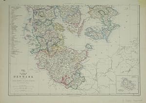
Denmark.
Published by LondonThe Weekly Dispatch. March 4th & 18th 1863, 1860
Seller: Robert Frew Ltd. ABA ILAB, London, United Kingdom
Association Member: ABA ILAB PBFA
Seller rating 5 out of 5 stars
Map
US$ 34.25
US$ 13.30 shipping
Ships from United Kingdom to U.S.A.Quantity: 1 available
Add to basketEach section c. 30 x 42.5 cm. Original outline colour. Lithograph map printed over two sheets (not joined). Publisher's date stamps to margins. Blank on versos. Very good condition.
-
Shropshire.
Published by LondonThe Weekly Dispatch. July10th and November 15th 1863, 1859
Seller: Robert Frew Ltd. ABA ILAB, London, United Kingdom
Association Member: ABA ILAB PBFA
Seller rating 5 out of 5 stars
Map
US$ 34.25
US$ 13.30 shipping
Ships from United Kingdom to U.S.A.Quantity: 1 available
Add to basketEach section c. 30 x 42.5 cm. Original outline colour. Lithograph map printed over two sheets (not joined). Publisher's date stamps to margins. Publisher's descriptionspasted onto verso of southern map sheet. Very lightly browned overall, else in very good condition.
-

Huntingdonshire.
Published by LondonThe Weekly Dispatch. Feby 20th 1863, 1859
Seller: Robert Frew Ltd. ABA ILAB, London, United Kingdom
Association Member: ABA ILAB PBFA
Seller rating 5 out of 5 stars
Map
US$ 34.25
US$ 13.30 shipping
Ships from United Kingdom to U.S.A.Quantity: 1 available
Add to basket30.6 x 42.2 cm. Original outline colour. Lithograph map. Publisher's date stamp to upper left corner. Very good condition.
-
![Seller image for Northamptonshire, (Northern Division) [with] (Southern Division). for sale by Robert Frew Ltd. ABA ILAB](https://pictures.abebooks.com/inventory/md/md17237129066.jpg)
Northamptonshire, (Northern Division) [with] (Southern Division).
Published by LondonThe Weekly Dispatch. May 8th and June 19th 1863, 1859
Seller: Robert Frew Ltd. ABA ILAB, London, United Kingdom
Association Member: ABA ILAB PBFA
Seller rating 5 out of 5 stars
Map
US$ 34.25
US$ 13.30 shipping
Ships from United Kingdom to U.S.A.Quantity: 1 available
Add to basket31.2 x 43.4 cm and 43.2 x 31.1 cm. Original outline colour. Lithograph maps of north and south Northamptonshire. Publisher's date stamps to margins. Publisher's map descriptions pasted onto verso. Very good condition.
-
GREAT NORTHERN RAILWAY, Sheet 1, London to Grantham & Nottingham - an Original Antique Map, 1860
Language: English
Published by Weekly Dispatch, London, 1860
Seller: K Books Ltd ABA ILAB, York, YORKS, United Kingdom
Association Member: ABA ILAB PBFA
Seller rating 5 out of 5 stars
US$ 54.80
US$ 25.93 shipping
Ships from United Kingdom to U.S.A.Quantity: 1 available
Add to basketNo Binding. Condition: Very Good. Edward WELLER (illustrator). An original antique map, mounted (matted) and ready to frame. No date of publication but c1860. The route of the Great Northern Railway is shown in 4 strips arranged side-by-side with counties coloured in outline. Other railway routes are shown as they join the Great Northern. Some fraying to corners, otherwise good.
-
United States of North America (North Central Sheet)
Language: English
Published by The Weekly Dispatch
Map
No Binding. Condition: Good. United States of North America (North Central Sheet). T. Ettling. c. 1855. The Weekly Dispatch. *** A engraved lithograph map with original outline hand coloring. Depicted are western Ohio west to Iowa, and central Missouri north to the Canadian border. Minnesota is still a territory. Lots of interesting details including well established roads and railroad networks. The northern halves of Michigan, Wisconsin, and Minnesota are mostly un populated. *** Clear, clean image with good color, blank verso. Three creases in upper right corner reinforced on verso with archival tape. Close-cropped vertical margins, as issued. Slight ripple along right margin. Sheet is 19 inches high by 13.25 inches, image is 17.25 inches high by 12.5 inches.
-
United States of North America (Eastern & Central)
Language: English
Published by The Weekly Dispatch
Map
No Binding. Condition: Good. United States of North America (Eastern & Central). T. Ettling. c. 1855. The Weekly Dispatch. *** An engraved lithograph map with original outline hand coloring. Depicted are the East Coast states from North Carolina to Florida. The Everglades Swamp is noted as having islands and alligators. Lots of interesting details, including early roads and railroads. Also on this map are most of the Bahama Islands. *** Clean, clear image with good color, some light age toning in margins. Blank verso. A diagonal crease in the upper right corner reinforced on verso with clear archival tape. Slight ripple along right margin. *** Sheet is 19 inches high by 13 inches, image is 17.25 inches high by 11.75 inches.
-

South America: Chile, Paraguay, Uruguay etc., Hand-Coloured Map (1863)
Published by Weekly Dispatch Atlas, UK, 1863
US$ 41.03
US$ 29.19 shipping
Ships from United Kingdom to U.S.A.Quantity: 1 available
Add to basketSoftcover. Condition: Very Good. 1863. A generally very well-presented map, with some minor rubbing and wear along the top edge, neatly trimmed to prevent any major wear. Otherwise no significant creases and only minimal spots, the print itself remains clean and clear with tasteful hand-colouring to highlight borders and boundaries. Why on Amazon do most sellers not describe their actual book? Buy with confidence and support a genuine Independent Bricks & Mortar Real Bookshop. We are Maynard & Bradley CAMBO & PBFA(now lapsed) members here in Leicester City Centre. Size: 445 x 320 mm. 1. Item Type: Book. Quantity Available: 1. Shipped Weight: Under 500 grams. Category: Geography & Maps; Britain/UK; 19th century; Inventory No: 46445.
-
MAP - BELGIUM AND THE DUCHY OF LUXEMBURG
Published by Weekly Dispatch Atlas, London, 1865
Seller: Luis Porretta Fine Arts, Nanaimo RPO Country Club, BC, Canada
Seller rating 3 out of 5 stars

Map
Map. Condition: Very Good. Dust Jacket Condition: No Dust Jacket. This impressive map was published for the SDUK in 1865 and is in very good condition, original outline color, fine detail, edges a little fragile. Images available.; 13" x 19".
-

British, Dutch, & French Guyana, Hand-Coloured Map (1863)
Published by Weekly Dispatch Atlas, UK, 1863
US$ 41.03
US$ 29.19 shipping
Ships from United Kingdom to U.S.A.Quantity: 1 available
Add to basketSoftcover. Condition: Very Good. 1863. A generally very well-presented map, with some spotting and browning along the bottom edge along with a couple of small nicks, repaired with conservation tape to prevent any major wear. Otherwise no significant creases and only minimal spots, the print itself remains clean and clear with tasteful hand-colouring to highlight borders and boundaries. Why on Amazon do most sellers not describe their actual book? Buy with confidence and support a genuine Independent Bricks & Mortar Real Bookshop. We are Maynard & Bradley CAMBO & PBFA(now lapsed) members here in Leicester City Centre. Size: 445 x 320 mm. 1. Item Type: Book. Quantity Available: 1. Shipped Weight: Under 500 grams. Category: Geography & Maps; Britain/UK; 19th century; Inventory No: 46443.
-

US$ 45.14
US$ 29.19 shipping
Ships from United Kingdom to U.S.A.Quantity: 1 available
Add to basketSoftcover. Condition: Good. 1863. A lightly used map, with a few light but visible diagonal creases towards the right-hand side of the image, and the lower-left corner of the page neatly patched and repaired with conservation tape. The image otherwise remains clear and well-presented, with some tasteful hand-colouring to highlight borders and boundaries, overall a good impression. Why on Amazon do most sellers not describe their actual book? Buy with confidence and support a genuine Independent Bricks & Mortar Real Bookshop. We are Maynard & Bradley CAMBO & PBFA(now lapsed) members here in Leicester City Centre. Size: 445 x 320 mm. 1. Item Type: Book. Quantity Available: 1. Shipped Weight: Under 500 grams. Category: Geography & Maps; Britain/UK; 19th century; Inventory No: 46444.