Order Total (1 Item Items):
Shipping Destination:

Africae Tabula Nova (36 results)
Skip to main search results
Search filters
Product Type
- All Product Types
- Books (8)
- Magazines & Periodicals (No further results match this refinement)
- Comics (No further results match this refinement)
- Sheet Music (No further results match this refinement)
- Art, Prints & Posters (10)
- Photographs (No further results match this refinement)
- Maps (18)
- Manuscripts & Paper Collectibles (No further results match this refinement)
Condition Learn more
- New (No further results match this refinement)
- As New, Fine or Near Fine (1)
- Very Good or Good (10)
- Fair or Poor (No further results match this refinement)
- As Described (25)
Binding
- All Bindings
- Hardcover (No further results match this refinement)
- Softcover (No further results match this refinement)
Collectible Attributes
- First Edition (2)
- Signed (No further results match this refinement)
- Dust Jacket (No further results match this refinement)
- Seller-Supplied Images (32)
- Not Print on Demand (36)
Language (4)
Free Shipping
Seller Location
Seller Rating
-

Condition: Ottimo. Grande litografia stampata su carta speciale Estratta da una ristampa anastatica del 1992 Incisione del XVI secolo raffigurante l'Africae Tabula Nova, la carta dell'Africa di Abraham Ortelius, tratta dal Theatrum Orbis Terrarum pubblicato ad Anversa nel 1595. La mappa, incisa da Frans Hogenberg, deriva in gran parte dalla grande carta murale di Giacomo Gastaldi del 1564 e dalle opere di Paolo Forlani e Gerardus Mercator, ma Ortelius la rielabora con maggiore precisione, correggendo la forma del Capo di Buona Speranza, riducendo l'estensione orientale del continente e migliorando la rappresentazione del Nord Africa. La carta include numerosi toponimi ancora oggi riconoscibili, come Mozambico e Benin, e riflette le conoscenze acquisite grazie alle esplorazioni portoghesi e spagnole del XV e XVI secolo. Le coste sono arricchite da navi e mostri marini, mentre i cartigli ornamentali e le iscrizioni latine sottolineano la fusione tra scienza e arte tipica della cartografia rinascimentale. Ortelius, nato ad Anversa nel 1527, fu il primo cartografo a raccogliere e uniformare in un'unica opera le migliori carte disponibili, creando un atlante che offriva al lettore una visione sistematica e coerente del mondo conosciuto. Il Theatrum Orbis Terrarum, stampato per la prima volta nel 1570 dall'editore Gilles Coppens de Diest e successivamente ampliato e ripubblicato fino agli inizi del XVII secolo, � considerato il primo atlante moderno perch� per la prima volta le carte furono raccolte in un formato uniforme, corredate da testi esplicativi e organizzate in un corpus coerente. L'opera ebbe un successo straordinario, con oltre quaranta edizioni in diverse lingue, e divenne uno strumento fondamentale per studiosi, mercanti e viaggiatori dell'Europa moderna. Questa tavola, con la sua capacit� di illustrare l'Africa secondo la visione geografica del tardo Rinascimento, � quindi non solo un documento cartografico di grande interesse ma anche una testimonianza diretta della rivoluzione culturale e scientifica che port� alla nascita della cartografia moderna, ideale per collezionisti, studiosi e bibliofili. Dimensioni: Cm 57,00 x 44,00 Codice prodotto: Litografie - 2696 PayPal Carta di credito Bonifico bancario Inserita dentro plico di adeguate dimensioni per proteggerne l'integrit� Spedizione con posta ordinaria o raccomandata scelta dall'Acquirente nel momento del pagamento Clicca qui per accedere al nostro Store ed al suo sterminato archivio Litografie - 2696.
-
Africae tabula nova
Published by Anversa, 1588
Seller: libreria antiquaria perini Sas di Perini, Verona, VR, Italy
Seller rating 5 out of 5 stars

Art / Print / Poster
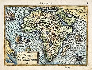
Incisione in rame, fascinosa coloritura posteriore, mm 80x110. Piacevole carta in miniatura tratta da �Epitome du Theatre du monde� una edizione tascabile del �Theatrum Orbis Terrarum� il primo atlante moderno, comprendente carte di tutte le zone del mondo; la geniale intuizione di Ortels, latinizzato successivamente in Ortelius, fu appunto questa: prima d�allora la produzione cartografica era stata irregolare, locale a livello di produzione ed i pochi atlanti, i cosiddetti �Atlanti Lafreriani� erano costituiti su richiesta raccogliendo solo carte di alcune zone. Ortelius riun� in un unico corpus la produzione cartografica eterogenea del periodo, costituendo la base per un�impresa editoriale di enorme successo, pubblicata tra il 1570 e il 1612. Buon esemplare stampato piuttosto decentrato in alto nel foglio, nota manoscritta nel margine inferiore, tracce di sporco superficiali e qualche macchia Nr.cat: cod 5800.
-

Africae Nova Tabula
Language: Dutch
Published by Henricus Hondius II (1597 - 1651), Amsterdam, 1631
Seller: Antique Print & Map Room, Ultimo, NSW, Australia
Association Member: ANZAAB ILAB
Seller rating 5 out of 5 stars
Map
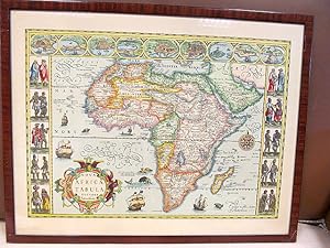
No Binding. Condition: Very Good. Very decorative c.17th map of Africa. Jodocus Hondius removed the surrounding panels of figures on Henricus Hondius's earlier map to enable the map to be included in folio atlases. In 1604 he had purchased the plates of Mercator's Atlas from Mercator's grandson. Hondius republished Mercator's work with 36 additional maps, including several which he himself had produced. The maps have since become known as the 'Mercator-Hondius'series. After his death in 1611, his publishing work in Amsterdam was continued by his widow and two sons, Jodocus II and Henricus. This is the third state of five. The title cartouche has an animal head at top surrounded by a wreath. There are six galleons in full sail and sea monsters and flying fish in the seas. Neptune and mermaid are depicted reiding a wave at lower left. Numerous animals are shown on the map, including; elephants, lions, monkeys, ostriches and goats. Technique: Hand coloured copper engraving. Condition: In good condition, with centre fold as issued. Image size: (H) 14.9" x (W) 19.7" Paper size: (H) 19.4" x (W) 22.8".
-

Nova Africae Tabula Auctore Jodoco Hondio
Published by Artist: Hondius Hendrik ( - 1650 ) Amsterdam ca : 1619, 1597
Seller: Antique Sommer& Sapunaru KG, M�nchen, Germany
Seller rating 4 out of 5 stars

Technic: Copper print, colorit: original colored, condition: Some restorations due to original color, mounted., size (in cm): 37 x 50, Map shows total Africa with its countries and borders, decorative offshore ships, sea monsters and animals.
-

Africae Tabula Nova.
Published by Antwerp, 1570-, Latin text edition. 375 x 505mm (14� x 20 inches)., 1573
Seller: Tooley, Adams & Co., Wallingford, OXON, United Kingdom
Seller rating 3 out of 5 stars

US$ 2,270.82
US$ 49.64 shipping
Ships from United Kingdom to U.S.A.Quantity: 1 available
Add to basketPossibly original colour; light soiling to margins, overall a very good example. This beautiful map although derivative is nevertheless one of the cornerstones of any African map collection. (Tooley). Geographically a close copy of Gastaldi's map of 1564, Ortelius adding only one new name Cayneca and making his Cape more pointed. Zanzibar is now on the West Coast and the Nile is based on Ptolemy. It is difficult to date this map precisely, van den Broecke indicates that the number 4 on the verso and the Latin text appears first in 1570, there are a further six editions with Latin text until 1603, when the date under the title is removed. This example has the date 1570. TOOLEY: Africa p.88, illus. NORWICH: 10; VAN DEN BROECKE: 8.
-

Africae Tabula Nova.
Published by Antwerp, 1570-1603, Latin text edition. 375 x 505mm (14� x 20 inches)., 1602
Seller: Tooley, Adams & Co., Wallingford, OXON, United Kingdom
Seller rating 3 out of 5 stars
US$ 1,926.76
US$ 49.64 shipping
Ships from United Kingdom to U.S.A.Quantity: 1 available
Add to basketUncoloured; small hole in the lower margin, expertly repaired and hardly noticeable, otherwise a superb example. This beautiful map although derivative is nevertheless one of the cornerstones of any African map collection. (Tooley). Geographically a close copy of Gastaldi's map of 1564, Ortelius adding only one new name Cayneca and making his Cape more pointed. Zanzibar is now on the West Coast and the Nile is based on Ptolemy. It is difficult to date this map precisely, van den Broecke indicates that the number 4 on the verso and the Latin text appears first in 1570, there are a further six editions with Latin text until 1603, when the date under the title is removed. This example still has the date 1570, but the copperplate has cracked in the title, indicating 1602. TOOLEY: Africa p.88, illus. NORWICH: 10; VAN DEN BROECKE: 8.
-

Africae Tabula Nova.
Published by Antwerp, 1570-, Latin text edition. 375 x 505mm (14� x 20 inches)., 1573
Seller: Tooley, Adams & Co., Wallingford, OXON, United Kingdom
Seller rating 3 out of 5 stars
US$ 2,339.63
US$ 49.64 shipping
Ships from United Kingdom to U.S.A.Quantity: 1 available
Add to basketOriginal colour; light soiling to margins, very short split to the lower margin at centrefold, otherwise a superb example. This beautiful map although derivative is nevertheless one of the cornerstones of any African map collection. (Tooley). Geographically a close copy of Gastaldi's map of 1564, Ortelius adding only one new name Cayneca and making his Cape more pointed. Zanzibar is now on the West Coast and the Nile is based on Ptolemy. It is difficult to date this map precisely, van den Broecke indicates that the number 4 on the verso and the Latin text appears first in 1570, there are a further six editions with Latin text until 1603, when the date under the title is removed. This example has the date 1570. TOOLEY: Africa p.88, illus. NORWICH: 10; VAN DEN BROECKE: 8.
-

Tabula nova partis Africae.
Published by Vienne, 1522
Seller: libreria antiquaria perini Sas di Perini, Verona, VR, Italy
Seller rating 5 out of 5 stars
Art / Print / Poster
Silografia, mm 400x280, colorata. Tratta da "Claudii Ptolemaei Alexandrini geographicae enarrationis libri octo" edizione della "Geographia" di Tolomeo curata da Michael Servetus detto Villanovanus, basata su quella del 1522 di Laurent Fries che a sua volta replica la celebre edizione di Waldseemueller del 1513, le cui carte sono qui ridotte. Le carte geografiche del 1522 di Fries, furono ristampate identiche in tutte le edizioni, con per� notevoli variazioni al titolo, al testo laterale ad al verso. Originariamente scritta attorno al 150 dopo Cristo, la Geographia di Tolomeo, chiamato "Padre della Geografia", pose i principi fondamentali della geografia scientifica; riscoperta nel periodo rinascimentale ed introdotta in ambito europeo, tradotta in latino dal greco, l'opera rappresent� per secoli la pietra miliare della cartografia. Ottimo esemplare, con leggere tracce di sporco superficiale alla piega centrale. Nr.cat: P5110017.
-

Africae Tabula Nova.
Published by Antwerp, Belgium, 1570
Seller: Alexandre Antique Prints, Maps & Books, Toronto, ON, Canada
Seller rating 4 out of 5 stars
Map
Condition: Very Good, age toning. Map of Africa Continent by Abraham Ortelius, published in Theatrum Orbis Terrarum, Latin Text on verso., Size : 367x495 (mm), 14.45x19.49 (Inches), Original Hand Coloring, 0.
-
Africae Tabula Nova.
Published by Antwerp, Belgium, 1570
Seller: Alexandre Antique Prints, Maps & Books, Toronto, ON, Canada
Seller rating 4 out of 5 stars
Map
Condition: Very Good, age toning. Map of Africa Continent by Abraham Ortelius, published in Theatrum Orbis Terrarum,Latin Text on verso., Size : 378x507 (mm), 14.88x19.96 (Inches), Original Hand Coloring, 0.
-
![Seller image for AFRICAE Nova Tabula [Africa] for sale by Frame](https://pictures.abebooks.com/inventory/md/md31239910359.jpg)
Condition: ACEPTABLE. [Un] Mapa, correspondiente a la primera estampaci�n en blanco y negrode la edici�n de 1636 de los mapas de Mercator-Hondius editados para el Novus Atlas de Janssonius. Edici�n con el texto en lat�n al dorso. Johannes Janssonius (tambi�n conocido como Johann, o Jan Jansson, o Janszoon), naci� en Arnhem en 1588 y falleci� en Amsterdam en1664. Hijo de Jan Janssen, fue un renombrado ge�grafo y editor del siglo XVII, en el contexto en que los holandeses dominaban la publicaci�n de mapas en Europa. Jan conoci� el oficio por primera vez a trav�s de su padre, quien tambi�n era librero y editor. En 1612, se cas� con Elisabeth Hondius, hija de Jodocus Hondius y hermana de Henricus. Tras su matrimonio, se instalaron en Amsterdam, donde �l ejercer�a como librero y editor de material cartogr�fico. Curiosamente, se instal� junto a la librer�a Blaeu, yas� estall� la encarnizada competencia entre Jan Janssonius yWillem Jansz Blaeu (1571-1638). En la d�cada de 1630, Janssonius trabaj� con su cu�ado, Henricus Hondius (1597-1651), hijo de Jodocus. Su obra m�s exitosa fue la reedici�n del atlas "Mercator-Hondius". Jodocus hab�a adquirido las planchas del atlas de Mercator, publicado por primera vez en 1595, y agreg� 36 mapas adicionales. Los primeros mapas de Jonssonius datan de 1616. Tras la muerte de Jodocus Hondius, el mismo a�o que Janssonius se cas� con su hija(1612), Henricus se hizo cargo de la publicaci�n y en 1633 Janssonius se uni� a la empresa y comenzaron a publicar atlas juntos, hasta 1640, a�o en que Henricus dej� el negocio enteramente a Janssonius. Su gran atlas pasar�a a llamarse ahora Atlas Novus, y lleg� a constar de 6 vol�menes;y m�s tarde, dada la rivalidad con Joan Blaeu, hijo y sucesor de Willem, volver�a a ampliarloy a editarlo con el t�tulo deAtlas Major y en once vol�menes. Las planchas de cobre de los atlas de Janssonius se vendieron posteriormente a Schenk y Valck. ___________ First State and edition of this map printed in Black and whitefor the Mercator-Hondius Novus Atlas in 1636 with latin text. Formato (cm): 51 aprox.x53.
-
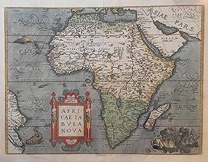
No binding. Condition: Very good. First. Antwerp: [N.p.], 1570 or later. Double-page map of AFRICA (FIRST STATE) from the Latin edition of Abraham ORTELIUS' "THEATRUM ORBIS TERRARUM" (17 � x 21 � inches; 14 � x 19 � inches plate size) with original hand color and full margins. Condition: very good; some creasing in top half along the margins and extending into the image; repair in top right quadrant. LAVISHLY colored map of Africa (including a naval battle scene) based on the cartographical information of Gastaldi's 8-sheet map from 1564 and to a lesser extent the Mercator world map from 1569. Norwich (1983) finds that the "Theatrum Orbis Terrarum" added one name, Carneca, to Gastaldi's Africa, and made the Cape more pointed. Zanzibar is transferred from the east to the west coast. The Nile is based on the Ptolemaic concept. The present map counts as a prototypical representation of Africa in 16th century cartography.
-

Africae tabula nova
Published by Anversa, Jean Baptiste Vrients, 1603
Seller: Libreria Ex Libris ALAI-ILAB/LILA member, Roma, RM, Italy
Seller rating 5 out of 5 stars
Map
Incisione originale su rame (cm. 50,5x37,5 pi� ampi margini) tratta dal 'Theatrum Orbis Terrarum'. Splendida coloritura antica all'acquarello. Margini bianchi laterali con mancanze, altrimenti ottimo esemplare. Provenienza: Biblioteca del Castello di Cirey. Van den Broecke, 8.
-

Africae nova Tabula. Auct. Hen. Hondio. 1631.
Published by Hondius, 1631
Seller: Angelika C. J. Friebe Ltd. - MapWoman, Dorking, United Kingdom
Seller rating 5 out of 5 stars
Map
US$ 1,513.88
US$ 26.72 shipping
Ships from United Kingdom to U.S.A.Quantity: 1 available
Add to basketNo Binding. Condition: Very Good. Hondius Amsterdam 1633 copper engraved map ; overall 48 x 58 cm; plate 38 x 49 cm. Fold as issued; one vertical soft fold; paper evenly toned; small worm holes; some marginal dusting; o/w vg cond. A very decorative map of the African continent by Jodocus Hondius for Mercator's 'Atlas sive Geographicae'. The map is decorated with an elaborate title cartouche and various sailing ships and sea monsters. French text on verso. Pagination 621/624. Hondius intended this map to be part of the first edition Mercator's atlas; unfortunately, the project didn't get finished until 1606, 12 years after Mercator's death, with many edition in Latin, French, Dutch and English. After Hondius' death in 1612, the atlas continued to be published under his name but by his widow until 1619, after which it was republished by his second son, Henricus. [ref: 3382].
-

Regnorum Siciliae et Sardiniae nec non Melitae sen Maltae, Insula cum adjectis Italiae et Africae Litoribus Nova Tabula. Auctore. Ioh. Bapt: Homanno Geogra Norimbergae. Homann, Johann Sardinia Copper Engraving, Hand Colored Grosser Atlas, Nuremberg 1720
Published by Homann 1720-30, N�rnberg, 1720
Seller: Antiquariat Reinhold Berg eK Inh. R.Berg, Regensburg, Germany
Seller rating 5 out of 5 stars
Map
Other. Original antique hand-colored copper engraving, from the Homann atlas, published in Nuremberg, 1720. Depicting Sardinia, this map is a fine example of 1720s European cartography. Image: 488 by 578mm (19 by 22 inches). An attractive and historically significant 18th-century map for the discerning collector. Johann Baptist Homann (16641724) was the most important German cartographer and publisher of the early 18th century. Born in Bavaria, he founded his cartographic publishing house in Nuremberg in 1702, which rapidly became the leading German map publisher. In 1715, Emperor Charles VI appointed him Imperial Geographer (Kayserlicher Geographus), the highest cartographic honor in the Holy Roman Empire. Homann's maps are known for their superb copper engraving, rich hand coloring, and elaborate allegorical cartouches featuring figures, coats of arms, and historical vignettes. After his death in 1724, the firm continued as 'Homann Erben' (Homann's Heirs) and published maps well into the 19th century. Homann maps are held at the Germanisches Nationalmuseum in Nuremberg and major international institutions.A very decorative map of Sicily and Sardinia. With many engraved place-names, rivers. In the upper middle is a allegoric figurative cartouche. Inside the map are a lot of Isles pictured. On the map are same ships to see. At the left lower side is a small picture which shows the region from the famous Vulcan Aetna.A fine example from Grosser Atlas, Nuremberg, sought after by collectors of antique maps of Italy, antique maps of Sardinia, and antique hand-colored copper engravings for sale. In very good condition. Light age-toning to the sheet, as expected for a 18th-century map. In excellent condition. 488 by 578mm (19 by 22 inches). 488 by 578mm (19 by 22 inches).
-
Africae Tabula Nova
Published by Ortelius, Abraham, Antwerp, 1570
Seller: Antikvariat Krenek, Prag, Czech Republic
Association Member: ILAB
Seller rating 5 out of 5 stars
US$ 1,188.21
US$ 16.73 shipping
Ships from Czech Republic to U.S.A.Quantity: 1 available
Add to basketAfrica. "Africae Tabula Nova". Orig. copperplate engraving. A. Ortelius, Antwerp, 1570. With ornamental title-cartouche, 3 sea-monsters and a depiction of a naval battle. 37,5:50 cm (14 3/4 x 19 3/4 inch.). Norwich 10; V. d. Broecke 8.1; Koeman III, map 8600:31, Lat. ed. - First state with the date. - This fine early image of the African continent is based on the Gastaldi wall map of 1564. Published in a Latin edition of Ortelius's ground-breaking atlas Theatrum Orbis Terrarum, it is embellished with a ferocious sea battle southeast of Madagascar and several sea monsters in the Atlantic. The drawing of the far eastern coast of Brazil, shown as well below the Equator, differs significantly from the World and America maps.
-
Africae nova tabula.
Published by Amsterdam,, 1650
Seller: libreria antiquaria perini Sas di Perini, Verona, VR, Italy
Seller rating 5 out of 5 stars
Art / Print / Poster
Copper engraving, original colour, mm 380x500. From "Novus Atlas" Latin edition. Some paper discoloration. Van der Krogt 1; Betz, 58.5 Nr.cat: P2121232.
-
Tabula Nova Partis Africae
Published by Vienna, 1541
Seller: Antipodean Books, Maps & Prints, ABAA, Garrison, NY, U.S.A.
Association Member: ABAA ANZAAB ESA ILAB
Seller rating 3 out of 5 stars
Condition: Very good condition. The second map to show just southern Africa; it is based on the Waldseemuller modern map of southern Africa, and derived from Ptolemy. Decoratively illustrated with African kings, serpents, an elephant and a Christian soldier riding a sea monster towards Madagascar. Three large rivers arise from a mountain range, labeled 'Fontes Nili' (source of the Nile), other mountain ranges, and coastal towns named in Latin or Portuguese. With the figure of the King of Portugal riding a sea monster towards Madagascar. Based on the slightly larger map from 1513 published in "Ptolemy's Geographia". The atlas was reprinted in 1520, 1522, 1525, 1535 and 1541. This wood block was cut in 1525 for the publisher J.Gr�nninger. This being the variant of 1541, now without the banner title, but title in letter type and blank verso. From the last edition of Ptolemy's "Geography", with maps by Laurens Fries and the text edited by Michael Servetus. Servetus was accused of heresy and burnt at the stake. Calvin ordered that copies of the book should be burnt with him, although this copy seems to have eluded the flames. Wood block map with early hand color. Blank on the verso, with the number 39 at the lower right corner. Image size: 16 7/8 x 13". Paper size: 21 1/4 x 15". Strengthened on the verso, very faint browning at middle of center fold, otherwise very good. Betz, p. 55-56. Tooley, "Map Collectors' Circle, No. 30 Printed Maps of the Continent of Africa Part II", p. 61-62. Karrow, "Mapmakers of the Sixteenth Century".
-
Africae nova tabula.
Published by Amsterdam,, 1641
Seller: libreria antiquaria perini Sas di Perini, Verona, VR, Italy
Seller rating 5 out of 5 stars
Art / Print / Poster
Incisione in rame, splendida coloritura d'epoca, mm 380x500. Tratto da "Gerardi Mercatori et I. Hondii atlas". Testo latino al verso. Buon esemplare, su carta uniformemente ingiallita, rinforzo alla giuntura dei fogli, qualche leggera traccia di umidit? ai margini bianchi.
-
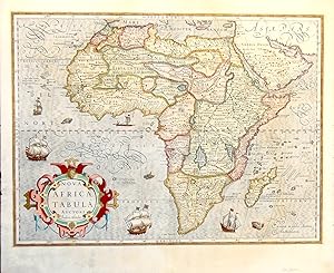
Nova Africae Tabula.
Published by Amsterdam,, 1630
Seller: libreria antiquaria perini Sas di Perini, Verona, VR, Italy
Seller rating 5 out of 5 stars
Art / Print / Poster
Incisione in rame, colorata, 377x505. Affascinante carta del continente arricchita da mostri marini e pesci nell'oceano, animali vari sul continente. Terzo stato su tre, senza la bordura ornamentale. Tratta da "Atlas Maioris appendix" di Hondius, pubblicato nel 1606 per la prima volta dopo l'acquisto, da parte del costruttore di globi Hondius, delle lastre di Mercatore con l'aggiunta di lastre originali di propria creazione. Buon esemplare ben conservato, professionalmente rinfrescato. Nr.cat: 100_5274.
-

Africae Tabula Nova.
Language: Latin
Published by Abraham Ortelius (1527 - 1598), 1598
Seller: Antique Print & Map Room, Ultimo, NSW, Australia
Association Member: ANZAAB ILAB
Seller rating 5 out of 5 stars
Map
No Binding. Condition: Very Good. Famous c.16th map of Africa by Abraham Ortelius from his ground breaking atlas, Theatrum Orbis Terrarum, which was widely regarded as the first modern atlas for having all the maps in a similar size and format. Ortelius was also the first to separate the ancient and recent geographic knowledge when compiling his maps and indicating the changes from the old nomeclature to the new. Unlike many of his contemporaries Ortelius often listed the sources of his information. The engraving of all the copper plates was done by Frans Hogenberg (1539-1590). The map is superbly decorated with an elaborate strapwork title incorporating a pair of caryatids, at the top of which a panel has the words, The Greeks call Africa Lybia, and the seas have various marine life and a raging sea battle in the lower right corner. Ortelius based this map on three maps by the most important cartographers of the sixteenth century: Gastaldi' 1564 separately-issued eight-sheet map, Forlani' 1566 map and Mercator' 1569 world map. Many of the names of coastal towns and other landmarks featured on Gastaldi' map are Portuguese and Arab, reflecting their dominant position in the Indian Ocean in the sixteenth century. The Portuguese had dispelled Ptolemy' concept of a landlocked Indian Ocean by sailing round the Cape in 1497. This allowed them to sail onto India via the African east coast, effectively bypassing the Arab-controlled spice route of the Red Sea, thereby altering the international balance of power. While early maps depicted a fairly accurate African coastline, most of inner Africa would remain unexplored until the nineteenth century. As a result, early maps of Africa were often influenced by myth and other fanciful concepts, leading Jonathan Swift to state ' geographers, in Africa maps, With savage pictures fill their gaps, And o' uninhabitable downs Place elephants for want of towns'. This map remained the standard map of the continent for the remainder of the sixteenth century. This edition is identified as being from the 1575 Latin edition, by the following: Latin text on the verso, small page number 4 (7 mm), similar, 9th text line from the top ends: Atlanticum ver ; last line, centred like 4 lines above it: Rhamusij,&Hieronymi Fracastorij. Collections: National Library Australia: Call Number MAP NK 10001 State Library New South Wales: Record Identifier 74Vv8PVPNxMl (1570? shows crack at left which appeared in 1575) Library of Congress Washington D.C.: 2017585795 British Library London: D2018_000051_BL National Maritime Museum Greenwich: ID: PBD7640(1) Technique: Hand coloured copper engraving. Condition: In good condition, with centre fold as issued. Image size: 14.6 x 19.7" Paper size: 17.4" x 22.8".
-

World Map and 4 continents - set of 5 engraved handcolored maps. - "Mappa Totius Mundi vel Planiglobium Terrestris" - "Nova Tabula Americae" - "Nova Tabula Europae" - "Nova Tabula Asiae" - "Nova Tabula Africae"
Language: German
Published by Augsburg, Kilian, 1759
Seller: Antiquariat Steffen V�lkel GmbH, Seubersdorf, Germany
Seller rating 5 out of 5 stars
Art / Print / Poster
each map-size c. 27 x 34,5 cm -- each sheet c. 300 x 370mm -- the map of Africa with marginal tear into image on bottom, not closed and no loss. -- light age toning -- a very rare and decorative set. -- On the world map and the America map California is shown as an island. // Wir, das Antiquariat Steffen V�lkel, kaufen und verkaufen alte B�cher, Handschriften, Zeichnungen, Autographen, Grafiken und Fotografien. Wir sind stets am Ankauf von kompletten Bibliotheken, Sammlungen und Nachl�ssen interessiert. Sprache: Deutsch Gewicht in Gramm: 550.
-
Africae nova tabula Auct. J. Hondio New map of Africa designed by J Hondius
Publication Date: 1673
Seller: Rare Collections, Brighton East, VIC, Australia
Association Member: ABA
Seller rating 5 out of 5 stars
Jan Evertsz Cloppenburg (Publisher) Pieter vd Keere engraved the map [1630] 1673 Introductio in universam geographiam Amsterdam; Johannes Janssonius van Wesberge, 1673 [1630] This small map (25cm x 18.5cm) was engraved by Pieter van den Keere (AKA Petrus Kaerius) and is in the 1st state. It seems to be based on the 1617 map by Willem Blaeu's 1617 and the Jodocus Hondius II maps of 1619 & 1623; The map was used in a number of publications, originally in Atlas Minor (Mercator / Hondius) - with the number 11 at the top right. The features of no page number, no signature and no print above the map are consistent with its publication in the 1673 Atlas Minor. "The Cloppenburch (i.e. Jan Evertz Clobbenburg) version of the Mercator-Hondius Atlas Minor (i.e. this map) was only published in 1630, 1632, and 1636. Cloppenburch was either forced out of business or Johannes Janssonius bought his copperplates, as the plates later appeared in a 1673 edition of Atlas Minor by Johannes Janssonius van Waesberge, the son-in-law of Janssonius. A second edition of this atlas appeared in 1676 in Dutch and Latin. This map also appeared in 1676 in an edition of Phillip Cl�ver's Introductionis in Universam Geographicam." (Betz's Mapping of Africa # 65) This outline coloured map is in very good condition. There is age-toning (paper oxidation) outside the plate line (especially at the top and on the right) caused by prior mounting non non-archival boards., some chipping to the top edges, Acid free tape strips on the top back from previous mounting. Small 2mm hole of the west coast of Southern Africa between the coast and the illustrated boat 250 by 185mm (9� by 7� inches).
-
Nova Africae Tabula Auctore Jodoco Hondio. Excusum in edubus Auctoris Amsterdammi 1617. ( Nachdruck )
Seller: Antiquariat Friederichsen e. K., Hamburg, Germany
Association Member: BOEV
Seller rating 5 out of 5 stars
Art / Print / Poster
Bildma� der Darstellung ca. 41 x 61 cm ( H�he x Breite ), Rahmenma� ca. 54 x 70 cm ( unge�ffnet ). Der offensichtliche Nachdruck mit zahlreichen kleinen die Karte umgebenden Vignetten mit Figuren und Ortsansichten, auf der Karte eine sch�ne Titelkartusche, eine Windrose, einige Schiffe und Meeresgetier. Das sch�ne Blatt ist im wei�en Au�enrand gebr�unt, und gering fleckig sonst von guter Erhaltung. Der Rahmen ist st�rker besto�en. ( Bitte beachten: Hier ist wegen Bruchgefahr und �bergr��e leider kein Versand m�glich - hier bitte nur Selbstabholung nach Absprache bzw. selbst organisierter Abtransport ). ( Lagerort KG ) ( Weitere Bilder auf Anfrage ) / Artikel 22247 /// Image size approx. 41 x 61 cm (height x width), frame size approx. 54 x 70 cm (unopened). This is an apparent reprint with numerous small vignettes surrounding the map, depicting figures and townscapes. The map itself features a beautiful title cartouche, a compass rose, and several ships and marine animals. The attractive sheet is browned along the white outer edge and slightly stained, otherwise in good condition. The frame shows more significant wear. (Please note: Due to the risk of breakage and its size, shipping is unfortunately not possible collection in person by prior arrangement or self-organized transport is preferred.) (Location: KG) (Further images available upon request) / Item 22247 /// Dimensions de l'image: env. 41 x 61 cm (hauteur x largeur); dimensions du cadre: env. 54 x 70 cm (non ouvert). Il s'agit vraisemblablement d'une r�impression orn�e de nombreuses vignettes repr�sentant des personnages et des paysages urbains. La carte elle-m�me pr�sente un �l�gant cartouche de titre, une rose des vents, ainsi que plusieurs navires et animaux marins. La belle feuille est brunie sur le bord blanc ext�rieur et l�g�rement tach�e, mais reste en bon �tat. Le cadre est plus us�. (Attention: en raison du risque de casse et de ses dimensions, l'exp�dition est malheureusement impossible. Le retrait sur place (sur rendez-vous) ou le transport par vos soins sont pr�f�rables.) (Lieu: KG) (Photos suppl�mentaires disponibles sur demande) / Article 22247.
-

Africae nova Tabula.
Publication Date: 1650
Seller: Geographicus Rare Antique Maps, Brooklyn, NY, U.S.A.
Association Member: ABAA ESA ILAB
Seller rating 4 out of 5 stars
Map
Very good. Upper margin reinforced and recornered, else excellent. Size 14 x 18.5 Inches. This is Peter Mariette's 1650 map of Africa, published in his Theatre G�ographique de France . The present example is a rare French edition that does not appear in OCLC and has appeared only twice on the market since 2008. A Long-Lived and Influential Mapping This map's geography originally appeared in the 1619 Africae nova Tabula of Jodocus Hondius Jr. as part of his set of four continent maps and remained a staple of the Hondius/Janssonius atlases. It was widely copied: Bertius, Tavernier, Boisseau, and Berey all produced works based on this map, as did Mariette. The present map of Africa - though anonymous - is attributed to Peter Mariette, who included it in his 1650 Theatre G�ographique de France . Although published in Paris, the map's geography and decorative elements are Dutch, leading some to believe it to have been engraved by Cornelis Danckerts. A Closer Look The map's cartography follows Hondius' original both in terms of detail and execution. The coastline, in particular, is rich in toponomy, and the overall shape of the continent is accurate. Points within the continent, nonetheless, reveal the European ignorance of Africa's interior that would remain largely unchanged until well into the 19th century. The Nile, for example, is illustrated with its sources in the lakes of Zaire and Zaflan, an assumption inherited from no less venerable an authority than the 2nd-century Alexandrian geographer Claudius Ptolemy. The equally fictitious Lake Sachaf, derived from Laurent Fries' 1522 geography, appears in southern Africa, feeding the Zambere River, which flows to the Rio de Spirito Santo. The Cuama River is shown north of the Rio de Spirito Santo, but unlike earlier maps (including the 1608 Blaeu wall map), the Cuama is given its own source rather than sharing Lake Sachaf. The Niger River is shown running, essentially, in the wrong direction, emptying into the Senegal River after having flowed from a supposed Lake Niger (a misunderstanding of the Niger Inland Delta?) in the general vicinity of what is now the Central African Republic. (The detailed mapping of the Niger River would not be complete until the 1890s.) The map is embellished with lions, zebras, elephants, ostriches, and camels. There is even, south of the Niger River, a dragon. Flying fish skim the waters west of Guinea, and two ships sail the Oceanus Aethiopicus in the lower left quadrant of the map. Publication History and Census Betz attributes the work to Pierre Mariette, who included it in his c. 1650 Theatre G�ographique de France . This map's engraver is unknown, but Betz proposes Cornelis Danckerts, who collaborated with Mariette on the 1647 Totius Africae Nova et Exacta . The map is rare. There are no examples cataloged in OCLC, and it has only appeared on the market twice since 2008. References: Betz, R., The Mapping of Africa #80.
-

Regnorum Siciliae et Sardiniae nec non Melitae, seu Maltae Insuale cum adjectis Italiae, et Africae Litoribus Nova Tabula.
Publication Date: 1710
Seller: Geographicus Rare Antique Maps, Brooklyn, NY, U.S.A.
Association Member: ABAA ESA ILAB
Seller rating 4 out of 5 stars
Map
Very good. Minor soiling to bottom corners. Contemporaneous backing on paper. Minor partial centerfold split, fully stabilized on verso. Size 20.5 x 23.25 Inches. A beautiful example of Johann Baptist Homann's 1710 map of Sicily and Sardinia, Italy. The map illustrates the islands as they were vigorously contended for by the Spanish Hapsburgs and the French Bourbons during the War of Spanish Succession (1701 - 1714). A Closer Look Coverage extends from Sardinia to Calabria and the Gulf of Taranto, south to include all of Sicily, Malta, Gozo, and parts of northern Africa in the vicinity of Tunis. Sicily is divided according to its ancient provinces: Val di Mazara, Val di Noto, and Val Demone. A large inset in the lower left illustrates Catania, with Mout Etna erupting in the background - likely referencing the devastating eruption and earthquake of 1693, which destroyed the city and the surrounding Val di Noto. In the lower right, an inset of Valletta, Malta, reflects its role as the stronghold of the Knights Hospitaller, whose naval defenses provided the first line of defense against Ottoman expansion. The allegorical cartouche at the top center underscores the fertile island's role as a breadbasket of the Mediterranean. Supporting figures hold aloft bunches of great and a cycle - symbols of harvest and plenty. Below, cherubs support the arms of Sicily and Sardinia. Above and to the right of the cartouch, Hephaestus, god of fire, metalworking, and craftsmanship, works his forge, which mythology associates with Mt. Etna. Sicily, Sardinia, and the War of the Spanish Succession During the War of Spanish Succession (1701 - 1714), Sicily and Sardinia played pivotal roles as strategically significant Mediterranean islands vigorously contested by European powers. Initially, under Spanish Habsburg control, these islands became bargaining chips in the broader conflict over the Spanish throne following the death of Charles II of Spain in 1700. The war saw alliances shift as the Bourbon claimant, Philip V of Spain, fought against a coalition of European powers seeking to prevent Bourbon dominance. By the Treaty of Utrecht in 1713, which ended much of the war, Sicily was awarded to Victor Amadeus II of Savoy, marking the Savoyard dynasty's rise as a European power. Sardinia, however, remained with Spain until 1720, when it was ceded to the Austrian Habsburgs in exchange for Sicily as part of the Treaty of The Hague. This exchange established the Kingdom of Sardinia under Savoyard control, with Sardinia remaining a key element of Italian unification in the 19th century. The war reshaped the political landscape of the Mediterranean, reducing Spanish influence and distributing territorial control among emerging European powers. Publication History and Census This is the first plate of this map - engraved between 1707 and 1710 for inclusion in the 1710 edition of the Neuer Atlas . It has a notably richer impression and finer engraving than the subsequent c. 1715 plate, recognizable by less expressive engraving and the inclusion of Homann's Privilege. The present example is from a 1710 edition of the Neuer Atlas . In its many editions, the map is well-represented in institutional collections, and versions of the map occasionally appear on the market. However, there is no complete census of individual states and plates, so the dating of these pieces is difficult to determine without examination of the maps themselves. References: OCLC 694920584.
-

1606 Nova Afric� Tabula Auctore Jodoco Hondio
Seller: New World Cartographic, Chicago, IL, U.S.A.
Seller rating 4 out of 5 stars
Map
By: Jodocus HondiusDate:1606 (Dated) AmsterdamDimensions: 14.8 x 19.7 inches (37.5 cm x 50 cm)This magnificent map shows the African continent as it was known in 1606, including the island of Madagascar and the Arabian Peninsula. Vignettes include four European sailing ships as well as a local launch.Geographical and topographical features are in abundance and cities, towns and villages are named. Three sea monsters, plus a camel, an elephant, and a monkey, and elaborate swirling calligraphy further embellish the map. On the reverse, labeled page 332, is a note to the reader, appearing to say that the section on Europe is concluded and explanations of following regions can be found at the beginning of the text. Underneath is a large fanciful, triangular fleuron, or elaborate ornament ending a section. Map and text in Latin.Condition: Superior condition with centerfold split at top and bottom margin. Centerfold reinforced with archival tape.Inventory #192041200 W. 35th St. #425 Chicago, IL 60609 | P: (312) 496 - 3622.
-

1579 Africae Tabula Nova
Seller: New World Cartographic, Chicago, IL, U.S.A.
Seller rating 4 out of 5 stars
Map
By: Abraham OrteliusDate: 1579 (published) AntwerpDimensions: 14.5 x 18 inches (36.83 x 45.72 cm)This authentic antique map of Africa was published by Abraham Ortellius in 1588. It was taken from Ortelius' Theatrum Orbis Terrarum, the first modern atlas, which was widely produced for over 40 years in 7 different languages.Ortelius' map of Africa is based on Gastaldis 8 sheet wall map and Mercators world map of 1569. Two notable geographic changes Ortelius made to the shape of Africa are a more pointed Cape of Good Hope and an eastern coastline that extends far less than many earlier maps of Africa show. Ortelius was also the first to include sources of the information displayed in his map. Also, while many map makers tend to fill the African continent with vignettes of animals, often in an attempt to mask their geographical ignorance of the area, Ortelius leaves the African continent completely void any such distraction. If an area is blank, it's simply because it's unexplored lands.This map however is not completely absent of decoration. A sea battle is depicted in a cartouche in the lower right hand corner of the map, and a number of sea monsters roam the vast Atlantic Ocean, shown off the western coast of Africa. The title cartouche is classical in design, with two armless statues of women and 4 lions' heads incorporated in the supporters, and is completed with decorative scrollwork.This example of Africae Tabula Nova comes out of the rare Spanish edition of Theatrum Orbis Terrarum. The Spanish edition is the initiative of Christoffel Plantijn himself. After a short stay in Calvinistic Leiden it was necessary for him to prove his loyalty to the Spanish King, so he decided to publish a Spanish translation of the Theatrum, dedicated to the future King Philip III. The Franciscan monk Balthasar Vincentius translated the text on the verso into Spanish.Ref: Norwich, No. 10Condition: This map is in B condition withblight browning and minor separations (reinforced) along the centerfold, light soiling in the margins, and faint damp-staining along the top margin, most notable in the upper left.Inventory #119071200 W. 35th Street #425 Chicago, IL 60609 | P: (312) 496 - 3622.
-

1598 Africae Tabula Nova
Seller: New World Cartographic, Chicago, IL, U.S.A.
Seller rating 4 out of 5 stars
Map First Edition
By: Abraham OrteliusDate: 1570 / 1598 (published) AntwerpDimensions: 14.5 x 18 inches (36.83 x 45.72 cm)This exceptional map of Africa was published by Abraham Ortellius in 1598. It was originally printed in 1570 in the first edition ofTheatrum Orbis Terrarum, Western Europes first modern atlas. The work was widely produced for over forty years, in seven different languages.Ortelius' map of Africa is based on Gastaldis eight sheet wall map and Mercators world map of 1569. Two notable geographic changes Ortelius made to the shape of Africa are a more pointed Cape of Good Hope and an eastern coastline that extends far less to the east than do many earlier maps of Africa. Ortelius was also the first to include sources to the information displayed in his map. Also, while many map makers tend to fill the African continent with vignettes of animals, often in an attempt to mask their geographical ignorance of the area, Ortelius leaves the African continent completely void of any such distraction.The map however, is not completely void ofornamentation. A vignette in the lower right depicts a raging sea battle with ships sails billowing and cannons firing, and a number of sea monstersare roaming the Atlantic off the western coast of Africa. The ornamental title cartouche is classical in design, with two armless statues of women and four lions' heads incorporated in the strap work, all of which is further embellished with decorative scrollwork.This example of Africae Tabula Nova comes out of theFrench edition of Theatrum Orbis Terrarum.The examples published in the late 16th century are identifiable by a vertical crack that developed in the title cartouche area of the copper plate.Ref: Norwich, No. 10Condition: This map isin A condition with a small centerfold separation that has been closed using archival materials on the verso. The map exhibits old color with some later touch-ups as well as some discoloration surrounding the map from prior matting.Inventory #120781200 W. 35th Street #425 Chicago, IL 60609 | P: (312) 496 - 3622.
-

Africae nova Tabula Auct. Hen. Hondio.
Publication Date: 1666
Seller: Geographicus Rare Antique Maps, Brooklyn, NY, U.S.A.
Association Member: ABAA ESA ILAB
Seller rating 4 out of 5 stars
Map
Very good. Mended centerfold split with minor loss to border, not impacting map image. Size 14.75 x 19.75 Inches. This is an attractive example of the Hondius map of Africa. It is a classic of Dutch decorative cartography. The map is embellished with lions, zebras, elephants, ostriches, and monkeys, while the oceans display seven sailing ships menaced by sea monsters. Flying fish skim the waters west of Guinea. A merman and mermaid embrace in the southern Atlantic - a recurring image in Hondius' maps (the identical couple appears in at least one other, Hondius' 1631 map of Italy.) A Long-Lived and Influential Work This map was originally engraved in 1619 by Jodocus Hondius Jr. as part of a set of four continent maps, and would appear in his brother Henricus Hondius' atlases starting in 1631. It replaced the map engraved by the elder Jodocus Hondius in 1606 - the earlier map had been based largely on the work of Gerard Mercator. Hondius' new map was derived from the 1617 Blaeu folio as well as the 1608 Blaeu wall map of Africa, but it was in turn widely copied: Bertius, Tavernier, Boisseau, and Berey all produced work based upon this map. A Closer Look Hondius's cartography follows Blaeu's folio map both in terms of detail and execution: a wise choice emphasizing clarity and sharpness, presenting detail without sacrificing legibility. The coastline, in particular, is rich in toponomy, and the overall shape of the continent is remarkably accurate. Points within the continent, nonetheless, reveal the European ignorance of Africa's interior that would remain largely unchanged until well into the 19th century. The Nile, for example, is illustrated with its sources in the lakes of Zaire and Zaflan, an assumption inherited from no less venerable an authority than the 2nd-century Alexandrian geographer Claudius Ptolemy. The equally fictitious Lake Sachaf, derived from Laurent Fries' 1522 geography, appears in southern Africa, feeding the Zambere River, flowing to the Rio de Spirito Santo. The Cuama River is shown north of the Rio de Spirito Santo, but unlike earlier maps - including the 1608 Blaeu wall map - the Cuama is given its own source, instead of sharing a source at Lake Sachaf. The Niger River is shown running, essentially, in the wrong direction, emptying into the Senegal River, after having flowed from a supposed Lake Niger (a misunderstanding of the Niger inland delta?) in the general vicinity of what is now the Central African Republic. (The detailed mapping of the Niger River would not be complete until the 1890s.) Publication History and Census This is the fifth state of Jodocus and Henricus Hondius' map. It was initially engraved in 1619. From the 1631 third state, it was included in the majority of the Hondius / Janssonius atlases. This particular example appeared in the 1666 edition of the Atlas Contractus . Thirteen examples of the separate map, in various editions but not this one, are cataloged in institutional collections. The 1666 Atlas Contractus is catalogued only in the Sachsische Landesbibliothek, Staatsbibliothek Zu Berlin, and the ULB Sachsen Anhalt Zentrale. References: Betz, R., The Mapping of Africa A Cartobibliography of Printed Maps of the African Continent to 1700, 58.3. Norwich, O. I., Norwich's Maps of Africa: An Illustrated and Annotated Cartobibliography, 34. Van der Krogt, P. C. J., Koeman's Atlantes Neerlandici, (3 Vols), 8600: 1D.4.