Order Total (1 Item Items):
Shipping Destination:

Akyab, Used (19 results)
Title:
akyab
Refine with Advanced Search
Skip to main search results
Search filters
Product Type
- All Product Types
- Books (17)
- Magazines & Periodicals (No further results match this refinement)
- Comics (No further results match this refinement)
- Sheet Music (No further results match this refinement)
- Art, Prints & Posters (1)
- Photographs (1)
- Maps (No further results match this refinement)
- Manuscripts & Paper Collectibles (No further results match this refinement)
Condition Learn more
- New (No further results match this refinement)
- As New, Fine or Near Fine (5)
- Very Good or Good (6)
- Fair or Poor (1)
- As Described (7)
Binding
Collectible Attributes
- First Edition (No further results match this refinement)
- Signed (1)
- Dust Jacket (No further results match this refinement)
- Seller-Supplied Images (13)
- Not Print on Demand (19)
Language (2)
Free Shipping
- Free Shipping to U.S.A. (No further results match this refinement)
Seller Location
Seller Rating
-

Practical Sailing directions and coasting guide, from the Sand heads to Rangoon, Maulmain, Akyab, and vice versa . To which is added sailing directi
Language: English
Published by British Library, Historical Print Editions, 2011
ISBN 10: 1240924038 ISBN 13: 9781240924035
Condition: As New. Unread book in perfect condition.
-

Condition: As New. Unread book in perfect condition.
-

Practical Sailing directions and coasting guide, from the Sand heads to Rangoon, Maulmain, Akyab, and vice versa . To which is added sailing directi
Language: English
Published by British Library, Historical Print Editions, 2011
ISBN 10: 1240924038 ISBN 13: 9781240924035
Seller: GreatBookPricesUK, Woodford Green, United Kingdom
Seller rating 5 out of 5 stars

US$ 22.73
US$ 20.11 shipping
Ships from United Kingdom to U.S.A.Quantity: Over 20 available
Add to basketCondition: As New. Unread book in perfect condition.
-

Practical Sailing Directions and Coasting Guide from the Sand Heads to Rangoon, Maulmain, Akyab, and Vice Versa. to Which Is Added, Directions for the
Seller: GreatBookPricesUK, Woodford Green, United Kingdom
Seller rating 5 out of 5 stars
US$ 43.53
US$ 20.11 shipping
Ships from United Kingdom to U.S.A.Quantity: Over 20 available
Add to basketCondition: As New. Unread book in perfect condition.
-
Practical Sailing Directions and Coasting Guide from the Sand Heads to Rangoon, Maulmain, Akyab, and Vice Versa; with a Table for the Dangerous Gulf of Martaban
Published by C. W. Coard, London, 1859
Seller: curtis paul books, inc., Crestline, CA, U.S.A.
Seller rating 5 out of 5 stars
Hardcover. Condition: Good. Second Edition. Second edition, improved. Original cloth with a Liverpool chronometer maker's label on front pastedown. Lacking front flyleaf. Light wear to boards. Sturdy copy. ; 12mo 7" - 7�" tall.
-
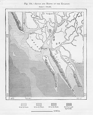
Akyab or Sittwe in the Rakhine State of Myanmar (Burma), 1880s MAP
Published by Reclus
Seller: Artisans-lane Maps & Prints, Sidney, BC, Canada
Seller rating 4 out of 5 stars

Art / Print / Poster
no binding. Condition: very good. It is situated on the northeastern coast of the Bay of Bengal, near the mouth of the Kaladan River. The Kaladan River is an important river in Myanmar that originates in the Chin State and flows through the Rakhine State before reaching the Bay of Bengal. The mouth of the Kaladan River is located near Akyab/Sittwe. Map Size: 5 x 4 1/2 ins . Overall Size including borders : 10 1/2 x 7 Ins . CONDITION: Text and map on the back. Clear and sharp with beautiful detail. As scanned. This map would look great matted and framed. Or an art supply store can provide you with a selection of frames for old art treasures. NOTE THE FOLLOWING BEFORE YOU PURCHASE: This is a GENUINE ANTIQUE VINTAGE 1880s Map. It is NOT a modern reproduction, ie. a laser scan, photocopy etc. It is the original from the antique or vintage atlas or book publication. This print was published on the date mentioned, or circa of the date mentioned at the top of the page. The print I have for sale, like many antique vintage prints and maps that you see online, originate from an antique vintage book or atlas publication. The publication may not always be known. If you have any questions, emails are welcome.
-

Condition: Gut. Zustand: Gut | Sprache: Englisch | Produktart: B�cher | Reprint of the original, first published in 1859.
-
Condition: Hervorragend. Zustand: Hervorragend | Sprache: Englisch | Produktart: B�cher | Reprint of the original, first published in 1859.
-
PRACTICAL SAILING DIRECTIONS AND COASTING GUIDE, FROM THE SAND HEADS TO RANGOON, MAULMAIN, AKYAB, AND VICE VERSA;
Published by London:H. Hughes, 1871
Seller: Parnassus Book Service, Inc, YarmouthPort, MA, U.S.A.
Association Member: SNEAB
Seller rating 5 out of 5 stars
hard cover. Condition: Good. No jacket. 5th or later printing. With A Table for the Dangerous Gulf of Martaban, Sets of Current, and Desciption of the Land.� 6th edition, Enlarged and Improved. To Which is Added Directions for the Entire Bay of Bengal, and Straits of Malacca. London:H. Hughes. 1871. 6th edition. 140pp. Hardcover.� Boards soiled and shelfworn, with sun-fading along spine strip and on front cover. With wear to all edges, including chipping to spine edges and spine ends, and edge points worn to boards. Internally, the binding is tight but both hinges are cracked, with front free end-page missing, and a chip to bottom of edge of first page of testimonials. There are no previous owners signatures, but the back end-pages do have some ciphering to them. With some light age-toning and some spots of foxing scattered throughout.�.
-

Practical Sailing Directions and Coasting Guide From the Sand Heads to Rangoon, Maulmain, Akyab, and Vice Versa : with a Table for the Dangerous Gulf . Sets of Current, and Description of the Land
Published by Printed By C. W. Coard, 1859
Seller: Isaiah Thomas Books & Prints, Inc., Cotuit, MA, U.S.A.
Association Member: ABAA ILAB SNEAB
Seller rating 4 out of 5 stars
Unknown Binding. Condition: Good. Blind stamped brown boards rubbed and edge worn. Some stains to covers. Yellow coated end papers cracked front and back but holding well. Signature of Captain John Freeman, Brewster [MA} on rear end paper. Occasional minor smudge to margins. Lat/long settings for Preparis Island North end ink out on p. 79; 80 pages.
-

Condition: Hervorragend. Zustand: Hervorragend | Sprache: Englisch | Produktart: B�cher | Reprint of the original, first published in 1859.
-
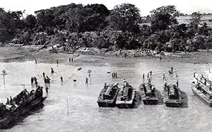
No binding. Vintage news agency photograph, stamped on back. Unusual press print on very thin photo paper. *** Date : 1945 *** Location/Lieu : Burma, Akyab *** Photographer/Credit : NEWS SERVICE (Misc) *** Categories : Burma - WWII, Water Transportation *** Silver print on very thin photo paper, Good condition, light creases *** Size in inches/Taille en pouces (1 inch=2,5 cm) : about 6.12x3.92 - Size in centimeters/Taille en centimetres : about 15.30x9.80.
-
Practical sailing directions and coasting Guide : from the Sand Heads to Rangoon, Maulmain, Akyab, and vice versa, with a table for the dangerous Gulf of Martaban, sets of current, and description of the land
Published by London : H. Hughes, 1871
Seller: Sequitur Books, Boonsboro, MD, U.S.A.
Association Member: IOBA
Seller rating 5 out of 5 stars
Hardcover. Condition: Good. 6th ed., enl. and improved. [Pilot guides - Bay of Bengal] Bound in publisher's cloth. Most of spine cloth detached. 140 pages ; 23 cm. Pages in good condition. Contemporary signature of Ph. Pendleton and another man.
-
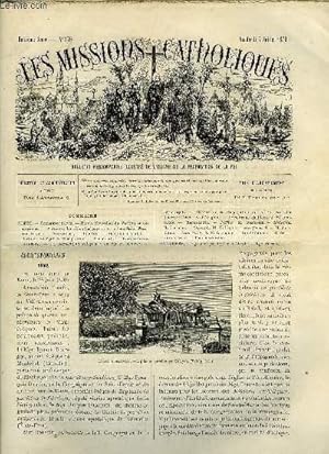
Les missions catholiques n� 370 - Rome, Nouvelles du Vatican et des missions, Le schisme chald�en, Une conversion, Eglise et presbyt�re d'Akyab, Mgr Purcell
Published by Aux bureaux de l'oeuvre de la propagation de la foi, 1876
Couverture souple. Condition: bon. R110532370: 7 juillet 1876. In-12. Broch�. Bon �tat, Couv. convenable, Dos satisfaisant, Int�rieur frais. Pagin� de 313 � 324. Texte en colonnes. Quelques gravures en noir et blanc dans et hors texte. . . . Classification Dewey : 234-La foi.
-

Sailing Directions for the Ports of Akyab, Rangoon, & Bassein presented by Messrs Mohr, Brothers & Co.
Published by New York, Wynkoop. Hallenbeck & Thomas, printers., 1859
Seller: JF Ptak Science Books, Hendersonville, NC, U.S.A.
Seller rating 5 out of 5 stars
Soft cover. Condition: Fair. Sailing Directions for the Ports of Akyab, Rangoon, & Bassein presented by Messrs Mohr, Brothers & Co. New York, Wynkoop. Hallenbeck & Thomas, printers. 1859 (?) 8"x 5.5". 8pp. Original wrappers. Two small rubber stamps on the cover and title page (only abou 10x15mm) and a small (10mm) perforated stamp for the Library of Congress on the bottom of the title page. Also a LC surplus stamp on rear cover (mostly faded away). NO copies in WorldCat. [++] Provenance, the Library of Congress via Caleb Cushing via Margaret W. Cushing. [++] Caleb Cushing was elected to the U.S. Congress in 1834, where he served four terms. In 1843-44 he undertook a mission to China, where he negotiated the Treaty of Wanghia (1844), the first bilateral agreement between the United States and China. He was ambassador to Spain, and was also US Attorney General under Pierce. Margaret W. Cushing gifted Caleb Cushing's papers to the LCthis is one of those items, with a small rubber stamp stating the pamphlet as a gift via Margaret W Cushing.
-

Akyab.
Published by Army Map Service, Corps of Engineers, U.S. Army., Washington, D.C., 1954
Seller: Asia Bookroom ANZAAB/ILAB, Canberra, ACT, Australia
Association Member: ANZAAB ILAB
Seller rating 5 out of 5 stars
Colour map,1:250,000 scale. Transverse Mercator projection. 58.5 x 75.0cm. Chips and few small closed tears mainly at margins, repaired on reverse with Japanese acid-free tissue, length of cellotape runs vertically between top and bottom edges on right-hand edge of map, marked in few other places, little browned where it has been folded, still a useful copy of a highly interesting region. Series U542, Sheet NF 46-14, Edition 1 - AMS. Printed for D Survey, Ministry of Defence, United Kingdom by Ordnance Survey. A very detailed topographic map centred on the Union of Burma-East Bengal border and Akyab/Sittwe, the capital of modern-day Rakhine State, formerly Arakan.
-
Ordnance Maps. Sheet No. 84. Laid on cloth.
-

Practical Sailing Directions and Coasting Guide, From the Sandheads to Rangoon, Maulmain, Akyab, and Vice Versa, with a table for the Dangerous Gulf of Martaban, sets and currents, and Descriptions of the Land. To which is added Directions for the Entire Bay of Bengal and the Straits of Malacca.
Published by H. Hughes,
Seller: Daniel Crouch Rare Books Ltd, London, United Kingdom
Association Member: ABA ILAB PBFA
Seller rating 4 out of 5 stars
US$ 828.58
US$ 26.81 shipping
Ships from United Kingdom to U.S.A.Quantity: 1 available
Add to basketA Sailing Guide to the Colonies of South East Asia Octavo (220 by 140mm), 148pp., 2pp testimonials, with lithograph plate, bound in original cloth, slightly worn. In the aftermath of the Indian Rebellion of 1857, Britain consolidated its rule over the subcontinent by transferring authority from the British East India Company to the Crown. The official inauguration of the Raj naturally resulted in increased interest in and travel to India, and consequently there was more demand than ever for a guide to sailing to, in and around the subcontinent. Captain Nathaniel Heckford, who had been stationed in Calcutta throughout the mid-nineteenth century, responded to this demand with his 'Practical Sailing Directions and Coasting Guide', first published in 1859 and subsequently appearing in numerous editions: the present edition is the expanded eighth edition published in 1882. The work contains extensive description of the seas of south east Asia, with instructions as to handling the tides, monsoons and other obstacles faced by sailors. The most significant addition to the eighth edition is a chapter entitled "Practical Sailing Directions for the Straits of Malacca"; the European community in the Malay Peninsula grew steadily throughout the 1880s as British influence was strengthened in its Crown Colony of Malacca. No doubt for this reason, Heckford's directions include Pulo Pera to Singapore, Calcutta to Penang, and Madras to Penang. Instructions are also given for the dangerous approach to the oastline of Burma, as well as for safe passage through the Bay of Bengal. The present edition also contains a lithograph plate illustrating the "Entrance to Kyouk Phyoo Harbour, 3.5 Miles Distance". At the end of the book there is a full index listing numerous ports and islands, as well as a number of testimonials from readers who found previous editions of Heckford's guide invaluable in their travels.
-
![Seller image for [BIRMANIE - AKYAB - SITTWE] Inventaire manuscrit apr�s d�c�s du capitaine Nicolas Marie Sala�n, du navire "Jos�phine et Marie", mort dans le port d'Akyab (aujourd'hui Sittwe) en Birmanie le 12 avril 1877. for sale by Le Zograscope](https://pictures.abebooks.com/inventory/md/md31972236119.jpg)
[BIRMANIE - AKYAB - SITTWE] Inventaire manuscrit apr�s d�c�s du capitaine Nicolas Marie Sala�n, du navire "Jos�phine et Marie", mort dans le port d'Akyab (aujourd'hui Sittwe) en Birmanie le 12 avril 1877.
Signed
Akyan (i.e. Sittwe, Birmanie), le 18 avril 1877. 2 pages 1/2 in-folio, cachet � l'encre de l'agence consulaire de France � Akyab, mention "duplicata" en t�te du document. Les biens terrestres du capitaine Sala�n, mort sur son navire en Birmanie. L'inventaire a �t� sign� par l'agent consulaire G. Ruckert et le ma�tre d'�quipage, Maurice Jules Gillet. Les effets recens�s sont essentiellement des v�tements, des cartes et instruments de marine (compas, sextant), ainsi que quelques objets personnels tels que des bijoux, montres, portefeuilles, couteaux, brosses, etc. Apr�s l'inventaire, ils ont �t� rang�s dans des malles scell�es confi�es au nouveau capitaine, Monsieur Rabion, afin d'�tre rapatri�s en Europe et remis "� qui de droit".