Order Total (1 Item Items):
Shipping Destination:

Anglia Regnum (32 results)
Skip to main search results
Search filters
Product Type
- All Product Types
- Books (18)
- Magazines & Periodicals (No further results match this refinement)
- Comics (No further results match this refinement)
- Sheet Music (No further results match this refinement)
- Art, Prints & Posters (No further results match this refinement)
- Photographs (No further results match this refinement)
- Maps (14)
- Manuscripts & Paper Collectibles (No further results match this refinement)
Condition Learn more
Binding
Collectible Attributes
- First Edition (No further results match this refinement)
- Signed (No further results match this refinement)
- Dust Jacket (1)
- Seller-Supplied Images (26)
- Not Print on Demand (24)
Language (4)
Free Shipping
Seller Location
Seller Rating
-

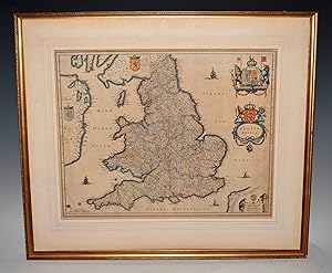
Magnae Britanniae Pars Meridionalis in qua Regnum Anglia tam in Septum Antiqua Anglo-Saxonum Regna
Publication Date: 1730
Seller: Sequitur Books, Boonsboro, MD, U.S.A.
Association Member: IOBA
Seller rating 5 out of 5 stars

Condition: Fair. 65x56cm. Poor condition; damp staining, some tears with loss at margins, partial split at center fold.Hand colored map based on Visscher's map of 1695, delineating counties and showing the boundaries of the seven Anglo-Saxon kingdoms. The map is decorated by a beautiful cartouche surrounded by angels and the British coat of arms. Two other angels hold the Welsh armorial shield, and at bottom is a large vignette of the king holding court. The map is densely engraved with detail including roads. This is the second state of the map with Homann's privilege removed.
-
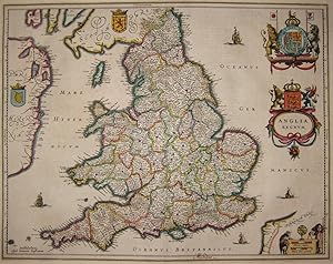
Anglia Regnum - Original Copper Engraved Map - 1650
Language: English
Published by Joan Blaeu, Amsterdam, 1650
US$ 345.42
US$ 33.54 shipping
Ships from United Kingdom to U.S.A.Quantity: 1 available
Add to basketNo Binding. Condition: Very Good. Date: c.1650. Latin text to the reverse. Sheet Size: 56.5cm x 43.4cm. Original or early hand-colouring. Original central fold lines. Minor creasing. Short closed tear to the base of the central fold line which has been repaired to the reverse with archive tape. Very minor age-toning but generally very bright and clean with good margins. A strong impression. Overall in very good condition. Scarce thus.
-

US$ 25.95
Free Shipping
Ships from United Kingdom to U.S.A.Quantity: Over 20 available
Add to basketPaperback. Condition: New. Print on Demand. This book compiles nearly 600 descriptions of plants and animals found in England during the 18th century. The author set out on a six-year journey across the country to document all manner of species, including flowering plants, insects, and birds. Organised by zoological and botanical families, the book is full of fascinating observations, which reflect the author's interest in the interconnections between nature, climate, and human activity. An essential resource for naturalists, this book will appeal to general readers with an interest in the history of natural history. This book is a reproduction of an important historical work, digitally reconstructed using state-of-the-art technology to preserve the original format. In rare cases, an imperfection in the original, such as a blemish or missing page, may be replicated in the book. print-on-demand item.
-

Anglia Regnum
Published by Amsterdam, 1634
Seller: Clive A. Burden Ltd., Chalfont St. Giles, BUCKS, United Kingdom
Seller rating 5 out of 5 stars
Map
US$ 359.23
US$ 29.71 shipping
Ships from United Kingdom to U.S.A.Quantity: 1 available
Add to basketNo binding. 385 x 495 mm., early outline colour, with Spanish text, with tear to the upper margin repaired, in good condition. The Blaeu firm's first topographical atlas appeared in 1630 in one volume and was gradually expanded. By 1640 it was in three volumes and contained just 4 British Isles maps. His chief rival, the Hondius-Jansson atlas contained 18 maps. Both joined a race to make their fourth volumes a complete atlas of the British Isles. Blaeu was first, publishing his magnificent work in 1645. Of the general maps contained Blaeu was also the first to produce one of England and Wales first appearing in 1634. The map is derived from that of John Speed although hear lacking the figures along the sides as befitted the new style being set by the Dutch mapmakers. It is however beautifully decorated with the coats of arms of Great Britain and Ireland along with an ornate scale and title cartouche. There is known to exist a proof state of this map, so technically this is a second state, with Spanish text as issued in 1659. Koeman (1967-70) Bl. 5 no. 107 p. 89; Shirley (1991) no. 440; Van der Krogt, P. (Atlantes) 5100:2.
-
AN ORIGINAL ENGRAVED MAP OF Anglia regnum. Copper engraved map of the Kingdom of England
Published by Atlas Novus Ca 1642, 1642
Seller: PROCTOR / THE ANTIQUE MAP & BOOKSHOP, DORCHESTER, United Kingdom
Association Member: PBFA
Seller rating 5 out of 5 stars
Map
US$ 531.94
US$ 26.83 shipping
Ships from United Kingdom to U.S.A.Quantity: 1 available
Add to basketLg.map (engr.surface 20.5 x 16 inches). In ivory mount. An attractive and decorative map in very good condition. Mount a little tanned. Nicely Original hand-coloured. Jan Jansson Jr (1588-1664), or Johannes Janssonius, was the son of a bookseller and publisher who had worked with Jodocus Hondius Sr. From about 1633 onwards, his imprint appears on the title-pages of the Mercator-Hondius "Atlas", in conjunction with his brother-in-law, Henry, as they re-issued their "Atlas" in competition with the Blaeus.
-
Anglia Regnum, Mercator-Hondius, anno 1630, old colours
Published by Mercator Gerhard, 1512-1594, 1630
Map
Kein Einband. Condition: Gut. Anglia Regnum, Mercator-Hondius, anno 1630, old colours Coppermap, edited by Mercator-Hondius, approx. anno 1630, Original colours, size of the leaf: 47 x 55 cm., french text on verso, wide margins.
-

Anglia Regnum.
Published by Amsterdam, 1630, Latin text edition. 350 x 460mm (13� x 18 inches)., 1630
Seller: Tooley, Adams & Co., Wallingford, OXON, United Kingdom
Seller rating 3 out of 5 stars

US$ 525.03
US$ 49.83 shipping
Ships from United Kingdom to U.S.A.Quantity: 1 available
Add to basketUncoloured; minor marginal nicks and toning to the edges of the paper, short repaired tear to lower centrefold in the margin, small rust spot in Ireland, otherwise a very good example. Mercator's map of England and Wales is on a larger scale than his map of the British Isles, because of this he is able to include more place names. Although based on Saxton, there are some curious spellings of places, suggesting perhaps that the engraver was using a foreign source. SHIRLEY: No.181. KOEMAN: Me 29A.
-
Anglia regnum
Published by c.1623, Amsterdam, 1623
Seller: Alexandre Antique Prints, Maps & Books, Toronto, ON, Canada
Seller rating 4 out of 5 stars

Map
Condition: Very Good. A highly detailed and beautiful map of England. Latin text on verso. Gerardus Mercator (1512?1594) was a Flemish geographer, cosmographer and cartographer. He is most renowned for creating the 1569 world map based on a new projection which represented sailing courses of constant bearing (rhumb lines) as straight lines. Mercator was a notable maker of globes and scientific instruments. He also had interests in theology, philosophy, history, mathematics, and geomagnetism. He was also an accomplished engraver and calligrapher., Size : 470x354 (mm), 18.50x13.94 (Inches), Original Hand Coloring.
-
EARLY LARGE RARE MAP OF ENGLAND 1595 " Anglia Regnum." From the French text edition of Mercator?s Atlas III
Published by Duisberg 1595, 1595
Seller: PROCTOR / THE ANTIQUE MAP & BOOKSHOP, DORCHESTER, United Kingdom
Association Member: PBFA
Seller rating 5 out of 5 stars
US$ 577.54
US$ 26.83 shipping
Ships from United Kingdom to U.S.A.Quantity: 1 available
Add to basketLarge coloured map held in wooden frame with glass front. Engraved Size 47cm x 35cm Frame Size 66cm x 56cm Very good. Large Margins, with a few faint marks. Old frame has small chip on hand hand side. FRENCH text to verso. ORIGINAL slightly GARISH HAND COLOURING This hand colored first state Mercator map of Great Britain of 1595 is a highly detailed rendering of England as it was at the end of the 16th century. Eastern Ireland and the west coast of Holland, Belgium and France are also included. Cities, ports, churches, estates and forts are included in the map, and it is embellished by a lovely frigate sailing off the coast between Holland and Suffolk.
-

Anglia Regnum.
Published by Amsterdam, 1636-. French text edition. 390 x 500mm (15� x 19� inches)., 1636
Seller: Tooley, Adams & Co., Wallingford, OXON, United Kingdom
Seller rating 3 out of 5 stars
US$ 580.30
US$ 49.83 shipping
Ships from United Kingdom to U.S.A.Quantity: 1 available
Add to basketFinely coloured; very slight age-toning as is often the case with maps by Jansson, minor nicks to the edges of the paper, short centrefold split to lower margin, repaired, otherwise a fine example. One of the most attractive early Dutch maps of England and Wales available.
-

Magnae Britanniae pars meridionalis in qua Regnum Anglia .
Published by Artist: Homann Johann Babtiste ( - 1724 ) Nuremberg ca : 1710, 1664
Seller: Antique Sommer& Sapunaru KG, M�nchen, Germany
Seller rating 4 out of 5 stars
Technic: Copper print, colorit: original colored, condition: Very good, size (in cm): 55 x 48 cm, Map shows the whole of England with magnificent cartouches.
-

Anglia Regnum si quod Aliud in Toto Oceano Ditissimum et Florentissimum
Published by Paris, 1605
Seller: Clive A. Burden Ltd., Chalfont St. Giles, BUCKS, United Kingdom
Seller rating 5 out of 5 stars
Map
US$ 2,556.08
US$ 29.71 shipping
Ships from United Kingdom to U.S.A.Quantity: 1 available
Add to basketNo binding. Condition: Good. 385 x 480 mm., with double folds as usual, small tear at double fold professionally repaired, otherwise in good condition. Jean Le Clerc (1560-c.1621) was an engraver, bookseller, and publisher who spent a number of years in Tours before moving to Paris sometime around 1594. This very rare map is derived from the Abraham Ortelius - Christopher Saxton map of 1603, itself ultimately from Saxton's map of 1579. This example is in the second state with his name present. The first is extremely rare. It replicates Saxton's map of England of 1579 in a beautifully engraved style. A naval battle is taking place off the Cornish coast. Le Clerc is most noted for his separately published set of continental maps c.1602. In 1619 Le Clerc re-issued Maurice Bouguereau's 'Theatre Francois' of 1594 as the 'Theatre Geographique du Royaume de France' and included many new plates. A good example of a beautifully engraved map often found in poor condition. Provenance: Clive A. Burden Ltd. 2009; private English collection. Kelly (2007); Loeb-Larocque (1989); Pastoureau (1984) Le Clerc; Shirley (1991) 271.
-

Anglia Regnum.
Published by Amsterdam, 1633, French text edition. 350 x 460mm (13� x 18 inches)., 1633
Seller: Tooley, Adams & Co., Wallingford, OXON, United Kingdom
Seller rating 3 out of 5 stars
US$ 773.73
US$ 49.83 shipping
Ships from United Kingdom to U.S.A.Quantity: 1 available
Add to basketFine original colour; minor marginal defects, otherwise a very good example. Mercator's map of England and Wales is on a larger scale than his map of the British Isles, because of this he is able to include more place names. Although based on Saxton, there are some curious spellings of places, suggesting perhaps that the engraver was using a foreign source. SHIRLEY: No.181. KOEMAN: Me 36A.
-
Anglia, Regnum si quod aliud in toto Oceano ditissimum et florentissimum
Published by c.1603, Antwerp, Belgium, 1603
Seller: Alexandre Antique Prints, Maps & Books, Toronto, ON, Canada
Seller rating 4 out of 5 stars
Map
Condition: Very Good, margins extended. Important map of United Kingdom by Ortelius based on an earlier map by Christopher Saxton in 1579., Size : 384x483 (mm), 15.12x19.02 (Inches), Hand Colored.
-

Anglia Regnum.
Published by Anversa, Jean Baptiste Vrients, 1603
Seller: Libreria Ex Libris ALAI-ILAB/LILA member, Roma, RM, Italy
Seller rating 5 out of 5 stars
Map
Incisione originale su rame (cm. 48,8x39 pi� margini) tratta dal 'Theatrum Orbis Terrarum'. Splendida coloritura antica all'acquarello. Abili restauri lungo la piegatura centrale e lievi tracce di ossidazione ma buon esemplare. Provenienza: Biblioteca del Castello di Cirey. Van den Broecke, 20.
-
Anglia Regnum si quod aliud in toto Oceano ditissimum et florentissimum (England)
Published by Antwerp, 1603
Seller: Arader Galleries of Philadelphia, PA, Philadelphia, PA, U.S.A.
Seller rating 4 out of 5 stars
N/A. Condition: Very Good. Dust Jacket Condition: N/A. Engraving with original hand-color. Sheet size: 17 1/4 x 22". Inventory#: p1372pmat.
-
Anglia Regnum
Published by c. 1633, Amsterdam, 1633
Seller: Alexandre Antique Prints, Maps & Books, Toronto, ON, Canada
Seller rating 4 out of 5 stars
Map
Early Latin example of Mercator\\\\\\\\\\\\\\\'s map of Great Britain first published in \"Atlas Sive Cosmographia.\\\" Includes a decorative cartouche and a ship at sale. French text on Verso. , Size : 349x467 (mm), 13.75x18.40 (Inches), Hand Colored Map is strengthened by acid free tissue paper for long term preservation. Otherwise, Generally Good.
-

Anglia Regnum in Omnes Suos Ducatus, Comitatus, et Provincias Divisum.
Published by Amsterdam, 1680
Seller: Alexandre Antique Prints, Maps & Books, Toronto, ON, Canada
Seller rating 4 out of 5 stars
Map
Size : 575x485 (mm), 22.625x19.125 (Inches), Original Hand Coloring, 0 Very Good, laid on contemporary thick paper. Some browning due to the colour transfer of the image on the opposite page while in atlas.
-
LeatherBound. Condition: New. BOOKS ARE EXEMPT FROM IMPORT DUTIES AND TARIFFS; NO EXTRA CHARGES APPLY. LeatherBound edition. Condition: New. Reprinted from 1599 edition. Leather Binding on Spine and Corners with Golden leaf printing on spine. NO changes have been made to the original text. This is NOT a retyped or an ocr'd reprint. Illustrations, Index, if any, are included in black and white. Each page is checked manually before printing. Pages: 243 As this print on demand book is reprinted from a very old book, there could be some missing or flawed pages, but we always try to make the book as complete as possible. Fold-outs, if any, are not part of the book. If the original book was published in multiple volumes then this reprint is of only one volume, not the whole set. Sewing binding for longer life, where the book block is actually sewn (smythe sewn/section sewn) with thread before binding which results in a more durable type of binding. Pages: 243 Language: Latin.
-
![Seller image for Tragoedia Anglicana, siue, De Nvperae Anglorvm Qvorvndam Contra Regem & regnum Conivrationis initio, progressu [et] fine, deque supplicio a coniuratis sumto Narratio0 a libellis in Anglia editis desumta. cum [et] sine figuris aeneis 1606 [LeatherBound] for sale by True World of Books](https://pictures.abebooks.com/inventory/md/md31616472395.jpg)
LeatherBound. Condition: New. BOOKS ARE EXEMPT FROM IMPORT DUTIES AND TARIFFS; NO EXTRA CHARGES APPLY. LeatherBound edition. Condition: New. Reprinted from 1606 edition. Leather Binding on Spine and Corners with Golden leaf printing on spine. Bound in genuine leather with Satin ribbon page markers and Spine with raised gilt bands. A perfect gift for your loved ones. Pages: 55 NO changes have been made to the original text. This is NOT a retyped or an ocr'd reprint. Illustrations, Index, if any, are included in black and white. Each page is checked manually before printing. As this print on demand book is reprinted from a very old book, there could be some missing or flawed pages, but we always try to make the book as complete as possible. Fold-outs, if any, are not part of the book. If the original book was published in multiple volumes then this reprint is of only one volume, not the whole set. Sewing binding for longer life, where the book block is actually sewn (smythe sewn/section sewn) with thread before binding which results in a more durable type of binding. Pages: 55.
-
Leather Bound. Condition: New. Language: Latin. Language: Latin. Presenting an Exquisite Leather-Bound Edition, expertly crafted with Original Natural Leather that gracefully adorns the spine and corners. The allure continues with Golden Leaf Printing that adds a touch of elegance, while Hand Embossing on the rounded spine lends an artistic flair. This masterpiece has been meticulously reprinted in 2025, utilizing the invaluable guidance of the original edition published many years ago in 1606. The contents of this book are presented in classic black and white. Its durability is ensured through a meticulous sewing binding technique, enhancing its longevity. Imprinted on top-tier quality paper. A team of professionals has expertly processed each page, delicately preserving its content without alteration. Due to the vintage nature of these books, every page has been manually restored for legibility. However, in certain instances, occasional blurriness, missing segments, or faint black spots might persist. We sincerely hope for your understanding of the challenges we faced with these books. Recognizing their significance for readers seeking insight into our historical treasure, we've diligently restored and reissued them. Our intention is to offer this valuable resource once again. We eagerly await your feedback, hoping that you'll find it appealing and will generously share your thoughts and recommendations. Lang: - Latin, Pages:- 56, Print on Demand. If it is a multi-volume set, then it is only a single volume. We are specialised in Customisation of books, if you wish to opt different color leather binding, you may contact us. This service is chargeable. Product Disclaimer: Kindly be informed that, owing to the inherent nature of leather as a natural material, minor discolorations or textural variations may be perceptible. Explore the FOLIO EDITION (12x19 Inches): Available Upon Request. 56 56.
-
![Seller image for Tragoedia Anglicana, siue, De Nvperae Anglorvm Qvorvndam Contra Regem & regnum Conivrationis initio, progressu [et] fine, deque supplicio a coniuratis sumto Narratio0 a libellis in Anglia editis desumta. cum [et] sine figuris aeneis 1533 [LeatherBound] for sale by True World of Books](https://pictures.abebooks.com/inventory/md/md31617458010.jpg)
LeatherBound. Condition: New. BOOKS ARE EXEMPT FROM IMPORT DUTIES AND TARIFFS; NO EXTRA CHARGES APPLY. LeatherBound edition. Condition: New. Reprinted from 1533 edition. Leather Binding on Spine and Corners with Golden leaf printing on spine. Bound in genuine leather with Satin ribbon page markers and Spine with raised gilt bands. A perfect gift for your loved ones. Pages: 603 NO changes have been made to the original text. This is NOT a retyped or an ocr'd reprint. Illustrations, Index, if any, are included in black and white. Each page is checked manually before printing. As this print on demand book is reprinted from a very old book, there could be some missing or flawed pages, but we always try to make the book as complete as possible. Fold-outs, if any, are not part of the book. If the original book was published in multiple volumes then this reprint is of only one volume, not the whole set. Sewing binding for longer life, where the book block is actually sewn (smythe sewn/section sewn) with thread before binding which results in a more durable type of binding. Pages: 603.
-
Leather Bound. Condition: New. Language: Latin. Language: Latin. Presenting an Exquisite Leather-Bound Edition, expertly crafted with Original Natural Leather that gracefully adorns the spine and corners. The allure continues with Golden Leaf Printing that adds a touch of elegance, while Hand Embossing on the rounded spine lends an artistic flair. This masterpiece has been meticulously reprinted in 2024, utilizing the invaluable guidance of the original edition published many years ago in 1599. The contents of this book are presented in classic black and white. Its durability is ensured through a meticulous sewing binding technique, enhancing its longevity. Imprinted on top-tier quality paper. A team of professionals has expertly processed each page, delicately preserving its content without alteration. Due to the vintage nature of these books, every page has been manually restored for legibility. However, in certain instances, occasional blurriness, missing segments, or faint black spots might persist. We sincerely hope for your understanding of the challenges we faced with these books. Recognizing their significance for readers seeking insight into our historical treasure, we've diligently restored and reissued them. Our intention is to offer this valuable resource once again. We eagerly await your feedback, hoping that you'll find it appealing and will generously share your thoughts and recommendations. Lang: - Latin, Pages: : - 240, Print on Demand. If it is a multi-volume set, then it is only a single volume. We are specialised in Customisation of books, if you wish to opt different color leather binding, you may contact us. This service is chargeable. Product Disclaimer: Kindly be informed that, owing to the inherent nature of leather as a natural material, minor discolorations or textural variations may be perceptible. Explore the FOLIO EDITION (12x19 Inches): Available Upon Request. 240 240.
-

Magnae Britanniae Pars Meridionalis in qua Regnum Anglia tam in Septum Antiqua Anglo-Saxonum Regna (.)
Published by J.B. Homann, 1730
Seller: Antiquariaat Dat Narrenschip, Middelburg, Netherlands
Seller rating 5 out of 5 stars
Map
No Binding. Condition: Good. Antique map of England and Wales. Top right cartouche with title and publisher's imprint. At the bottom a decorative vignette with an image of a government council with a British monarch. Scale sticks bottom left. Backside blank. Copper engraving with partial old colour, published around 1730 in Nuremberg by Johann Baptist Homann. Bottom right, near London, a professionally restored tear. Some small tears have been repaired in the margins. Dimensions (image): 58 x 49 cm.
-

Anglia regnum
Published by Jodocus Hondius, 1619
Seller: Antiquariaat Dat Narrenschip, Middelburg, Netherlands
Seller rating 5 out of 5 stars
Map
No Binding. Condition: Fine. Antique map of England. Title cartouche with scale stick top right. Latin text on the back. Hand-coloured copper engraving, made by Gerard Mercator in 1585. Published in Amsterdam in 1619 by Jodocus Hondius in "Atlas Sive Cosmographicae Meditationes De Fabrica Mundi Et Fabricati Figura. (.)." A tear in the center fold below was repaired on verso. Dimensions (image): 36 x 47 cm.
-

1646 - ANGLIA REGNUM England and Wales Map by Jan Jansson after Blaeu (LM10)
Seller: Antique Paper Company, ASHFORD, KENT, United Kingdom
Seller rating 2 out of 5 stars

Map
US$ 493.95
US$ 8.05 shipping
Ships from United Kingdom to U.S.A.Quantity: 1 available
Add to basketHomeAbout UsView FeedbackContact Us1646 - ANGLIA REGNUM England Wales Map by Jan Jansson after Blaeu (LM10) 1646A large original antique print map titledANGLIA REGNUM A highly decorative copper engraved 17th Century Map England by Jan Jansson. The design for this map was based on the earlier maps by Blaeu and the difference with this one compared to the Blaeu map is that Jansson signed the map at the bottom left and also inserted the Lion Crown small coat of arms at the top, just left of the centrefold. Also showing fine title cartouche and decorative coats-of-arms with later hand colouring and Latin text on verso.Generally very good condition with central fold as issued. Approx 57cmx 47cm with large margins, perfect for mounting and framing.Jan Jansson (1588-1664) (also known as Johan or or Janszoon) was a renowned geographer and publisher of the 17th century, when the Dutch dominated map publishing in Europe. Born in Arnhem, Jan was first exposed to the trade via his father, who was also a bookseller and published. In 1612, Jan married the daighter of Jodocus Hondius, who was also a prominent mapmaker and seller. Janssons first maps date from 1616. In the 1930s, Jansson worked with his brother-in-law, Henricus Hondius. Their most success venture was to reissue the Mercator-Hondius atlas. Jodocus Hondius had acquired the plates to the Mercator atlas, first published in 1595, and added 36 additional maps. After Hondius died in 1612, Henricus took over publication; Jansson joined the venture in 1633. Eventually, the atlas was renamed theAtlas Novusand thenAtlas Major, by which time it had expanded to eleven volumes. Jansson is also well known for his volume of English country maps published in 1646. Jansson died in Amsterdan in 1664. His son-in-law, Johannes van Waesbergen, took over his business. Eventually, many of Janssons plates were sold to Gerard Valck and Pieter Schend, who added their names and continued to reissue the maps. View Our Categories Decorative Prints World Wide Maps Scotland Maps Architecture Design England Maps RoyaltyAbout UsWe specialise in selling all items that can be considered to be Antique Paper. * PRINTS * MAPS * HISTORICAL DOCUMENTS * POSTAL HISTORY * BOOKS * POSTERS * STAMPS * POSTCARDS * EPHEMERA And anything else that is considered Antique and made of Paper. ALL OF OUR ITEMS ARE ORIGINAL ANTIQUES - NOT MODERN COPIES. We are also very keen buyers of anything similar and especially after better collections, original archives, whole libraries and better single items and have andpound;250,000 in cash funds at anyone time to buy the right items.Contact UsIf you have any questions then please do not hesitate to contact us through the eBay messaging system.FeedbackWe will always help you to have a 100% positive happy buying experience. Contact us if you are unhappy about any aspect of your purchase from us. We only want five star feedback from you so buy with confidence.
-

Kupferstich- Karte, b. Janssonius & Hondius, "Anglia Regnum".
Language: German
Seller: Antiquariat Clemens Paulusch GmbH, Berlin, Germany
Seller rating 5 out of 5 stars
Map
mit altem Grenzkolorit, 1638, 39 x 50 Koeman's Atlantes Neerlandici, 5100:1B Shirley, British Isles ( 1477 - 1650 ), Nr. 482. - Am rechten Rand Titelkartusche mit Wappen, dar�ber gro�es Wappen.
-
Anglia regnum
Language: German
Publication Date: 1642
Seller: Kunstantiquariat Andreas Senger, Hamburg, Germany
Seller rating 5 out of 5 stars
Map
Kein Einband. Condition: Gut. Es handelt sich hierbei um eine originale, kolorierte Kupferstich-Landkarte des K�nigreichs England von Johann Janssonius (1588 - 1664) aus dem Jahr 1642. *** Titel: Anglia regnum *** Gebiet bzw. Ort: England, Gro�britannien *** Kartograph: Johann Janssonius (1588 - 1664) *** Jahr: 1642 *** Gr��e des Plattenbereichs: 39 x 50 cm *** Technik: Kupferstich *** Zustand (Perfekt/ Sehr gut/ Gut/ Ordentlich/ M��ig/ Schlecht): In gutem Erhaltungszustand *** Bemerkungen: - - - - International buyers welcome. If you have any questions, please don't hesitate to ask. - - - ----- Auf Wunsch stellen wir Ihnen gerne ein kostenfreies Echtheitszertifikat aus ------ If you wish, we will gladly provide a certificate of authenticity free of charge ---.
-

c1680 Large Map ENGLAND WALES Anglia Regnum in Omnes Suos Ducatus de Wit (LM10)
Seller: Antique Paper Company, ASHFORD, KENT, United Kingdom
Seller rating 2 out of 5 stars
US$ 400.68
US$ 8.05 shipping
Ships from United Kingdom to U.S.A.Quantity: 1 available
Add to basketListing Template 2018 Home About Us View Feedback Contact Us c1680 Large Map ENGLAND WALES Anglia Regnum in Omnes Suos Ducatus de Wit (LM10)Descriptionc1680A large original engravedmap titledAnglia Regnum in Omnes suos Ducatus, Comitatus, et Provincias DivisumAfineexample of the scarce first edition of this map of England and Wales by Frederic de Wit. Original outline colour defines the counties and highlights the coat of arms at upper right. The title appears in a simple line at the top of the map. Frederick De Wit (1610-1698) was a prolific Dutch engraver and publisher, active in Amsterdam in the second half of the seventeenth century. He acquired a number of copperplates from the sale of the Blaeu and Jansson stocks to supplement his own plates, thus having a stock of about four hundred maps. De Wit's own maps are noted for the fine standard of engraving, are invariably well designed and decorative. They were very popular amongst his contemporaries, being reprinted many times both by himself and his successors, the Mortiers.Very good condition with central foldas issued.Size approx 50cm x 60cm View Our Categories Decorative Prints World Wide Maps Scotland Maps Architecture Design England Maps Royalty About UsWe specialise in selling all items that can be considered to be Antique Paper. * PRINTS * MAPS * HISTORICAL DOCUMENTS * POSTAL HISTORY * BOOKS * POSTERS * STAMPS * POSTCARDS * EPHEMERA And anything else that is considered Antique and made of Paper. ALL OF OUR ITEMS ARE ORIGINAL ANTIQUES - NOT MODERN COPIES. We are also very keen buyers of anything similar and especially after better collections, original archives, whole libraries and better single items and have and#163;250,000 in cash funds at anyone time to buy the right items. Contact UsIf you have any questions then please do not hesitate to contact us through the eBay messaging system. Feedback We will always help you to have a 100% positive happy buying experience. Contact us if you are unhappy about any aspect of your purchase from us. We only want five star feedback from you so buy with confidence.
-

1659 Antique Map ANGLIA REGNUM England Wales by Blaeu Spanish Edition (EB)
Seller: Antique Paper Company, ASHFORD, KENT, United Kingdom
Seller rating 2 out of 5 stars
US$ 449.04
US$ 8.05 shipping
Ships from United Kingdom to U.S.A.Quantity: 1 available
Add to basketListing Template 2018 Home About Us View Feedback Contact Us 1659 Antique Map ANGLIA REGNUM England Wales by Blaeu Spanish Edition (EB)Description1659ANGLIA REGNUMA highly decorative and sought afterengraved 17th Century Map of England Wales with the two Royal Coats of Arms. The reverse of the map is a completeset of text in Spanish describing the history and topography of the county.Measures 450x 570mm with early hand colouring.For much of the 17th Century the firm of Blaeu were the dominant mapmakers at a time when Dutch cartography was universally acknowledged to lead the world. Established in 1596 by Willem Janszoon Blaeu (1571-1638), who had studied as a young man under the great astronomer, Tycho Brahe, it originally produced globes and scientific instruments. However, the firm soon expanded into map-making and publishing, and eventually became one of the most important and prolific map producers in Amsterdam.In 1623 they published 'Het Licht der Zeevaerdt'an atlas of sea-charts. In 1629 Willem and his son Jan (1596-1673) purchased 37 engraved plates from the widow of their rival Hondius and the following year they produced their first land atlas, the Atlantis Appendixwhich contained sixty maps. In 1635 this was expanded into the Atlas Novus a major world atlas in six volumes. This contained a county atlas of England and Wales and from 1635-59 was published in editions in Dutch, Latin, French, German and Spanish.After the death of his father, Jan (also spelt Joan or Johannes) Blaeu embarked on one of the most ambitious publishing undertakings of the 17th Century, the printing of the 'Atlas Maior'.This magnificent work was to contain nearly six hundred maps and, depending on the edition, varied between nine and twelve volumes. Exquisite engraving allied with typically lovely hand-colouring make maps from the 'Novus'and 'Maior'atlases some of the finest ever produced.The 'Atlas Maior'was to be the crowning glory of the Blaeu firm, but in 1672 a disastrous fire swept through the Blaeu printing house destroying much of the stock and most of the engraved copperplates. The following year Jan died and the surviving plates were dispersed.The period between 1570 and 1670 is known as the Golden Age of Dutch Cartography and it is a measure of the Blaeuand#8217;s achievements that they were the dominant cartographers throughout most of this period. Reflecting their contemporary reputations Willem and Jan were in turn both appointed Hydrographer to the Dutch East India Company (the VOC) and their atlases were frequently presented to foreign sovereigns and potentates by the Dutch government.Original antique Mapis in outstanding condition with the usual central fold as issued. View Our Categories Decorative Prints World Wide Maps Scotland Maps Architecture Design England Maps Royalty About UsWe specialise in selling all items that can be considered to be Antique Paper. * PRINTS * MAPS * HISTORICAL DOCUMENTS * POSTAL HISTORY * BOOKS * POSTERS * STAMPS * POSTCARDS * EPHEMERA And anything else that is considered Antique and made of Paper. ALL OF OUR ITEMS ARE ORIGINAL ANTIQUES - NOT MODERN COPIES. We are also very keen buyers of anything similar and especially after better collections, original archives, whole libraries and better single items and have and#163;250,000 in cash funds at anyone time to buy the right items. Contact UsIf you have any questions then please do not hesitate to contact us through the eBay messaging system. Feedback We will always help you to have a 100% positive happy buying experience. Contact us if you are unhappy about any aspect of your purchase from us. We only want five star feedback from you so buy with confidence.


![Seller image for Tragoedia Anglicana, siue, De Nvperae Anglorvm Qvorvndam Contra Regem & regnum Conivrationis initio, progressu [et] fine, deque supplicio � coniuratis sumto Narratio: � libellis in Anglia editis desumta. cum [et] sine figuris aeneis 1606 [Leather Bound] for sale by Gyan Books Pvt. Ltd.](https://pictures.abebooks.com/inventory/md/md31965282336.jpg)