
Order Total (1 Item Items):
Shipping Destination:

Atlas Minor by Seutter Matthaeus (9 results)
Feedback
Skip to main search results
Search filters
Product Type
- All Product Types
- Books (3)
- Magazines & Periodicals (No further results match this refinement)
- Comics (No further results match this refinement)
- Sheet Music (No further results match this refinement)
- Art, Prints & Posters (No further results match this refinement)
- Photographs (No further results match this refinement)
- Maps (6)
- Manuscripts & Paper Collectibles (No further results match this refinement)
Condition Learn more
- New (No further results match this refinement)
- As New, Fine or Near Fine (No further results match this refinement)
- Very Good or Good (6)
- Fair or Poor (No further results match this refinement)
- As Described (3)
Binding
- All Bindings
- Hardcover (No further results match this refinement)
- Softcover (1)
Collectible Attributes
- First Edition (No further results match this refinement)
- Signed (No further results match this refinement)
- Dust Jacket (No further results match this refinement)
- Seller-Supplied Images (9)
- Not Print on Demand (9)
Language (2)
Price
- Any Price
- Under US$ 25 (No further results match this refinement)
- US$ 25 to US$ 50 (No further results match this refinement)
- Over US$ 50
Free Shipping
Seller Location
Seller Rating
-
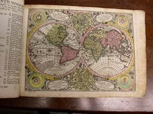
Atlas Minor.
Published by Augsburg: [c1744]., 1744
Seller: D & E LAKE LTD. (ABAC/ILAB), Toronto, ON, Canada
Seller rating 4 out of 5 stars

US$ 19,200.00
Convert currencyUS$ 15.00 shipping from Canada to U.S.A.Quantity: 1 available
Add to basketSoft cover. Condition: Very Good. oblong folio. [pp. 34]. hand-coloured engraved title with an elaborate allegorical border of the Continents, Empire and the Gods by Martin Gottfrid Crophius after Jacob Christoph Weyerman & 65 hand-coloured engraved maps by Tobias Conrad Lotter, Albrecht Carl Seutter, & Andreas Silbereisen after Matth�us Seutter & Albrecht Carl Seutter. woodcut tailpiece. contemporary limp calf (rubbed & cockled, edges chipped, staining to portion of last 4 maps, scattered foxing & some marginal dampstaining & minor tears, several tiny wormholes in first few leaves). An attractive atlas by one of the leading eighteenth century German map publishers and engravers. Including maps of the world, North America, South America, Asia, Africa, Russia, the Turkish Empire, Southern Russia and the Crimea, the Holy Land, and various countries and regions of Europe. The map of Genoa, by Matth�us Petter L�inpacher, does not appear in the index. cfNordenski�ld 283 (67 maps; 4 not listed in index). cfPhillips, Atlases, 3494 (68 maps: 4 not listed in index).
-
Atlas Minor . (Frontespizio)
Published by Frontespizio
Seller: Sergio Trippini, Gavirate, VA, Italy
Seller rating 4 out of 5 stars
US$ 144.81
Convert currencyUS$ 53.89 shipping from Italy to U.S.A.Quantity: 1 available
Add to basketIncisione, antica ed originale, raffigurante il frontespizio dell'opera "Atlas Minor praecipua Orbis Terrarum Imperia Regna et Provincias Germaniae Potissimum" pubblicata ad Augusta. La stampa, in coloritura coeva, � appilcata su margini anticamente riportati.
-
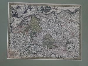
Kolorierte Kupferstichkarte - Imperium Romano-GErmanicum insuos circulos elect et Status suma cura et Studio divisum aeri insulpt. aus Atlas minor praecipua orbis terrarum imperia.
Published by ohne Verlagsangabe, 1744
Language: German
Map
US$ 108.60
Convert currencyUS$ 84.94 shipping from Austria to U.S.A.Quantity: 1 available
Add to basketca 25,5 x 20 cm. Condition: Gut. Erstauflage, EA. 1 Blatt sch�ne kolorierte Kupferstichkarte mit Titelkartusche hinter Pasepartout, mit Passepartout 40 x 30 cm, ohne Passepartout ca 25,5 x 20 cm, unten im linken Eck zarter Fleck, sonst guter Zustand Sprache: Deutsch Gewicht in Gramm: 1100.
-
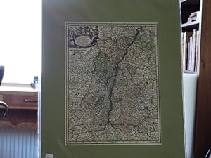
Kolorierte Kupferstichkarte - Alsatia Landgraviatus cum utroque Marchionatu Badensi Sundgovia Brisgovia. aus Atlas minor praecipua orbis terrarum imperia.
Published by ohne Verlagsangabe, 1744
Language: German
Map
US$ 130.33
Convert currencyUS$ 84.94 shipping from Austria to U.S.A.Quantity: 1 available
Add to basketca 26,5 x 20 cm. Condition: Gut. Erstauflage, EA. 1 Blatt sch�ne kolorierte Kupferstichkarte mit Titelkartusche hinter Pasepartout, mit Passepartout 40 x 30 cm, ohne Passepartout ca 26,5 x 20 cm, guter Zustand Sprache: Deutsch Gewicht in Gramm: 1100.
-
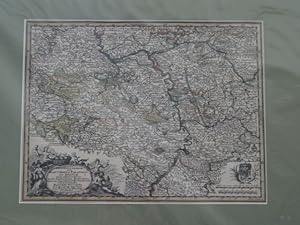
Kolorierte Kupferstichkarte - Platinatus Inferior sive Electoratus Palatinus ad Rhenum cum adjacentibus Archi Episcopatu Moguntino Episcop Spirensi et Wormatiensi.axon. aus Atlas minor praecipua orbis terrarum imperia.
Published by ohne Verlagsangabe, 1744
Language: German
Map
US$ 130.33
Convert currencyUS$ 84.94 shipping from Austria to U.S.A.Quantity: 1 available
Add to basketca 25,5 x 20 cm. Condition: Gut. Erstauflage, EA. 1 Blatt sch�ne kolorierte Kupferstichkarte mit Titelkartusche hinter Pasepartout, mit Passepartout 40 x 30 cm, ohne Passepartout ca 25,5 x 20 cm, guter Zustand Sprache: Deutsch Gewicht in Gramm: 1100.
-
Kolorierte Kupferstichkarte - Circulus Bavaria in fuas quasq didion tam cum finitimis quam infertis Regionibus accuratissime divileri incis et venal exposit. aus Atlas minor praecipua orbis terrarum imperia.
Published by ohne Verlagsangabe, 1744
Language: German
Map
US$ 130.33
Convert currencyUS$ 84.94 shipping from Austria to U.S.A.Quantity: 1 available
Add to basketca 25,5 x 20 cm. Condition: Gut. Erstauflage, EA. 1 Blatt sch�ne kolorierte Kupferstichkarte mit Titelkartusche hinter Pasepartout, mit Passepartout 40 x 30 cm, ohne Passepartout ca 25,5 x 20 cm, guter Zustand Sprache: Deutsch Gewicht in Gramm: 1100.
-

Ierusalem, cum suburbiis, prout tempore Christi floruit . Abriss der Weltberuehmten Statt Ierusalem . nach dem Christ. Andrichomii abgezeichnet u. in Kupf(er) gestochen. Altkolorierter Kupferstich aus: Atlas minor. Praecipua orbis terrarum imperia.
Published by Augsburg, Tobias Conrad Lotter, (ca. 1756)., 1756
Language: German
Seller: Matthaeus Truppe Antiquariat, Graz, Austria
Seller rating 5 out of 5 stars

Map
US$ 1,291.19
Convert currencyUS$ 72.64 shipping from Austria to U.S.A.Quantity: 1 available
Add to basketCa. 57 cm x 49 cm. Gerahmt. Die bei Tobias Lotter gedruckte zweite Auflage dieses Plans der Stadt Jerusalem im Altertum von Matth�us Seutter (erstmals in dessen "Atlas Novus" von 1741 gedruckt). - Der Plan basiert im Wesentlichen auf jenem von Christian van Adrichom des Jahres 1584. Im unteren Drittel eine "Beschreibung der Statt Jerusalem, samt einer Erkl�rung was eine jede Ziffer Zahl in diesem Abri� derselben bedeute". - Leicht fleckig. *** *** Copyright: Matthaeus TRUPPE Buchhandlung & Antiquariat - Stubenberggasse 7 - A-8010 Graz - ++43 (0)316 - 829552 *** *** Sprache: Deutsch Gewicht in Gramm: 0.
-
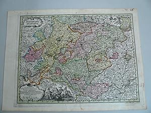
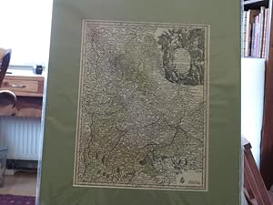
Franken-Circulus Franconicus, Seutter Matthaeus, Atlas Minor -anno 1740--- Franken-Circulus Franconicus, Seutter Matthaeus, Atlas Minor Altkoloriert, zeigt Franken, Blatt: 22 x 30 cm.
Publication Date: 1740
Map
US$ 96.54
Convert currencyUS$ 35.15 shipping from Germany to U.S.A.Quantity: 1 available
Add to basketKein Einband. Condition: Gut. Franken-Circulus Franconicus, Seutter Matthaeus, Atlas Minor -anno 1740--- Franken-Circulus Franconicus, Seutter Matthaeus, Atlas Minor Altkoloriert, zeigt Franken, Blatt: 22 x 30 cm.
-
(Atlas Minor) - Atlantis Minoris.
Seller: Herman H. J. Lynge & S�n ILAB-ABF, Copenhagen, Denmark
Seller rating 4 out of 5 stars
US$ 5,254.29
Convert currencyFree shipping from Denmark to U.S.A.Quantity: 1 available
Add to basketAugsburg, August� Vind, (1744). 4to-oblong. Cont. hcalf. Back and covers somewhat worn. Platesizes ca. 20,5 x 27 cm. (32) pp. and 60 full-page engraved maps (of 64 listed). Lacking the engraved title and 5 other maps (Africa, America septentrionalis, Regum Portugalli�, Regnum Hispani�, Italia totur and Pal�stina), but having 2 more not listed and some in the German section does not corresponds with the maps listed in the index. All maps in original handcolouring, occasionally a little brownspotted and traces of use in lower right corners. One map have a little loss of image in lower middle (Austria Saliburgensis). Phillips No 3494. 2 maps relating to America (Globus Terrestris (World Map) and America Meridionalis). Having maps of Europe, Asia, Russia, Turkey, Scandinavia etc. The World Map engraved by Andr. Silbereisen and most of the other maps engraved by A.C. Seutter and Tobias C. Lotter (married to Seutters daughter and his successor).

