
Order Total (1 Item Items):
Shipping Destination:

Australia by Map (113 results)
Skip to main search results
Search filters
Product Type
- All Product Types
- Books (62)
- Magazines & Periodicals (1)
- Comics (No further results match this refinement)
- Sheet Music (No further results match this refinement)
- Art, Prints & Posters (7)
- Photographs (No further results match this refinement)
- Maps (43)
- Manuscripts & Paper Collectibles (No further results match this refinement)
Condition Learn more
Binding
Collectible Attributes
- First Edition (26)
- Signed (No further results match this refinement)
- Dust Jacket (1)
- Seller-Supplied Images (74)
- Not Print on Demand (113)
Language (4)
Free Shipping
Seller Location
Seller Rating
-

Aborigines of Australia.
Language: English
Published by Lothrop, Lee & Shepard Co., 1969
ISBN 10: 0688411517 ISBN 13: 9780688411510
Seller: Wonder Book, Frederick, MD, U.S.A.
Seller rating 5 out of 5 stars

Condition: Fair. Joan Maestro (Map) (illustrator). Acceptable condition. No Dust Jacket Former Library book. A readable, intact copy that may have noticeable tears and wear to the spine. All pages of text are present, but they may include extensive notes and highlighting or be heavily stained. Includes reading copy only books. Bundled media such as CDs, DVDs, floppy disks or access codes may not be included.
-

Rain Forest Into Desert Adventures In Australia s Tropical North
Language: English
Published by University Press Of Colorado, 1994
ISBN 10: 087081334X ISBN 13: 9780870813344
Seller: Terrace Horticultural Books, St. Paul, MN, U.S.A.
Seller rating 4 out of 5 stars

First Edition
Hardcover. Condition: As New. B & W Photos, Map (illustrator). First Edition. Copyright Date: 1994 Sm Quarto, , pp.214,
-

One Hundred Foreign Maps Of Australia 1773-1887
Published by Map Collectors' Circle, London, 1964
Seller: Willis Monie-Books, ABAA, Cooperstown, NY, U.S.A.
Association Member: ABAA ESA ILAB
Seller rating 5 out of 5 stars
Softcover. Condition: Very Good. Dust Jacket Condition: No Dust Jacket. Map Collectors' Series No. 12; 44 pages.
-
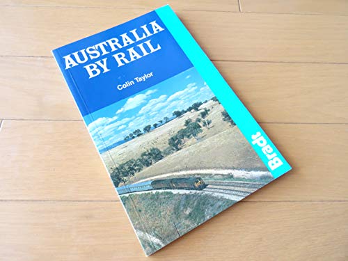
AUSTRALIA BY RAIL
Language: English
Published by Bradt Publications, England, 1988
ISBN 10: 0946983283 ISBN 13: 9780946983285
Seller: COOK AND BAKERS BOOKS, PARKSVILLE, VANCOUVER ISLAND, BC, Canada
Seller rating 5 out of 5 stars
First Edition
Soft cover. Condition: Very Good. Black & White Photographs & Map (illustrator). First Edition. Cover has light shelfwear, otherwise without flaw, 5 X 8" 141 pages. From 1988. The railways of Australia can take you from the heart of major cities to remote parts of the outback, without fuss, without the fatigue of driving and with much greater safety than you will find on the roads, plus, they are air-conditioned. You will learn how to make the most of your Austrail Pass with 25 scenic rail trips, intercity and interstate train routes and 101 destinations. Illustrated with black-and-white photographs and maps.
-
GLIMPSES OF AUSTRALIA AUGUST-SEPTEMBER, 1908
Published by William Applegate Gullick, Sydney, 1908
Seller: Riverow Bookshop, Owego, NY, U.S.A.
Seller rating 5 out of 5 stars
Cloth. Condition: Reading copy/No Dustjacket. Photographs and Map (illustrator). Sydney: William Applegate Gullick. Reading copy/No Dustjacket. 1908. . Cloth. Souvenir for the United States Navy, published by the Government Printer for the State of New South Wales. . oblong 16mo., unpaginated, cover pulling loose, taped at front e/p & t/p; ex-library copy with blind stamp .
-

The Cities of Australia (Outward Bound Library)
Language: English
Published by J.M. Dent & co., London, 1928
Seller: Dorley House Books, Inc., Hagerstown, MD, U.S.A.
Seller rating 4 out of 5 stars
First Edition
Hardcover. Condition: Very Good. No Jacket. d'Auvergne Boxall; Map endpapers and black and white illustrations (illustrator). 1st Edition. No date given (Circa 1928?); blue c w/gilt spine titles; some shelf rubbing, lite wear at extremities; lite toning of end papers; 204 clena, unmarked pages.
-

MAP: 'South Australia'.map from Encyclopaedia Britannica, Ninth Editon
Published by Encyclopaedia Britannica, London, 1911
Seller: Dorley House Books, Inc., Hagerstown, MD, U.S.A.
Seller rating 4 out of 5 stars
Art / Print / Poster First Edition
Map. Condition: Very Good. Handcolored Map (illustrator). 1st. handcolored map--LOVELY!.and suitable for framing Size: 10.5 x 15.".
-
Journey Across The Western Interior of Australia by Colonel Peter Egerton Warburton with an introduction and additions by Charles H. Eden edited by H.W. Bates with illustrations and a map Facsimile Edition
Language: English
Published by Hesperian Press, Victoria Park, 1981
ISBN 10: 0859050319 ISBN 13: 9780859050319
paperback. Condition: Good. fold-out map/b&w illustrations (illustrator). Facsimile edition of Warburton's Journey Across The Western Interior of Australia, with an introduction and additions by Charles H. Eden, edited by H.W. Bates, first published in 1875; 10 b&w illustrations; fold-out map to rear showing Warburton's Route; medium foxing to endpapers, prelims, and text block, o.w. Very Good throughout; wraps lightly rubbed and with one or two reading creases. . 307pp. 8vo. Good.
-
The Red Centre man and beast in the heart of Australia Australiana Facsimile Editions No. 206
Language: English
Published by Libraries Board of South Australia, Adelaide, 1979
ISBN 10: 072430066X ISBN 13: 9780724300662
hardbound. Condition: Good. b&w illustrations/fold-out map (illustrator). Libraries Board of South Australia Australiana Facsimile Editions No. 206; facsimile reprint of Finlayson's The Red Centre (first published Angus & Robertson Sydney 1935); with a foreword by Frederick Wood Jones; b&w illustrations throughout; fold-out map to rear of text; endpapers and text block foxed, occasional foxing in text, o.w. Good no dustwrapper. 146pp. 8vo. Good.
-
OUTBACK IN AUSTRALIA OR THREE AUSTRALIAN OVERLANDERS . including various phases of Outback life
Published by Garden City Press, Letchworth, 1919
Seller: Riverow Bookshop, Owego, NY, U.S.A.
Seller rating 5 out of 5 stars
Cloth. Condition: Good condition/No Dustjacket. Photographs and map (illustrator). 3rd. edition. Letchworth: Garden City Press. Good condition/No Dustjacket. 1919. 3rd. edition. Cloth. With 30 illustrations and a color map pasted to the inside of back cover. . 8vo., x, 224 pp., Rear cover and several back pages water-damaged, spine faded, hinges weak, cracked; blind stamp .
-

Condition: Very Good. Colour Map from The Times Survey Atlas Of The World. Measures approx 22 3/4 x 17 1/2 inches. Centre fold. With inset map of Adelaide.
-
Condition: Very Good. Colour Map from The Times Atlas. Measures approx 16 x 22 inches. Centre fold.
-

Condition: Very Good. Colour Map from The Harmsworth Atlas and Gazetteer, circa 1910. Measures approx 15 1/2 x 20 inches.
-

Condition: Very Good+. Colour map measures approx 22 3/4 x 17 3/4 inches (including margins). Centre fold. With inset map of Adelaide. From The Times Survey Atlas of The World. Prepared under the direction of J. G. Bartholomew.
-

Condition: Very Good+. Colour map measures approx 22 3/4 x 17 3/4 inches (including margins). Centre fold. With inset map of Tasmania. From The Times Survey Atlas of The World. Prepared under the direction of J. G. Bartholomew.
-

Condition: Very Good. Colour Map from The Times Survey Atlas Of The World. Measures approx 17 1/2 x 22 3/4 inches. Centre fold. With inset maps of Prevailing Vegetation, January & July Rainfall, & Density of Population.
-

Condition: Very Good. Colour Map from The Times Survey Atlas Of The World. Measures approx 22 3/4 x 17 1/2 inches. Centre fold.
-
Condition: Very Good. Colour Map from Philips' International Atlas. Measures approx 20 1/2 x 15 3/4 inches. Centre fold. With an inset map of Perth.
-

Condition: Very Good. Colour Map from The Harmsworth Atlas and Gazetteer, circa 1910. Measures approx 15 1/2 x 20 inches.
-

Condition: Very Good. Colour Map from The Harmsworth Atlas and Gazetteer, circa 1910. Measures approx 15 1/2 x 20 inches. With inset maps of Port Adelaide, Port Phillip & Port Jackson.
-

Condition: Very Good. Colour Map from Harmsworth's New Atlas. Undated, circa 1920s. With an inset maps of Adelaide, & printed information & illustrations on the back. Measures approx 14 1/2 x 9 3/4 inches. With small pin holes on one edge, otherwise clean & bright.
-

Condition: Very Good. Colour Map from Harmsworth's New Atlas. Undated, circa 1920s. With printed information & illustrations on the back. Measures approx 14 1/2 x 9 3/4 inches. With small pin holes on one edge, otherwise clean & bright.
-

Australia: Federal Territory & Town Plans of Sydney, Brisbane, Melbourne & Canberra.
Published by The Amalgamated Press Ltd., London.
Map
Condition: Very Good. Colour Map from Harmsworth's New Atlas. Undated, circa 1920s. With printed information & illustrations on the back. Measures approx 9 3/4 x 14 1/2 inches. With small pin holes on one edge, otherwise clean & bright.
-

Condition: Very Good. Colour Map from Harmsworth's New Atlas. Undated, circa 1920s. With an inset map of Tasmania, & printed information & illustrations on the back. Measures approx 14 1/2 x 19 3/4 inches. With small pin holes on the centre fold, otherwise clean & bright.
-

Condition: Very Good+. Colour map measures approx 22 3/4 x 17 3/4 inches (including margins). Centre fold. With inset map of Brisbane. From The Times Survey Atlas of The World. Prepared under the direction of J. G. Bartholomew.
-
Condition: Very Good+. Colour map measures approx 22 3/4 x 17 3/4 inches (including margins). Centre fold. With inset maps of Perth & Albany. From The Times Survey Atlas of The World. Prepared under the direction of J. G. Bartholomew.
-
AUSTRALIA, AN ANTIQUE MAP, CIRCA 1860
Language: English
Published by GEORGE VIRTUE, Edinburgh, 1837
Seller: K Books Ltd ABA ILAB, York, YORKS, United Kingdom
Association Member: ABA ILAB PBFA
Seller rating 5 out of 5 stars
First Edition
US$ 17.82
US$ 26.14 shipping
Ships from United Kingdom to U.S.A.Quantity: 1 available
Add to basketSingle Sheet Engraving. Condition: Very Good. No Jacket. J DOWER (illustrator). First Edition. AUSTRALIA, AN ANTIQUE MAP, CIRCA 1860 A VERY GOOD MAP . VERY REASONABLY PRICED, . MEASURES 10 X 8 INCHES, 30 X 22 CMS, WELL PACKED MOUNTED AND READY TO FRAME, SEEMS VERY FEW TOWNS MENTIONED OTHE THAN ROUND THE COAST, VERY GOOD CONDITION, SPLENDID VALUE.
-

Condition: very good. Gut/Very good: Buch bzw. Schutzumschlag mit wenigen Gebrauchsspuren an Einband, Schutzumschlag oder Seiten. / Describes a book or dust jacket that does show some signs of wear on either the binding, dust jacket or pages.
-
MAP: 'Australia'.from Atlas of the World
Published by Rand McNally & Co, NY, 1895
Seller: Dorley House Books, Inc., Hagerstown, MD, U.S.A.
Seller rating 4 out of 5 stars
Art / Print / Poster
Unbound. Condition: Very Good. Handcolored Map (illustrator). map of Queensland & New South Wales & Victoria, and part of South Australia. very nice, and suitable for framing; center fold reinforced with archival tape on reverse Size: 22" x 14".
-
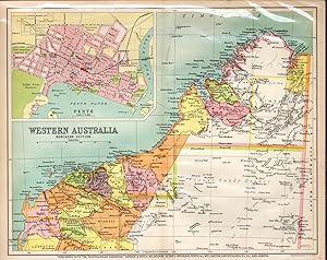
MAP: 'Western South Australia'.from the Australian Handbook, 1906
Published by Gordon & Gotch, Australia, 1906
Seller: Dorley House Books, Inc., Hagerstown, MD, U.S.A.
Seller rating 4 out of 5 stars
Art / Print / Poster First Edition
Unbound. Condition: Very Good. Colored Map (illustrator). 1st. Lovely little map showing the northern section of Western Australia of 1906 with a 3.5 x 5' inset of Perth.Single sheet suitable for framing Size: 9.5" x 11.75".


