Boston Vicinity by Johnson (3 results)
 More images
Published by A.J.Johnson New York 1870
- Map
Seller: Angelika C. J. Friebe Ltd. - MapWoman, Dorking, United KingdomAngelika C. J. Friebe Ltd. - MapWoman
Contact seller5-star sellerCondition: Used - Very good
US$ 203.94
US$ 26.40 shippingShips from United Kingdom to U.S.A.Quantity: 1 available
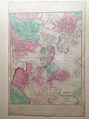
No Binding. Condition: Very Good. colour printed map; overall 69 x 46 cm; fold as issued; some faint foxing and soiling; some very minor marginal tears not affecting image; o/w vg cond. A very detailed map of Boston and its vicinity. ex: Johnson's New Illustrated Family Atlas of the World.

Seller: Art Source International Inc., Boulder, CO, U.S.A.Art Source International Inc.
Contact seller5-star sellerThis map was issued as part of "Johnson's New Illustrated Family Atlas of the World." This atlas was awarded the first prize medal at the Universal Expositions in Paris in 1867 and 1878. A.J. Johnson published his first atlas in 1860 as successors to J.H. Colton & Co. Editions of this atlas ceased in 1885. These later editions o…f the Johnson atlas are some of the finest the company ever produced and are known for the geometric border. This map measures 17 inches by 23 inches.

Seller: Art Source International Inc., Boulder, CO, U.S.A.Art Source International Inc.
Contact seller5-star sellerThis 1883 map by A.J. Johnson shows Boston. This map names railroads, city car routes, ward boundaries, islands, harbor comm. lines, and more. This series of maps are very unique in that they're the latest we've seen, in over 30 years of collecting, by famed cartographer A.J. Johnson. An enthralling and informative find! This ma…p measures 15 inches by 17 inches.


