Cologne by Fer (13 results)

Published by dans l'Isle du Palais à la Sphere royalle o.J. (1705), Paris, 1705
- Map
Seller: Versandantiquariat Hösl, Neuried, GermanyVersandantiquariat Hösl
Contact seller5-star sellerCondition: Used - Very good
US$ 56.55
US$ 10.87 shippingShips from Germany to U.S.A.Quantity: 1 available
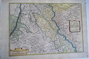
Condition: Gut. Grenzkolorierte Kupferstichkarte im Maßstab ca. 1:320000 des Gebiets zwischen Rhein und Maas mit den rechtsrheinischen Gebieten des heutigen Ruhrgebiets bis südlich nach Köln. Lt: Kartusche: Le Bas Electorat de Cologne, Partie des Duchez de Iuliers de Berg, et de Gueldres et le Comte de Meurs. Nicolas de Fer (* 1…646; ? 25. Oktober 1720 in Paris) war einer der führenden französischen Kartographen und Kartenverleger des ausgehenden 17. und beginnenden 18. Jahrhunderts. Blatt mit Knitterspuren und kleinen Randläsuren am oberen linken Eck, sonst mit den üblichen altersbedingten kleinen Verdunklungen/Braunflecken; schwacher Flüssigkeitsfleck am linken Rand der Karte. Die Rückseite ist leer. Sprache / Language: fr 1 Seiten. ca. 28,3 x 40 cm.

Language: French
Published by Paris, 1697
- Art / Print / Poster
Seller: Antiquariat Steffen Völkel GmbH, Seubersdorf, GermanyAntiquariat Steffen Völkel GmbH
Contact seller5-star sellerCondition: Used
US$ 58.90
US$ 34.32 shippingShips from Germany to U.S.A.Quantity: 1 available
Original Kupferstich von 1697. -- Blatt-Maße: ca. 29 x 37 cm. -- leicht fleckig - sonst gut erhalten. || Original engraving from 1697. // Wir, das Antiquariat Steffen Völkel, kaufen und verkaufen alte Bücher, Handschriften, Zeichnungen, Autographen, Grafiken und Fotografien. Wir sind stets am Ankauf von kompletten Bibliotheken,…Sammlungen und Nachlässen interessiert. Sprache: Französisch Gewicht in Gramm: 1550.

Le cours du Rhein depuis Cologne, jusques a Rheinberg : ou se trouvent le bas electorat de Cologne, partie des duchez de Iuliers, de Berg, et de Gueldres et le comté de Meurs . Par N. de Fer . First edition of the map .
Fer, Nicolas de (1646 - 1720); Pieter Starckman (fl. c. 1680 - 1730), a.k.a Peter or Petrus, engraver
Published by Paris: chez l'auteur dans l'Isle du Palais sur le quay de l'orloge a la Sphére Royale avec privilége du Roy-1717, 1705
- Art / Print / Poster
Seller: Wittenborn Art Books, San Francisco, CA, U.S.A.Wittenborn Art Books
Contact seller5-star sellerCondition: Used - Good
US$ 150.00
US$ 10.00 shippingShips within U.S.A.Quantity: 1 available
Condition: Good. Engraved map. 27.3 x 38 cm. Contemporary laid paper uniformly time aged.Published in "L'atlas curieux ou Le monde répresénté dans des cartes générales et particulieres du ciel et de la terre, : divisé tant en ses quatre principales parties que par états et provinces et orné par des plans et descriptions des vill…es capitales et principales et des plus superbes edifices qui les embelissent comme sont les eglises, les palais, les maisons de plaisance, les iardins, les fontaines &c. ". OCLC Number / Unique Identifier:79022119.LThe Atlas Curieux is geographic encyclopedia of images and maps of France, with detailed views of the grand waterworks at Marly, views of the great palaces and chateaux, views and plans of the Paris Observatory, and samples of military architecture. Issued in six annual parts from 1700-1705, the maps are based on the new observations of the Académie des Sciences, and drawn up with the assistance of Philipe de La Hire.ibrary of Congress:The French cartographer and engraver, Nicolas de Fer, was a master at creating maps that were works of art. The maps that he published were printed during the Baroque period when the decorative arts were characterized by ornate detail. De Fer's detailed maps and atlases were valued more for their decorative content than their geographical accuracy.Nicolas de Fer was born in 1646. His father, Antoine de Fer, owned a mapmaking firm. At the age of twelve, Nicolas was apprenticed to a Parisian engraver named Louis Spirinx. The family business was starting to decline when his father died in 1673. Nicolas de Fer's mother, Genevieve, took over the business after the death of her husband. In 1687 the business was passed on to Nicolas and the profits increased after he took over the firm. Nicolas de Fer was a prolific cartographer who produced atlases and hundreds of single maps. He eventually became the official geographer to King Louis XIV of France and King Philip V of Spain.One of de Fer's major works is an atlas titled L'atlas curieux (The curious atlas).

Le Cours Du Rhein, depuis Coblens Jusques a Cologne : ou se trouvent partie des Archevêchez et Electorats de Treves, et de Cologne, et partie des Duchez de Juliers et de Berg . Par N. de Fer . First edition of the map .
Fer, Nicolas de (1646 - 1720); Pieter Starckman (fl. c. 1680 - 1730), a.k.a Peter or Petrus, engraver
Published by Paris: chez l'auteur dans l'Isle du Palais sur le quay de l'orloge a la Sphére Royale avec privilége du Roy-1717, 1705
- Art / Print / Poster
Seller: Wittenborn Art Books, San Francisco, CA, U.S.A.Wittenborn Art Books
Contact seller5-star sellerCondition: Used - Good
US$ 150.00
US$ 10.00 shippingShips within U.S.A.Quantity: 1 available
Condition: Good. Engraved map. 27.3 x 38 cm. Contemporary laid paper uniformly time aged.Published in "L'atlas curieux ou Le monde répresénté dans des cartes générales et particulieres du ciel et de la terre, : divisé tant en ses quatre principales parties que par états et provinces et orné par des plans et descriptions des vill…es capitales et principales et des plus superbes edifices qui les embelissent comme sont les eglises, les palais, les maisons de plaisance, les iardins, les fontaines &c. ". OCLC Number / Unique Identifier:79022119.LThe Atlas Curieux is geographic encyclopedia of images and maps of France, with detailed views of the grand waterworks at Marly, views of the great palaces and chateaux, views and plans of the Paris Observatory, and samples of military architecture. Issued in six annual parts from 1700-1705, the maps are based on the new observations of the Académie des Sciences, and drawn up with the assistance of Philipe de La Hire.ibrary of Congress:The French cartographer and engraver, Nicolas de Fer, was a master at creating maps that were works of art. The maps that he published were printed during the Baroque period when the decorative arts were characterized by ornate detail. De Fer's detailed maps and atlases were valued more for their decorative content than their geographical accuracy.Nicolas de Fer was born in 1646. His father, Antoine de Fer, owned a mapmaking firm. At the age of twelve, Nicolas was apprenticed to a Parisian engraver named Louis Spirinx. The family business was starting to decline when his father died in 1673. Nicolas de Fer's mother, Genevieve, took over the business after the death of her husband. In 1687 the business was passed on to Nicolas and the profits increased after he took over the firm. Nicolas de Fer was a prolific cartographer who produced atlases and hundreds of single maps. He eventually became the official geographer to King Louis XIV of France and King Philip V of Spain.One of de Fer's major works is an atlas titled L'atlas curieux (The curious atlas).

Published by Parigi, 1702
- Map
Seller: Libreria Ex Libris ALAI-ILAB/LILA member, Roma, RM, ItalyLibreria Ex Libris ALAI-ILAB/LILA member
Contact seller5-star sellerCondition: Used
US$ 176.72
US$ 34.32 shippingShips from Italy to U.S.A.Quantity: 1 available
Incisione originale su rame (cm. 35x23 più ampi margini bianchi) tratta da 'L'Atlas curieux ou Le Monde representé dans des cartes generales et particulieres du ciel et de la terre'. Esemplare in ottimo stato di conservazione. Non comune. La carta è accompagnata da un foglio descrittivo proveniente dal medesimo Atlante.

Published by N. de Fer, Paris, 1702
- Map
Seller: Antiquariat Reinhold Berg eK Inh. R.Berg, Regensburg, GermanyAntiquariat Reinhold Berg eK Inh. R.Berg
Contact seller5-star sellerCondition: Used
US$ 206.18
US$ 27.45 shippingShips from Germany to U.S.A.Quantity: 1 available
Other. Hand-Colored Original Copperplate Engraving by Nicolaus de Fer, depicting Cologne. Published Paris, N. de Fer, 1702. Sheet: 232 by 349mm (9 by 13 inches). A fine and original hand-colored example of de Fer's celebrated cartographic work, documenting this region of Germany with the precision and decorative artistry charact…eristic of the 17000s. Nicolaus de Fer was a cartographer active in the 1700s, working in the tradition of European copper-engraved cartography. Their maps are valued by collectors for their historical accuracy and decorative quality.This original copperplate engraving, with original hand coloring depicts the region of Cologne, published in Paris, N. de Fer, 1702. The map records the political and geographic boundaries of the region as understood in 1702, offering a fascinating window into the history of German territorial organization. Sheet measures 232 by 349mm (9 by 13 inches). In excellent condition. Ready to frame. One old crease in the paper, else in very good condition. 232 by 349mm (9 by 13 inches). 232 by 349mm (9 by 13 inches).

Published by Paris Chez L'Auteur dans L'Isle du Palais a la Sphere Royal Avec Priv du Roy, 1702
- Art / Print / Poster
Seller: Neusser Buch & Kunst Antiquariat, Neuss, NRW, GermanyNeusser Buch & Kunst Antiquariat
Contact seller4-star sellerCondition: Used
US$ 148.45
US$ 85.79 shippingShips from Germany to U.S.A.Quantity: 1 available
Kupferstich, Darstellung: 23 x 33. Blatt: 26,5 x 38,5 gut erhalten. Auf Wunsch Digitalaufnahme in jpg-Format erhältlich- photo in jpg-format available. Je nach Versandart können die Portokosten bis zu 2 weniger als angegeben betragen. Links unten Meilenanzeiger, rechts in der Mitte Kartusche mit Titel. Zeigt den Rheinlauf von Kö…ln bis Rheinberg, den nördlichen Teilen des Erzbistums Köln, die Herzogtümer Jülich und Berg, Die Grafschaft Meurs und Geldern. Nreuss und Düsseldorf ca. in der Mitte der Karte. Sprache: Deutschu.

Published by Atlas Curieux ou le Monde. Paris 1717, 1717
Seller: Peter Harrington. ABA/ ILAB., London, United KingdomPeter Harrington. ABA/ ILAB.
Contact seller5-star sellerCondition: Used
US$ 277.08
US$ 29.59 shippingShips from United Kingdom to U.S.A.Quantity: 1 available
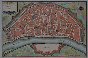
Plan of Cologne, with north to the right, showing fortifications and old town. Title at top left. Includes accompanying text Copper engraving. Excellent condition, good margins. Uncoloured. Size: 34.8 x 24 cm. (13½ x 9½ inches).

Description de la Ville de Cologne [and] Cologne Ville Considerable Située Sur le bord Occidental du Rhein Capit. de L'Electorate de meme nom. Par N. de Fer. First edition of the map and text.
Fer, Nicolas de (1646 - 1720); Pieter Starckman (fl. c. 1680 - 1730), a.k.a Peter or Petrus, engraver
Published by Paris: chez l'auteur dans l'Isle du Palais sur le quay de l'orloge a la Sphére Royale avec privilége du Roy-1717, 1705
- Art / Print / Poster
Seller: Wittenborn Art Books, San Francisco, CA, U.S.A.Wittenborn Art Books
Contact seller5-star sellerCondition: Used - Good
US$ 300.00
US$ 10.00 shippingShips within U.S.A.Quantity: 1 available
Condition: Good. Engraved text broadside and engraved map.Each 27.3 x 38cm. Contemporary laid paper uniformly time aged.Published in "L'atlas curieux ou le monde répresénté dans des cartes générales et particulieres du ciel et de la terre, : divisé tant en ses quatre principales parties que par états et provinces et orné par des… plans et descriptions des villes capitales et principales et des plus superbes edifices qui les embelissent comme sont les eglises, les palais, les maisons de plaisance, les iardins, les fontaines &c. ". OCLC Number / Unique Identifier:79022119.LThe Atlas Curieux is geographic encyclopedia of images and maps of France, with detailed views of the grand waterworks at Marly, views of the great palaces and chateaux, views and plans of the Paris Observatory, and samples of military architecture. Issued in six annual parts from 1700-1705, the maps are based on the new observations of the Académie des Sciences, and drawn up with the assistance of Philipe de La Hire.ibrary of Congress:The French cartographer and engraver, Nicolas de Fer, was a master at creating maps that were works of art. The maps that he published were printed during the Baroque period when the decorative arts were characterized by ornate detail. De Fer's detailed maps and atlases were valued more for their decorative content than their geographical accuracy.Nicolas de Fer was born in 1646. His father, Antoine de Fer, owned a mapmaking firm. At the age of twelve, Nicolas was apprenticed to a Parisian engraver named Louis Spirinx. The family business was starting to decline when his father died in 1673. Nicolas de Fer's mother, Genevieve, took over the business after the death of her husband. In 1687 the business was passed on to Nicolas and the profits increased after he took over the firm. Nicolas de Fer was a prolific cartographer who produced atlases and hundreds of single maps. He eventually became the official geographer to King Louis XIV of France and King Philip V of Spain.One of de Fer's major works is an atlas titled L'atlas curieux (The curious atlas).

Published by Paris, 1705
- Map
Seller: Alexandre Antique Prints, Maps & Books, Toronto, ON, CanadaAlexandre Antique Prints, Maps & Books
Contact seller4-star sellerCondition: Used - Very good
US$ 475.00
US$ 6.00 shippingShips from Canada to U.S.A.Quantity: 1 available
Condition: Very Good. Copper engraved plan of Cologne (Köln) in Germany. It is beautifully hand coloured. , Size : 235x350 (mm), 9.25x13.75 (Inches), Hand Colored.
Seller: Treptower Buecherkabinett Inh. Schultz Volha, Berlin, GermanyTreptower Buecherkabinett Inh. Schultz Volha
Contact seller5-star sellerCondition: Used
US$ 77.76
US$ 53.76 shippingShips from Germany to U.S.A.Quantity: 1 available
Blattgröße ca. 27 x 38,5 cm. - Rechter Außenrand mit Bindungslöchlein. Etwas gebräunt. C2-F Sprache: Deutsch Gewicht in Gramm: 2000.

- Map
Seller: Geographicus Rare Antique Maps, Brooklyn, NY, U.S.A.Geographicus Rare Antique Maps
Contact seller4-star sellerVery good. Original platemark visible. Blank on verso. Minor overall toning. Size 9.5 x 14 Inches. This is a beautiful 1705 Nicholas de Fer map of the walled city of Cologne, Germany. Oriented with North to the right, this map identifies the location of the city on the banks of the Rhine River. Originally the capital city of the… Roman province Germania Inferior, Cologne was established in 50 AD. The medieval city wall surrounding the city was built in 1180 and enclosed the Free Imperial City for 600 years. Of the original 12 city gates, only Eigelsteintorburg, Hahnentorburg, Severinstorburg and Ulrepforte remain to this day. The remains of Bayen, the medieval tower and the city wall at Gereonswall can also been seen today. This map identifies various streets, churches and other notes other topographical details throughout. This map created by Nicholas de Fer in 1705.
 More images
Language: German
- Art / Print / Poster
Seller: Kunstantiquariat Andreas Senger, Hamburg, GermanyKunstantiquariat Andreas Senger
Contact seller5-star sellerCondition: Used - Fine
US$ 293.36
US$ 40.03 shippingShips from Germany to U.S.A.Quantity: 1 available
Kein Einband. Condition: Sehr gut. Es handelt sich hierbei um einen originalen, kolorierten Kupferstichplan der Stadt Köln von Nicholas de Fer aus dem Jahr 1702. *** Titel: Cologne Ville Considerable Situee sur le bord Occidentale du Rhein Capit. de l'Electorat de meme nom. Par N. de Fer *** Gebiet bzw. Ort: Köln *** Kartograph:… Nicholas de Fer (1647 - 1720) *** Jahr: 1702 *** Größe des Abbildungsbereichs: 23 x 35 cm *** Technik: Kupferstich *** Zustand (Perfekt/ Sehr gut/ Gut/ Ordentlich/ Mäßig/ Schlecht): In sehr gutem Erhaltungszustand *** Bemerkungen: Schöner Plan von Köln aus der Vogelschau in dekorativem Kolorit. - - - International buyers welcome. If you have any questions, please don't hesitate to ask. --- Auf Wunsch stellen wir Ihnen gerne ein kostenfreies Echtheitszertifikat aus --- If you wish, we will gladly provide a certificate of authenticity free of charge ---.


