Order Total (1 Item Items):
Shipping Destination:

Derbyshire by Walker (8 results)
Skip to main search results
Search filters
Product Type
- All Product Types
- Books (5)
- Magazines & Periodicals (No further results match this refinement)
- Comics (No further results match this refinement)
- Sheet Music (No further results match this refinement)
- Art, Prints & Posters (No further results match this refinement)
- Photographs (No further results match this refinement)
- Maps (3)
- Manuscripts & Paper Collectibles (No further results match this refinement)
Condition Learn more
- New (No further results match this refinement)
- As New, Fine or Near Fine (No further results match this refinement)
- Very Good or Good (5)
- Fair or Poor (No further results match this refinement)
- As Described (3)
Binding
Collectible Attributes
- First Edition (2)
- Signed (1)
- Dust Jacket (No further results match this refinement)
- Seller-Supplied Images (5)
- Not Print on Demand (8)
Language (2)
Free Shipping
- Free Shipping to U.S.A. (No further results match this refinement)
Seller Location
Seller Rating
-

Bitter End (Derbyshire Detective Inspector Diane Rothwell)
Book 1 of 5: Derbyshire Detective Inspector Diane RothwellUS$ 13.20
US$ 21.16 shipping
Ships from United Kingdom to U.S.A.Quantity: 1 available
Add to basketPaperback. Condition: Used; Good. ***Simply Brit*** Welcome to our online used book store, where affordability meets great quality. Dive into a world of captivating reads without breaking the bank. We take pride in offering a wide selection of used books, from classics to hidden gems, ensuring there is something for every literary palate. All orders are shipped within 24 hours and our lightning fast-delivery within 48 hours coupled with our prompt customer service ensures a smooth journey from ordering to delivery. Discover the joy of reading with us, your trusted source for affordable books that do not compromise on quality.
-

FOLKTALES AND LEGENDS OF DERBYSHIRE
Published by Minimax Books, GB, 1982
Seller: Richard Sylvanus Williams (Est 1976), WINTERTON, United Kingdom
Seller rating 5 out of 5 stars

First Edition
US$ 11.38
US$ 42.34 shipping
Ships from United Kingdom to U.S.A.Quantity: 1 available
Add to basketPaperback. Condition: VG+. 1st Edition. A5. 64 pages. Book is in very good plus condition with very minor signs of wear and/or age.
-

Single sheet. Fine original hand colouring of the hundreds and the county boundaries. Offered at reduced price because the item shows some foxing. (See image). Note: This map shows some newly opened railway lines. (Midland Counties Railroad, the Birmingham and Derby Railroad and the North Midland Railroad) 32 x 39 cm.
-
Eastern England - Derbyshire, Cambridgeshire, Northamptonshire Etc - an Antique Map
Language: English
Seller: K Books Ltd ABA ILAB, York, YORKS, United Kingdom
Association Member: ABA ILAB PBFA
Seller rating 5 out of 5 stars
US$ 40.88
US$ 25.80 shipping
Ships from United Kingdom to U.S.A.Quantity: 1 available
Add to basketNo Binding. Condition: Very Good. Engraved By Walker (illustrator). A fine antique map in very good condition - printed in circa 1844. Mounted (matted) and ready to frame. Coloured in outline, hand colouring contemporary. Engraved size approx 16 x 13 Ins, 41 x 33 Cms. Mounted size approx 19 x 16 in, 49 x 41cm. A fine opportunity to purchase an attractive and decorative engraved antique map of Eastern England - Derbyshire, Cambridgeshire, Northamptonshire Etc.
-

England III. Lincolnshire, Nottinghamshire, Derbyshire, Leicestershire, Warwickshire, Northhamptonshire, Huntingdonshire, Northfolk, Suffolk und Cambridgeshire. Antique Map. Grenzkolorierter Original-Stahlstich von Walker bei Baldwin & Cradock 1830
Published by London: Baldwin & Cradock, 1830
Seller: historicArt Antiquariat & Kunsthandlung, Wiesbaden-Breckenheim, Germany
Seller rating 5 out of 5 stars
Map First Edition Signed
1. Original-Stahlstich von J. & C. Walker (in der Platte signiert) auf rückseitig unbedrucktem Blatt, von alter Hand grenzkoloriert, bildliche Darstellung ca. 27 x 36 cm, Blattgröße ca. 35 x 41 cm, sauber und sehr gut erhalten 2100 gr.
-

Derbyshire.
Published by London, Longman, Hurst, Rees, Orme, & Co., 1835-. 395 x 325mm (15½ x 12¾ inches)., 1835
Seller: Tooley, Adams & Co., Wallingford, OXON, United Kingdom
Seller rating 3 out of 5 stars

US$ 43.61
US$ 49.15 shipping
Ships from United Kingdom to U.S.A.Quantity: 1 available
Add to basketOriginal colour lithograph; fine condition. A detailed map of the county. Shows the places of the meeting of foxhounds and the areas are marked. From Hobson's Fox Hunting Atlas.
-
Map of the Yorkshire, Derbyshire &Nottinghamshire Coalfield showing its probable extension into Lincolnshire.
Published by G.W Bacon, London
Seller: Morgan The Maps, Aldgate, Adelaide Hills, SA, Australia
Seller rating 4 out of 5 stars

Map
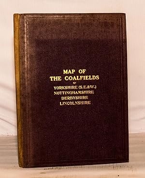
Hardcover. Condition: Good. This is a large folding map, measuring 145 x 102 cms and dissected into 32 linen backed segments, concertina folding into maroon cloth covered boards measuring 18.5 X 26 cms. The map is in good condition, clean and bright with sturdy folds. The boards, however, are unevenly faded as the photo shows, though the gilt lettering stands out clearly. The boards are firmly attached, though the boards and block have some lateral movement when the map is folded. The cloth of the boards is also starting to fray where they attach to the spine. The map is undated but, the numbers of mines indicated would suggest it to be from around the time of the First World War. The extent of the Yorkshire, Derbyshire and Nottinghamshire coalfields is well known at this time and marked as such, but much of the information on any extension into Lincolnshire is still being estimated, as the geological comment on the map indicates. This map is one of a limited edition of 500 copies. Please note that this item is located in Australia and additional postage (to that calculated by Abe Books) may be required if it is being posted internationally. Please contact beforehand if you need to know the exact cost.
-
Map of the Yorkshire, Derbyshire & Nottinghamshire Coalfield Showing Its Probable Extension Into Lincolnshire
Published by G. W. Bacon & Co.
Seller: Kerr & Sons Booksellers ABA, Cartmel, CMA, United Kingdom
Seller rating 5 out of 5 stars
US$ 340.71
US$ 39.69 shipping
Ships from United Kingdom to U.S.A.Quantity: 1 available
Add to basketHardcover. Condition: Very Good. Limited Edition. Limited edition of 500 copies. No Date. Early Twentieth Century. Linen backed 32 section folding map measuring 102cm x 143cm (40"x56.5"). Scale: 2 miles to an inch. Coloured with marked limit lines and locations of collieries. With a general section showing the seams of coal from the region. Former owners signature to top right corner. Otherwise clean and bright. Housed in maroon cloth boards with gilt title to front, fading to spine and board edges. Slight rubbing and bumping to extremities. Marbled end papers. Overall a Very Good copy. Scarce.