Order Total (1 Item Items):
Shipping Destination:

Devonshire by Moule Thomas (6 results)
Skip to main search results
Search filters
Product Type
- All Product Types
- Books (No further results match this refinement)
- Magazines & Periodicals (No further results match this refinement)
- Comics (No further results match this refinement)
- Sheet Music (No further results match this refinement)
- Art, Prints & Posters (No further results match this refinement)
- Photographs (No further results match this refinement)
- Maps (6)
- Manuscripts & Paper Collectibles (No further results match this refinement)
Condition Learn more
- New (No further results match this refinement)
- As New, Fine or Near Fine (No further results match this refinement)
- Very Good or Good (1)
- Fair or Poor (No further results match this refinement)
- As Described (5)
Binding
- All Bindings
- Hardcover (No further results match this refinement)
- Softcover (No further results match this refinement)
Collectible Attributes
- First Edition (No further results match this refinement)
- Signed (No further results match this refinement)
- Dust Jacket (No further results match this refinement)
- Seller-Supplied Images (6)
- Not Print on Demand (6)
Language (2)
Free Shipping
- Free Shipping to U.S.A. (No further results match this refinement)
Seller Location
Seller Rating
-
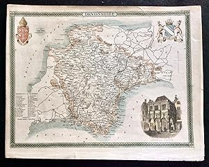
An antique engraved map of Devonshire, England
Language: English
Publication Date: 1830
Seller: GN Books and Prints, Inverness, United Kingdom
Seller rating 5 out of 5 stars

Map
US$ 18.56
US$ 25.65 shipping
Ships from United Kingdom to U.S.A.Quantity: 1 available
Add to basketNo Binding. Condition: As Described. No Jacket. Thomas Moule (illustrator). An antique engraved map of Devonshire, England, by Thomas Moule, from his "English Counties Delineated" circa 1830s-1840s. Contains three vignettes, comprising two coats of arms and an image of the Guildhall, Exeter, together with a Reference to the Hundreds. Measures around 10 3/4 x 8 1/2" (273mm x 215mm). The map contains no folds. There are signs of wear with a little tearing at top and a few binding piercing holes. Some foxing and toning, predominantly at edges, and some other marking but reasonably clean for age. Cropped a little close at right-hand margin. See pictures for further information. 1830s-1840s. n.
-

Single sheet. Decorative map with vignettes and coats of arms. Uncoloured as issued. Single original fold. Excellent margins. The Bristol railway has reached Plymouth. 28 x 22 cm.
-
ORIGINAL 19th CENTURY MAP OF DEVONSHIRE
Published by CIRCA 1830, 1830
Seller: Elder Books, Ross on Wye, Herefordshire, United Kingdom
Seller rating 5 out of 5 stars
Map
US$ 27.53
US$ 15.97 shipping
Ships from United Kingdom to U.S.A.Quantity: 1 available
Add to basketNo Binding. Condition: Very Good. AN ORIGINAL 19th CENTURY HAND COLOURED MAP OF DEVONSHIRE WITH BLANK REVERSE. MAP AREA WITHOUT MARGINS MEASURES APPROX 9.5 X 7.5 INCHES. FEW MINOR MARKS MOSTLY TO MARGINS, COUPLE OF MINOR TEARS AT MARGIN EDGES, FEW MINOR MARKS TO BLANK REVERSE OF MAP BUT OVERALL IN VERY GOOD CONDITION. EXTRA POSTAGE MAY APPLY FOR OVERSEAS ORDERS. ALL BOOKS ARE POSTED IN A STURDY BOOK BOX.
-

Devonshire.
Published by LondonGeorge Virtue 26 Ivy Lane Paternoster Row -1837., 1830
Seller: Robert Frew Ltd. ABA ILAB, London, United Kingdom
Association Member: ABA ILAB PBFA
Seller rating 5 out of 5 stars
Map
US$ 61.93
US$ 13.36 shipping
Ships from United Kingdom to U.S.A.Quantity: 1 available
Add to basketOriginal engraved map (27 x 21.5 cm). An attractive map of Devonshire with a vignette of the Guildhall in Exeter. With ornate border decorations.
-

Devonshire
Published by London, 1840
Seller: Clive A. Burden Ltd., Chalfont St. Giles, BUCKS, United Kingdom
Seller rating 5 out of 5 stars
Map
US$ 55.05
US$ 29.60 shipping
Ships from United Kingdom to U.S.A.Quantity: 1 available
Add to basketNo binding. 190 x 255 mm. Uncoloured. ex 'Barclay's Dictionary'. Moule (1784-1851) was a noted historian, map seller and publisher. His finest work is the 'English Counties Delineated' first published in 1837. The publisher was George Virtue who used the same beautiful plates in his publication of Rev. James Barclay's 'Dictionary'. The maps are considered the most attractive of all the later English county maps. Batten & Bennett 111.
-

1840 Original Antique Map of DEVONSHIRE DEVON by Thomas Moule (SM5-1)
Seller: Antique Paper Company, ASHFORD, KENT, United Kingdom
Seller rating 2 out of 5 stars

Map
1840 DEVONSHIRE A fine original antique map of DEVON by Thomas Moule with inset vignette view of GUILDHALL EXETER. Size approx 26.5cm x 20.5cm including margins. Condition is excellent.