
Order Total (1 Item Items):
Shipping Destination:

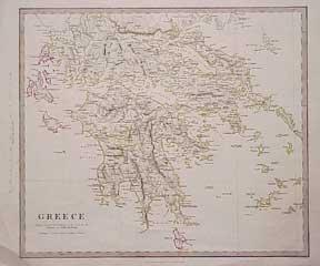
Greece Map by Walker (7 results)
Skip to main search results
Search filters
Product Type
- All Product Types
- Books (4)
- Magazines & Periodicals (No further results match this refinement)
- Comics (No further results match this refinement)
- Sheet Music (No further results match this refinement)
- Art, Prints & Posters (1)
- Photographs (No further results match this refinement)
- Maps (2)
- Manuscripts & Paper Collectibles (No further results match this refinement)
Condition Learn more
- New (No further results match this refinement)
- As New, Fine or Near Fine (2)
- Very Good or Good (5)
- Fair or Poor (No further results match this refinement)
- As Described (No further results match this refinement)
Binding
- All Bindings
- Hardcover (No further results match this refinement)
- Softcover (2)
Collectible Attributes
- First Edition (4)
- Signed (No further results match this refinement)
- Dust Jacket (No further results match this refinement)
- Seller-Supplied Images (5)
- Not Print on Demand (7)
Language (2)
Price
- Any Price
- Under US$ 25 (No further results match this refinement)
- US$ 25 to US$ 50
- Over US$ 50
Free Shipping
Seller Location
Seller Rating
-
Map of the Greece - disbound sheet from 1857 "University Atlas"
Published by Edward Stanford, London, 1857
First Edition
US$ 26.04
US$ 19.09 shipping
Ships from United Kingdom to U.S.A.Quantity: 1 available
Add to basketSoftcover. Condition: Good. Dust Jacket Condition: No Dust Jacket. First Edition. Disbound single Sheet Map with vertical centre fold from "The University Atlas of Classical and Modern Geography, including all the Recent Geographical Discoveries". Sheet is a little foxed with darkened edges. Some wear and minor damage to edges and corners with loss to the top left corner in the margin only. Fold is slightly split at both ends and a little fragile. Map does not cover the whole of what is now Greece but centres on Morea. Includes Gulfs of Arta, Patras, Aegina, Lepanto, Volo, Arkadia, Koroni, Kolokythi and Nauplia. Not all Islands are included but the following are present; Lefkada, Kefalonia, Zante, Kithira or Kerigo, Skyro or Skiros, Andros, Milos, etc. Sea coasts are coloured in very pale blue. Quantity Available: 1. Shipped Weight: under 1 kg. Pictures of this item not already displayed here available upon request. Inventory No: 45019044034. All our books are sent by tracked mail.
-
Map of the Turkish Empire with Greece - disbound sheet from 1857 "University Atlas"
Published by Edward Stanford, London, 1857
First Edition
US$ 28.20
US$ 19.09 shipping
Ships from United Kingdom to U.S.A.Quantity: 1 available
Add to basketSoftcover. Condition: Good. Dust Jacket Condition: No Dust Jacket. First Edition. Full title: "The Turkish Empire in Europe and Asia with the Kingdom of Greece". Disbound single Sheet Map with vertical centre fold from "The University Atlas of Classical and Modern Geography, including all the Recent Geographical Discoveries". Sheet is a little foxed with darkened edges. Some wear and minor damage to edges and corners. Fold is slightly split at both ends and a little fragile. Map includes Greece, Turkey, Crete, Cyprus, the Black Sea and parts of Russia (now Ukraine), Hungary (now Romania), Bulgaria, Moldova, Syria, Georgia, Africa, Arabia, Persia and the Mediterranean and Caspian Seas, etc. Sea coasts are coloured in pale blue. Quantity Available: 1. Shipped Weight: under 1 kg. Pictures of this item not already displayed here available upon request. Inventory No: 45019044033. All our books are sent by tracked mail.
-

Turkey, with North Part of Greece - an Antique Map
Language: English
Seller: K Books Ltd ABA ILAB, York, YORKS, United Kingdom
Association Member: ABA ILAB PBFA
Seller rating 5 out of 5 stars

US$ 47.46
US$ 25.67 shipping
Ships from United Kingdom to U.S.A.Quantity: 1 available
Add to basketNo Binding. Condition: Very Good. Engraved By Walker (illustrator). A fine antique map in very good condition - printed in circa 1844. Mounted (matted) and ready to frame. Engraved Size 14 x 10 Ins 35 x 25 cms. Mount size approx 17 x 13 ins, 43 x33 cms. Coloured in outline, hand colouring contemporary. A fine engraved map of Turkey, with North Part of Greece.
-
Greece Map.
Published by London: Society for the Diffusion of Useful Knowledge, [1844]., 1844
Seller: Wittenborn Art Books, San Francisco, CA, U.S.A.
Seller rating 4 out of 5 stars

Art / Print / Poster
Condition: Good. Map. Engraved. Hand-colored outlines. 14 x 17 inches. Printed by Charles Knight & Co.
-
Turkey, with Southern Part of Greece and Candia - with Vignette of Athens - an Antique Map
Language: English
Seller: K Books Ltd ABA ILAB, York, YORKS, United Kingdom
Association Member: ABA ILAB PBFA
Seller rating 5 out of 5 stars
US$ 61.02
US$ 25.67 shipping
Ships from United Kingdom to U.S.A.Quantity: 1 available
Add to basketNo Binding. Condition: Very Good. Engraved By Walker (illustrator). A fine antique map in very good condition - printed in circa 1844. Mounted (matted) and ready to frame. Engraved size approx 16 x 13 Ins, 41 x 33 Cms. Mounted size approx 19 x 16 in, 49 x 41cm. Coloured in outline, hand colouring contemporary. A fine engraved map of Turkey, with Southern Part of Greece and Candia - with Vignette of Athens.
-
1844 BEAUTIFUL Huge Color MAP of Greece Crete Acropolis of Athens Engraved ATLAS
Published by London : Published by the Society, and Chapman and Hall, 1844., 1844
Map First Edition
No Binding. Condition: Near Fine. 1st Edition. 1844 BEAUTIFUL Huge Color MAP of Greece Crete Acropolis of Athens Engraved ATLAS From "Society for Diffusion of Useful Knowledge" A beautifully hand-colored map from the 1844 printing of "Society for the Diffusion of Useful Knowledge" The Society for the Diffusion of Useful Knowledge (SDUK), founded in 1826, and wound up in 1848, was a Whiggish London organisation that published inexpensive texts intended to adapt scientific and similarly high-minded material for the rapidly expanding reading public. It was established mainly at the instigation of Lord Brougham with the objects of publishing information to people who were unable to obtain formal teaching, or who preferred self-education. Engraver: J & C Walker Atlas title: Maps of the Society for the Diffusion of Useful Knowledge. Map title: Turkey III. Kingdom of Greece, South, and Candia (includes engraving of the Acropolis of Athens) Published: London : Published by the Society, and Chapman and Hall, 1844. Language: English Notes & contents: Originally from the David Rumsey Collection FREE SHIPPING WORLDWIDE Wear: wear as seen in photos Publisher: London : Published by the Society, and Chapman and Hall, 1844. Size: ~13.5in X 16in (33cm x 41cm).
-
1844 BEAUTIFUL Huge Color MAP of Turkey Northern Greece Thessaloniki ATLAS
Published by London : Published by the Society, and Chapman and Hall, 1844., 1844
Map First Edition
No Binding. Condition: Near Fine. 1st Edition. 1844 BEAUTIFUL Huge Color MAP of Turkey Northern Greece Thessaloniki ATLAS From "Society for Diffusion of Useful Knowledge" A beautifully hand-colored map from the 1844 printing of "Society for the Diffusion of Useful Knowledge" The Society for the Diffusion of Useful Knowledge (SDUK), founded in 1826, and wound up in 1848, was a Whiggish London organisation that published inexpensive texts intended to adapt scientific and similarly high-minded material for the rapidly expanding reading public. It was established mainly at the instigation of Lord Brougham with the objects of publishing information to people who were unable to obtain formal teaching, or who preferred self-education. Engraver: J & C Walker Atlas title: Maps of the Society for the Diffusion of Useful Knowledge. Map title: Turkey II, South and Kingdom of Greece, North Published: London : Published by the Society, and Chapman and Hall, 1844. Language: English Notes & contents: Originally from the David Rumsey Collection FREE SHIPPING WORLDWIDE Wear: wear as seen in photos Publisher: London : Published by the Society, and Chapman and Hall, 1844. Size: ~13.5in X 16in (33cm x 41cm).


