Halma: Signed (14 results)

- Softcover
- Signed
Seller: GALERIE HIMMEL, Dresden, , GermanyGALERIE HIMMEL
Contact seller4-star sellerCondition: Used - Fine
US$ 47.08
US$ 36.57 shippingShips from Germany to U.S.A.Quantity: 1 available
Condition: sehr guter Zustand. Latendorf, Christiane. Halma.2020. Collage / Papiercollage, auf weißem Karton. Originale Künstlergrafik, von Christiane Latendorf. Unikat. 17,0 x 20,0 cm (Darstellung / Blatt).Sehr guter Zustand.Christiane Latendorf Christiane Latendorf (*1968 Anklam, lebt und arbeitet in Dresden). Deutsche Malerin… und Grafikerin. Lehre zur Apotheken-Facharbeiterin. 1988-91 Studium zur Pharmazie-Ingenieurin in Leipzig. Parallel dazu Abendstudium an der Hochschule für Grafik und Buchkunst Leipzig. 1992-97 Studium der Malerei und Grafik an der HfBK Dresden bei Ralf Kerbach. Bekanntschaft und künstlerischer Austausch mit Gerhard Kettner und Horst Leifer. Seit 1997 freischaffend als Malerin/Grafikerin tätig. Verso in Kugelschreiber und Bleistift signiert sowie datiert und betitelt.
- Signed
- Map
Seller: ThePrintsCollector, Zeeland, , NetherlandsThePrintsCollector
Contact seller5-star sellerCondition: Used
US$ 279.53
US$ 20.57 shippingShips from Netherlands to U.S.A.Quantity: 1 available
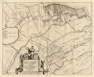
Map: Schooterlandt, de vijfde Grietenije van Zevenwolden - This regional map of the Schooterlandt Grietenij, part of the Province of Friesland, The Netherlands shows the situation around 1718. Grietenijen later turned into the present day towns. On this detailed map you will find: Oudeschoot, Rotstergaast, Nye Schoot, Nieuwescho…ot, Olde Schoot, Oudeschoot, Tjieuke Meer, Rottum, and much more detailed information. Copperplate engraving on verge type hand laid paper with watermark. Description: This detailed original antique map originates from: 'Uitbeelding der Heerlijkheit Friesland '', by B. Schotanus a Sterringa and published by F. Halma in 1718. This Atlas is considered the best atlas of Friesland, the Netherlands.Artists and Engravers: The author is Bernardus Schotanus a Sterringa (1640-1704). The publisher is Francois Halma (1653-1722). Some of the Grietenije kaarten in this work are signed by Jan and Gaspar Luyken / Luiken as the engravers. Condition: Fine. General age related toning and occasional light staining from handling as visible on image. Storage location: B21-06 The overall size is ca. 25.4 x 21.7 inch. The image size is ca. 22.2 x 21.7 inch. The overall size is ca. 64.5 x 55 cm. The image size is ca. 56.5 x 55 cm.

- Signed
- Map
Seller: ThePrintsCollector, Zeeland, , NetherlandsThePrintsCollector
Contact seller5-star sellerCondition: Used
US$ 279.53
US$ 20.57 shippingShips from Netherlands to U.S.A.Quantity: 1 available
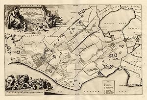
Map: Donger Deel West zyde der Pasens, de derde Grietenije van Ooster Goo.This regional map of the Westdongeradeel, part of the Province of Friesland, The Netherlands shows the situation around 1718. Grietenijen later turned into the present day towns. On this detailed map you will find: Dokkum, Hantumhuysen, Holwert, Bornwert,…De Wadden and much more detailed information. With the coat of arms of the Aylva family. Copperplate engraving on verge type hand laid paper with watermark. Description: This detailed original antique map originates from: 'Uitbeelding der Heerlijkheit Friesland '', by B. Schotanus a Sterringa and published by F. Halma in 1718. This Atlas is considered the best atlas of Friesland, the Netherlands.Artists and Engravers: The author is Bernardus Schotanus a Sterringa (1640-1704). The publisher is Francois Halma (1653-1722). Some of the Grietenije kaarten in this work are signed by Jan and Gaspar Luyken / Luiken as the engravers. Condition: Fine. General age related toning and occasional light staining from handling as visible on image. Storage location: B21-16 The overall size is ca. 25.6 x 21.3 inch. The image size is ca. 20.7 x 14.2 inch. The overall size is ca. 65 x 54 cm. The image size is ca. 52.5 x 36 cm.
- Signed
- Map
Seller: ThePrintsCollector, Zeeland, , NetherlandsThePrintsCollector
Contact seller5-star sellerCondition: Used
US$ 279.53
US$ 20.57 shippingShips from Netherlands to U.S.A.Quantity: 1 available
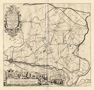
Map: Gaasterland, de zevende Grietenije van de Zevenwolden - This regional map of the Gaasterland Grietenij, part of the Province of Friesland, The Netherlands shows the situation around 1718. Grietenijen later turned into the present day towns. On this detailed map you will find: Sloten, Harich, Slotermeer, Olde Mirdum, Neijemi…rdum, Balk and much more detailed information. Copperplate engraving on verge type hand laid paper with watermark. Description: This detailed original antique map originates from: 'Uitbeelding der Heerlijkheit Friesland '', by B. Schotanus a Sterringa and published by F. Halma in 1718. This Atlas is considered the best atlas of Friesland, the Netherlands.Artists and Engravers: The author is Bernardus Schotanus a Sterringa (1640-1704). The publisher is Francois Halma (1653-1722). Some of the Grietenije kaarten in this work are signed by Jan and Gaspar Luyken / Luiken as the engravers. Condition: Fine. General age related toning and occasional light staining from handling as visible on image. Storage location: B21-07 The overall size is ca. 25.6 x 21.7 inch. The image size is ca. 20.3 x 13.6 inch. The overall size is ca. 65 x 55 cm. The image size is ca. 51.5 x 34.5 cm.
- Signed
- Map
Seller: ThePrintsCollector, Zeeland, , NetherlandsThePrintsCollector
Contact seller5-star sellerCondition: Used
US$ 291.30
US$ 20.57 shippingShips from Netherlands to U.S.A.Quantity: 1 available
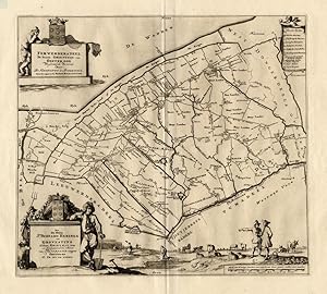
Map: Donger Deel Oost zyde der Pasens, de vierde Grietenije van Ooster Goo- This regional map of the Oost Dongeradeel Grietenij, part of the Province of Friesland, The Netherlands shows the situation around 1718. Grietenijen later turned into the present day towns. On this detailed map you will find: Engwierum, Dokkum, Aenjum, N…ijkerk, Metzelwier, Wetzens and much more detailed information. With the coat of arms of the Aylva family. Copperplate engraving on verge type hand laid paper with watermark. Description: This detailed original antique map originates from: 'Uitbeelding der Heerlijkheit Friesland '', by B. Schotanus a Sterringa and published by F. Halma in 1718. This Atlas is considered the best atlas of Friesland, the Netherlands.Artists and Engravers: The author is Bernardus Schotanus a Sterringa (1640-1704). The publisher is Francois Halma (1653-1722). Some of the Grietenije kaarten in this work are signed by Jan and Gaspar Luyken / Luiken as the engravers. Condition: Fine. General age related toning and occasional light staining from handling as visible on image. Storage location: B21-12 The overall size is ca. 25.2 x 21.7 inch. The image size is ca. 18.1 x 16.9 inch. The overall size is ca. 64 x 55 cm. The image size is ca. 46 x 43 cm.
- Signed
- Map
Seller: ThePrintsCollector, Zeeland, , NetherlandsThePrintsCollector
Contact seller5-star sellerCondition: Used
US$ 291.30
US$ 20.57 shippingShips from Netherlands to U.S.A.Quantity: 1 available
Map: Ferwerdera Deel, de tweede Grietenije van Ooster Goo- This regional map of the Ferwerderadeel, part of the Province of Friesland, The Netherlands shows the situation around 1718. Grietenijen later turned into the present day towns. On this detailed map you will find: Nyekerk, Marrum, Hallum, Blye, Wanswerd and much more det…ailed information. With the coat of arms of the Heringa Grovestins family. Copperplate engraving on verge type hand laid paper with watermark. Description: This detailed original antique map originates from: 'Uitbeelding der Heerlijkheit Friesland '', by B. Schotanus a Sterringa and published by F. Halma in 1718. This Atlas is considered the best atlas of Friesland, the Netherlands.Artists and Engravers: The author is Bernardus Schotanus a Sterringa (1640-1704). The publisher is Francois Halma (1653-1722). Some of the Grietenije kaarten in this work are signed by Jan and Gaspar Luyken / Luiken as the engravers. Condition: Fine. General age related toning and occasional light staining from handling as visible on image. Storage location: B21-15 The overall size is ca. 25.6 x 21.7 inch. The image size is ca. 18.7 x 16.5 inch. The overall size is ca. 65 x 55 cm. The image size is ca. 47.5 x 42 cm.
- Signed
- Map
Seller: ThePrintsCollector, Zeeland, , NetherlandsThePrintsCollector
Contact seller5-star sellerCondition: Used
US$ 291.30
US$ 20.57 shippingShips from Netherlands to U.S.A.Quantity: 1 available
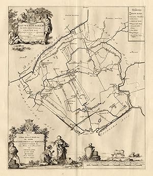
Map: Rauwerderhem, de elfde Grietenije van Ooster Goo. This regional map of the Rauwerderhem Grietenij, part of the Province of Friesland, The Netherlands shows the situation around 1718. Grietenijen later turned into the present day towns. On this detailed map you will find: Deersum, Irnsum, Sibranda Buren, Ter Zool and much mo…re detailed information. With the coat of arms of the Nysten family. Copperplate engraving on verge type hand laid paper with watermark. Description: This detailed original antique map originates from: 'Uitbeelding der Heerlijkheit Friesland '', by B. Schotanus a Sterringa and published by F. Halma in 1718. This Atlas is considered the best atlas of Friesland, the Netherlands.Artists and Engravers: The author is Bernardus Schotanus a Sterringa (1640-1704). The publisher is Francois Halma (1653-1722). Some of the Grietenije kaarten in this work are signed by Jan and Gaspar Luyken / Luiken as the engravers. Condition: Fine. General age related toning and occasional light staining from handling as visible on image. Storage location: B21-09 The overall size is ca. 25.2 x 21.7 inch. The image size is ca. 14.4 x 16.9 inch. The overall size is ca. 64 x 55 cm. The image size is ca. 36.5 x 43 cm.
- Signed
- Map
Seller: ThePrintsCollector, Zeeland, , NetherlandsThePrintsCollector
Contact seller5-star sellerCondition: Used
US$ 299.54
US$ 20.57 shippingShips from Netherlands to U.S.A.Quantity: 1 available
Map: Kollumer Land en het Nieuw Kruys Land, de vijde Grietenije van Ooster Goo- This regional map of the Kollumerland and Nieuwkruisland Grietenij, part of the Province of Friesland, The Netherlands shows the situation around 1718. Grietenijen later turned into the present day towns. On this detailed map you will find: Dokkum, K…ollum, Burum, Lutke Woude, Oud Woude, Westergeest and much more detailed information. With the coat of arms of the Aylva family. Copperplate engraving on verge type hand laid paper with watermark. Description: This detailed original antique map originates from: 'Uitbeelding der Heerlijkheit Friesland '', by B. Schotanus a Sterringa and published by F. Halma in 1718. This Atlas is considered the best atlas of Friesland, the Netherlands.Artists and Engravers: The author is Bernardus Schotanus a Sterringa (1640-1704). The publisher is Francois Halma (1653-1722). Some of the Grietenije kaarten in this work are signed by Jan and Gaspar Luyken / Luiken as the engravers. Condition: Fine. General age related toning and occasional light staining from handling as visible on image. Storage location: B21-13 The overall size is ca. 25.2 x 21.7 inch. The image size is ca. 21.7 x 14.2 inch. The overall size is ca. 64 x 55 cm. The image size is ca. 55 x 36 cm.
- Signed
- Map
Seller: ThePrintsCollector, Zeeland, , NetherlandsThePrintsCollector
Contact seller5-star sellerCondition: Used
US$ 312.48
US$ 20.57 shippingShips from Netherlands to U.S.A.Quantity: 1 available
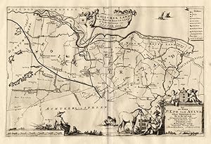
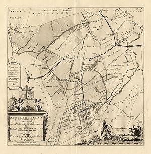
Map: Achtker Spelen, de zesde Grietenije van Ooster Goo- This regional map of the Achtkarspelen Grietenij, part of the Province of Friesland, The Netherlands shows the situation around 1718. Grietenijen later turned into the present day towns. On this detailed map you will find: Augustinus Gae, Opper Kooten, Ooster Buiren, Suyr…Huysum and much more detailed information. With the coat of arms of the Haarsma family. Copperplate engraving on verge type hand laid paper with watermark. Description: This detailed original antique map originates from: 'Uitbeelding der Heerlijkheit Friesland '', by B. Schotanus a Sterringa and published by F. Halma in 1718. This Atlas is considered the best atlas of Friesland, the Netherlands.Artists and Engravers: The author is Bernardus Schotanus a Sterringa (1640-1704). The publisher is Francois Halma (1653-1722). Some of the Grietenije kaarten in this work are signed by Jan and Gaspar Luyken / Luiken as the engravers. Condition: Fine. General age related toning and occasional light staining from handling as visible on image. Storage location: B21-14 The overall size is ca. 25.2 x 21.7 inch. The image size is ca. 17.7 x 17.3 inch. The overall size is ca. 64 x 55 cm. The image size is ca. 45 x 44 cm.
- Signed
- Map
Seller: ThePrintsCollector, Zeeland, , NetherlandsThePrintsCollector
Contact seller5-star sellerCondition: Used
US$ 312.48
US$ 20.57 shippingShips from Netherlands to U.S.A.Quantity: 1 available
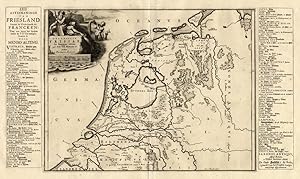
Map: 'Descriptio Frisiae sub Francorum reditum.' (Afteekeninge van Friesland ontrent de weederkomste der Francken.; English: Friesland / The Netherlands in the time of the Franks.) This map is bordered bij two columns with historic and 18th c. names of towns. The decorative cartouche shows a river god and mermaid. Copperplate en…graving on verge type hand laid paper with watermark. Description: This detailed original antique map originates from: 'Uitbeelding der Heerlijkheit Friesland .', by B. Schotanus a Sterringa and published by F. Halma in 1718. This Atlas is considered the best atlas of Friesland, the Netherlands.Artists and Engravers: The author is Bernardus Schotanus a Sterringa (1640-1704). The publisher is Francois Halma (1653-1722). Some of the Grietenije kaarten in this work are signed by Jan and Gaspar Luyken / Luiken as the engravers. Condition: Fine. General age related toning and occasional light staining from handling as visible on image. Storage location: B21-01 The overall size is ca. 25.2 x 20.7 inch. The image size is ca. 22.6 x 12.8 inch. The overall size is ca. 64 x 52.5 cm. The image size is ca. 57.5 x 32.5 cm.

- Signed
- Map
Seller: ThePrintsCollector, Zeeland, , NetherlandsThePrintsCollector
Contact seller5-star sellerCondition: Used
US$ 317.19
US$ 20.57 shippingShips from Netherlands to U.S.A.Quantity: 1 available
Map: Menalduma Deel . eerste Grietenije van Wester Goo- This regional map of the Menaldumadeel, part of the Province of Friesland, The Netherlands shows the situation around 1718. Grietenijen later turned into the present day towns. On this detailed map you will find: Marsum, Deynum, Blessum, Belkum, Menaam and much more detaile…d information. With the coat of arms of the Sjuk Tjaard van Burmania op Jornsma family. Copperplate engraving on verge type hand laid paper with watermark. Description: This detailed original antique map originates from: 'Uitbeelding der Heerlijkheit Friesland '', by B. Schotanus a Sterringa and published by F. Halma in 1718. This Atlas is considered the best atlas of Friesland, the Netherlands.Artists and Engravers: The author is Bernardus Schotanus a Sterringa (1640-1704). The publisher is Francois Halma (1653-1722). Some of the Grietenije kaarten in this work are signed by Jan and Gaspar Luyken / Luiken as the engravers. Condition: Fine. General age related toning and occasional light staining from handling as visible on image. Storage location: B21-14 The overall size is ca. 25.6 x 21.7 inch. The image size is ca. 16.9 x 15 inch. The overall size is ca. 65 x 55 cm. The image size is ca. 43 x 38 cm.
- Signed
- Map
Seller: ThePrintsCollector, Zeeland, , NetherlandsThePrintsCollector
Contact seller5-star sellerCondition: Used
US$ 317.19
US$ 20.57 shippingShips from Netherlands to U.S.A.Quantity: 1 available
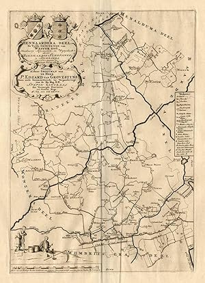
Map: Hennaardera Deel, de vijfde Grietenije van Wester Goo- This regional map of the Hennaardera Deel Grietenij, part of the Province of Friesland, The Netherlands shows the situation around 1718. Grietenijen later turned into the present day towns. On this detailed map you will find: Wielsrijp, Bajum, Spannum, Wierum, Ooster En…d and much more detailed information. With the coat of arms of the Edzard van Grovestins family. Copperplate engraving on verge type hand laid paper with watermark. Description: This detailed original antique map originates from: 'Uitbeelding der Heerlijkheit Friesland '', by B. Schotanus a Sterringa and published by F. Halma in 1718. This Atlas is considered the best atlas of Friesland, the Netherlands.Artists and Engravers: The author is Bernardus Schotanus a Sterringa (1640-1704). The publisher is Francois Halma (1653-1722). Some of the Grietenije kaarten in this work are signed by Jan and Gaspar Luyken / Luiken as the engravers. Condition: Fine. General age related toning and occasional light staining from handling as visible on image. Storage location: B21-11 The overall size is ca. 25.6 x 21.3 inch. The image size is ca. 11.6 x 16.5 inch. The overall size is ca. 65 x 54 cm. The image size is ca. 29.5 x 42 cm.

- Signed
Seller: Bartele Gallery - The Netherlands, Langweer, FRL, NetherlandsBartele Gallery - The Netherlands
Contact seller5-star sellerCondition: Used
US$ 457.83
US$ 19.43 shippingShips from Netherlands to U.S.A.Quantity: 1 available
Antique map titled 'Stellingwerf Oost-Eynde, de negende Grietenije van de Sevenwolden'. This regional map of the Oost Stellingwerf Grietenij, part of the Province of Friesland, The Netherlands shows the situation around 1718. Grietenijen later turned into the present day towns. On this detailed map you will find: Oosterwolde, Ap…pelscha, Makkinga, Elsloo and much more detailed information. With the coat of arms of the Lijklama family. This map originates from 'Uitbeelding der Heerlijkheit Friesland '', by B. Schotanus a Sterringa and published by F. Halma in 1718. This Atlas is considered the best atlas of Friesland, the Netherlands. Artists and Engravers: The author is Bernardus Schotanus a Sterringa (1640-1704). The publisher is Francois Halma (1653-1722). Some of the Grietenije kaarten in this work are signed by Jan and Gaspar Luyken / Luiken as the engravers. Condition: Good, general age-related toning. Minor wear, blank verso. Please study image carefully. Date: 1718 Overall size: 66 x 55 cm. Image size: 52 x 48 cm. We sell original antique maps to collectors, historians, educators and interior decorators all over the world. Our collection includes a wide range of authentic antique maps from the 16th to the 20th centuries. Buying and collecting antique maps is a tradition that goes back hundreds of years. Antique maps have proved a richly rewarding investment over the past decade, thanks to a growing appreciation of their unique historical appeal. Today the decorative qualities of antique maps are widely recognized by interior designers who appreciate their beauty and design flexibility. Depending on the individual map, presentation, and context, a rare or antique map can be modern, traditional, abstract, figurative, serious or whimsical. We offer a wide range of authentic antique maps for any budget.

- Signed
Seller: Bartele Gallery - The Netherlands, Langweer, FRL, NetherlandsBartele Gallery - The Netherlands
Contact seller5-star sellerCondition: Used
US$ 494.31
US$ 19.43 shippingShips from Netherlands to U.S.A.Quantity: 1 available
Antique map titled 'Stellingwerf Oost-Eynde, de negende Grietenije van de Sevenwolden'. This regional map of the Oost Stellingwerf Grietenij, part of the Province of Friesland, The Netherlands shows the situation around 1718. Grietenijen later turned into the present day towns. On this detailed map you will find: Oosterwolde, Ap…pelscha, Makkinga, Elsloo and much more detailed information. With the coat of arms of the Lijklama family. This map originates from 'Uitbeelding der Heerlijkheit Friesland '', by B. Schotanus a Sterringa and published by F. Halma in 1718. This Atlas is considered the best atlas of Friesland, the Netherlands. Artists and Engravers: The author is Bernardus Schotanus a Sterringa (1640-1704). The publisher is Francois Halma (1653-1722). Some of the Grietenije kaarten in this work are signed by Jan and Gaspar Luyken / Luiken as the engravers. Condition: Fair. Some foxing and age-related toning. Marginal tears. Please study image carefully. Date: 1718 Overall size: 62.5 x 54 cm. Image size: 53 x 48.5 cm. We sell original antique maps to collectors, historians, educators and interior decorators all over the world. Our collection includes a wide range of authentic antique maps from the 16th to the 20th centuries. Buying and collecting antique maps is a tradition that goes back hundreds of years. Antique maps have proved a richly rewarding investment over the past decade, thanks to a growing appreciation of their unique historical appeal. Today the decorative qualities of antique maps are widely recognized by interior designers who appreciate their beauty and design flexibility. Depending on the individual map, presentation, and context, a rare or antique map can be modern, traditional, abstract, figurative, serious or whimsical. We offer a wide range of authentic antique maps for any budget.


