

Order Total (1 Item Items):
Shipping Destination:

Indes Feuille (9 results)
Skip to main search results
Search filters
Product Type
- All Product Types
- Books (5)
- Magazines & Periodicals (No further results match this refinement)
- Comics (No further results match this refinement)
- Sheet Music (No further results match this refinement)
- Art, Prints & Posters (No further results match this refinement)
- Photographs (No further results match this refinement)
- Maps (4)
- Manuscripts & Paper Collectibles (No further results match this refinement)
Condition Learn more
- New (No further results match this refinement)
- As New, Fine or Near Fine (3)
- Very Good or Good (No further results match this refinement)
- Fair or Poor (No further results match this refinement)
- As Described (6)
Binding
- All Bindings
- Hardcover (No further results match this refinement)
- Softcover (2)
Collectible Attributes
- First Edition (No further results match this refinement)
- Signed (No further results match this refinement)
- Dust Jacket (No further results match this refinement)
- Seller-Supplied Images (9)
- Not Print on Demand (9)
Language (2)
Price
- Any Price
- Under US$ 25 (No further results match this refinement)
- US$ 25 to US$ 50
- Over US$ 50
Free Shipping
- Free Shipping to U.S.A. (No further results match this refinement)
Seller Location
Seller Rating
-
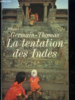
LA TENTATION DES INDES - LE COTE FEUILLE QUI EST EN MOI ASPIRE A RETOURNER EN INDE
Couverture souple. Condition: bon. RO30125352: 1982. In-8. Broché. Bon état, Couv. convenable, Dos satisfaisant, Intérieur frais. 382 pages agrémentées d'une planche de photos noir et blanc. . . . Classification Dewey : 848-Ecrits divers, citations, journaux intimes, souvenirs, mémoires.
-
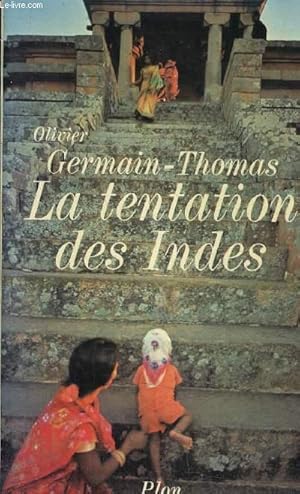
LA TENTATION DES INDES - LE COTE FEUILLE QUI EST EN MOI ASPIRE A RETOURNER EN INDE.
Couverture souple. Condition: bon. R240050361: 1980. In-8. Broché. Bon état, Couv. convenable, Dos satisfaisant, Intérieur acceptable. 382 pages - planche de photographies en noir et blanc. . . . Classification Dewey : 954-Asie du Sud, Inde.
-

Indes IIe Feuille.
Published by Paris: 1783, 1783
Seller: Peter Harrington. ABA/ ILAB., London, United Kingdom
Association Member: ABA ILAB PBFA
Seller rating 5 out of 5 stars

US$ 163.17
US$ 29.04 shipping
Ships from United Kingdom to U.S.A.Quantity: 1 available
Add to basketMap of India and Ceylon from the Atlas Moderne. Copper engraving. Hand coloured. Very good condition. Image size: 29 x 41 cm.
-
Indes Ière Feuille [and] Indes IIe Feuille.
Published by (Circa1780)., Paris., 1780
Seller: Asia Bookroom ANZAAB/ILAB, Canberra, ACT, Australia
Association Member: ANZAAB ILAB
Seller rating 5 out of 5 stars
A pair of hand coloured engraved maps, 32 x 43 cms (maps including platemark), 38.2 x 52.3 cms (sheet), central folds, marginal age toning, scant spotting, small wormhole at the head of the second sheet chiefly affecting the border, but both in very good condition. A pair of highly detailed maps of India by the French Royal cartographer Rigobert Bonne (his predecessor was the eminent Jacques Nicolas Bellin). The first sheet shows the northern portion of the subcontinent, reaching from Kandahar (modern-day Afghanistan) in the west across northern India and Pakistan, and stretching east to Burma (Pegu) and the second encompasses Southern India (including Ceylon/Sri Lanka), Southeast Asia, and the East Indies (Maritime Southeast Asia). They feature critical coastal and marine navigation details typical of Bonne's scientific approach to mapping. A most attractive pair of maps.
-

Indes IVe. Feuille
Published by Artist: Lattre de Jean ( - 1788 ) Paris ca : 1771, 1722
Seller: Antique Sommer& Sapunaru KG, München, Germany
Seller rating 4 out of 5 stars

Technic: Copper print, colorit: original colored, condition: Perfect condition, size (in cm): 30 x 40,5 cm, Map shows Indonesia, the southern Philippines and a large part of Malaysia. From the "Atlas Moderne." Plates no. D 26., cartographer Rigobert Bonne.
-

Indes IIe. Feuille.
Publication Date: 1770
Seller: Geographicus Rare Antique Maps, Brooklyn, NY, U.S.A.
Association Member: ABAA ESA ILAB
Seller rating 4 out of 5 stars
Map
Very good condition. Original centerfold exhibits minor toning. Blank on verso. Size 11.75 x 16.5 Inches. A beautiful example of Rigobert Bonne's 1770 decorative map of southern India. Covers both the Malabar and Coromandel coasts as well as the Maldives, Ceylon (Sri Lanka), the Andaman Islands, and parts of Sumatra and Southeast Asia. Rhumb lines throughout. Arrows in the Indian Ocean show the direction of prevailing winds during the dry season and the monsoon season. This important Indian Ocean wind system, which blew one way for half the year, and the opposite for the other half, created a critical trade artery from antiquity to pre-modern times. Drawn by R. Bonne in 1770 for issue as plate no. B 26 in Jean Lattre's 1776 issue of the Atlas Moderne . References: Rumsey 2612.054. Phillips (Atlases) 664. National Maritime Museum, 215.
-

Indes Iere. Feuille.
Publication Date: 1770
Seller: Geographicus Rare Antique Maps, Brooklyn, NY, U.S.A.
Association Member: ABAA ESA ILAB
Seller rating 4 out of 5 stars
Map
Very good condition. Original centerfold exhibits minor toning. Blank on verso. Size 12 x 16.5 Inches. A beautiful example of Rigobert Bonne's 1770 decorative map of northern India. Covers the subcontinent from Kandahar east as far as Burma (Pegu) and south to just past Goa. Names countless important Indian cities, river systems and mines. Rhumb lines appear in nautical zones. Arrows in the lower left and lower right show the direction of prevailing winds during the dry season and the monsoon season. Drawn by R. Bonne in 1770 for issue as plate no. A 26 in Jean Lattre's 1776 issue of the Atlas Moderne . References: Rumsey 2612.053. Phillips (Atlases) 664. National Maritime Museum, 215.
-

Indes IVe Feuille
Published by Jean Lattré, 1776
Seller: Antiquariaat Dat Narrenschip, Middelburg, Netherlands
Seller rating 5 out of 5 stars
Map
No Binding. Condition: Fine. Antique map of Indonesia, also showing the southern Philippines and most of Malaysia. Backside blank. Copper engraving with old colour, published in Paris in 1776 by Jean Lattré in "Atlas Moderne." Cartographer: Rigobert Bonne. Dimensions (image): 29 x 41 cm.
-

Indes IVe. Feuille.
Publication Date: 1770
Seller: Geographicus Rare Antique Maps, Brooklyn, NY, U.S.A.
Association Member: ABAA ESA ILAB
Seller rating 4 out of 5 stars
Map
Very good condition. Original centerfold exhibits minor toning. Blank on verso. Size 12 x 16.5 Inches. A beautiful example of Rigobert Bonne's 1771 decorative map the East Indies. Covers from the Gulf of Siam (Gulf of Thailand) and Malacca (Malaysia) eastward to include parts of Sumatra, Java, Borneo, the Celebes, parts of Cambodia, the southern Philippine Islands, and New Guinea. Offers considerable detail of the region. Notes the Straight of Singapore (Det. de Sin Capura) and shows but does not label the island of Singapore. In Borneo, this map provides good detail along the Banjermassin or Barito River, detailing numerous villages and trading stations. Names Bali and Lombok as well as Batavia. Several of the southern islands are drawn with their southern shores ghosted in - suggesting an uncertain coastline. This is also the case with much of New Guinea (Nouvelle Guinee), which was largely unexplored well into the 19th century. Rhumb lines throughout. Arrows in the lower right show the direction of prevailing winds during the dry season and the monsoon season. A fine map of the region. Drawn by R. Bonne in 1771 for issue as plate no. D 26 in Jean Lattre's 1776 issue of the Atlas Moderne . References: Rumsey 2612.056. Phillips (Atlases) 664. National Maritime Museum, 215.

![Seller image for Indes Ière Feuille [and] Indes IIe Feuille. for sale by Asia Bookroom ANZAAB/ILAB](https://pictures.abebooks.com/inventory/md/md32452662261.jpg)
