Johnsons Australia (24 results)
 More images
Language: English
- Softcover
Seller: Dublin Bookbrowsers, Dublin, NONE, IrelandDublin Bookbrowsers
Contact seller2-star sellerCondition: Used - Good
US$ 51.86
US$ 11.90 shippingShips from Ireland to U.S.A.Quantity: 1 available
Soft cover. Condition: Good. This is a book with Pertinent and relevant press clippins stuck to pages internally. Is a detailed account of the flight Amy Johnson for Australia and left England on Monday 5th May, 1930. Very detailed account with press clippings neatly stuck to pages through out. Some wear & nicks to covers. Else…good.

Published by John Fairfax & Sons Ltd., Sydney, 1934
- Softcover
- First Edition
Seller: Heartwood Books and Art, Fort Lauderdale, FL, U.S.A.Heartwood Books and Art
Contact seller5-star sellerCondition: Used - Very good
US$ 50.00
US$ 7.00 shippingShips within U.S.A.Quantity: 1 available
Softcover. Condition: Very Good. First Edition. Art in Australia: Third Series, Number 54, Robert Johnson's Landscapes A firm copy with traces of glue repair to spine ends. Robert Johnson's Landscapes. Paper binding with flaps over plain covers. Includes color plates. 9.75 x 7.5 inches, approx. Sydney Ure Smith(Editor) Leon Gell…ert(Editor) (illustrator). BOOK.
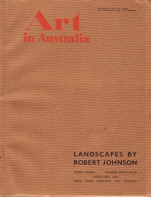
Art in Australia. Third Series Number 54. Special Issue - Robert Johnson's Landscapes
[ART IN AUSTRALIA] URE SMITH, Sydney & GELLERT, Leon (editors)
Published by Art in Australia, Sydney, 1934
- Softcover
- First Edition
Seller: Rare Illustrated Books, Centennial Park, NSW, AustraliaRare Illustrated Books
Contact seller4-star sellerCondition: Used
US$ 50.75
US$ 20.00 shippingShips from Australia to U.S.A.Quantity: 1 available
Of interest: long article illustrated with colour plates by B.J. Waterhouse on the painting of Robert Johnson and an additional appreciation by Walter Taylor. Small quarto, original printed wrappers, colour plates, full-page black & white images; a near fine copy.

Published by Johnson 1866,7,8 or 9., NY, 1866
- Softcover
Seller: Quiet Friends IOBA, Lyndonville, NY, U.S.A.Quiet Friends IOBA
Contact seller4-star sellerAssociation member: IOBA
Softcover. "FINE" map, hand colored, 16.5" wide x 13.5" high. FLAWLESS. No cp date but actually 1866-9. Johnson's name (by itself, without the added "Browning", "Ward" or "and son") is printed in double faced outline and was not used until 1866. In addition the particular border style, with a five pointed star at each corner, we…nt out in 1869. Hence the 1866-9 date. This info from Ira Lourie's Johnson Map Project. "FINE" map. Published between 1866 & 1869, but no cp date.

Published by Chicago. Rand MacNally & Co., 1887
- Hardcover
- First Edition
Seller: The Antique Bookshop & Curios (ANZAAB), Crows Nest, NSW, AustraliaThe Antique Bookshop & Curios (ANZAAB)
Contact seller3-star sellerCondition: Used
US$ 89.34
US$ 22.00 shippingShips from Australia to U.S.A.Quantity: 1 available
Original gilt lettered & decorated green cloth. 400pp. Frontispiece portrait & 37 b/w ills. Cloth a little rubbed else a good copy. . 1st US ed. Osmun Johnson was a Norwegian born American writer & traveller who travelled across the Pacific Ocean four times. Chapter XII is about his time in Austrlia.

Published by Johnson & Browning, Richmond, VA, 1861
- Softcover
- First Edition
- Art Print
Seller: Dorley House Books, Inc., Hagerstown, MD, U.S.A.Dorley House Books, Inc.
Contact seller4-star sellerCondition: Used - Very good
US$ 175.00
US$ 8.65 shippingShips within U.S.A.Quantity: 1 available
Unbound. Condition: Very Good. 1st. Plate #88; lovely hand-colored map; of AUSTRALIA at the beginning of the US Civil War, decorative strapwork border; w/ Counties, cities, roads, rivers, railroads, wagon roads,canals, ports, etc. w/insets of Yesso & Nagasaki Size: 17" x 13.5". Handcolored Map (illustrator).
Published by A.J. Johnson, New York, 1867
Seller: Nicholas D. Riccio Rare Books, ABAA, Florham Park, NJ, U.S.A.Nicholas D. Riccio Rare Books, ABAA
Contact seller4-star sellerNew York: A.J. Johnson, 1867. Unbound, colored engraved map, decorative boarder, 16" x13". Some toning, browning, and aging; otherwise fairly bright and clean and in very good condition. Alvin Jewett Johnson (1827-1884) appears to have entered the map publishing business in 1860. It appears that he obtained J.H. Colton's map cop…yrights, and published the first installment of the Johnson's New Illustrated (Steel Plate) Family Atlas In that year. Many of the maps Johnson would use would bear the J.H. Colton copyright for many years. Johnson's Atlas would run from 1860 to 1885. While Johnson would use somewhat similar boarder designs, map coloring would sometimes appear a little heavier than the earlier Colton maps. This map of Australia is from the 1867 edition of Johnson's Illustrated Family Atlas, and has nice coloring. While the map doesn't provide great detail, Australia is kind of the wide open spaces at that time. However, the map does provide a list of counties for the different parts of the country. May require extra postage. Ristow 325-326.

Seller: Art Source International Inc., Boulder, CO, U.S.A.Art Source International Inc.
Contact seller5-star sellerThis antique map came from Johnsons New Illustrated (Steel Plate) Family Atlas, published in 1863, by Johnson and Ward. These maps are some of the most colorful and accurate maps produced in the 1860's. Johnson maps are characterized by hand coloring in red and green and distinctive borders, including iron scrollwork and a Celti…c design. This beautiful map of Australia shows the large amount of unknown territory in Australia in the 1860's. This map measures 16 inches by 13 inches.

Published by Johnson and Ward. (Circa1865)., 1865
Seller: Asia Bookroom ANZAAB/ILAB, Canberra, ACT, AustraliaAsia Bookroom ANZAAB/ILAB
Contact seller5-star sellerCondition: Used
US$ 107.21
US$ 21.25 shippingShips from Australia to U.S.A.Quantity: 1 available
Hand coloured map, 32.3 x 39.7 x cms (including the decorative border); 35.6 x 45.8 cms (sheet), key to major centres, unrelated text on verso, sheet age toned, in very good condition. Detailed map from the leading mid 19th Century American firm of Johnson and Ward. Although Tasmania was known as such from 1856, the map refers t…o "Van Diemen Land".

Seller: Art Source International Inc., Boulder, CO, U.S.A.Art Source International Inc.
Contact seller5-star sellerThis map was issued as part of "Johnson's New Illustrated Family Atlas of the World." This atlas was awarded the first prize medal at the Universal Expositions in Paris in 1867 and 1878. A.J. Johnson published his first atlas in 1860 as successors to J.H. Colton & Co. Editions of this atlas ceased in 1885. These later editions o…f the Johnson atlas are some of the finest the company ever produced and are known for the geometric border. This map measures 17 inches by 23 inches.

Seller: Art Source International Inc., Boulder, CO, U.S.A.Art Source International Inc.
Contact seller5-star sellerJohnson and Browning issued this map in "Johnsons New Illustrated Family Atlas" in 1862. Australia is illustrated on this detailed, hand colored map. Regions are distinguished by bright pastel colors. Railroads, major roads, rivers, lakes, deserts, and the names of regions and important cities are identified. This map measures 1…5 inches by 12.75 inches.

Seller: Art Source International Inc., Boulder, CO, U.S.A.Art Source International Inc.
Contact seller5-star sellerNear the forefront of the atlas publication industry for a quarter century was mapmaker and aggressive marketer Alvin Jewitt Johnson. Around 1860, in a transaction that remains somewhat mysterious, Johnson acquired a set of detailed plates from J.H. Colton, one of the foremost mapmakers of the century, and used them to print the… Johnson atlas that was to find its way into homes across the country. Johnsons New Illustrated Family Atlas was first published in 1860, and today these maps have become prized collectibles and true works of cartographic art. The attention to detail and fine hand coloring of these maps make them some of the best collectibles maps from the 19th century. This map measures 15.5 inches by 12.5 inches.

Seller: Art Source International Inc., Boulder, CO, U.S.A.Art Source International Inc.
Contact seller5-star sellerNear the forefront of the atlas publication industry for a quarter century was mapmaker and aggressive marketer Alvin Jewitt Johnson. Around 1860, in a transaction that remains somewhat mysterious, Johnson acquired a set of detailed plates from J.H. Colton, one of the foremost mapmakers of the century, and used them to print the… Johnson atlas that was to find its way into homes across the country. Johnsons New Illustrated Family Atlas was first published in 1860, and today these maps have become prized collectibles and true works of cartographic art. The attention to detail and fine hand coloring of these maps make them some of the best collectibles maps from the 19th century. This signal page map illustrates Australia. Counties, cities, towns and topographical features are noted. Great detail and coloring!' This map measures 13 inches by 15.5 inches.

Seller: Art Source International Inc., Boulder, CO, U.S.A.Art Source International Inc.
Contact seller5-star sellerThis finely detailed map came from Johnsons New Illustrated (Steel Plate) Family Atlas. Map shows cities and towns, rail lines, rivers and lakes, and wagon trails/roads. Each region is individually colored, and includes the traditional decorative border. This map measures 15.5 inches by 12.5 inches.

Seller: Art Source International Inc., Boulder, CO, U.S.A.Art Source International Inc.
Contact seller5-star sellerThis antique map came from Johnson's New Illustrated (Steel Plate) Family Atlas, published in 1867, by A.J. Johnson. These maps are some of the most colorful and accurate maps produced in the 1860's, their attention to detail and the fine steel engraving make them works of art. Johnson maps are characterized by hand coloring in…red, green, yellow, and pink and distinctive borders, including iron scrollwork and a Celtic design. This beautiful map of Australia shows countries, states and or provinces and regions, cities and towns, lakes, rivers, and water bodies, railroads, forts, and wagon trails. A fine piece that would make a nice addition to any wall in a home or office. This map measures 15.5 inches by 13 inches.

Seller: Art Source International Inc., Boulder, CO, U.S.A.Art Source International Inc.
Contact seller5-star sellerThis antique map came from Johnson's New Illustrated (Steel Plate) Family Atlas, published in 1867, by A.J. Johnson. These maps are some of the most colorful and accurate maps produced in the 1860's, their attention to detail and the fine steel engraving make them works of art. Johnson maps are characterized by hand coloring in…red, green, yellow, and pink and distinctive borders, including iron scrollwork and a Celtic design. This beautiful map of Australia and the East Indies shows countries, states and or provinces and regions, cities and towns, lakes, rivers, and water bodies, railroads, forts, and wagon trails. A fine piece that would make a nice addition to any wall in a home or office. Includes an inset map of New Zealand. This map measures 17 inches by 22.75 inches.

Published by Johnson & Browning ca. 1860, New York, 1860
Seller: Haaswurth Books, Binghamton, NY, U.S.A.Haaswurth Books
Contact seller5-star sellerAssociation member: IOBA
Condition: Used - Good
US$ 95.00
US$ 6.95 shippingShips within U.S.A.Quantity: 1 available
Engraving. Condition: Good. Large hand-colored map, 46 x 36 cm (18 x 14 1/4 inches), some incidental spotting, suitable for framing. Small nicks to the paper on one edge that will mat out when framed. Will ship flat. Removed from a bound volume, Johnson's New Illustrated Family Atlas. This is an example of Johnson & Browning's u…se of a map first published by J. H. Colton & Co. and copyrighted by Colton in 1855. It has Colton's copyright date and was republished about the year 1860. Hand-colored in pink, cream, and green. This map has the vast interior of Australia with very few references showing the limits of exploration at this time.Alvin Jewett Johnson (1827-1884), b. Wallingford, Vermont; school teacher, for some years a book and map seller for J. H. Colton and Co. After some efforts at publishing his own maps, Johnson found success with his Family Atlas, publishing them in Richmond, Virginia and in New York City beginning in 1860. He and his partner Ross C. Browning (1822-1899) evidently purchased rights to Colton's maps, as they appear in the first Johnson's Family Atlas. Johnson updated his maps as cartography became more accurate, and Atlases during the 1860's were bound with maps bearing various dates until that particular map was updated. Johnson and Browning maps were published 1860-1862; Johnson and Ward were years 1862-1866; maps published by A. J. Johnson, A. J. Johnson and Son, A. J. Johnson & Co., date from 1866-1887.Johnson's hand-colored maps are known for their accuracy to detail and are an important record of internal improvements and westward expansion. All are suitable for framing and valued by collectors.

Seller: Berkelouw Rare Books, Berrima, NSW, AustraliaBerkelouw Rare Books
Contact seller4-star sellerCondition: Used
US$ 89.34
US$ 38.00 shippingShips from Australia to U.S.A.Quantity: 1 available
Sydney 1934. Sm. 4to. Orig. printed wrapper with yapp edges (spine chipped). (70pp.). With 6 coloured plates, num. b/w plates, and contemp. adverts. Light toning on title-page, otherwise a fine copy.

- First Edition
- Map
Seller: Geographicus Rare Antique Maps, Brooklyn, NY, U.S.A.Geographicus Rare Antique Maps
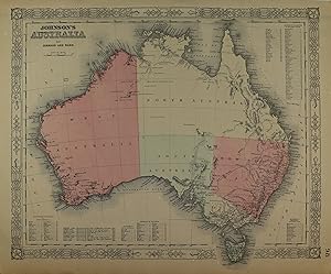
Contact seller4-star seller1st Edition. Very good. A few minor spots jut ouside of bottom margin. Blank on verso. Light overall toning. Size 13 x 16 Inches. A beautiful example of A. J. Johnson's 1862 map of Australia. One of the earlier states in the Johnson Australia series, this map depicts the continent with good detail along the coast and a largely u…nexplored interior. Shows the Torrens Basin, the Stony Desert, Traveler's Valley, and the extant of Sturt's inland exploration. Tables in the corners show references to various counties in each provinces. A smaller table in the lower left provides a time line for the exploration of the continent, noting the dates associated with important navigators including Tasman, Arnhem, Hartog, Edel, Flinders, and others. Features the strapwork style border common to Johnson's atlas work from 1860 to 1863. Published by A. J. Johnson and Ward as plate number 88 in the 1862 edition of Johnson's New Illustrated Family Atlas . This is the first edition of the Family Atlas to bear the Johnson and Ward imprint.

- First Edition
- Map
Seller: Geographicus Rare Antique Maps, Brooklyn, NY, U.S.A.Geographicus Rare Antique Maps
Contact seller4-star seller1st Edition. Very good. Text on verso. Minor overall toning. Size 14 x 16.5 Inches. This is Johnson and Ward's 1864 map of Australia. The map covers the entire continent including Tasmania or Van Diemen's Land. Johnson's mappings of Australia, updated annually through the 1860s, offer a comprehensive overview of the exploration…of the continent's interior. This example depicts the continent with good detail along the coast and a largely unexplored interior. Shows the Torrens Basin, the Stony Desert, Traveler's Valley, and the extant of Sturt's inland exploration. Tables in the corners show references to various counties in each province. A smaller table in the lower left provides a time line for the exploration of the continent, noting the dates associated with important navigators including Tasman, Arnhem, Hartog, edel, Flinders, and others. Various towns, cities, rivers and several other topographical features are noted with relief shown by hachure. It features the fretwork style border common to Johnson's atlas work from 1863 to 1869. Steel plate engraving prepared by A. J. Johnson for publication as plate no. 98 in the 1864 edition of his New Illustrated Atlas . This is the first edition of the Johnson'sAtlasto bear the Johnson & Ward imprint and the only edition to identify the firm as the 'Successors to Johnson and Browning (Successors to J. H. Colton and Company). References: Rumsey 0352.073. Philips (atlases) 843.
- Art Print
Seller: Graphik-Antiquariat Jason Düssel, Berlin, GermanyGraphik-Antiquariat Jason Düssel
Contact seller5-star sellerCondition: Used
US$ 235.65
US$ 62.92 shippingShips from Germany to U.S.A.Quantity: 1 available
Kolorierte Lithografie bei Johnson und Ward in New York erschienen. Coloured lithograph published by Johnson and Ward in New York, 1864. 32 x 39,5 cm. Blattformat: 35,5 x 45,4 cm. Gut erhalten.
- Photo
Seller: Sophie Dupre ABA ILAB PADA, Calne, United KingdomSophie Dupre ABA ILAB PADA
Contact seller2-star sellerCondition: Used
US$ 446.34
US$ 5.48 shippingShips from United Kingdom to U.S.A.Quantity: 1 available
showing her head and shoulders wearing her flying hat and goggles, 8½" x 6½", Estonia, This photo was taken when she visited Estonia on 16th February 1939. In May 1934, Batten successfully flew solo from England to Australia in the Gipsy Moth. Her trip of 14 days and 22 hours beat the existing England-to-Australia women's record… of English aviator Amy Johnson by over four days. For this achievement and for subsequent record-breaking flights, she was awarded the Harmon Trophy three times (1935, 1936, 1937). In 1936 she set another world record with a solo flight from England to New Zealand. At her birthplace of Rotorua she was honoured by local M ori, as she had been after the 1934 journey.

- Map
Seller: New World Cartographic, Chicago, IL, U.S.A.New World Cartographic
Contact seller4-star sellerBy: A.J. JohnsonDate: 1862 (published) New York.Dimensions: 12.25 x 15 inches (31.1 x 38.1cm).This is an authentic antique map of Australia. It was published in 1864 by AJ Johnson in New York.This color-coded map of Australia shows its various states and cities as they existed in the mid-19th century. It reflects a time in Austr…alia before the state of Queensland was recognized and the island of Tasmania was known as Van Diemen Land.Condition: map is in A condition. It is detailed and sharply colored, with light toning around the edges and a slight edge tear. The image also bears some light spotting.Inventory #185951200 W. 35th Street #425 Chicago, IL 60609 | P: (312) 496 - 3622.
 More images
Seller: Bartele Gallery - The Netherlands, Langweer, FRL, NetherlandsBartele Gallery - The Netherlands
Contact seller5-star sellerCondition: Used
US$ 388.83
US$ 19.45 shippingShips from Netherlands to U.S.A.Quantity: 1 available
Johnson's Australia Map, USA Published c.1864 ? Decorative Hand-Colored Map This is a finely engraved and hand-colored map titled Johnson's Australia published by Johnson and Ward in New York, circa 1864. It shows the political divisions of Australia as understood in mid-19th century American cartography, including West Australi…a, North Australia, South Australia, New South Wales, Victoria, and Tasmania. The map is notable for its decorative border, typical of Johnson atlases, with interlaced geometric and floral motifs framing the image. The colonies are shaded in pastel pink, green, and tan colors. Cities, settlements, rivers, mountain ranges, and coastal features are clearly marked, including Perth, Adelaide, Melbourne, Sydney, Brisbane, and Hobart Town. Offshore islands such as Tasmania and surrounding smaller islands are also shown. There is an extensive list of counties and references in the lower and right margins. Johnson and Ward were leading American publishers of maps and atlases in the mid-19th century. Their works combined clear geographic information with decorative appeal. Maps of Australia by Johnson are valued for documenting the colonial divisions before Australian federation in 1901. Condition report: Good condition. Strong impression with bright original hand coloring. Light general age toning and a few small spots or handling marks in the margins, typical for antique atlas maps. Some tears in the borders. Wide margins and plate mark intact. Framing suggestion: Frame with a simple dark wood or black frame and an archival off-white mat to highlight the pastel coloring and decorative border. UV-protective glass is recommended to preserve the paper quality and prevent fading.


