Order Total (1 Item Items):
Shipping Destination:

Johnsons Germany by Johnson (21 results)
Skip to main search results
Search filters
Product Type
- All Product Types
- Books (15)
- Magazines & Periodicals (No further results match this refinement)
- Comics (No further results match this refinement)
- Sheet Music (No further results match this refinement)
- Art, Prints & Posters (No further results match this refinement)
- Photographs (No further results match this refinement)
- Maps (6)
- Manuscripts & Paper Collectibles (No further results match this refinement)
Condition Learn more
- New (No further results match this refinement)
- As New, Fine or Near Fine (No further results match this refinement)
- Very Good or Good (No further results match this refinement)
- Fair or Poor (No further results match this refinement)
- As Described (21)
Binding
- All Bindings
- Hardcover (No further results match this refinement)
- Softcover (No further results match this refinement)
Collectible Attributes
- First Edition (4)
- Signed (No further results match this refinement)
- Dust Jacket (No further results match this refinement)
- Seller-Supplied Images (21)
- Not Print on Demand (21)
Language (1)
Price
- Any Price
- Under US$ 25 (No further results match this refinement)
- US$ 25 to US$ 50
- Over US$ 50
Free Shipping
- Free Shipping to U.S.A. (No further results match this refinement)
Seller Location
Seller Rating
-
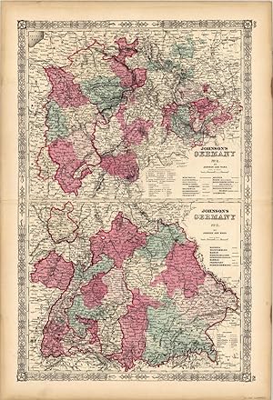
Johnsons Germany No. 2- Germany No. 3
Publication Date: 1863
Seller: Art Source International Inc., Boulder, CO, U.S.A.
Seller rating 5 out of 5 stars
 US$ 55.00 10% off
US$ 49.50
US$ 16.00 shipping
Ships within U.S.A.Quantity: 3 available
Add to basketThis antique map came from Johnsons New Illustrated (Steel Plate) Family Atlas, published in 1863, by Johnson and Ward. These maps are some of the most colorful andaccurate maps produced in the 1860's. Johnson maps are characterized by hand coloring in red and green and distinctive borders, including iron scrollwork and a Celticdesign. This beautiful double paged map has two distinct, detailed maps of Germany. This map shows the provinces, capitals, railroads, canals, villages and battle fieldsof Germany. This map measure 15.5 inches by 24.25 Inches.
-
Johnsons Germany No. 1
Publication Date: 1863
Seller: Art Source International Inc., Boulder, CO, U.S.A.
Seller rating 5 out of 5 stars
US$ 55.00 10% offUS$ 49.50
US$ 16.00 shipping
Ships within U.S.A.Quantity: 3 available
Add to basketThis antique map came from Johnson's New Illustrated (Steel Plate) Family Atlas, published in 1863, by Johnson and Ward. These maps are some of the most colorful and accurate maps produced in the 1860's. Johnson maps are characterized by hand coloring in red and green and distinctive borders, including iron scrollwork and a Celtic design. This beautiful map of Germany includes insets of Bremen and Hamburg. This map measure 15.5 inches by 12.5 Inches.
-
Johnsons Germany No. 1'
Publication Date: 1864
Seller: Art Source International Inc., Boulder, CO, U.S.A.
Seller rating 5 out of 5 stars
US$ 60.00 10% offUS$ 54.00
US$ 16.00 shipping
Ships within U.S.A.Quantity: 3 available
Add to basketNear the forefront of the atlas publication industry for a quarter century was mapmaker and aggressive marketer Alvin Jewitt Johnson. Around 1860, in a transaction that remains somewhat mysterious, Johnson acquired a set of detailed plates from J.H. Colton, one of the foremost mapmakers of the century, and used them to print the Johnson atlas that was to find its way into homes across the country. Johnsons New Illustrated Family Atlas was first published in 1860, and today these maps have become prized collectibles and true works of cartographic art. The attention to detail and fine hand coloring of these maps make them some of the best collectibles maps from the 19th century. This signal page map illustrates Germany, with inset maps of Hamburg and Bremen. Regions, cities, towns, rail roads, transportation routes and topographical features are noted. A very detailed and colorful map!' This map measure 15.5 inches by 13 Inches.
-
Johnson's Germany
Publication Date: 1865
Seller: Art Source International Inc., Boulder, CO, U.S.A.
Seller rating 5 out of 5 stars
US$ 60.00 10% offUS$ 54.00
US$ 16.00 shipping
Ships within U.S.A.Quantity: 3 available
Add to basketThis finely detailed map came from Johnson's New Illustrated (steel Plate) Family Atlas. Map shows cities and towns, rail lines, rivers and lakes, and wagon trails/roads. Each region is individually colored, and includes the traditional decorative border. Includes inset maps of Hamburg and Bremen. This map measure 15.5 inches by 12.5 Inches.
-
Johnson's Germany
Publication Date: 1860
Seller: Art Source International Inc., Boulder, CO, U.S.A.
Seller rating 5 out of 5 stars
First Edition
US$ 60.00 10% offUS$ 54.00
US$ 16.00 shipping
Ships within U.S.A.Quantity: 3 available
Add to basketThis map was issued as part of the extremely difficult to find Johnson's New Illustrated (Steel Plate) Family Atlas, With Descriptions, Geographical, Statisical, and Historical - Compiled, Drawn, and Engraved Under the Supervision of J.H. Colton and A.J. Johnson, T.B. Tilden. This is the first edition of this atlas by A.J. Johnson which was issued almost every year from 1860-1887. Johnson's Atlas "accurately reflects the expansion of our country, showing the growth of cities, towns and counties, as well as the emerging state boundaries in the west, and the development of the railroads nationwide." This map measure 15.5 inches by 12.5 Inches.
-
Johnsons Germany No.1'
Publication Date: 1862
Seller: Art Source International Inc., Boulder, CO, U.S.A.
Seller rating 5 out of 5 stars
US$ 65.00 10% offUS$ 58.50
US$ 16.00 shipping
Ships within U.S.A.Quantity: 3 available
Add to basketJohnson and Browning produced "Johnsons New Illustrated Steel Plate Family Atlas" in 1862. Germany is illustrated on this hand colored map. Insets show Bremen and Hamburg at greater detail. Regions are distinguished by bright pastel colors. Railroads, major roads, rivers, lakes, mountains, and the names of kingdoms, provinces, and important cities are identified. This map measure 15.25 inches by 12.5 Inches.
-
Johnsons Germany No.2 / Johnson's Germany No.3'
Publication Date: 1864
Seller: Art Source International Inc., Boulder, CO, U.S.A.
Seller rating 5 out of 5 stars
US$ 65.00 10% offUS$ 58.50
US$ 16.00 shipping
Ships within U.S.A.Quantity: 3 available
Add to basketNear the forefront of the atlas publication industry for a quartercentury was mapmaker and aggressive marketer Alvin Jewitt Johnson. Around 1860, in a transaction that remains somewhat mysterious, Johnson acquired a set of detailed plates from J.H. Colton, one of the foremost mapmakers of the century, and used them to print the Johnson atlas that was to find its way into homes across the country. Johnsons New Illustrated Family Atlas was first published in 1860, and today these maps have become prized collectibles and true works of cartographic art. The attention to detail and fine hand coloring of these maps make them some of the best collectibles maps from the 19th century. This double page map illustrates Germany, provinces, kingdoms, principalities, cities, towns, villages, battle fields, rail roads, common roads and canals are noted. This map measure 17 inches by 23 Inches.
-
Johnsons Germany No.2 -Johnson's Germany No.3'
Publication Date: 1862
Seller: Art Source International Inc., Boulder, CO, U.S.A.
Seller rating 5 out of 5 stars
US$ 65.00 10% offUS$ 58.50
US$ 16.00 shipping
Ships within U.S.A.Quantity: 3 available
Add to basketJohnson and Browning produced this steel plate, hand colored map for "Johnsons New Illustrated Family Atlas" in 1862. Germany is illustrated on two maps on this detailed, double page map. Regions are distinguished by bright pastel colors. Other details include lakes, rivers, mountains, railroads, major roads, and the names of countries, regions and important cities. This map measure 15.5 inches by 24 Inches.
-
Johnsons Germany No.2 / Johnson's Germany No.3'
Publication Date: 1865
Seller: Art Source International Inc., Boulder, CO, U.S.A.
Seller rating 5 out of 5 stars
US$ 65.00 10% offUS$ 58.50
US$ 16.00 shipping
Ships within U.S.A.Quantity: 3 available
Add to baskethis antique map came from Johnson's New Illustrated (Steel Plate) Family Atlas, published in 1865, by Johnson and Browning. These maps are some of the most colorful and accurate maps produced in the 1860's. Johnson maps are characterized by hand coloring in red and green and distinctive borders, including iron scrollwork and a Celtic design. This beautiful double paged map has two distinct, detailed maps of Germany. This map shows the provinces, capitals, railroads, canals, villages and battle fields of Germany. This map measure 16 inches by 24 Inches.
-
Johnsons Germany'
Publication Date: 1866
Seller: Art Source International Inc., Boulder, CO, U.S.A.
Seller rating 5 out of 5 stars
US$ 65.00 10% offUS$ 58.50
US$ 16.00 shipping
Ships within U.S.A.Quantity: 1 available
Add to basketNear the forefront of the atlas publication industry for a quarter century was mapmaker and aggressive marketer Alvin Jewitt Johnson. Around 1860, in a transaction that remains somewhat mysterious, Johnson acquired a set of detailed plates from J.H. Colton, one of the foremost mapmakers of the century, and used them to print the Johnson atlas that was to find its way into homes across the country. Johnsons New Illustrated Family Atlas was first published in 1860, and today these maps have become prized collectibles and true works of cartographic art. The attention to detail and fine hand coloring of these maps make them some of the best collectibles maps from the 19th century. This map measure 17 inches by 23 Inches.
-
Johnsons Germany'
Publication Date: 1861
Seller: Art Source International Inc., Boulder, CO, U.S.A.
Seller rating 5 out of 5 stars
US$ 70.00 10% offUS$ 63.00
US$ 16.00 shipping
Ships within U.S.A.Quantity: 3 available
Add to basketThis colorful map came from Johnsons New Illustrated (steel plate) Family Atlas. Includes the the characteristic iron scrollwork decorative border. Shows railroads, common roads, canals, townships, villages, and battle fields. This map is in great condition, and would look nice framed! This is two maps in one--double page. This map measure 15.5 inches by 24 Inches.
-
Johnsons Germany'
Publication Date: 1861
Seller: Art Source International Inc., Boulder, CO, U.S.A.
Seller rating 5 out of 5 stars
US$ 70.00 10% offUS$ 63.00
US$ 16.00 shipping
Ships within U.S.A.Quantity: 3 available
Add to basketThis colorful map came from Johnsons New Illustrated (steel plate) Family Atlas. Includes the the characteristic iron scrollwork decorative border. Shows railroads, common roads, canals, townships, villages, and battle fields. This map is in great condition, and would look nice framed! Also has nice inset of Hamburg and Bremen. This map measure 15.5 inches by 12.5 Inches.
-
Johnson's Germany (Double Page)
Publication Date: 1860
Seller: Art Source International Inc., Boulder, CO, U.S.A.
Seller rating 5 out of 5 stars
First Edition
US$ 75.00 10% offUS$ 67.50
US$ 16.00 shipping
Ships within U.S.A.Quantity: 3 available
Add to basketThis map was issued as part of the extremely difficult to find Johnson's New Illustrated (Steel Plate) Family Atlas, With Descriptions, Geographical, Statisical, and Historical - Compiled, Drawn, and Engraved Under the Supervision of J.H. Colton and A.J. Johnson, T.B. Tilden. This is the first edition of this atlas by A.J. Johnson which was issued almost every year from 1860-1887. Johnson's Atlas "accurately reflects the expansion of our country, showing the growth of cities, towns and counties, as well as the emerging state boundaries in the west, and the development of the railroads nationwide." This map measure 15.5 inches by 24 Inches.
-
Johnsons Prussia and Germany'
Publication Date: 1867
Seller: Art Source International Inc., Boulder, CO, U.S.A.
Seller rating 5 out of 5 stars
US$ 80.00 10% offUS$ 72.00
US$ 16.00 shipping
Ships within U.S.A.Quantity: 1 available
Add to basketThis antique map came from Johnson's New Illustrated (Steel Plate) Family Atlas, published in 1867, by A.J. Johnson. These maps are some of the most colorful and accurate maps produced in the 1860's, their attention to detail and the fine steel engraving make them works of art. Johnson maps are characterized by hand coloring in red, green, yellow, and pink and distinctive borders, including iron scrollwork and a Celtic design. This beautiful map of Prussia and Germany shows countries, states and or provinces and regions, cities and towns, lakes, rivers, and water bodies, railroads, forts, and wagon trails. A fine piece that would make a nice addition to any wall in a home or office. Includes an inset map of Northeastern Prussia. This map measure 16.5 inches by 23 Inches.
-

Johnson's Germany No. I, (79.) - Teilkolorierte Karte im Stahlstich
Seller: Celler Versandantiquariat, Eicklingen, Germany
Association Member: GIAQ
Seller rating 5 out of 5 stars
Johnson and Ward, (1863). Blattma�: ca. 46,2 x 35,3 cm, unten links kleine Karte von Hamburg, unten rechts kleine Karte von Bremen, mit dekorativer Bord�re, (r�ckseitig eingedruckter Text/teils gering fleckig/breiter Blattrand mit kleinem Einri�)---- Karte von Norddeutschland: Hannover (Kingdom), Hamburg, L�beck, Bremen, Oldenburg, Holstein, Lauenburg, Anhalt (Dessau, Bernberg & Kothen), Mecklenburg (Schwerin & Strelitz), Lippe Detmold, Schaumburg - 20 Gramm.
-

Johnson's Germany No.2. Johnson's Germany No. 3.
Publication Date: 1861
Seller: Geographicus Rare Antique Maps, Brooklyn, NY, U.S.A.
Association Member: ABAA ESA ILAB
Seller rating 4 out of 5 stars

Map
Very good. Typical wear and toning along original centerfold. Minor foxing. Size 25 x 17 Inches. This is a beautiful example of the western sheets from A. J. Johnson and R. Browning's 1861 Germany series. The map is divided into two separate maps within the same border. The upper map depicts the states of Westphalia, Clevesberg (Rhein Provinces), Hessen Cassel Darmstadt, Brunswick, Schwarzburg, Frankfurt, Waldeck, Reuss, Saxen Coburg Gotha Meiningen, Saxen Altenburg, Weimar and Luxemburg. The lower map focuses on Bavaria, Wurtenburg, Baden, Frankfurt and Hessen Homburg. Depicting the large and awkward range of the German Confederation has always been a challenge for Johnson. This is one of Johnson's earliest attempts, dividing the region into four separate maps, Germany 1, 2, and 3, and a separate Prussia sheet. Various towns, cities, railways, rivers and several other topographical features are noted with relief shown by hachure. It features the strapwork style border common to Johnson's atlas work from 1860 to 1863. Published by A. J. Johnson and Browning as plate nos. 75 and 76 in the 1861 edition of Johnson's New Illustrated Family Atlas . This is the last edition of the Johnson Atlas to bear the 'Johnson and Browning' imprint. Subsequent editions reflect Ward's 1862 acquisition Ross C. Browning's shares in the firm.
-

Johnson's Germany No. 2. Johnson's Germany No. 3.
Publication Date: 1863
Seller: Geographicus Rare Antique Maps, Brooklyn, NY, U.S.A.
Association Member: ABAA ESA ILAB
Seller rating 3 out of 5 stars

Map
Very good. Minor wear along original centerfold. Text on verso. Size 24 x 18 Inches. This is a beautiful example of the western sheets from Johnson and Ward's 1863 Germany series. The map is divided into two separate maps within the same border. The upper map depicts the states of Westphalia, Clevesberg (Rhein Provinces), Hessen Cassel Darmstadt, Brunswick, Schwarzburg, Frankfurt, Waldeck, Reuss, Saxen Coburg Gotha Meiningen, Saxen Altenburg, Weimar and Luxemburg. The lower map focuses on Bavaria, Wurtenburg, Baden, Frankfurt and Hessen Homburg. Depicting the large and award range of the German Confederation has always been a challenge for Johnson. This is one of Johnson's earliest attempts, dividing the region into four separate maps, Germany 1, 2, and 3, and a separate Prussia sheet. Various towns, cities, railways, rivers and several other topographical features are noted with relief shown by hachure. Features the fretwork style border common to Johnson's atlas work from 1863 to 1869. Published by Johnson and Ward as plate nos. 80-81 in the scarce 1863 edition of Johnson's Family Atlas . This is the second edition of the Johnson atlas to bear the Johnson and Ward imprint. References: Rumsey 0352.056 (1864 edition). Philips (atlases) 843.
-

Johnson's Germany, No. 2. Johnson's Germany, No. 3.
Publication Date: 1864
Seller: Geographicus Rare Antique Maps, Brooklyn, NY, U.S.A.
Association Member: ABAA ESA ILAB
Seller rating 3 out of 5 stars
Map First Edition
Very good. Text on verso. Minor wear along original centerfold. Verso repair near top border. Light overall toning. Size 17 x 25 Inches. This is a beautiful example of the western sheets from Johnson and Ward's 1864 Germany series. The map is divided into two separate maps within the same border. The upper map depicts the states of Westphalia, Clevesberg (Rhein Provinces), Hessen Cassel Darmstadt, Brunswick, Schwarzburg, Frankfurt, Waldeck, Reuss, Saxen Coburg Gotha Meiningen, Saxen Altenburg, Weimar and Luxemburg. The lower map focuses on Bavaria, Wurtenburg, Baden, Frankfurt and Hessen Homburg. Depicting the large and award range of the German Confederation has always been a challenge for Johnson. This is one of Johnson's earliest attempts, dividing the region into four separate maps, Germany 1, 2, and 3, and a separate Prussia sheet. Various towns, cities, railways, rivers and several other topographical features are noted with relief shown by hachure. It features the fretwork style border common to Johnson's atlas work from 1863 to 1869. Steel plate engraving prepared by A. J. Johnson for publication as plate nos. 85 and 86 in the 1864 edition of his New Illustrated Atlas . This is the first edition of the Johnson'sAtlasto bear the Johnson & Ward imprint and the only edition to identify the firm as the 'Successors to Johnson and Browning (Successors to J. H. Colton and Company). References: Rumsey 0352.056. Philips (atlases) 843.
-

Johnson's Germany No.2. / Johnson's Germany No. 3.
Publication Date: 1862
Seller: Geographicus Rare Antique Maps, Brooklyn, NY, U.S.A.
Association Member: ABAA ESA ILAB
Seller rating 3 out of 5 stars
Map
Very good condition. Blank on verso. Minor verso reinforcement along original centerfold. Size 24 x 16 Inches. This is A. J. Johnson and Ward's 1862 map of western Germany. Divided into two separate maps. The upper map depicts the states of Westphalia, Clevesberg (Rhein Provinces), Hessen Cassel Darmstadt, Brunswick, Schwarzburg, Frankfurt, Waldeck, Reuss, Saxen Coburg Gotha Meiningen, Saxen Altenburg, Weimar and Luxemburg. The lower map focuses on Bavaria, Wurtenburg, Baden, Frankfurt and Hessen Homburg. Depicting the large and award region of the German Confederation has always been a challenge for Johnson. This is one of Johnson's earliest attempts, dividing the region into four separate maps, Germany 1, 2, and 3, and a separate Prussia sheet. Features the strapwork border common to Johnson's atlas work from 1860 to 1863. Steel plate engraving prepared by A. J. Johnson for publication as page nos.
-

Johnson's Germany No. 1.
Publication Date: 1861
Seller: Geographicus Rare Antique Maps, Brooklyn, NY, U.S.A.
Association Member: ABAA ESA ILAB
Seller rating 3 out of 5 stars
Map
Very good. Blank on verso. Minor overall toning. Size 13.5 x 16 Inches. This is a beautiful example of the northern sheet from A. J. Johnson and R. Browning's 1861 Germany series. Details the regions of Hanover, Mecklenburg Schwerin, Holstein and Oldenburg, with inset detail plans of Hamburg and Bremen. The map is color coded according to district. Depicting the large and awkward range of the German Confederation has always been a challenge for Johnson. This is one of Johnson's earliest attempts, dividing the region into four separate maps, Germany 1, 2, and 3, and a separate Prussia sheet. Various towns, cities, railways, rivers and several other topographical features are noted with relief shown by hachure. This map features the strapwork style border common to Johnson's atlas work from 1860 to 1863. Published by A. J. Johnson and Browning as plate no. 74 in the 1861 edition of Johnson's New Illustrated Family Atlas . This is the last edition of the Johnson Atlas to bear the 'Johnson and Browning' imprint. Subsequent editions reflect Ward's 1862 acquisition Ross C. Browning's shares in the firm.
-

Johnson's Germany No. 1.
Publication Date: 1862
Seller: Geographicus Rare Antique Maps, Brooklyn, NY, U.S.A.
Association Member: ABAA ESA ILAB
Seller rating 3 out of 5 stars
Map First Edition
Very good condition. Light overall toning. Size 12.5 x 16 Inches. A very beautiful example of the northern sheet from Johnson's Germany series. Details Hanover, Mecklenburg Schwerin, Holstein and Oldenburg. Insets detail the city of Hamburg and the city of Bremen. Color coded according district. Shows railways, lakes, rivers and towns. Features the strapwork style border common to Johnson's atlas work from 1860 to 1863. Published by A. J. Johnson and Ward as plate number 79 in the 1862 edition of Johnson's New Illustrated Family Atlas . This is the first edition of the Family Atlas to bear the Johnson and Ward imprint.