Order Total (1 Item Items):
Shipping Destination:

Kingdoms Divided, First Edition (3 results)
Skip to main search results
Search filters
Product Type
- All Product Types
- Books (3)
- Magazines & Periodicals (No further results match this refinement)
- Comics (No further results match this refinement)
- Sheet Music (No further results match this refinement)
- Art, Prints & Posters (No further results match this refinement)
- Photographs (No further results match this refinement)
- Maps (No further results match this refinement)
- Manuscripts & Paper Collectibles (No further results match this refinement)
Condition Learn more
- New (No further results match this refinement)
- As New, Fine or Near Fine (No further results match this refinement)
- Very Good or Good (2)
- Fair or Poor (No further results match this refinement)
- As Described (1)
Binding
- All Bindings
- Hardcover (2)
- Softcover (No further results match this refinement)
Collectible Attributes
- First Edition (3)
- Signed (No further results match this refinement)
- Dust Jacket (No further results match this refinement)
- Seller-Supplied Images (3)
- Not Print on Demand (3)
Language (1)
Price
- Any Price
- Under US$ 25 (No further results match this refinement)
- US$ 25 to US$ 50 (No further results match this refinement)
- Over US$ 50
Free Shipping
- Free Shipping to U.S.A. (No further results match this refinement)
Seller Location
Seller Rating
-
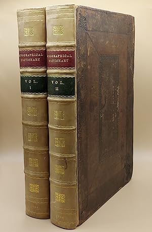
A New Geographical Dictionary. Containing a Full and Accurate Account of the Several Parts of the Known World, As it is Divided into Continents, Islands, Oceans, Seas, Rivers, Lakes, &c. The Situation, Extent, and Boundaries, of all the Empires, Kingdoms, States, Provinces, &c. in Europe, Asia, Africa, and America. Together with The Religion, Learning, Policy, Manners, and Customs, of the Inhabitants. To which is prefixed, An Introductory Dissertation, Explaining The Figure and Motion of the Earth, the Use of the Globes, and Doctrine of the Sphere, in order to render the Science of Geography easy and intelligible to the meanest Capacity (2 volumes)
Published by Printed for J. Coote, London, 1760
Seller: Ken Sanders Rare Books, ABAA, Salt Lake City, UT, U.S.A.
Association Member: ABAA ILAB IOBA RMABA
Seller rating 5 out of 5 stars

First Edition
Leather bound. Condition: Very Good. First edition. Folio [36.5 cm] Original dark brown decoratively embossed leather boards, rebacked with gilt-stamped calf spines in seven compartments. Red and green leather spine labels. Title pages printed in red and black. Text in double columns. Both vertical and horizontal chain lines. Restoration to the boards at corners and near head of spine. Boards rubbed and slightly mottled. Small bite to top fore-edge corner of each title page. Numerical notation in contemporary pen written twice on title page of Volume 1. A handful of the pages have minor open and closed tears. One brief manuscript notation within the text. Internally, very fresh. With a frontis, 99 plates, 37 maps, and 8 plans. An 18th century geographical dictionary, which includes a dissertation on the figure and motion of the earth, in addition to the presentation of facts about dress and customs of various lands. Quite readable and lavishly illustrated. Includes a number of maps, "with improvements" and decorative cartouches, from the "Sieur Robert's Atlas" series such as, "An Accurate Map of Africa," "An Accurate Map of North America" (The British colonies extend to the Mississippi), "The East Indies; distinguishing the Empires and Kingdoms on the Continent commonly call'd India," "A New and Accurate Map of the Kingdom of Prussia and Polish Prussia," and "An Accurate Map of the Marquisate of Moravia." Among the charmingly detailed plates included, are "A Young Lady of Aleppo smoking Tobacco, and her Servant bringing her a Dish of Coffee," "The East Entrance to the Temple of the Sun, in Palmira," "A View of Florence on the Side of the Arno, and Trinity Bridge," "Habit of an English Lady of Quality in 1588," "A Chinese Mandarin in a Summer Habit," and "Habit of a Sclavonian." John Barrow was a geographer, historian, and lexicographer. He was originally a teacher of mathematics and navigation aboard ships of the Royal Navy. He retired in 1750 and turned his attention entirely towards writing. Elizabeth Baigent writes, in her entry for the "Oxford Dictionary of National Biography," "He compiled dictionaries and other works which drew on his mathematical and scientific knowledge. Many of his works went through more than one edition and some were translated. His compilations included 'Dictionarium polygraphicum' (1735), 'Dictionarium medicum, universale' (1749), a 'Geographical Dictionary' (2 vols, 1759-60), and 'Dictionary of Arts and Sciences' (1764)." Barrow published this work, his geographical dictionary, anonymously in London. A visually pleasing work of geographical reference.
-
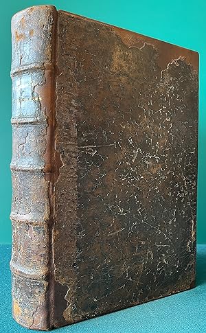
THE SIX VOYAGES OF JOHN BAPTISTA TAVERNIER bound with A COLLECTION OF SEVERAL RELATIONS & TREATISES SINGULAR AND CURIOUS, OF JOHN BAPTISTA TAVERNIER, BARON OF AUBONNE. Not Printed among his first Six Voyages (Two Volumes bound as One) Vol. I: The Six Voyages of John Baptista Tavernier, a Noble Man of France now living, through Turky into Persia, and the East-Indies, Finished in the Year 1670. Giving an Account of the State of those Countries. Illustrated with divers Sculptures. Together with a New Relation of the present Grand Seignor's Seraglio, by the same Author. Made English by J. P. To which is added a Description of all the Kingdoms which Encompass the Euxine and Caspian Seas. By an English Traveller, never before Printed. Vol. II: A COLLECTION OF SEVERAL. Divided into Five Parts, viz. I. A new and singular Relation of the Kingdom of Tunquin, with several Figures, and a Map of the Countrey. II. How the Hollanders manage their Affairs in Asia. III. A Relation of Japon, and the Cau
Published by London Vol. I: Printed for R.[obert] L.[ittlbury] and M.[oses] P.[itt] and are to be sold by John Starkey at the Miter in Fleet-Street, near Temple Bar, and Moses Pitt at the Angel in St. Paul's Church-Yard. Vol. II: Published by Edmund Everard, Esquire. Printed by A. Godbid and J. Playford, for Moses Pitt at the Angel in St. Paul's Church-Yard. 1678 and 1680, 1680
Seller: Chaucer Bookshop ABA ILAB, Canterbury, United Kingdom
Seller rating 5 out of 5 stars
First Edition
US$ 4,764.06
US$ 33.52 shipping
Ships from United Kingdom to U.S.A.Quantity: 1 available
Add to basketFIRST ENGLISH EDITION. Two Volumes bound as one. Folio (approx. 32 x 21.5cm) Full contemporary calf, professionally rebacked, with original spine and upper board laid on. Five raised bands and dark brown title label, gilt, to spine. New endpapers. Volume I in four parts: Part 1: [2],2,[18],264 [Pages 185-198 incorrectly numbered as 195-208; pp 200-254 incorrectly numbered as 210-264. All plates present. Pp 39-42 missing, neatly cut out.); Part 2: [2],214 (p15 misnumbered 51 and p63 as 61). All plates present. Pages 145-60 missing, appear to have never been bound in. Gatherings *U*V*W*X = 16pp); Parts 3 and 4: [6],97,[8],107-119,[3] including Publisher's List. Volume I contains 24 full-page engraved plates (1 folding), illustrating Parts 1 and 2. Volume II in five parts: Part 1 (Tunquin): [20],54,[2] (pp. 49-50 missing (cut out). Part 2 (Formosa): 57-87[1]; Part 3 (Japan): 25; Part 4 (Persia and the Indies): 26-50 (p39 misnumbered 93); Part 5 (East-Indies): 51-66,[2] including Publisher's List. Volume II contains 6 full page engraved plates with 6 accompanying pages of captions, plus a large folding map of Japan with an inset map of Tunquin. Title page has an old, faded ink signature to top corner and some initials further down. No other markings or inscriptions. Many page corners and edges have been professionally strengthened where there was some loss. Three of the plates in Volume I have closed tears (repaired) and the large folding Map of Japan in Volume II has a large closed tear (repaired) and has had the lower outer corner professionally repaired where ther has been some loss - please see photos. As to be expected, there is some browning to page edges, handling marks and old staining to lower outer corner of last half of the book. First few pages, including title page. have a slight scorch mark to upper inner corner. Overall A GOOD COPY, expertly repaired, of a scarce single volume of Tavernier's travels with its fascinating engravings. The 'Mapp of the Isles of Iapon' is the first English edition of Tavernier's map of Japan, first published the previous year, augmented with an inset of the Gulf of Tonkin, originally a separate map in the original work. The route by land & sea from Nagasaki to Tokyo is marked. On stylistic grounds the map has been attributed to the engraver Herman Moll, making it one of his earliest works. Tavernier, a gem merchant, travelled only to China, but included a description of Japan in his account. (Shelf 9) PLEASE NOTE: VERY Heavy Book (2.6 kg+) Postage outside the UK will incur a surcharge. Buyer is responsible for any additional duties, taxes, or fees required by recipient's country.** Pictures available upon request.** Visit our homepage for our shop opening hours. Over 20,000 books in stock - come and browse. PayPal, credit and most debit cards welcome. Books posted worldwide. For any queries please contact us direct.
-
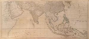
Asia According to the Sieur d'Anville, Divided into its Empires, Kingdoms & States
Published by Robert Sayer, London, 1772
Seller: William Chrisant & Sons, ABAA, ILAB. IOBA, ABA, Ephemera Society, Fort Lauderdale, FL, U.S.A.
Association Member: ABAA ESA ILAB
Seller rating 5 out of 5 stars
First Edition
Condition: Very Good. First Edition. Southern part only. Paper measures 21 3/4 inches by 48 1/2 inches. Two maps joined together with three fold lines. Scarce.