Order Total (1 Item Items):
Shipping Destination:

Kingdoms Divided, Used (53 results)
Skip to main search results
Search filters
Product Type
- All Product Types
- Books (34)
- Magazines & Periodicals (No further results match this refinement)
- Comics (No further results match this refinement)
- Sheet Music (No further results match this refinement)
- Art, Prints & Posters (2)
- Photographs (No further results match this refinement)
- Maps (17)
- Manuscripts & Paper Collectibles (No further results match this refinement)
Condition Learn more
- New (No further results match this refinement)
- As New, Fine or Near Fine (14)
- Very Good or Good (14)
- Fair or Poor (1)
- As Described (24)
Binding
Collectible Attributes
- First Edition (3)
- Signed (No further results match this refinement)
- Dust Jacket (No further results match this refinement)
- Seller-Supplied Images (36)
- Not Print on Demand (53)
Language (3)
Free Shipping
Seller Location
Seller Rating
-

Paperback. Condition: Fair. No Jacket. Readable copy. Pages may have considerable notes/highlighting. ~ ThriftBooks: Read More, Spend Less.
-

Daniel 11 And The Medieval Divided Kingdoms
Language: English
Published by Teach Services, Inc., 2021
ISBN 10: 1479613312 ISBN 13: 9781479613311
Condition: As New. Unread book in perfect condition.
-

Condition: As New. Unread book in perfect condition.
-

Daniel 11 and the Medieval Divided Kingdoms: The Struggle between Rome and Constantinople for Church-State Supremacy
Language: English
Published by Teach Services, Inc., 2021
ISBN 10: 1479616265 ISBN 13: 9781479616268
Condition: As New. Unread book in perfect condition.
-

A general system of nature, through the three grand kingdoms of animals, vegetables, and minerals, Systematically Divided into their several classes,
Seller: GreatBookPricesUK, Woodford Green, United Kingdom
Seller rating 5 out of 5 stars

US$ 35.25
US$ 20.11 shipping
Ships from United Kingdom to U.S.A.Quantity: Over 20 available
Add to basketCondition: As New. Unread book in perfect condition.
-
Daniel 11 And The Medieval Divided Kingdoms
Language: English
Published by Teach Services, Inc., 2021
ISBN 10: 1479613312 ISBN 13: 9781479613311
Seller: GreatBookPricesUK, Woodford Green, United Kingdom
Seller rating 5 out of 5 stars
US$ 35.52
US$ 20.11 shipping
Ships from United Kingdom to U.S.A.Quantity: Over 20 available
Add to basketCondition: As New. Unread book in perfect condition.
-
Daniel 11 and the Medieval Divided Kingdoms: The Struggle between Rome and Constantinople for Church-State Supremacy
Language: English
Published by Teach Services, Inc., 2021
ISBN 10: 1479616265 ISBN 13: 9781479616268
Seller: GreatBookPricesUK, Woodford Green, United Kingdom
Seller rating 5 out of 5 stars
US$ 47.06
US$ 20.11 shipping
Ships from United Kingdom to U.S.A.Quantity: Over 20 available
Add to basketCondition: As New. Unread book in perfect condition.
-

DIVIDED KINGDOMS: THE IRON AGE GOLD COINAGE OF SOUTHERN ENGLAND.
Language: English
Published by Aylsham, Norfolk: Chris Rudd, 2017., 2017
ISBN 10: 0956688934 ISBN 13: 9780956688934
Seller: Minster Gate Bookshop (est. 1970), YORK, United Kingdom
Association Member: PBFA
Seller rating 5 out of 5 stars
US$ 103.57
US$ 24.80 shipping
Ships from United Kingdom to U.S.A.Quantity: 1 available
Add to basketCondition: Fine. 4to., pp.xiv,811, navy cloth, gilt, 164 b/w figures, 87 b/w maps; a fine copy. No dust-jacket, as issued. (An extremely heavy volume, for which an additional postage charge will be required).
-

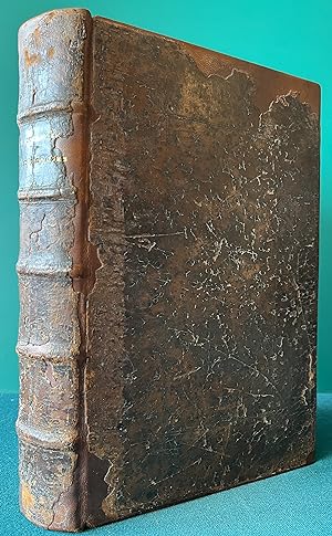
Condition: Hervorragend. Zustand: Hervorragend | Seiten: 732 | Sprache: Englisch | Produktart: B�cher | Keine Beschreibung verf�gbar.
-
Daniel 11 and the Medieval Divided Kingdoms : The Struggle between Rome and Constantinople for Church-State Supremacy
Language: English
Published by TEACH Services, Inc., 2021
ISBN 10: 1479613312 ISBN 13: 9781479613311
Condition: Sehr gut. Zustand: Sehr gut | Sprache: Englisch | Produktart: B�cher | Doctor Perry Louden puts his money where his mouth is when he proposes a new logical, instructive, and chronological take on Daniel 11. In his own words, "This position is by no means meant to be the end-all to our study and dialogue on Daniel 11.The result must be to put an end to our vacillation among a multitude of positions and opinions in Daniel 11." Doctor Louden confronts years of indecision by using principles of interpretation consistent with Adventist theological history. He extends this consistency to questionable verses in Daniel 11, long since debated in Adventism. His chronological approach helps make Daniel 11 easier to follow. Though Louden may not explicitly state who the King of the South is today, he does lay the necessary historical foundation that all--theologians and Bible students alike--need to arrive at the answers to questions that have long been obscured. "We are in the Toenails of Daniel's Image, and we must present all Daniel's prophecies with the same power and exuberance of those giving the message of hope in the judgment before October 22, 1844.".
-
Condition: Sehr gut. Zustand: Sehr gut | Seiten: 902 | Sprache: Englisch | Produktart: B�cher | Keine Beschreibung verf�gbar.
-
Condition: Gut. Zustand: Gut | Seiten: 962 | Sprache: Englisch | Produktart: B�cher | Keine Beschreibung verf�gbar.
-

Close-up of the 5000 years of China: A period of confusion when many military rulers divided their territory. The Three Kingdoms of the Later Han Dynasty Volume 3 (A.D. 25-280)
Published by Sekaibunkasha, 1996
ISBN 10: 4418962182 ISBN 13: 9784418962181
Condition: Fine. Number of pages: 167p Size: 31cm.
-
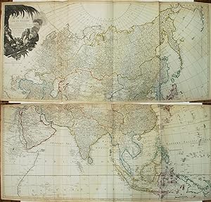
Asia and its Islands According to d'Anville; Divided into Empires, Kingdoms, States, Regions, etc.
Language: English
Published by Laurie & Whittle, London, 1794
Seller: Argosy Book Store, ABAA, ILAB, New York, NY, U.S.A.
Seller rating 5 out of 5 stars
unbound. Map. Engraving with hand coloring. Together measure 42" x 48". This informative late 18th-century wall map of Asia is based on the cartography of the famous French cartographer Jean Baptiste Bourguignon D'Anville. He was particularly interested in the Far East, making exact studies from many sources, and including the excellent contributions made by Jesuit missionaries to China and Indonesia. It is interesting to note the Asiatic royal leader in the cartouche with an opium pipe, for it was at this time that the export of opium to China from India began. The cartouche also illustrates other items of trade: cotton and silk, spices, and tea and a cute camel. Historical and geographical notes throughout identifies cities, caravan routes, undersea shoals, rivers, lakes, islands and topography. In East Asia, the discoveries of the Russians and Dutch are noted, including those of Bering (Behring Island, where he died includes a note "where he was cast away and died in 1741"). Central Asia, which was more or less unmapped at the time, shows interesting detail. The supposed "ancient seat of the Monguls Empire" is identified. The Straits of Singapore are labeled. Singapore Island, although not identified, is noted. It was published by Laurie and Whittle in Thomas Kitchin's "General Atlas". The sheets are in good condition with overall toning and some foxing at places. Minor wear along the folds and some edge wear. Thomas Kitchin (1719-1784) was an English engraver and map-maker. His maps and atlases of England earned him the position of hydrographer to the King. Kitchin produced many maps for The London Magazine which was founded in 1732 and is still published today. Robert Laurie (c. 1755 - 1836) and James Whittle (1757-1818) were London-based map and atlas publishers active in the late 18th and early 19th century. Their firm combined Laurie's engraving skills with Whittle's social contacts and print sales experience. Together, they published numerous maps and atlases, often enlisting prominent cartographers such as Kitchin, Faden, Jefferys and others to update and modify their plates. Jean Baptiste Bourguignon d' Anville (1697-1782) was a French geographer and cartographer whose accurate, research-based work raised the standards for 18th-century map-making. Passionate about maps from his childhood, he created maps during his school years and would go on to publish several atlases during his prolific career. In his early 20's he became the Geographer to the King of France. His accuracy and in depth research would make him one of the most important cartographers of the 18th century.
-
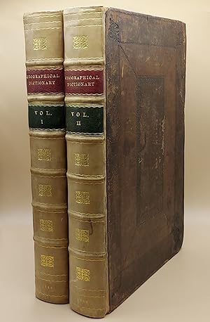
A New Geographical Dictionary. Containing a Full and Accurate Account of the Several Parts of the Known World, As it is Divided into Continents, Islands, Oceans, Seas, Rivers, Lakes, &c. The Situation, Extent, and Boundaries, of all the Empires, Kingdoms, States, Provinces, &c. in Europe, Asia, Africa, and America. Together with The Religion, Learning, Policy, Manners, and Customs, of the Inhabitants. To which is prefixed, An Introductory Dissertation, Explaining The Figure and Motion of the Earth, the Use of the Globes, and Doctrine of the Sphere, in order to render the Science of Geography easy and intelligible to the meanest Capacity (2 volumes)
Published by Printed for J. Coote, London, 1760
Seller: Ken Sanders Rare Books, ABAA, Salt Lake City, UT, U.S.A.
Association Member: ABAA ILAB IOBA RMABA
Seller rating 5 out of 5 stars
First Edition
Leather bound. Condition: Very Good. First edition. Folio [36.5 cm] Original dark brown decoratively embossed leather boards, rebacked with gilt-stamped calf spines in seven compartments. Red and green leather spine labels. Title pages printed in red and black. Text in double columns. Both vertical and horizontal chain lines. Restoration to the boards at corners and near head of spine. Boards rubbed and slightly mottled. Small bite to top fore-edge corner of each title page. Numerical notation in contemporary pen written twice on title page of Volume 1. A handful of the pages have minor open and closed tears. One brief manuscript notation within the text. Internally, very fresh. With a frontis, 99 plates, 37 maps, and 8 plans. An 18th century geographical dictionary, which includes a dissertation on the figure and motion of the earth, in addition to the presentation of facts about dress and customs of various lands. Quite readable and lavishly illustrated. Includes a number of maps, "with improvements" and decorative cartouches, from the "Sieur Robert's Atlas" series such as, "An Accurate Map of Africa," "An Accurate Map of North America" (The British colonies extend to the Mississippi), "The East Indies; distinguishing the Empires and Kingdoms on the Continent commonly call'd India," "A New and Accurate Map of the Kingdom of Prussia and Polish Prussia," and "An Accurate Map of the Marquisate of Moravia." Among the charmingly detailed plates included, are "A Young Lady of Aleppo smoking Tobacco, and her Servant bringing her a Dish of Coffee," "The East Entrance to the Temple of the Sun, in Palmira," "A View of Florence on the Side of the Arno, and Trinity Bridge," "Habit of an English Lady of Quality in 1588," "A Chinese Mandarin in a Summer Habit," and "Habit of a Sclavonian." John Barrow was a geographer, historian, and lexicographer. He was originally a teacher of mathematics and navigation aboard ships of the Royal Navy. He retired in 1750 and turned his attention entirely towards writing. Elizabeth Baigent writes, in her entry for the "Oxford Dictionary of National Biography," "He compiled dictionaries and other works which drew on his mathematical and scientific knowledge. Many of his works went through more than one edition and some were translated. His compilations included 'Dictionarium polygraphicum' (1735), 'Dictionarium medicum, universale' (1749), a 'Geographical Dictionary' (2 vols, 1759-60), and 'Dictionary of Arts and Sciences' (1764)." Barrow published this work, his geographical dictionary, anonymously in London. A visually pleasing work of geographical reference.
-
The Geographical Magazine; Or, A New, Copious, Compleat, and Universal System of Geography. Containing An accurate and entertaining Account and Description of the several Continents, Islands, Peninsulas, Isthmuses, Capes, Promontories, Lakes, Rivers, Seas, Oceans, Gulphs, and Bays, of Asia, Africa, Europe, and America; Divided Into Empires, Kingdoms, States, and Colonies; etc. etc. The Literature, Arts, Sciences, Trade, Manufactures, and Commerce. Etc. etc. To which are prefixed, An Introductory Treatise on the Sciences of GEOGRAPHY and ASTRONOMY; and their Relation to each other: A New and Familiar Guide to the Use of the Celestial and Terrestrial Globes.
Published by Printed for Harrison and Co. London Vol. II only of 2. Small folio, 1783
Seller: Patrick Pollak Rare Books ABA ILAB, SOUTH BRENT, DEVON, United Kingdom
Seller rating 3 out of 5 stars

US$ 1,657.15
US$ 33.52 shipping
Ships from United Kingdom to U.S.A.Quantity: 1 available
Add to basketpp. vi, 608, (i) Address to the Public, (i) Maps and Plates. Frontispiece, 23 folding engraved maps by J. BAYLY, 19 engraved plates. Contemporary calf, marbled end-papers, boards rubbed, worn and detached, the title creased vertically, foxed and dusty in the margins, old and faded damping in the inner margins of the last few gatherings including 3 maps and a plate, overall text, maps and plates all clean and in good order. *The section on America, North and South, occupies pages 451 to 534, with 2 maps and a plate of the Niagara Falls; it covers CANADA - NEW ENGLAND - NEW JERSEY - PENNSYLVANIA - MARYLAND - VIRGINIA - NORTH & SOUTH CAROLINA - GEORGIA - FLORIDA, CALIFORNIA - NEW & OLD MEXICO - SPANISH & PORTUGUESE AMERICA including BRAZIL, PERU, CHILI, PARAGUAY, PATAGONIA.
-
THE SIX VOYAGES OF JOHN BAPTISTA TAVERNIER bound with A COLLECTION OF SEVERAL RELATIONS & TREATISES SINGULAR AND CURIOUS, OF JOHN BAPTISTA TAVERNIER, BARON OF AUBONNE. Not Printed among his first Six Voyages (Two Volumes bound as One) Vol. I: The Six Voyages of John Baptista Tavernier, a Noble Man of France now living, through Turky into Persia, and the East-Indies, Finished in the Year 1670. Giving an Account of the State of those Countries. Illustrated with divers Sculptures. Together with a New Relation of the present Grand Seignor's Seraglio, by the same Author. Made English by J. P. To which is added a Description of all the Kingdoms which Encompass the Euxine and Caspian Seas. By an English Traveller, never before Printed. Vol. II: A COLLECTION OF SEVERAL. Divided into Five Parts, viz. I. A new and singular Relation of the Kingdom of Tunquin, with several Figures, and a Map of the Countrey. II. How the Hollanders manage their Affairs in Asia. III. A Relation of Japon, and the Cau
Published by London Vol. I: Printed for R.[obert] L.[ittlbury] and M.[oses] P.[itt] and are to be sold by John Starkey at the Miter in Fleet-Street, near Temple Bar, and Moses Pitt at the Angel in St. Paul's Church-Yard. Vol. II: Published by Edmund Everard, Esquire. Printed by A. Godbid and J. Playford, for Moses Pitt at the Angel in St. Paul's Church-Yard. 1678 and 1680, 1680
Seller: Chaucer Bookshop ABA ILAB, Canterbury, United Kingdom
Seller rating 5 out of 5 stars
First Edition
US$ 4,764.31
US$ 33.52 shipping
Ships from United Kingdom to U.S.A.Quantity: 1 available
Add to basketFIRST ENGLISH EDITION. Two Volumes bound as one. Folio (approx. 32 x 21.5cm) Full contemporary calf, professionally rebacked, with original spine and upper board laid on. Five raised bands and dark brown title label, gilt, to spine. New endpapers. Volume I in four parts: Part 1: [2],2,[18],264 [Pages 185-198 incorrectly numbered as 195-208; pp 200-254 incorrectly numbered as 210-264. All plates present. Pp 39-42 missing, neatly cut out.); Part 2: [2],214 (p15 misnumbered 51 and p63 as 61). All plates present. Pages 145-60 missing, appear to have never been bound in. Gatherings *U*V*W*X = 16pp); Parts 3 and 4: [6],97,[8],107-119,[3] including Publisher's List. Volume I contains 24 full-page engraved plates (1 folding), illustrating Parts 1 and 2. Volume II in five parts: Part 1 (Tunquin): [20],54,[2] (pp. 49-50 missing (cut out). Part 2 (Formosa): 57-87[1]; Part 3 (Japan): 25; Part 4 (Persia and the Indies): 26-50 (p39 misnumbered 93); Part 5 (East-Indies): 51-66,[2] including Publisher's List. Volume II contains 6 full page engraved plates with 6 accompanying pages of captions, plus a large folding map of Japan with an inset map of Tunquin. Title page has an old, faded ink signature to top corner and some initials further down. No other markings or inscriptions. Many page corners and edges have been professionally strengthened where there was some loss. Three of the plates in Volume I have closed tears (repaired) and the large folding Map of Japan in Volume II has a large closed tear (repaired) and has had the lower outer corner professionally repaired where ther has been some loss - please see photos. As to be expected, there is some browning to page edges, handling marks and old staining to lower outer corner of last half of the book. First few pages, including title page. have a slight scorch mark to upper inner corner. Overall A GOOD COPY, expertly repaired, of a scarce single volume of Tavernier's travels with its fascinating engravings. The 'Mapp of the Isles of Iapon' is the first English edition of Tavernier's map of Japan, first published the previous year, augmented with an inset of the Gulf of Tonkin, originally a separate map in the original work. The route by land & sea from Nagasaki to Tokyo is marked. On stylistic grounds the map has been attributed to the engraver Herman Moll, making it one of his earliest works. Tavernier, a gem merchant, travelled only to China, but included a description of Japan in his account. (Shelf 9) PLEASE NOTE: VERY Heavy Book (2.6 kg+) Postage outside the UK will incur a surcharge. Buyer is responsible for any additional duties, taxes, or fees required by recipient's country.** Pictures available upon request.** Visit our homepage for our shop opening hours. Over 20,000 books in stock - come and browse. PayPal, credit and most debit cards welcome. Books posted worldwide. For any queries please contact us direct.
-

A New Map of Spain and Portugal divided into their respective Kingdoms and Provinces from the latest Authorities
Published by Cary J., London, 1801
Seller: BACCHETTA GIORGIO - ALFEA RARE BOOKS, Milano, MI, Italy
Seller rating 4 out of 5 stars

Volume: 1 54x64 cm. su carta pesante con ampi margini, piccola lacerazione, senza danno, al segno della piega in basso, tutta a colori, in inglese, buone condizioni.
-
A New Map of Spain and Portugal Divided Into Their Respective Kingdoms and Provinces
Published by London: John Cary, 1801
Seller: Sequitur Books, Boonsboro, MD, U.S.A.
Association Member: IOBA
Seller rating 5 out of 5 stars
Map
Map. Condition: Very Good. Sheet: 22 x 25. Map: 20-1/2 x 18 inches. Hand colored steel plate engraved map of Spain and Portugal, extracted from John Carys New Universal Atlas of 1808. Title cartouche in lower left corner of map. Scales on middle right side. Political boundaries are indicated with hand coloring. Lines are crisp and clear. Minimal discoloration to page. A superior map in excellent condition.
-
'THE KINGDOMS OF SPAIN AND PORTUGAL DIVIDED INTO THEIR GREAT PROVINCES'.
Published by London 1772, 1772
Map
US$ 82.86
US$ 40.22 shipping
Ships from United Kingdom to U.S.A.Quantity: 1 available
Add to basketCondition: Fine. Copper plate engraving with outline colouring, 47 x 64 cm. Small brown stain in bottom left-hand corner just inside image.
-

Spain and Portugal. Divided into all its Kingdoms and Principalities &c. Agreeable to Modern History.
Published by LondonTho. Bowles c. ., 1732
Seller: Robert Frew Ltd. ABA ILAB, London, United Kingdom
Association Member: ABA ILAB PBFA
Seller rating 5 out of 5 stars
Map
US$ 138.10
US$ 13.41 shipping
Ships from United Kingdom to U.S.A.Quantity: 1 available
Add to basketOriginal engraved map depicting Spain and Portugal (overall sheet 23 x 34 cm), with outline colour. With two vertical creases as issued. Pencil inscription, cardinal directions to borders, notes on Wellington's movements and troop numbers to right border. Some light foxing to margins, encroaching into border. A very good example overall.
-

Map of Europe, Divided into its Empires, Kingdoms, &c.
Published by London: T. Cadell, 1783
Seller: Zubal-Books, Since 1961, Cleveland, OH, U.S.A.
Seller rating 5 out of 5 stars
Condition: Very Good. *Price HAS BEEN REDUCED by 10% until Monday, June 15 (weekend SALE item)* single-sheet folding map measuring 18.5 x 17.25 inches; left hand bottom margin trimmed close, else very good. - If you are reading this, this item is actually (physically) in our stock and ready for shipment once ordered. We are not bookjackers. Buyer is responsible for any additional duties, taxes, or fees required by recipient's country. Photos available upon request.
-
A New Map of Spain and Portugal, Divided into Their Respective Kingdoms and Provinces From the Latest Authorities.
Published by London, 1801
Seller: Alexandre Antique Prints, Maps & Books, Toronto, ON, Canada
Seller rating 4 out of 5 stars
Map
Detailed early 19th century map of the Iberian Peninsula. John Cary (1755-1835) was a British cartographer and publisher., Size : 455x510 (mm), 17.91x20.08 (Inches), Original Hand Coloring Very Good, age toning on central fold.
-
WELLS BIBLE ATLAS; An Historical Chronology Outline of Events from the Formation of Adam to the Building of Solomon's Temple, the Divided Kingdoms of Judah and Israel, and the Prophets after the Division
Published by Wells Bible Atlas Company, Middlesboro, KY, 1915
Seller: Sage Rare & Collectible Books, IOBA, Livonia, MI, U.S.A.
Association Member: IOBA
Seller rating 5 out of 5 stars
Hardcover. Condition: Good+. Dust Jacket Condition: No Dust Jacket. Brown cloth cover is frayed at corners and caps and sunned with very modest soiling but in good+ condition. Boards and spine are straight. Binding is tight. Front and rear gutters are amateurishly repaired with binder's tape. Former owner's name on front end sheet. End sheets and paste downs foxed. Pages are lightly toned but clean and free of foxing and in very good condition. Illustrated in b&w. Rare.
-

A New Map of Spain and Portugal. divided into their respective Kingdoms and Provinces, from the latest authorities.
Published by London. 1808, 1808
Seller: Peter Harrington. ABA/ ILAB., London, United Kingdom
Association Member: ABA ILAB PBFA
Seller rating 5 out of 5 stars
US$ 207.14
US$ 29.50 shipping
Ships from United Kingdom to U.S.A.Quantity: 1 available
Add to basketJohn Cary was a prolific English map seller and engraver, with premises in The Strand in London. He also made globes and scientific instruments. This is his map of The Iberian Peninsular detailing the very latest information and discoveries. Published in Cary's 'New Universal Atlas'. Size: 535 x 630 mm. Copperplate map in full original wash colour. Good condition. Minor offsetting.
-

A NEW MAP OF SPAIN AND PORTUGAL DIVIDED INTO THEIR RESPECTIVE KINGDOMS AND PROVINCES.
Published by Cary's New Universal Atlas. 1811, 1811
Seller: Peter Harrington. ABA/ ILAB., London, United Kingdom
Association Member: ABA ILAB PBFA
Seller rating 5 out of 5 stars
US$ 207.14
US$ 29.50 shipping
Ships from United Kingdom to U.S.A.Quantity: 1 available
Add to basketA fine map of Spain and Portugal, showing all the provinces. Three scales. John Cary is considered by some to be the finest of English cartographers. His maps appeal for their clarity and accuracy, and the precision of engraving. When the Ordnance Survey began accurately mapping the UK, they used John Cary's style as the basis for their work. Copper engraving. Overall very good condition, some light offset. Original colour. Size: 51.5 x 45.5 cm. (20� x 18 inches).
-

The Kingdoms of Spain and Portugal, divided into their Great Provinces.
Published by LondonRobert Sayer., 1787
Seller: Robert Frew Ltd. ABA ILAB, London, United Kingdom
Association Member: ABA ILAB PBFA
Seller rating 5 out of 5 stars
Map
US$ 345.24
US$ 13.41 shipping
Ships from United Kingdom to U.S.A.Quantity: 1 available
Add to basketOriginal map hand-coloured in outline 47 x 65 cm. A fine copy.
-

A New Map of Spain and Portugal divided into their Perspective Kingdoms and Provinces from the latest Authorities
Published by Londres, 1811
Art / Print / Poster
Condition: ACEPTABLE. [Un] Maparepresentando la la Pen�nsula Ib�rica, parte de la costa norte de �frica y las Islas Baleares, con �nfasis en la representaci�nde carreteras, caminos, rutas, etc., tal como se dispon�an durante la primera d�cada del siglo XIX. Obra de John Cary (1755-1835),cart�grafo ingl�s, nombrado inspector de carreteras de la Oficina General de Correos en 1794. Ganador la Medalla de Oro de la Royal Society of Arts en 1804 por su mapa a gran escala de Cardingshire. [""By JOHN CARY, Engraver. 1811"] . Estampado en blanco y negro con sombreado y demarcaciones a color. Formato (cm): 47x53.
-
Asia and its islands according to D'Anville: divided into empires, kingdoms, states, regions &c.a with the European possessions and settlements in the East Indies and an exact delineation of all the discoveries made in the Eastern parts by the English under Captn. Cook, Vancouver & Peyrouse.
Published by publish'd by Laurie & Whittle, No. 53, Fleet Street,
Seller: Daniel Crouch Rare Books Ltd, London, United Kingdom
Association Member: ABA ILAB PBFA
Seller rating 4 out of 5 stars
Map
US$ 6,214.32
US$ 26.81 shipping
Ships from United Kingdom to U.S.A.Quantity: 1 available
Add to basketExpanded to include Australia First edition thus. Engraved wall map on 6 sheets joined to make 3, with contemporary hand-colour in outline. A magnificent wall map of all of Asia, including eastern Europe, the Middle East, South-East Asia, and the East Indies. The map is based on Laurie & Whittle's earlier map of 'Asia' (1794), but here augmented with two further sheets to include eastern Africa and "New Holland". The latter includes two insets: 'Sketch of King Geo. IIIds Sound', or King George Sound, with Vancouver's discovery of Princess Royal Harbour, Western Australia on 29 Aug. 1791; and 'The discoveries made by the ship Duke on the south extremity of New Holland in 1791', showing the south-eastern tip of Tasmania, now the region of Hobart, extending up the Derwent River. The mapmakers The foundation of the partnership of Robert Laurie (17551836) and James Whittle (17571818) was the existing stock of Robert Sayer's printing plates, both for maps and atlases and also decorative prints. Laurie had originally apprenticed to Robert Sayer in 1770, and made free in 1777. He was a skilled artist, who exhibited at the Society of Artists from 1770, winning a silver palette for a drawing in 1770, and he was also an accomplished engraver of mezzotint portraits and produced views and other decorative items. In about 1792 he returned to the Sayer business and took it over from the ailing Sayer in 1794. Whittle was apprenticed into the Needlemakers' Company, evidently made free by 1792, and joined with Laurie to take over the Sayer business in 1794. Laurie retired in 1812. His son Richard Holmes Laurie replaced him in the partnership and, eventually, took over the firm after Whittle's death in 1818. Presumably under the influence of Richard Holmes Laurie, the partnership became noted as chartmakers and publishers, with the business existing to the current day as Imray, Laurie, Norie and Wilson. Literature: see Tooley, 'The Mapping of Australia', 854.
-

Mapa Antiguo - Old Map : A New and Exact MAP of SPAIN & PORTUGAL, Divided into its Kingdoms and Principalities
Published by London, 1711
Seller: LIBRER�A MAESTRO GOZALBO, Carcaixent, V, Spain
Seller rating 5 out of 5 stars
Map
1 l�mina sin enmarcar Buen estado, peque�a rotura margen inferior Divided into its Kingdoms and Principalities with Principal Roads and considerable improvements, the Whole rectifyd according to Newest Observations by H. Moll Geographer 1711 To His Grace John Duke of Argile. General of Her Majestys Forces in Spain. Estampado para el Atlas Geographicus: or a compleat system of geography. publicado en Londres entre los a�os 1711 y 1717. Demarcaciones en color. Coloreado a mano. Buen estado, peque�a rotura margen inferior.