Order Total (1 Item Items):
Shipping Destination:

Korea Map, First Edition (24 results)
Skip to main search results
Search filters
Product Type
- All Product Types
- Books (6)
- Magazines & Periodicals (1)
- Comics (No further results match this refinement)
- Sheet Music (No further results match this refinement)
- Art, Prints & Posters (1)
- Photographs (No further results match this refinement)
- Maps (16)
- Manuscripts & Paper Collectibles (No further results match this refinement)
Condition Learn more
- New (No further results match this refinement)
- As New, Fine or Near Fine (6)
- Very Good or Good (5)
- Fair or Poor (No further results match this refinement)
- As Described (13)
Binding
Collectible Attributes
- First Edition (24)
- Signed (No further results match this refinement)
- Dust Jacket (No further results match this refinement)
- Seller-Supplied Images (22)
- Not Print on Demand (24)
Language (2)
Free Shipping
Seller Location
Seller Rating
-

The Cleveland Press War Map. Korea.
Published by The Cleveland Press, Cleveland, Ohio
Seller: Presidential Book Shop or James Carroll, Alexandria, VA, U.S.A.
Seller rating 5 out of 5 stars

First Edition
Map. Condition: Good. First Edition. This is a black-and-white map of Korea published by the Cleveland Press during the war. No date is given. It shows airfields, roads and railways. The map, printed on shiny, higher-quality stock than newsprint, measures about 10 inches by 15 inches. It has been folded in quarters for many years.
-
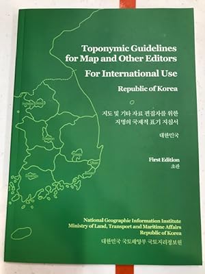
Toponymic guidelines for map and other editors for international use. Republic of Korea
Published by Suwon : National Geographic Information Institute, Ministry of Land, Transport and Maritime Affairs, 2012
ISBN 10: 899384111X ISBN 13: 9788993841114
Seller: Regent College Bookstore, Vancouver, BC, Canada
Seller rating 5 out of 5 stars
First Edition
Soft cover. Condition: As New. 1st Edition. 51 pp. Green cover in excellent condition, no blemishes. Binding is tight. Text block and figures are clear and unmarked. Associated map in pouch in rear.
-

National Geographic Map Of China Coast And Korea Oct 1953
Published by National Geographic, United States, 1953
Map First Edition
soft. Condition: See Pic.
-

National Geographic Map Of China Coast And Korea Oct 1953
Published by National Geographic, United States, 1953
Map First Edition
soft. Condition: See Pic.
-

National Geographic Map Of Japan And Korea Dec 1960
Published by National Geographic, United States, 1960
Map First Edition
soft. Condition: See Pic.
-

National Geographic Map Of China Coast And Korea Oct 1953
Published by National Geographic, United States, 1953
Map First Edition
soft. Condition: See Pic.
-

National Geographic Map Of China Coast And Korea Oct 1953
Published by National Geographic, United States, 1953
Map First Edition
soft. Condition: See Pic.
-

National Geographic Map Of China Coast And Korea Oct 1953
Published by National Geographic, United States, 1953
Map First Edition
soft. Condition: See Pic.
-

National Geographic Map Of Japan And Korea Dec 1960
Published by National Geographic, United States, 1960
Map First Edition
soft. Condition: See Pic.
-

National Geographic Map Of China Coast And Korea Oct 1953
Published by National Geographic, United States, 1953
Map First Edition
soft. Condition: See Pic.
-

National Geographic Map Of The China Coast And Korea Oct 1953
Published by National Geographic, United States, 1953
Map First Edition
soft. Condition: See Pic.
-

National Geographic Map Of Japan And Korea December 1960
Published by National Geographic, United States, 1960
Map First Edition
soft. Condition: See Pic.
-

National Geographic Map Of China Coast And Korea Oct 1953
Published by National Geographic, United States, 1953
Map First Edition
soft. Condition: See Pic.
-
National Geographic Magazine - July, 2003, With Folding Separate Supplement Map, "The Two Koreas". Divided Korea; Animal Mating Game; China's Bronze Age; Where Have the Salmon Gone ?; 3-Peaks Challenge; Peru, Indiana
Language: English
Published by National Geographic Society, Washington, DC, 2003
Seller: Singularity Rare & Fine, Baldwinsville, NY, U.S.A.
Seller rating 5 out of 5 stars
First Edition
Soft cover. Condition: Near Fine. 1st Edition. Near Fine. See scan and description. Washington, DC: National Geographic Society, 2003. The July, 2003 issue of the iconic National Geographic magazine, Volume 204, Number 1. Includes the supplemental "The Two Koreas" folding separate supplement map. Quarto, photo-iillustrated perfect-bound wraps, 134 pp. Near Fine; spot at left edge of cover (see scan), faint crease at rear cover upper left corner (hard to see; zoom on rear cover scan). Otherwise, flawless. Bright and tight. Laid-in subscriber offer is still within, untouched. Feature topics in this issue of the always content-rich NGS magazine include Divided Korea; Animal Mating Game; China's Bronze Age; Where Have the Salmon Gone ?; 3-Peaks Challenge; Peru, Indiana (ZipUSA). Departments: OnScreen & Online, From the Editor, Forum, Geographica, Behind the Scenes, Who Knew?, Final Edit, On Assignment, and Flashback. See scans. Shipped in a new, protective box; no bag for this one. LPR17.
-

PRINT: "Crisis in the Far East--Scenes in Japan, Korea, and Manchuria".double page (map, photos) from Harper's Weekly, January 16, 1904
Published by Harper's Weekly, NY, 1904
Seller: Dorley House Books, Inc., Hagerstown, MD, U.S.A.
Seller rating 4 out of 5 stars

Art / Print / Poster First Edition
Unbound. Condition: Very Good. b/w Photos, Maps (illustrator). 1st. double page w/map of area surrounded by 8 b/w sterographs of scenes relating to the criis (Russo-Japanee war. Very nice, and suitable for framing [imae cuts off margins all around] Size: 18" x 13".
-
The Sunday Magazine of the Philadelphia Press: Pope Pius X - The Pope and the Vatican - Passion Week in Sistine Chapel - Singing For A Sweetheart - Catholic Church - Map of Japanese Empire and Korea
Published by Associated Sunday Magazines, 1904
Magazine / Periodical First Edition
Soft cover. Condition: Very Good. 1st Edition. Original March 27,1904 edition of The Sunday Magazine of the Philadelphia Press. Cover illustration of Pope Pius X.Back cover illustration MAP OF THE JAPANESE EMPIRE AND KOREA. In this issue THE POPE AND THE VATICAN, PASSION WEEK IN SISTINE CHAPEL, JUVENILES AS ARTISTS MODELS, SINGING FOR A SWEETHEART -Also beautiful double-page color illustration titled "THE REPRIMAND".Small thread notchs/scuffing along spine otherwise in very good condition.Should be opened with care. Bookseller since 1995 (LL-17-middle-flat) rareviewbooks Language: eng.
-
Antique Map Japan and Corea [Korea]
Language: English
Published by Montgomery Martin, London, 1851
Map First Edition
US$ 138.57
US$ 47.09 shipping
Ships from United Kingdom to U.S.A.Quantity: 1 available
Add to basketNo Binding. Condition: Very Good. Engraved by Rapkin (illustrator). 1st Edition. Tallis, John: Japan and Corea [Korea], London. [ca.1851]. From the Montgomery Martin Illustrated Atlas. Map engraved by Rapkin. Size approx 360 x 260mm. Original steel engraved map with original outline hand colouring. 3 vignette views showing Coreans [Koreans], State Barge, and Yedo. Decorative border. Single page unfolded map in excellent, clean condition. Associated text page of the Montgomery Martin Atlas included. A Good Tallis Map.
-
CHINA AND THE PRESENT CRISIS. With Notes on a Visit to Japan and Korea. With a Map of China.
Published by Sampson Low, Marston & Company, London, 1900
Seller: Bjarne Tokerud Bookseller, Vancouver, BC, Canada
Association Member: PBFA
Seller rating 5 out of 5 stars
First Edition
Hardcover. Condition: Fine. 1st Edition. London: Sampson Low, Marston & Company, 1900. First Edition. 8vo. 319pp. Folding colour map. Black cloth, gilt spine and gilt stamped cover. Fine. From preface "The eyes of the whole civilized world are now turned towards China, where it appears only too certain that one of the most terrible tragedies which history has ever recorded has just taken place. I spent some eight months recently in travel through China, Japan and Korea, with the special object of ascertaining from the best informed men on the spot what the political and commercial situation really was.".
-
Korea. With Map and Illustrations.
Published by Charles Scribner's Sons, New York, 1904
Seller: CARDINAL BOOKS ~~ ABAC/ILAB, London -- Birr, ON, Canada
Seller rating 5 out of 5 stars
First Edition
Hardcover. Condition: Very Good. 1st Edition. Original dark red cloth hard covers, with printed design to front and titles, now lost, to spine. Some moderate handling to covers; edges toned and some foxing to text. Old owner's name to front free endpaper. Otherwise clean, tight and unmarked. Very neat -- a sound copy. Photographic illustrations -- all present as listed. Folding map at rear. xliv,313pp.
-
1844 BEAUTIFUL Huge Color MAP of CHINA Taiwan Siam Korea Vietnam Burma ATLAS
Published by London : Published by the Society, and Chapman and Hall, 1844., 1844
Map First Edition
No Binding. Condition: Near Fine. 1st Edition. 1844 BEAUTIFUL Huge Color MAP of CHINA Taiwan Siam Korea Vietnam Burma ATLAS From "Society for Diffusion of Useful Knowledge" A beautifully hand-colored map from the 1844 printing of "Society for the Diffusion of Useful Knowledge" The Society for the Diffusion of Useful Knowledge (SDUK), founded in 1826, and wound up in 1848, was a Whiggish London organisation that published inexpensive texts intended to adapt scientific and similarly high-minded material for the rapidly expanding reading public. It was established mainly at the instigation of Lord Brougham with the objects of publishing information to people who were unable to obtain formal teaching, or who preferred self-education. Engraver: J & C Walker Atlas title: Maps of the Society for the Diffusion of Useful Knowledge. Map title: China and Birman Empire, Parts of Cochin China and Siam Published: London : Published by the Society, and Chapman and Hall, 1844. Language: English Notes & contents: Originally from the David Rumsey Collection FREE SHIPPING WORLDWIDE Wear: wear as seen in photos Publisher: London : Published by the Society, and Chapman and Hall, 1844. Size: ~13.5in X 16in (33cm x 41cm).
-
Travelers' Map of Japan, Chosen (Korea), Taiwan (Formosa)
Published by Japanese Government Railways Toyko 1933, 1933
Seller: Andrew Barnes Books / Military Melbourne, Melbourne, VIC, Australia
Seller rating 4 out of 5 stars
First Edition
1st edition Folded Map Nice copy , 80 X 80 cms.
-
![Seller image for China [ Map of China including Korea and Tiawan and showing the routes of Lords Macartney and Amherst ] from The London Atlas of Universal Geography for sale by Keoghs Books](https://pictures.abebooks.com/inventory/md/md30987025439.jpg)
China [ Map of China including Korea and Tiawan and showing the routes of Lords Macartney and Amherst ] from The London Atlas of Universal Geography
Published by Published by J. Arrowsmith Feb. 1840, London, 1840
Seller: Keoghs Books, Skipton, United Kingdom
Association Member: PBFA
Seller rating 5 out of 5 stars
Map First Edition
US$ 346.43
US$ 37.67 shipping
Ships from United Kingdom to U.S.A.Quantity: 1 available
Add to basket, 50.5 x 62.5 cms colour map with central fold, approximately 90 miles to the inch, disbound from an early edition of The London Atlas of Universal Geography First Edition thus , map has one small very neatly repaired edge tear at each margin, otherwise near fine condition 50.5 x 62.5 cms Map ISBN:
-

BEACON'S LARGE-PRINT War Map of China and Japan, MAP OF CHINA, JAPAN and KOREA, Folding MAP
Publication Date: 1900
Seller: Tmecca Inc., Seoul, Korea, Republic of
Association Member: ILAB
Seller rating 2 out of 5 stars

Map First Edition
US$ 300.00
US$ 19.99 shipping
Ships from Korea, Republic of to U.S.A.Quantity: 1 available
Add to basketNo Binding. Condition: As New. 1st Edition. 75 x 54.5 cm.
-
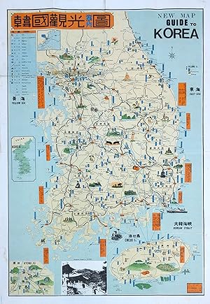
Original Vintage Pictorial Map - New Map Guide to Korea
Publication Date: 1967
Seller: Picture This Gallery (ABA, ILAB, PBFA), Sunningdale, United Kingdom
Association Member: ABA ILAB PBFA
Seller rating 5 out of 5 stars
Map First Edition
US$ 173.21
US$ 33.63 shipping
Ships from United Kingdom to U.S.A.Quantity: 1 available
Add to basketNo Binding. Condition: Near Fine. 1st Edition. Original Vintage Pictorial Map, Offset printing, 53cm x 77cm. Condition Grade: A-, Near Fine. With original folds. The reverse side features a guide map of Seoul.


![Seller image for Antique Map Japan and Corea [Korea] for sale by Roz Hulse](https://pictures.abebooks.com/inventory/md/md19283295553.jpg)