Order Total (1 Item Items):
Shipping Destination:

Land Grant Document (11 results)
Skip to main search results
Search filters
Product Type
- All Product Types
- Books (10)
- Magazines & Periodicals (No further results match this refinement)
- Comics (No further results match this refinement)
- Sheet Music (No further results match this refinement)
- Art, Prints & Posters (No further results match this refinement)
- Photographs (No further results match this refinement)
- Maps (No further results match this refinement)
- Manuscripts & Paper Collectibles (1)
Condition Learn more
- New (No further results match this refinement)
- As New, Fine or Near Fine (1)
- Very Good or Good (4)
- Fair or Poor (1)
- As Described (5)
Binding
- All Bindings
- Hardcover (No further results match this refinement)
- Softcover (No further results match this refinement)
Collectible Attributes
- First Edition (1)
- Signed (5)
- Dust Jacket (No further results match this refinement)
- Seller-Supplied Images (9)
- Not Print on Demand (11)
Language (2)
Price
- Any Price
- Under US$ 25 (No further results match this refinement)
- US$ 25 to US$ 50
- Over US$ 50
Free Shipping
- Free Shipping to U.S.A. (No further results match this refinement)
Seller Location
Seller Rating
-

U.S. Land Grant (Manuscript Document) - Washington, 1893
Publication Date: 1893
Seller: Barry Cassidy Rare Books, Sacramento, CA, U.S.A.
Seller rating 5 out of 5 stars

Signed
No Binding. Condition: Collectible-Very Good. Beige manuscript document signed by the recorder of the General Land Office. Not signed by President Benjamin Harrison. A grant of the "East half of the South West quarter of Section Ten, in Township sixteen North of Range five West of Willamette Meridian, in Washington, containing eighty acres" is made to Hiram F. Martin. 16" x 10." Notation on back of the certificate shows the document has been filed and recorded with the county in 1893. Red seal in corner of document. Document, handwriting, and signatures are very clean and intact. Signed by Author(s).
-
Memorial of the Legislature of Wisconsin, Praying a Grant of Land to Aid in the Improvement of the Wisconsin River between Fort Winnebago and the Beaulieux Rapids. April 26, 1852. (32nd Cong., 1st Sess., Senate Miscellaneous Document, #73)
Published by Washington:, 1852
Seller: Zubal-Books, Since 1961, Cleveland, OH, U.S.A.
Seller rating 5 out of 5 stars
Condition: Good. *Price HAS BEEN REDUCED by 10% until Monday, June 15 (weekend SALE item)* 9 pp., Paperback, 2 pp., 7 maps, extracted from larger bound volume, good. - If you are reading this, this item is actually (physically) in our stock and ready for shipment once ordered. We are not bookjackers. Buyer is responsible for any additional duties, taxes, or fees required by recipient's country.
-

Document signed, in a secretarial hand, Land Grant of 160 acres to John H. Trevarrow, in Township sixteen South of Range thirteen West of New Mexico Meridian
Published by Las Cruces, New Mexico, 1904
Seller: James Cummins Bookseller, ABAA, New York, NY, U.S.A.
Seller rating 5 out of 5 stars
Partly printed Homestead certificate 1686, accomplished in ink, with orange seal of General Land Office affixed lower left. 1 pp. Oblong folio. Homestead Certificate for a farm in New Mexico, issued early in Thodore Roosevelt's second term. Old folds, minor soiling. Docketed on verso, ?this farm sold to Eleanor Allison, ALM? with date 15 January 1925. Fine. Tan cloth folding case Partly printed Homestead certificate 1686, accomplished in ink, with orange seal of General Land Office affixed lower left. 1 pp. Oblong folio.
-
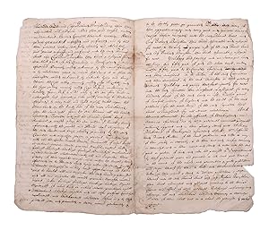
Manuscript document, early true copy of the grant by the Council of New England to Thomas Lewis and Richard Bonighton of the land on the north side of the Saco River
Published by [Likely Boston], 1680
Seller: James Cummins Bookseller, ABAA, New York, NY, U.S.A.
Seller rating 5 out of 5 stars
Signed
4pp. Clerically signed Robert Warwick and Edward Gorges above an additional reaffirmation of grant dated June 1631, clerically countersigned by Thomas Wiggin, James Parker, James Watts, and George Donglan. Docketed "Patent Saco: east of the river". Bifolium. In 1629, less than a decade after the Pilgrims landed at Plymouth Rock, the Council of New England, an English joint stock company founded to establish colonial settlements in America, issued a series of grants subdividing their royal charter that had ceded to them all land between "degrees 34 and 44," from sea to sea. These grants were important, being among the earliest grants independently issued within the colonies. The present grant is of particular note for the history of Maine, being the grant made to Thomas Lewis and Captain Richard Bonython for the land north of the Swanckadocke River, i.e. the Saco River. The text of the grant reads (in part): ".Whereas King James of famous memory, late King of England, Scotland, France, and Ireland, by his Highness' letters patent and royal grant under the great seal of England, bearing date the third day of November in the eighteenth year of his reign of England, France, and Ireland, etc., for the causes therein expressed did absolutely give, grant, and confirm to the said Council for the affairs of New England in America, and their successors forever, all the land of New England lying and being from forty to forty-eight degrees of northerly latitude and in length by all that breadth aforesaid from sea to sea throughout the main land . that the said council for the affairs of New England in America, as well for and in consideration that Thomas Lewis, Gentleman, has already been at the charge to transport himself and others to take a view of New England in America aforesaid for the bettering of his experience in advancing of a plantation, and does now wholly intend by God's assistance with his associates to plant there, both for the good of his Majesty's realms and dominions and for the propagation of Christian religion among those infidels, and in consideration also that the said Thomas Lewis together with Captain Richard Bonighton, and also with their associates and company, have undertaken at their own proper costs and charges to transport fifty persons there within seven years next ensuing to plant and inhabit there to the advancement of the general plantation of that country and the strength and safety thereof among the natives or any other invaders, also for the encouragement of the said Thomas Lewis and Captain Richard Bonighton, and other considerations the said council thereunto moving, have given, granted, enfeoffed, and confirmed, and by this present writing do fully, clearly, and absolutely give, grant, enfeof, and confirm to the said Thomas Lewis and Captain Richard Bonighton, their heirs and assigns for ever, all that part of the main land in New England in America, aforesaid, commonly called or known by the name of Swanckadocke, or by whatsoever other name or names the same is or shall be hereafter called or known by, situated, lying, and being between the cape or bay commonly called Cape Elizabeth and the cape or bay commonly called Cape Porpoise, containing in breadth from northeast to southwest along by the sea four miles in a straight line, or accounting seventeen hundred and three score yards according to the standard of England to every mile, and eight English miles upon the main land on the north side of the river Swanckadock after the same rate, from the sea through all the breadth aforesaid ." The original vellum grant with seals is located in the archives of the Maine Historical Society. The present example is one of several extant early manuscript copies made during the subsequent conflicts and competing claims between the crown, Massachusetts and Maine. In 1652, commissioners were appointed to determine the correct boundary between Massachusetts and several of the early patents, with the former gradually extending their claim northward. In 1653 the settlers of Saco and other parts of Maine yielded to Massachusetts and the region was renamed Yorkshire, or County of York. In 1664, after the Restoration, the region was restored as an independent province, but much of the region sold back to Massachusetts in 1678. After the charter of Massachusetts was annulled in 1684 and James II ascended to the crown in 1685, the region was once again assigned as part of the Province of Massachusetts Bay. Maine would remain part of Massachusetts until the final separation in 1820. The present undated copy likely dates from the period circa 1664 when a royal commission consisting of Richard Nicolls, Sir Robert Carre, George Cartwright and Samuel Maverick was sent to oversee the government of the colonies in New England. However, it could also date as late as the period from the 1680s when Sir Edmund Andros became the Commissioner for the Dominion of New England. Documentary History of the State of Maine, vol. 7, p. 117 Usual folds, minor separations, two repaired 4pp. Clerically signed Robert Warwick and Edward Gorges above an additional reaffirmation of grant dated June 1631, clerically countersigned by Thomas Wiggin, James Parker, James Watts, and George Donglan. Docketed "Patent Saco: east of the river". Bifolium. Signed.
-
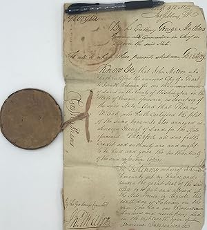
Survey warrant and land grant for acreage on the Ohoopee River, Georgia Printed document, completed in manuscript, signed
Published by 1793-1794, Washington County, Georgia, 1793
Seller: Rodger Friedman Rare Book Studio, ABAA, Tuxedo, NY, U.S.A.
Seller rating 5 out of 5 stars
Signed
Condition: Acceptable. 2 leaves with pendant wax seal. Georgia Land Office grant, 33 cm x 33cm, signed by Governor George Mathews, countersigned by Edward Watts and docketed by Secretary of State John Milton. Attached surveying document 17cm x ~28cm, with manuscript plan of property and surveyor's warrant, signed by surveyor George Wetherby, and endorsed by T. McCall, naing chain carriers H. Holley and J. Coleman 1000 acres granted to Richmond Dawson by the governor who would in the succeeding years mastermind the Yazoo Land Fraud, selling large tracts of land at bargain basement prices to political insiders. The grant for 1000 acres in Washington County is to Richmond Dawson.
-
![Seller image for July 1, 1831 Land Grant Document to John Webster [Signed] for sale by William Chrisant & Sons, ABAA, ILAB. IOBA, ABA, Ephemera Society](https://pictures.abebooks.com/inventory/md/md30762038939.jpg)
July 1, 1831 Land Grant Document to John Webster [Signed]
Published by United States Government Printing Office July 1, 1831, Washington, D.C., 1831
Seller: William Chrisant & Sons, ABAA, ILAB. IOBA, ABA, Ephemera Society, Fort Lauderdale, FL, U.S.A.
Association Member: ABAA ESA ILAB
Seller rating 5 out of 5 stars
First Edition Signed
Condition: Very Good. First Edition. Partly printed, partly manuscript vellum Land Grant boldly signed by the president for John Webster of Wayne County, Ohio, which was "deposited in the General Land Office of the United States, a certificate of the Register of the Land Office at Wooster." Also stated: ".according to the provisions of the Act of Congress of the 24th of April 1820 entitled 'An act making further provision for the sale of the Public Lands' for the West half of the North East quarter of section thirty five of township twenty two in Range fifteen in the district of lands subject to the sale at Wooster Ohio containing Eighty acres." Also signed by Elijah Hayward, Commissioner of the General Land Office. 5 total fold lines (see image). United States Land Office seal. Vellum: 15 1/4 x 9 3/4 inches.
-
![Seller image for Document Signed ("James Monroe") as President, being a land grant for Jeremiah Cox of Wayne County [Indiana] for sale by James Cummins Bookseller, ABAA](https://pictures.abebooks.com/inventory/md/md22486019974.jpg)
Document Signed ("James Monroe") as President, being a land grant for Jeremiah Cox of Wayne County [Indiana]
Published by Washington, D.C., 1824
Seller: James Cummins Bookseller, ABAA, New York, NY, U.S.A.
Seller rating 5 out of 5 stars
1 page, engraved and completed in manuscript; red wafer seal (chipped), docketed on verso. Oblong folio. The grant is for "Section Nineteen, in Township Twenty of Range Fifteen east of the second principal Meridian in the Distict of Cincinnati and State of Indiana, containing Six Hundred and forty Acres." Jeremiah Cox (1763-1836) was among the earliest settlers of Wayne County, Indiana. On vellum. Light staining, folding creaes 1 page, engraved and completed in manuscript; red wafer seal (chipped), docketed on verso. Oblong folio.
-
Land Grant document
Language: English
Publication Date: 1867
Seller: Anah Dunsheath RareBooks ABA ANZAAB ILAB, Auckland, NZ, New Zealand
Association Member: ABA ANZAAB ILAB
Seller rating 5 out of 5 stars
Manuscript / Paper Collectible
US$ 2,059.66
US$ 25.00 shipping
Ships from New Zealand to U.S.A.Quantity: 1 available
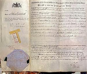
Add to basketNo Binding. Condition: Very Good. Vellum page 26 x 31 cm folding into 26 x 11 cm, with crown seal and signed by Governor George Grey. Comprises a legal document providing a grant to one John Goodall, Corporal in the Third Regiment of Waikato Militia for a 1 acre parcel of land in the town of Cambridge, Parish of Hautapu, Waikato.
-

Land Grant Document Secretarially Signed for President Martin Van Buren
Seller: Between the Covers-Rare Books, Inc. ABAA, Gloucester City, NJ, U.S.A.
Association Member: ABAA ESA ILAB IOBA
Seller rating 5 out of 5 stars
Unbound. Condition: Near Fine. Vellum document. Approximately 16" x 10". Affixed paper seal. Old folds, a little toning, small crease in lower right corner, else near fine. Signed twice in a secretarial hand for President Martin Van Buren. A land grant for property in Vandalia, Illinois issued to several people named Smith, and dated in August, 1838.
-
![Seller image for Province of South Australia. Land Grant under Preliminary Sales in England and Partial Purchase in the Province. Country Section. [A printed document, with manuscript insertions] for sale by Michael Treloar Booksellers ANZAAB/ILAB](https://pictures.abebooks.com/inventory/md/md30741227933.jpg)
Province of South Australia. Land Grant under Preliminary Sales in England and Partial Purchase in the Province. Country Section. [A printed document, with manuscript insertions]
Seller: Michael Treloar Booksellers ANZAAB/ILAB, Adelaide, SA, Australia
Association Member: ANZAAB ILAB
Seller rating 5 out of 5 stars
Folio (approximately 353 � 232 mm), a single leaf (trimmed from a standard form, a bifolium with the centrefold blank, and the last page merely docketed), now mounted on plain paper (360 � 228 mm), with a small hand-coloured diagram of the block (showing the orientation of the land), and a paper-over-wax impressed seal, signed by George Gawler as Resident Commissioner, 19 January 1841. Other signatories are the Private Secretary, George Hall; the Treasurer, John Alexander Jackson; and Alfred Reynell (brother of John, patriarch of the eponymous wine family). The document has a few horizontal creases where originally folded; the mounted document has been rolled up at some stage, and is a little curled; a short sealed tear to the right edge; a few minor blemishes near the top edge and the bottom portion of the seal, and some light overall fading (these are possibly a legacy from having been framed at some stage), overall, a very presentable example of a very rare colonial document. Land Grant Number 639 is for 'Eighty-two acres numbered "903" in the Provincial Survey', purchased by 'James Warland and George Warland of Adelaide' for the sum of �2. Elizabeth Warburton, in 'The Paddocks Beneath. A History of Burnside from the Beginning' (1981), makes short work of locating the land in question in this leafy suburb about eight kilometres from the Adelaide GPO, and paying the brothers Warland their due. 'There can hardly be a family with deeper roots in Burnside than the Warlands, who settled there in 1838. James Warland (1796-1875), with his brothers from Wimborne in Dorset, took assisted passages to South Australia in 1837. Their first leaseholding was on Section 904, Clifton; then in 1840, having paid two pounds down, they were in nominal possession of Section 903 on the other side of Greenhill Road, bounded on the west by today's Wyatt Road. After his retirement Henry Warland built here, on land inherited from his father [George], a pleasant stone farmhouse named "Wimborne", which his grandson Eric Warland maintains at 6 Wyatt Road' (page 24). George Gawler (1795-1869) was South Australia's second governor. 'Disputes between the first governor, Captain (Sir) John Hindmarsh, and the resident commissioner, (Sir) James Fisher, over their respective jurisdictions had retarded the colony's development, so the two offices were combined in Gawler. Thus, as governor he became representative of the Colonial Office in the province, and as resident commissioner, representative of the non-governmental Colonization Commission which was responsible for the control of land sales, for applying the proceeds to the emigration of labourers and for raising loans until such time as the colony had sufficient revenue to support itself. On 12 October 1838 Gawler with his wife and five children arrived in Adelaide in the "Pestonjee Bomanjee" and found conditions far worse than he had been led to expect. The most urgent necessity, he believed, was to promote rural settlement. He persuaded Charles Sturt to accept the post of surveyor-general and, until he could assume office, Gawler himself took charge of the Survey Department, reorganizing it and conducting preliminary explorations. He also hired every available surveyor, including some of Light's former officers. In October 1839, to his dismay, he was ordered to dismiss them. The commissioners had appointed Lieutenant Edward Frome as surveyor-general and sent him out with a party of sappers. Gawler solved the problem by amalgamating the two forces, feeling justified by the increasing volume of land sales. In 1839 over 170,000 acres (68,797 ha) were sold'. Gawler produced results: within twelve months 200,000 acres had been surveyed, and by May 1841 mapping of 7000 square miles had been completed, and over 500,000 acres divided into sections. This rare land grant is evidence of Gawler's energy and zeal. Unhappily for him, history was about to repeat itself: his 'major weakness was his complete failure to understand political realities. His recall and his successor, Captain (Sir) George Grey, arrived together on 10 May 1841' ('Australian Dictionary of Biography').
-
Endorsing the grant of a tract of land to Israel Robinson, 1000 acres in Washington County, Georgia, in a clerical folio manuscript document, signed by Mathews as governor February 10, 1794;
Seller: Bartleby's Books, ABAA, Chevy Chase, MD, U.S.A.
Association Member: ABAA ESA ILAB IOBA
Seller rating 5 out of 5 stars
Signed
to which is attached a two-page folio manuscript document dated September 11, 1793, being a certified copy of the original grant made May 11, 1793, signed by then Governor Edward Telfair, his signature in the hand of W. Urquhart, "S.E.D.", signed also by John Milton, Georgia's Secretary of State; to this is attached a plat description (one-page folio, dated September 12, 1793) signed by Thomas McCall, Surveyor General of Georgia, and John Milton as Secretary of State. Augusta, GA, 1794. A wonderful survival evoking the era of the Yazoo Land Frauds. Both Governor George Mathews and his immediate predecessor Edward Telfair were or were about to be tainted with involvement in Georgia land speculation; Mathews, as governor, in fact signed the notorious Yazoo Land Act. Having served in the Revolution, Mathews had been nominated as the first governor of the Mississippi Territory, but lost the appointment because of dubious land speculation and alleged involvement on the Blount Conspiracy; later he played a leading role in fomenting revolution in Florida. Telfair, a prominent rebel during the revolution and a member of the Continental Congress, served as governor 1789-1793, during which time "he was reckless in his dealings with the state's lands" (DAB). Some wear and fraying at the edges, a few small splits at folds, still a very good example, all soundly secured by the original pink ribbon from which the great seal of Georgia is suspended. Folded. (#7655).