Order Total (1 Item Items):
Shipping Destination:

Lorraine: Maps (156 results)
Skip to main search results
Search filters
Product Type
- All Product Types
- Books (No further results match this refinement)
- Magazines & Periodicals (No further results match this refinement)
- Comics (No further results match this refinement)
- Sheet Music (No further results match this refinement)
- Art, Prints & Posters (No further results match this refinement)
- Photographs (No further results match this refinement)
- Maps (156)
- Manuscripts & Paper Collectibles (No further results match this refinement)
Condition Learn more
- New (5)
- As New, Fine or Near Fine (35)
- Very Good or Good (34)
- Fair or Poor (No further results match this refinement)
- As Described (82)
Binding
Collectible Attributes
Language (7)
Free Shipping
- Free Shipping to U.S.A. (No further results match this refinement)
Seller Location
Seller Rating
-

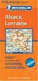
Michelin Regional France Alsace, Lorraine Map
Language: English
Published by Michelin Travel Pubns, 2023
ISBN 10: 2067258680 ISBN 13: 9782067258686
Map
Other cartographic. Condition: Brand New. fol map bl edition. 1 pages. French language. 10.00x4.50x0.20 inches. In Stock.
-

MAP: "The Batlefield of Verdun & Lorraine" ( Plate #VI, American Geographical Research Society Series 3
Language: English
Published by Oxford University Press, NY, 1921
Seller: Dorley House Books, Inc., Hagerstown, MD, U.S.A.
Seller rating 4 out of 5 stars

Map First Edition
No Binding. Condition: Very Good. b/w battlefield map (illustrator). 1st Edition. 14" x 18" b & w battlefield map of the Battles of Flanders, World War I; scale, 1 1/2" = 5 miles; [ World War I map, from 1921 book, Battlefields of the World War: Western and Southern Douglas Wilson Johnson, published as part of the American Geographical Society's Research Series no. 3, notes. .a block diagram of the asymettrical plateaus and lowlands of Northeastern France w/terraines for the Verdun & Lorran battlefields.
-

Carte touristique IGN au 1:250 000 N� 1 : Lorraine-Alsace.
Published by Institut G�ographique National, 1976
Seller: LIVRES ANCIENS ET CONTEMPORAINS, HASPARREN, France
Seller rating 5 out of 5 stars

Map
Couverture souple. Condition: Assez bon. PM-GLN-711.
-

CARTE - MAP - KARTE LORRAINE
Published by Turisme en Lorraine, 2002
Seller: Historia, Regnum et Nobilia, BATTIPAGLIA, SA, Italy
Seller rating 4 out of 5 stars
Map First Edition
senza rilegatura. Condition: ottimo. prima edizione. Mappa ripiegata a colori in edizione plurilingue.
-
The German Empire, (West sheet), Rhenish Prussia, Schleswig - Holstein, Mecklenburg, Alsace-Lorraine, Baden, W�rttemberg, Bavaria, &c.
Publication Date: 1893
Map
US$ 12.51
US$ 13.50 shipping
Ships from United Kingdom to U.S.A.Quantity: 2 available
Add to basketCondition: Good. GERMAN EMPIRE WEST. Rhenish Prussia Schleswig Alsace Bavaria. BLACKIE 1893 map. Colour Antique map; Blackie & Son (1893). 52.0 x 35.0cm, 20.5 x 13.75 inches; this is a folding map. Condition: Good. There is nothing printed on the reverse side, which is plain.
-
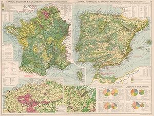
France, Belgium & Luxemburg - Commercial Development; Spain, Portugal & Spanish Morocco - Commercial Development; Inset maps of Northern France & Belgium industrial regions; Lorraine & Saar Basin
Publication Date: 1925
Map
US$ 13.21
US$ 13.50 shipping
Ships from United Kingdom to U.S.A.Quantity: 2 available
Add to basketCondition: Good. France Belgium Spain Portugal. Commercial Development. Manufacturing 1925 map. Vintage colour atlas map. Scale 1: 1,500,000; 1: 4,500,000; George Philip & Son (1925). 37.5 x 49.5cm, 14.75 x 19.5 inches; this is a folding map. Condition: Good. There is related text printed on the reverse side. The paper is thick, and the verso text does not show through to the front.
-

"Plan de la Ville de Lonwi" - Longwy Meurthe-et-Moselle Lorraine Lothringen gravure carte map
Language: French
Published by Paris, 1680
Seller: Antiquariat Steffen V�lkel GmbH, Seubersdorf, Germany
Seller rating 5 out of 5 stars
Map
Seltener OriginalKupferstich aus dem kleinen Beaulieu-Atlas von ca. 1680. -- Blatt-Format: ca.17 x21,5 cm. -- gut erhalten. || Rare original copper-engraving from the Beaulieu-Atlas from circa 1680. in good condition. || Rare gravure sur cuivre originale de l'Atlas de Beaulieu vers 1680.|| Dies ist ein Original! - Kein Nachdruck! - Keine Kopie! -- This is an original! - No copy! - No reprint! // Wir, das Antiquariat Steffen V�lkel, kaufen und verkaufen alte B�cher, Handschriften, Zeichnungen, Autographen, Grafiken und Fotografien. Wir sind stets am Ankauf von kompletten Bibliotheken, Sammlungen und Nachl�ssen interessiert. Sprache: Franz�sisch Gewicht in Gramm: 10.
-
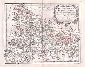
"Flandre Francoise, Picardie et Artois, Isle de France, Orleanois, Champagne, Lorraine, et Alsace." - Picardie Artois Champagne Alsace Lorraine Isle de France carte Karte map
Language: French
Published by Paris, 1780
Seller: Antiquariat Steffen V�lkel GmbH, Seubersdorf, Germany
Seller rating 5 out of 5 stars
Map
Blattmasse: ca. 29 x 44,5 cm. - Grenzkolorierte Kupferstich-Karte von ca. 1780. -- gut erhalten. || Colored copper engraved map from circa 1780. in very good condition. | // Wir, das Antiquariat Steffen V�lkel, kaufen und verkaufen alte B�cher, Handschriften, Zeichnungen, Autographen, Grafiken und Fotografien. Wir sind stets am Ankauf von kompletten Bibliotheken, Sammlungen und Nachl�ssen interessiert. Sprache: Franz�sisch Gewicht in Gramm: 1550.
-

"Carte du Gouvernement de Bar le Duc" - Bar-le-Duc Ligny-en-Barrais Revigny Meuse Lorraine Lothringen carte gravure estampe
Language: French
Published by Paris, 1680
Seller: Antiquariat Steffen V�lkel GmbH, Seubersdorf, Germany
Seller rating 5 out of 5 stars
Map
Seltener OriginalKupferstich aus dem kleinen Beaulieu-Atlas von ca. 1680. -- Blatt-Format: ca.17 x21,5 cm. -- gut erhalten. || Rare original copper-engraving from the Beaulieu-Atlas from circa 1680. in good condition. || Rare gravure sur cuivre originale de l'Atlas de Beaulieu vers 1680.|| Dies ist ein Original! - Kein Nachdruck! - Keine Kopie! -- This is an original! - No copy! - No reprint! // Wir, das Antiquariat Steffen V�lkel, kaufen und verkaufen alte B�cher, Handschriften, Zeichnungen, Autographen, Grafiken und Fotografien. Wir sind stets am Ankauf von kompletten Bibliotheken, Sammlungen und Nachl�ssen interessiert. Sprache: Franz�sisch Gewicht in Gramm: 10.
-

"Plan de la Ville de Toul" - Toul Meurthe-et-Moselle Lorraine Lothringen gravure estampe Plan
Language: French
Published by Paris, 1680
Seller: Antiquariat Steffen V�lkel GmbH, Seubersdorf, Germany
Seller rating 5 out of 5 stars
Map
Seltener OriginalKupferstich aus dem kleinen Beaulieu-Atlas von ca. 1680. -- Blatt-Format: ca.17 x21,5 cm. -- gut erhalten. || Rare original copper-engraving from the Beaulieu-Atlas from circa 1680. in good condition. || Rare gravure sur cuivre originale de l'Atlas de Beaulieu vers 1680.|| Dies ist ein Original! - Kein Nachdruck! - Keine Kopie! -- This is an original! - No copy! - No reprint! // Wir, das Antiquariat Steffen V�lkel, kaufen und verkaufen alte B�cher, Handschriften, Zeichnungen, Autographen, Grafiken und Fotografien. Wir sind stets am Ankauf von kompletten Bibliotheken, Sammlungen und Nachl�ssen interessiert. Sprache: Franz�sisch Gewicht in Gramm: 10.
-

"Plan de la Ville de Verdun" - Verdun Meuse Lorraine Lothringen gravure estampe
Language: French
Published by Paris, 1680
Seller: Antiquariat Steffen V�lkel GmbH, Seubersdorf, Germany
Seller rating 5 out of 5 stars
Map
Seltener OriginalKupferstich aus dem kleinen Beaulieu-Atlas von ca. 1680. -- Blatt-Format: ca.17 x21,5 cm. -- gut erhalten. || Rare original copper-engraving from the Beaulieu-Atlas from circa 1680. in good condition. || Rare gravure sur cuivre originale de l'Atlas de Beaulieu vers 1680.|| Dies ist ein Original! - Kein Nachdruck! - Keine Kopie! -- This is an original! - No copy! - No reprint! // Wir, das Antiquariat Steffen V�lkel, kaufen und verkaufen alte B�cher, Handschriften, Zeichnungen, Autographen, Grafiken und Fotografien. Wir sind stets am Ankauf von kompletten Bibliotheken, Sammlungen und Nachl�ssen interessiert. Sprache: Franz�sisch Gewicht in Gramm: 10.
-

"Plan de la Ville de Luneville" - Luneville Meurthe-et-Moselle Lorraine Lothringen gravure estampe
Language: French
Published by Paris, 1680
Seller: Antiquariat Steffen V�lkel GmbH, Seubersdorf, Germany
Seller rating 5 out of 5 stars
Map
Seltener OriginalKupferstich aus dem kleinen Beaulieu-Atlas von ca. 1680. -- Blatt-Format: ca.17 x21,5 cm. -- gut erhalten. || Rare original copper-engraving from the Beaulieu-Atlas from circa 1680. in good condition. || Rare gravure sur cuivre originale de l'Atlas de Beaulieu vers 1680.|| Dies ist ein Original! - Kein Nachdruck! - Keine Kopie! -- This is an original! - No copy! - No reprint! // Wir, das Antiquariat Steffen V�lkel, kaufen und verkaufen alte B�cher, Handschriften, Zeichnungen, Autographen, Grafiken und Fotografien. Wir sind stets am Ankauf von kompletten Bibliotheken, Sammlungen und Nachl�ssen interessiert. Sprache: Franz�sisch Gewicht in Gramm: 10.
-
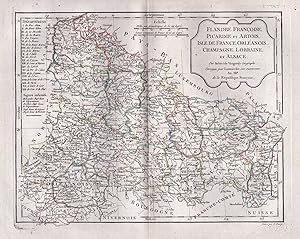
"Flandre Francoise, Picardie et Artois, Isle de France, Orleanois, Champagne, Lorraine, et Alsace." - Picardie Artois Champagne Alsace Lorraine Isle de France carte Karte map
Language: French
Published by Paris, 1780
Seller: Antiquariat Steffen V�lkel GmbH, Seubersdorf, Germany
Seller rating 5 out of 5 stars
Map
Altkolorierte Kupferstich-Karte von Didier Robert de Vaugondy (c.1723-1786) von ca. 1780. -- Blatt-Format: ca. 40 x 29 cm. -- gut erhalten. || Old colored copper engraved map by Didier Robert de Vaugondy (c.1723-1786) from c. 1780. -- in very good condition. || Dies ist ein Original! - Kein Nachdruck! - Keine Kopie! -- This is an original! No copy! - No reprint! // Wir, das Antiquariat Steffen V�lkel, kaufen und verkaufen alte B�cher, Handschriften, Zeichnungen, Autographen, Grafiken und Fotografien. Wir sind stets am Ankauf von kompletten Bibliotheken, Sammlungen und Nachl�ssen interessiert. Sprache: Franz�sisch Gewicht in Gramm: 1550.
-
Michelin France Alsace, Lorraine (Michelin Local France Maps) (Multilingual Edition)
Language: English
Published by Michelin Travel Publications, 2006
ISBN 10: 2067106325 ISBN 13: 9782067106321
Map
map. Condition: Very Good. Great used condition.Over 1,000,000 satisfied customers since 1997! Choose expedited shipping (if available) for much faster delivery. Delivery confirmation on all US orders.
-

The German Empire (West Sheet) Rhenish Prussia, Schleswig-Holstein, Mecklenburg, Alsace- Lorraine, Baden, W�rtemburg, Bavaria &c.
Publication Date: 1886
Map
US$ 20.85
US$ 13.50 shipping
Ships from United Kingdom to U.S.A.Quantity: 2 available
Add to basketCondition: Good. GERMAN EMPIRE WEST. Inc. Alsace-Lorraine. Rhenish Prussia Bavaria &c 1886 map. Antique colour map; Engraved by Edwd. Weller, Red Lion Square; drawn by Edwd. Weller F.R.G.S (1886). 52.5 x 36.0cm, 20.75 x 14 inches; this is a folding map. Condition: Good. There is nothing printed on the reverse side, which is plain.
-
US$ 20.85
US$ 13.50 shipping
Ships from United Kingdom to U.S.A.Quantity: 1 available
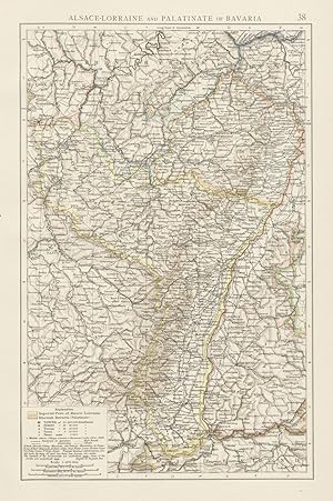
Add to basketCondition: Good. Rhine valley. Alsace-Lorraine & Palatinate of Bavaria. Rhineland. TIMES 1900 map. Antique colour atlas map; The Times (1900). 39.5 x 26.0cm, 15.5 x 10.25 inches. Condition: Good. There is nothing printed on the reverse side, which is plain.
-

ORIGINAL ANTIQUE MAP TAKEN FROM A DISBOUND COPY OF. SPRUNER-MENKEHAND-ATLASPublished 1880Map dated 1875. Condition/Description: a detailed and attractive map in generally good, clean condition, printed on a medium weight paper with centre fold, measuring 40cm x 33cm approx with margins beyond, blank verso, perfectly suitable for framing and/or reference - please refer to images and examine carefully. Thank you. GENUINE ANTIQUE MAP. NOT A COPY. NOT A REPRODUCTION. MONEY BACK GUARANTEE IF NOT COMPLETELY SATISFIED.DISCOUNTS AVAILABLE ON MUTIPLE PURCHASES - PLEASE ASK.
-

ORIGINAL ANTIQUE MAP TAKEN FROM A DISBOUND COPY OF. SPRUNER-MENKEHAND-ATLASPublished 1880Map dated 1873. Condition/Description: a detailed and attractive map in generally good, clean condition, printed on a medium weight paper with centre fold, measuring 40cm x 33cm approx with margins beyond, blank verso, perfectly suitable for framing and/or reference - please refer to images and examine carefully. Thank you. GENUINE ANTIQUE MAP. NOT A COPY. NOT A REPRODUCTION. MONEY BACK GUARANTEE IF NOT COMPLETELY SATISFIED.DISCOUNTS AVAILABLE ON MUTIPLE PURCHASES - PLEASE ASK.
-
US$ 22.24
US$ 13.50 shipping
Ships from United Kingdom to U.S.A.Quantity: 4 available
Add to basketCondition: Good. Rhine valley. Alsace-Lorraine & Palatinate of Bavaria. Rhineland. TIMES 1895 map. Antique colour atlas map; The Times (1895). 39.5 x 26.0cm, 15.5 x 10.25 inches. Condition: Good. There is nothing printed on the reverse side, which is plain.
-

GUIDE DE TOURISME - ALSACE ET LORRAINE - VOSGES
Map
Couverture souple. Condition: bon. RO80196961: D�pot l�gal 1987. In-4. Broch�. Bon �tat, Couv. convenable, Dos satisfaisant, Int�rieur frais. 205 pages augment�es de nombreuses illustrations et cartes en couleurs dans et hors texte -. . . . Classification Dewey : 912-Atlas, cartes et plans.
-

"Le Fort Louis du Rhein" - Fort-Louis Rhein Rhin Lorraine Lothringen gravure
Language: French
Published by Paris, 1693
Seller: Antiquariat Steffen V�lkel GmbH, Seubersdorf, Germany
Seller rating 5 out of 5 stars
Map
Original Kupferstich von Nicolas de Fer. Aus "Les Forces de l'Europe" von 1693. -- Blatt-Ma�e: ca. 26 x 33 cm. -- gut erhalten. || Original copper engraving by Nicolas de Fer. Out of "Les Forces de l'Europe" from 1693. -- in good condition. // Wir, das Antiquariat Steffen V�lkel, kaufen und verkaufen alte B�cher, Handschriften, Zeichnungen, Autographen, Grafiken und Fotografien. Wir sind stets am Ankauf von kompletten Bibliotheken, Sammlungen und Nachl�ssen interessiert. Sprache: Franz�sisch Gewicht in Gramm: 1550.
-

Serie Verte 12: Strasbourg Forbach. Parcs naturels regionaux de lorraine (est) et des vosges du nord. 1:100.000
Published by IGN, Paris, 1996
Seller: Versandantiquariat Rainer Kocherscheidt, Velbert, Germany
Association Member: GIAQ
Seller rating 5 out of 5 stars
Map
Gefalzt. Condition: Gut. gefalzte farbige Landkarte. Landkarte.
-

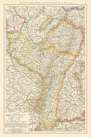
"Carte des Gouvernements de Lorraine et D'Alsace." - Lorraine Alsace Lothringen Elsass Haut Rhin Vosges Haute Marne
Language: French
Published by Paris, 1771
Seller: Antiquariat Steffen V�lkel GmbH, Seubersdorf, Germany
Seller rating 5 out of 5 stars
Map
Original handkolorierte Kupferstich-Karte von 1771. -- Blattmasse: ca. 39 cm x 52 cm, Kartenmasse: ca. 30 cm x 40 cm. -- gut erhalten. || -- Original hand-colored engraved map from 1771. -- in very good condition. // Wir, das Antiquariat Steffen V�lkel, kaufen und verkaufen alte B�cher, Handschriften, Zeichnungen, Autographen, Grafiken und Fotografien. Wir sind stets am Ankauf von kompletten Bibliotheken, Sammlungen und Nachl�ssen interessiert. Sprache: Franz�sisch Gewicht in Gramm: 25.
-

US$ 27.80
US$ 13.50 shipping
Ships from United Kingdom to U.S.A.Quantity: 1 available
Add to basketCondition: Good. World War 2. Western Front Dec 1944-Feb 1945. Rhineland Alsace Colmar 1959 map. Antique colour military map; Edward J. Krasnoborski (1959). 25.0 x 33.0cm, 9.75 x 13 inches. Condition: Good. There is another map printed on the reverse side.
-
Guide du Pneu Michelin - Vosges, Lorraine, Alsace - 16th Edition
Published by Pneu Michelin - Paris, 1962
Seller: Barberry Lane Booksellers, Bar Harbor, ME, U.S.A.
Seller rating 4 out of 5 stars
Map
Soft cover. Condition: Very Good. Stiff green card-stock wrappers with b/w illustration on front and black and white titling. Typical Michelin sized guide of 4.75" x 10.25" is tight, square, relatively sharp-cornered and free of major flaws or markings. Near Fine and quite uncommon, particularly in USA. In French.
-

Alsace Lorraine - Michelin Regional Map 516
Language: English
Published by Michelin Editions Des Voyages Jan 2023, 2023
ISBN 10: 2067258680 ISBN 13: 9782067258686
Map
Karte. Condition: Neu. Neuware - UPDATED ANNUALLYMichelin hard-cover regional maps for France contain practical road and route information. The special Michelin reads-like-a-book format makes it easy to unfold and refold after use, eliminating the need to spread open the whole map. Maps offer valuable information, including locations of gas stations, rest areas and toll roads on main highways and primary roads, as well as numerous points of interest pulled from Michelin Green Guides. Clear, precise cartography with symbols highlighting important travel information allow travelers to quickly find their way.
-

GRANDE CARTE ROUTIERE N� 2. FRONTIERE NORD EST . ARDENNES BLEGES, LUWEMBOURG, LORRAINE. ECHELLE 1/250000.
Published by TARIDE. Non dat�
Map
Couverture souple. Condition: bon. R150174471: Non dat�. In-Plano. Broch�. Etat d'usage, Couv. convenable, Dos satisfaisant, Pliures. Carte en couleurs de 90 cm / 70 cm dans un �tui. Note au stylo sur l'�tui. . . . Classification Dewey : 912-Atlas, cartes et plans.
-

ATLAS AERIEN / FRANCE / TOME V / ALSACE, VOSGES, LORRAINE, ARDENNES, CHAMPAGNE, MORVAN, BOURGOGNE.
Published by GALLIMARD, 1964
Map
Couverture rigide. Condition: bon. R320009274: 1964. In-4. Cartonnage d'�diteurs. Bon �tat, Couv. convenable, Dos satisfaisant, Int�rieur frais. 187 pages illustr�es de nombreuses photos en noir et blznc - Jaquette satisfaisante et illustr�e de quelques photos en couleur et noir et blanc. Avec Jaquette. . . Classification Dewey : 912-Atlas, cartes et plans.
-

CARTE ROUTIERE N�2BIS - LORRAINE ET ALSACE ( NORD)
Published by EDITIONS TARIDE
Map
Couverture souple. Condition: bon. RO70122790: Non dat�. In-Plano. Broch�. Etat d'usage, Couv. l�g�rement pass�e, Dos satisfaisant, Int�rieur acceptable. Carte d�pliante en couleurs en 16 volets en couleurs au 1/250.000e. . . . Classification Dewey : 912-Atlas, cartes et plans.