Order Total (1 Item Items):
Shipping Destination:

Map Explorations Eastern Equatorial Africa (2 results)
Skip to main search results
Search filters
Product Type
- All Product Types
- Books (No further results match this refinement)
- Magazines & Periodicals (No further results match this refinement)
- Comics (No further results match this refinement)
- Sheet Music (No further results match this refinement)
- Art, Prints & Posters (No further results match this refinement)
- Photographs (No further results match this refinement)
- Maps (2)
- Manuscripts & Paper Collectibles (No further results match this refinement)
Condition Learn more
- New (No further results match this refinement)
- As New, Fine or Near Fine (No further results match this refinement)
- Very Good or Good (No further results match this refinement)
- Fair or Poor (No further results match this refinement)
- As Described (2)
Binding
- All Bindings
- Hardcover (No further results match this refinement)
- Softcover (No further results match this refinement)
Collectible Attributes
- First Edition (No further results match this refinement)
- Signed (No further results match this refinement)
- Dust Jacket (No further results match this refinement)
- Seller-Supplied Images (2)
- Not Print on Demand (2)
Language (1)
Price
- Any Price
- Under US$ 25 (No further results match this refinement)
- US$ 25 to US$ 50 (No further results match this refinement)
- Over US$ 50
Free Shipping
- Free Shipping to U.S.A. (No further results match this refinement)
Seller Location
Seller Rating
-
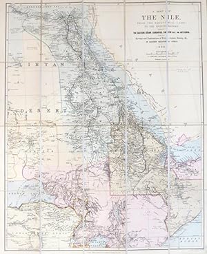
A Map of the Nile, from the equatorial lakes to the Mediterranean, embracing the eastern Sudan (Kordofan, Darfur &c.) and Abyssinia, with the Surveys and Explorations of Emin, Junker, Stanley, &c., in eastern equatorial Africa
Published by London: Edward Stanford, 1898
Seller: Bow Windows Bookshop (ABA, ILAB), Lewes, United Kingdom
Association Member: ABA ILAB PBFA
Seller rating 5 out of 5 stars

Map
US$ 207.14
US$ 29.50 shipping
Ships from United Kingdom to U.S.A.Quantity: 1 available
Add to basketColoured folding map on linen with dissections, map dimensions 64 x 51 cm, overall 68 x 56 cm, to a scale of 94 miles to the inch. Original cloth covers with a printed Stanford label, slightly darkened and soiled, the map in excellent condition.
-
Map of Explorations in Eastern Equatorial Africa Shewing the Herald "Up-Nile" and Stanley-Livingstone Expeditions
Published by [Glasgow: Maclure & Macdonald, ca. 1872], 1872
Seller: James Arsenault & Company, ABAA, Arrowsic, ME, U.S.A.
Association Member: ABAA ESA ILAB
Seller rating 5 out of 5 stars
Map
Lithograph on muslin, printed in black within rustic twig inner border and ornamental outer border printed in red; map measures 17" x 13.75" (including rustic border); overall dimensions: 28" x 22.5". CONDITION: Good, small hole in left margin, lightly damp-stained and toned, not fragile. An apparently unrecorded map depicting nineteenth-century expeditions to the African interior and primarily focused on contextualizing the then-ongoing expedition of David Livingstone, who became the subject of international speculation while he was unaccounted for in Africa. This intriguing "Map of Dr. Livingstone's Travels" highlights the fervor around African exploration that gripped the English-speaking world in the latter part of the nineteenth century. The titular explorer, David Livingstone, earned great fame as a result of his 186673 expedition to find the source of the Nile, during which his whereabouts were, for several years, unknown. He was ultimately located again in 1871 on the shores of Lake Tanganyika by a party led by Henry Morton Stanley. The map shows the eastern part of Africa centered on the Nile River as it flows northward from the African Great Lakes to its delta in Egypt. It depicts the physical geography of the region as it was known at the time, providing the names for rivers, lakes, mountains, settlements, and historic regions. A key identifies the expeditions of several African explorers, including those of Speke & Burton (1857), David Livingstone (1866), Samuel Baker (1869), Alvan Southworth (the "[New York] Herald Up Nile Expedition" (187172), and Henry Morton Stanley (1871). The text below the map contextualizes Livingstone's expedition and discoveries within the broader history of the search for the source of the Nile and other recent explorations. Scale is given in miles and longitude in degrees east of Greenwich. Overall, the map reflects an informed but imperfect knowledge of the region, and is thus a revealing transitional document in the pre-partition history of Africa. The interior of sub-Saharan Africa was one of the last regions of the world to be explored by Europeans, with several important expeditions taking place from the 1850s to the 1870s. These discoveries paved the way for the Partition of Africa, which culminated in the Berlin Conference of 188485 and saw nearly the entire continent divided among rival European powers. The quest to find the source of the Nile captivated geographers for millennia. John Hanning Speke's 1858 expedition established its outflow from Lake Victoria, although search for an even more distant source continued into the 1870s. David Livingstone (18181873) was a Scottish missionary who explored the interior of Africa across several major expeditions. Beginning in South Africa in 1841, Livingstone pushed northward into uncharted territory in the Kalahari in pursuit of converts. In 1853, he declared "I shall open up a path into the interior, or perish." Livingstone's next expedition that same year reached the Atlantic and brought him considerable fame in Britain, winning him the sponsorship of the British government. However, his 1863 expedition to the Zambezi region was marred by tragedyincluding the death of his wifeand disputes among the party. That voyage was recalled by British authorities. In 1866, Livingstone set out from Zanzibar on his final journey to find the source of the Nile, as depicted on this map. The expedition quickly ran into trouble, and several of his company defected, inventing a story that Livingstone had been killed by raiders. Later news, however, confirmed that Livingstone was still alive, although not heard from for several years, and his whereabouts became the subject of great international speculation. He was eventually located in 1871 in Ujiji (present-day Tanzania) by the Stanley search party. Upon seeing Livingstone, alive but in ill health, Stanley greeted him with the famous words: "Dr. Livingstone, I presume?" Livingstone refused to r.