Order Total (1 Item Items):
Shipping Destination:

Map of India and Ceylon (43 results)
Feedback
Skip to main search results
Search filters
Product Type
- All Product Types
- Books (23)
- Magazines & Periodicals (No further results match this refinement)
- Comics (No further results match this refinement)
- Sheet Music (No further results match this refinement)
- Art, Prints & Posters (1)
- Photographs (No further results match this refinement)
- Maps (19)
- Manuscripts & Paper Collectibles (No further results match this refinement)
Condition Learn more
Binding
Collectible Attributes
- First Edition (6)
- Signed (No further results match this refinement)
- Dust Jacket (No further results match this refinement)
- Seller-Supplied Images (31)
- Not Print on Demand (37)
Language (4)
Free Shipping
Seller Location
Seller Rating
-

India in 1875-76. the Visit of the Prince of Wales. a Chronicle of His Royal Highness's Journeyings in India, Ceylon, Spain, and Portugal ... with Map and Diaries.
Published by British Library, Historical Print Editions, 2011
ISBN 10: 1241158789 ISBN 13: 9781241158781
Language: English
US$ 36.19
Convert currencyUS$ 3.99 shipping within U.S.A.Quantity: Over 20 available
Add to basketCondition: New.
-
US$ 12.33
Convert currencyUS$ 13.30 shipping from United Kingdom to U.S.A.Quantity: 1 available
Add to basketCondition: Good. INDIA. Geological map. Tertiary Cretaceous Archaean Purana Gondwana 1929. Antique colour travel map; John Bartholomew & Son Ltd (1929). 17.5 x 22.0cm, 7 x 8.75 inches; this is a folding map. Condition: Good. The image shown may have been taken from a different example of this map than that which is offered for sale. The map you will receive is in good condition but there may be minor variations in the condition from that shown in the image. There is nothing printed on the reverse side, which is plain.
-
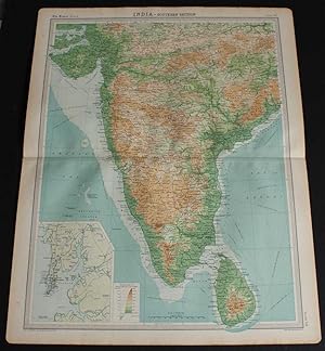
Map of "India - Southern Section" from the 1920 Times Survey Atlas (Plate 58) covering Mysore, Hyrerabad, Central Provinces, Ceylon (Sri Lanka), Kathainwar, Bombay, Baroda, Chota, Laccadive Islands, etc.
Published by The Times, London, 1920
Map First Edition
US$ 27.39
Convert currencyUS$ 19.28 shipping from United Kingdom to U.S.A.Quantity: 1 available
Add to basketSoftcover. Condition: Very Good. Dust Jacket Condition: No Dust Jacket. First Edition. Disbound single sheet with horizontal centre fold from the 1920 "The Times Survey Atlas of the World". Map is in colour and suitable for framing. Colour on both land and sea according to contour. Map at scale 1:4,000,000 with small inset map of Bombay at scale 1:340,000. Map covers; India (part), Mysore, Hyrerabad, Central Provinces, Ceylon (Sri Lanka), Colombo, Kathainwar, Bombay, Baroda, Chota, Coromandel Coast, Laccadive Islands, Bay of Bengal (part), Gulf of Cambay, Gulf of Manar, Arabian Sea (part), etc. Slightly darkened edges with occasional light foxing or staining in margins but sheet is otherwise clean and crisp. Item Type: Map. Single sheet map/chart which is suitable for framing and will be shipped rolled and in a cardboard tube. Quantity Available: 1. Shipped Weight: under 1 kg. Pictures of this item not already displayed here available upon request. Inventory No: 45020034035. All our books are sent by tracked mail.
-

The last home of mystery, by E. Alexander Powell; adventures in Nep�l together with accounts of Ceylon, British India, the native states, the Persian gulf, the Overland desert mail and the Baghdad railway. Illustrated with a map and with many photographs by the author.
Published by Garden City, New York : The Century Co. ; Garden City Publishing Company, Inc, [1929], 1929
Seller: Joseph Valles - Books, Stockbridge, GA, U.S.A.
Seller rating 5 out of 5 stars

Hardcover. Condition: Good. No Jacket. xv, 332 p. front., plates, ports. 23 cm. ; LCCN: 29-8016 ; OCLC: 408932 ; A Star Book ; yellow cloth ; no dustjacket ; Contents: The utmost INdian Isle -- Idols and Idyls -- Unclean gods -- The last stand of despotism -- In the shadow of the bloddy goddess -- I meet a dictator -- Let us journey to a lonely land I know -- With t he pilgrims to Pashpatti -- The forbidden country -- On the eaves of the world -- The golden cities of the vale -- At the courts of the princes -- Arabian nights and magic carpets -- With the overland desert mail ; spine sunned ; wear ; fly leaf foxed ; G. Book.
-
Map of 'India South and India North-East', Plate 28 disbound from 1959 Mid-Century Times Atlas of the World, Volume II, (South-West Asia and Russia) includes India, East Pakistan, Ceylon, Andaman Islands, Nicobar Islands
Published by The Times Publishing Company Ltd., London, 1959
US$ 38.35
Convert currencyUS$ 19.28 shipping from United Kingdom to U.S.A.Quantity: 1 available
Add to basketSoftcover. Condition: Fine. Dust Jacket Condition: No Dust Jacket. Mid-Century Edition. Single disbound map sheet from 'The Times Atlas of the World, Mid-Century Edition; Volume II Eurasia, suitable for framing. Map is in colour and has vertical centre fold. Approx. sheet size is 49 x 61cm. Sheet is clean, bright and crisp. Scale 1:4,000,000. Map shows relief, national and other boundaries, cities, town, rivers main roads, some tracks, railways, oil pipe lines, mangrove Swamps, main civil airports and other airfields etc. Inset maps of Andaman Island and Nicobar Island at 1:4,000,000 scale. Inset plans of Bombay and Madras showing main roads, green areas, railways etc. at 1:200,000 scale First printing of this edition. Quantity Available: 1. Shipped Weight: under 1 kg. Pictures of this item not already displayed here available upon request. Inventory No: 45022081062. All our books are sent by tracked mail.
-
US$ 20.55
Convert currencyUS$ 13.30 shipping from United Kingdom to U.S.A.Quantity: 2 available
Add to basketCondition: Good. 'The Gorgeous East'. India, Burma, Siam, Malaya & Ceylon. Indochina 1913 map. Antique map; J. Raeburn Middleton (1913). 18.5 x 24.0cm, 7.25 x 9.5 inches; this is a folding map. Condition: Good. There is nothing printed on the reverse side, which is plain.
-
US$ 20.55
Convert currencyUS$ 13.30 shipping from United Kingdom to U.S.A.Quantity: 3 available
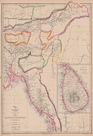
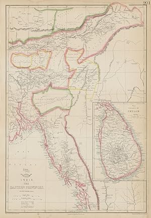
Add to basketCondition: Good. BRITISH INDIA 'Eastern Provinces'. Ceylon Burmah Tipperah. WELLER 1863 old map. Antique map with original outline colour; Engraved by Edwd. Weller (1863). 45.5 x 31.0cm, 18 x 12.25 inches. Condition: Good. The image shown may have been taken from a different example of this map than that which is offered for sale. The map you will receive is in good condition but there may be minor variations in the condition from that shown in the image. This map was coloured by hand at the time of publication, thus the colouration may vary slightly between different examples of the map; the colouring applied to the map you receive may differ slightly from that shown in the image. There is nothing printed on the reverse side, which is plain.
-

The Fauna of British India, including Ceylon and Burma. Mammalia. Vol. 3. Rodentia (in two parts). Part 1-2. With 54 Text-figures and a Coloured Map. With an appendix by M. L. Roonwal and B. Biswas. (Second Edition).
Published by Calcutta, Zoological Survey of India, 1961
Seller: WILFRIED MELCHIOR � ANTIQUARIAT & VERLAG, Spreewaldheide, Germany
Seller rating 4 out of 5 stars

US$ 47.73
Convert currencyUS$ 11.53 shipping from Germany to U.S.A.Quantity: 1 available
Add to basketXXX, 482; S. 483-884, XL-LII. Gr.-8�. Weinrote Orig.-Leinenb�nde mit R�ckengoldtitel. - Sehr guter Zustand. * Die Nagetiere von Indien und Nachbarl�nder. * (Ein Titel aus unserem Online-Katalog "Naturwissenschaften - Zoologie: Mammalogie").
-
US$ 21.91
Convert currencyUS$ 13.30 shipping from United Kingdom to U.S.A.Quantity: 1 available
Add to basketCondition: Good. SOUTHERN BRITISH INDIA & CEYLON. Protestant Mission Stations. Sri Lanka 1911 map. Antique colour missionary map; John G. Bartholomew & Co., Edinburgh (1911). 45.0 x 34.0cm, 17.75 x 13.25 inches; this is a folding map. Condition: Good. There is nothing printed on the reverse side, which is plain.
-
US$ 21.91
Convert currencyUS$ 13.30 shipping from United Kingdom to U.S.A.Quantity: 1 available
Add to basketCondition: Fair. BRITISH INDIA 'Eastern Provinces'. Ceylon Burmah Tipperah. WELLER 1862 old map. Antique map with original outline colour; Engraved by Edwd. Weller (1862). 45.5 x 31.0cm, 18 x 12.25 inches. Condition: Fair: Damp stain along top and right hand edges. Light spotting in margin. There is nothing printed on the reverse side, which is plain.
-

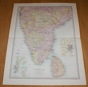
Map of India and Ceylon
Publication Date: 1887
Seller: Art Source International Inc., Boulder, CO, U.S.A.
Seller rating 2 out of 5 stars

-

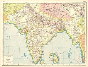
Map of India and Ceylon
Publication Date: 1885
Seller: Art Source International Inc., Boulder, CO, U.S.A.
Seller rating 2 out of 5 stars
-
Map of 'India, Physical and Political' - Sheet 45 disbound from the 1890 'The Library Reference Atlas of the World' including Ceylon (Sri Lanka), Nepal, Bhutan and modern day Bangladesh
Published by Macmillan and Co., London, 1890
First Edition
US$ 45.20
Convert currencyUS$ 19.28 shipping from United Kingdom to U.S.A.Quantity: 1 available
Add to basketSoftcover. Condition: Very Good. Dust Jacket Condition: No Dust Jacket. First Edition. Single disbound coloured map sheet, from John Bartholomew's Library Reference Atlas. Sheet is divided into to map panels showing the same area, one coloured to show 'Orographical Features' and one showing 'Political Divisions'. Suitable for framing. Approx size 35 x 46cm, vertical centre fold. Some foxing in margins, map is otherwise clean, crisp and bright. Area covered includes India, Sri Lanka (Ceylon), Napal, Bhutan, Andaman Islands, Nicobar Islands, the Maldives, and parts of Tibet, Myanmar (Burma) and Pakistan (Baluchistan). No dust jacket, as published. Quantity Available: 1. Shipped Weight: under 1 kg. Pictures of this item not already displayed here available upon request. Inventory No: 45021014037. All our books are sent by tracked mail.
-
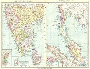
Southern India and Ceylon; The Malay Peninsula; Inset map of Madras; Colombo; Island of Singapore
Publication Date: 1907
Map
US$ 24.65
Convert currencyUS$ 13.30 shipping from United Kingdom to U.S.A.Quantity: 5 available
Add to basketCondition: Good. SOUTH INDIA. Sri Lanka; Malay Peninsula; Chennai; Colombo; Singapore 1907 map. Colour antique map. Scale 1:100,000; Scale 1:100,000; Harmsworth (1907). 36.5 x 48.5cm, 14.5 x 19 inches; this is a folding map. Condition: Good. There are images and/or text printed on the reverse side of the picture. In some cases this may be visible on the picture itself or around the margin of the picture.
-
Map of India (Section 3) covering southern India and Ceylon (Sri Lanka) including small inset plans of Madras and Bombay - Sheet 48 Disbound from the 1890 'The Library Reference Atlas of the World'
Published by Macmillan and Co., London, 1890
First Edition
US$ 46.57
Convert currencyUS$ 19.28 shipping from United Kingdom to U.S.A.Quantity: 1 available
Add to basketSoftcover. Condition: Very Good. Dust Jacket Condition: No Dust Jacket. First Edition. Single disbound coloured map sheet from John Bartholomew's Library Reference Atlas. Suitable for framing. Section 3 only of 3 covering India (as was in 1890). Approx size 46 x 35 cm, horizontal centre fold. Small closed tear in bottom right corner margin. Map is clean, crisp, clear and bright. Sheet covers southern India and includes: Ceylon (Sri Lanka), Colombo, Haidarabad, Madras, Bombay, Nagpur, Palk Strait, Coromandel Coast, Malabar Coast, Gulf of Manar, Kanker, Nasik, Poona, Mangalore, Vizagapatam, etc. Sheet contains small inset plans of Madras and Bombay. No dust jacket, as published. Quantity Available: 1. Shipped Weight: under 1 kg. Pictures of this item not already displayed here available upon request. Inventory No: 45020124017. All our books are sent by tracked mail.
-
Physical Map of the INDIAN EMPIRE from 1860's W. Swan Sonnenschein & Allen's Plastic School Atlas. 10 x 11.5 inch Relief map includes Himalayas, India, Ceylon and parts of Beloochistan, Afghanistan, Chinese Republic, Burmah.
Published by W. Swan Sonnenschein & Allen's Plastic School Atlas., London, England,, 1865
Language: English
Map
US$ 61.64
Convert currencyUS$ 20.74 shipping from United Kingdom to U.S.A.Quantity: 1 available
Add to basketNo Binding. Condition: Good. Physical Map of the INDIAN EMPIRE, A single unfolded sheet from W. Swan Sonnenschein & Allen's c1860s Plastic School Atlas. 10 x 11.5 inch Relief map includes Himalayas, India, Ceylon, Andaman Islands and parts of Beloochistan, Afghanistan, Chinese Republic, Burmah etc. Undated but believed to be 1860s. Light age discolouration around edges. Data sheet page attached to verso.
-
India, Southern part; Inset map of Bombay and Vicinity, Ceylon, Map of the Straits Settlements of Malay Peninsula
Publication Date: 1903
Map
US$ 31.50
Convert currencyUS$ 13.30 shipping from United Kingdom to U.S.A.Quantity: 2 available
Add to basketCondition: Good. INDIA SOUTH CEYLON. Bombay Malaysia Singapore.Shows key battles/dates 1903 map. Colour antique lithographic map; Britannica, Encyclopaedia (1903). 28.0 x 39.0cm, 11 x 15.5 inches; this is a folding map. Condition: Good. There is nothing printed on the reverse side, which is plain. The sites of important battles and their dates are marked on this map.
-
[FRAMED GLAZED MAP OF] INDIA (Southern Sheet) With an inset map of the South-Eastern Provinces of India (Hindu Chinese Countries or Further India). Including Ceylon and the Lakkadiv Islands, Andaman and Nicobar Islands. British Territory tinted Red, Protected States Yellow. Showing Railways and Canals. Sites of Battles 1803. Heights in English Feet. Sub Telegraph lines shown in blue. 6 scales.
Published by Engraved Printed and Published by W. & A.K. Johnston Edinburgh, 1883
Seller: Francis Edwards ABA ILAB, Hay on Wye, United Kingdom
Association Member: ABA ILAB PBFA
Seller rating 5 out of 5 stars
US$ 45.20
Convert currencyUS$ 22.61 shipping from United Kingdom to U.S.A.Quantity: 1 available
Add to basketColoured in outline, light central crease, glazed using acrylic with pine frame, measuring 65cm x 53cm including frame, in very good order. From 'The Royal Atlas of Modern Geography' Exhibiting in a Series of Entirely Original and Authentic Maps, the Present Condition of Geographical Discovery and Research in the Several Countries, Empires. and States of the World. Additional postage may be necessary US$44.
-
![Seller image for The last home of mystery. Adventures in Nepal together with accounts of Ceylon, British India, the Native States, the Persian Gulf, the Overland Desert Mail and the Baghdad Railway / Illustrated with a map and with many photos, by the author. 1929 [LeatherBound] for sale by S N Books World](https://pictures.abebooks.com/inventory/md/md32213705076.jpg)
The last home of mystery. Adventures in Nepal together with accounts of Ceylon, British India, the Native States, the Persian Gulf, the Overland Desert Mail and the Baghdad Railway / Illustrated with a map and with many photos, by the author. 1929 [LeatherBound]
Publication Date: 2025
Language: English
LeatheBound. Condition: New. Leatherbound edition. Condition: New. Leather Binding on Spine and Corners with Golden leaf printing on spine. Bound in genuine leather with Satin ribbon page markers and Spine with raised gilt bands. Pages: 416. A perfect gift for your loved ones. Reprinted from 1929 edition. NO changes have been made to the original text. This is NOT a retyped or an ocr'd reprint. Illustrations, Index, if any, are included in black and white. Each page is checked manually before printing. As this print on demand book is reprinted from a very old book, there could be some missing or flawed pages, but we always try to make the book as complete as possible. Fold-outs, if any, are not part of the book. If the original book was published in multiple volumes then this reprint is of only one volume, not the whole set. IF YOU WISH TO ORDER PARTICULAR VOLUME OR ALL THE VOLUMES YOU CAN CONTACT US. Resized as per current standards. Sewing binding for longer life, where the book block is actually sewn (smythe sewn/section sewn) with thread before binding which results in a more durable type of binding. Language: English Pages: 416.
-
![Seller image for The last home of mystery, by E. Alexander Powell; adventures in Nep�l together with accounts of Ceylon, British India, the native states, the Persian gulf, the Overland desert mail and the Baghdad railway. Illustrated with a map and with many photographs by the author. 1929 [LeatherBound] for sale by S N Books World](https://pictures.abebooks.com/inventory/md/md32213285032.jpg)
The last home of mystery, by E. Alexander Powell; adventures in Nep�l together with accounts of Ceylon, British India, the native states, the Persian gulf, the Overland desert mail and the Baghdad railway. Illustrated with a map and with many photographs by the author. 1929 [LeatherBound]
Publication Date: 2025
Language: English
LeatheBound. Condition: New. Leatherbound edition. Condition: New. Leather Binding on Spine and Corners with Golden leaf printing on spine. Bound in genuine leather with Satin ribbon page markers and Spine with raised gilt bands. Pages: 420. A perfect gift for your loved ones. Reprinted from 1929 edition. NO changes have been made to the original text. This is NOT a retyped or an ocr'd reprint. Illustrations, Index, if any, are included in black and white. Each page is checked manually before printing. As this print on demand book is reprinted from a very old book, there could be some missing or flawed pages, but we always try to make the book as complete as possible. Fold-outs, if any, are not part of the book. If the original book was published in multiple volumes then this reprint is of only one volume, not the whole set. IF YOU WISH TO ORDER PARTICULAR VOLUME OR ALL THE VOLUMES YOU CAN CONTACT US. Resized as per current standards. Sewing binding for longer life, where the book block is actually sewn (smythe sewn/section sewn) with thread before binding which results in a more durable type of binding. Language: English Pages: 420.
-
Map of India With Ceylon, Burma, & Baluchistan. In Contour Colouring Showing Roads, Airports Etc. Scale 1:4,000,000
Published by John Bartholomew, Edinburgh.
Map
US$ 61.64
Convert currencyUS$ 29.26 shipping from United Kingdom to U.S.A.Quantity: 1 available
Add to basketSoft cover. Condition: Very Good. No date of publication but stated, "By Appointment to H.M. the King", so presumably war time issue, 1940's. Very good condition. One or two cross folds imperceptibly reinforced with transparent archival tissue. A very good example indeed. Size, 77cm x 1 metre. When folded 13 x 22cm. Linen backed.
-
East India: New Tariff of India / Grants of Land in Deyrah Dhoon, North West Provinces of Bengal / Reports respecting the Paumben Passage, Navigation of Palk`s Straits and the Gulf of Manas (with folding map) / Visit at the Expense of the British Government in 1858 of Deputies of the King of Burmah to view the Tooth of Budh in Ceylon / Amount of Capital raised by each East Indian Railway Company (British Parliamentary Paper - Blue Book),
Published by London, Her Majesty`s Stationary Office,, 1859
Language: English
Seller: Books and Beaches, Anna Bechteler, Icking, Germany
Seller rating 5 out of 5 stars
First Edition
US$ 89.49
Convert currencyUS$ 32.44 shipping from Germany to U.S.A.Quantity: 1 available
Add to basketCondition: Sehr gut. Disbound, 18 + 60 + 33 (and folding map) + 9 + 4 pages, no wrappers, very good condition. 5 official India papers bound together. The folding map of the gulf of Manas, today gulf of Mannar, part of the Indian Ocean betweeen southern India and Sri Lanka - maps in the blue books are rare. Sprache: Englisch Gewicht in Gramm: 550.
-
1844 BEAUTIFUL Huge Color MAP of INDIA Ceylon Ganges Bengal Hindustan ATLAS
Published by London : Published by the Society, and Chapman and Hall, 1844., 1844
Map First Edition
No Binding. Condition: Near Fine. 1st Edition. 1844 BEAUTIFUL Huge Color MAP of INDIA Ceylon Ganges Bengal Hindustan ATLAS From "Society for Diffusion of Useful Knowledge" A beautifully hand-colored map from the 1844 printing of "Society for the Diffusion of Useful Knowledge" The Society for the Diffusion of Useful Knowledge (SDUK), founded in 1826, and wound up in 1848, was a Whiggish London organisation that published inexpensive texts intended to adapt scientific and similarly high-minded material for the rapidly expanding reading public. It was established mainly at the instigation of Lord Brougham with the objects of publishing information to people who were unable to obtain formal teaching, or who preferred self-education. Engraver: J & C Walker Atlas title: Maps of the Society for the Diffusion of Useful Knowledge. Map title: India, XII. Published: London : Published by the Society, and Chapman and Hall, 1844. Language: English Notes & contents: Originally from the David Rumsey Collection FREE SHIPPING WORLDWIDE Wear: wear as seen in photos Publisher: London : Published by the Society, and Chapman and Hall, 1844. Size: ~13.5in X 16in (33cm x 41cm).
-

Map of India with Ceylon, Burma & Baluchistan. In Contour Colouring, showing roads, airports, etc. Scale 1 : 4,000,000.
Published by Bartholomew & Son Edinburgh., 1930
Language: German
Seller: Antiquariat im Schloss, Schwaigern, D, Germany
Seller rating 5 out of 5 stars
US$ 44.15
Convert currencyUS$ 40.54 shipping from Germany to U.S.A.Quantity: 1 available
Add to basketpaperback. 77 x 100 cm; 32 Segments mounted on cloth. A little bit knocked and browned; 1 larger tear at folding. Not listed by Bonacker. Sonst guter Zustand. Sprache: Deutsch Gewicht in Gramm: 550.
-
US$ 57.53
Convert currencyUS$ 13.30 shipping from United Kingdom to U.S.A.Quantity: 2 available
Add to basketCondition: Good. BRITISH INDIA RAILWAYS.broad medium narrow gauge.Pakistan Burma Ceylon 1920 map. Vintage colour map; Harmsworth (1920). 34.0 x 45.0cm, 13.25 x 17.5 inches. Condition: Good. This map was originally printed as two separate pages which have been professionally joined to form a single sheet. There is interesting related text and images printed on the reverse side of the picture. The paper is thick, and the verso text does not show through to the front of the map.
-
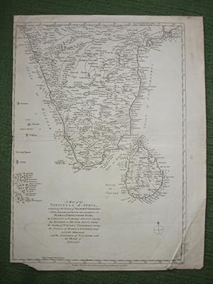
A Map of the Peninsula of India, containing the Coasts of Malabar & Coromandel, with the English and French Settlements at Madras, Pondicherry &C, &C; . and the Kingdom of Vislapoor, with the Island of Ceylon
Published by John Bew, London, 1781
Map
US$ 82.18
Convert currencyUS$ 21.28 shipping from United Kingdom to U.S.A.Quantity: 1 available
Add to basketcopper engraved uncoloured map, 270 x 380 mm (10.63 x 14.96 inches), includes the Maldives, crease bottom left and right, cropped close to border on right side and partial tear not affecting border bottom left, small tear (30 mm) on left of centre fold, otherwise good clean condition. This is an original antique map. We do not sell reproductions or facsimiles.
-
MAP OF INDIA WITH CEYLON, BURMA & BALUCHISTAN. In Contour Colouring Showing Road
Seller: RARE ORIENTAL BOOK CO., ABAA, ILAB, Aptos, CA, U.S.A.
Seller rating 4 out of 5 stars
Edinburgh circa. [1920's], Bartholomew. Grey card covers, articulating map, linen backed, folds down to 13 x 21.5 cm., opens to 102 x 78 cm., with key, in English, excellent pre-World War II work, with inset of Afghanistan. . * An excellent map, suitable for display. Shows all of Burma to the East and all of India, Afghqanistan & Baluchistan to the West. Tibet to the North, and to the end of India and the tip of Ceylon to the South, all of the Bay of Bengal, the Andaman Islands. Nicely done, shows all major rivers, mountains & cities, towns, main & secondary roads, railways, canals, boundaries, difficulties of passage, milage & dist- ances. The inset shows Afghanistan and the now Pakistan area before Pakistan was designated a state. Shows from Kabul to Soda Plains.
-

Map of Hindustan or Hindostan, India with Island of Sri Lanka or Ceylan / Ceylon
Published by Paris, 1764
Seller: Trillium Antique Prints & Rare Books, Franklin, TN, U.S.A.
Seller rating 4 out of 5 stars
Art / Print / Poster First Edition
Condition: Fine. This detailed map is from Jacques-Nicolas Bellin's Le Petit Atlas Maritime. This first edition work was published in Paris by Bellin in 1764. The atlas had included plenty of new material as well as reduced engravings from his previous atlases.Jacques-Nicolas Bellin (1703-1772) was one of the most noted mapmakers of the 1700s. He served as the hydrographer to the French Navy at the age of 18 and was eventually named the Official Hydrogapher of the French King. He produced numerous maps and atlases throughout his career, and helped establish France as a leading source of precise cartography. --- The work is in very good to excellent condition overall. There may be some faint offset or toning at the folds in this work; however generally very clean, presented well. There may be a few minor imperfections to be expected with age. Please review the image carefully for condition and contact us with any questions. --- Paper Size ~ 8 1/2" by 13".
-
1863 Map INDIA THE EASTERN PROVINCES Island of Ceylon by Edward Weller (DA185)
Seller: Antique Paper Company, ASHFORD, KENT, United Kingdom
Seller rating 2 out of 5 stars
US$ 54.79
Convert currencyUS$ 7.98 shipping from United Kingdom to U.S.A.Quantity: 1 available
Add to basketListing Template 2018 Home About Us View Feedback Contact Us 1863 Map INDIA THE EASTERN PROVINCES Island of Ceylon by Edward Weller (DA185)Click image to enlargeDescription1863A fine large original antique map titledINDIA THE EASTERN PROVINCES.The Island of CEYLONEngraved by Edward Weller and published for 'The Distatch Atlas' at the Weekly Dispatch Office, Fleet Street, London. Outline original hand colour. Measuring approx 49cm x 33cm with central fold as issued.Edward Weller (1819-1884)was a London based engraver, cartographer and publisher working from offices in Red lion Square and later in Bloomsbury. Amongst his considerable portfolio were various atlases, many of which focused on the educational publishing market. Having established his credentials as an engraver of finely detailed works, he sold maps to be published in a number of regular magazines and pamphlets, perhaps the best known being The Dispatch Atlas; a compilation of maps Weller had already published in The Weekly Dispatch. Although Weller usually engraved the maps himself, he did work in partnership with others, notibly John Dower for this Atlas. Weller also published The Crown Atlas in 1871,The Dispatch Atlas featured well over 100 superbly detailed steel plate engraved maps, usually with simplistic, single colour outline hand colouring and a distinctive header style. Most English counties featured, some of which were divided onto separate sheets, affording space to engrave in greater detail. The maps of North and South Devonshire for example include such details as individual property names, as do those of Norther and Southern parts of Hampshire.After Weller's death in 1884, many of these highly detailed plates were sold onto other map makers, include George Bacon, who whist retaining the level of details, expanded the printing area of each plate, adding more precise and varied hand colouring in keeping with the final decades of the century. View Our Categories Decorative Prints World Wide Maps Scotland Maps Architecture Design England Maps Royalty About UsWe specialise in selling all items that can be considered to be Antique Paper. * PRINTS * MAPS * HISTORICAL DOCUMENTS * POSTAL HISTORY * BOOKS * POSTERS * STAMPS * POSTCARDS * EPHEMERA And anything else that is considered Antique and made of Paper. ALL OF OUR ITEMS ARE ORIGINAL ANTIQUES - NOT MODERN COPIES. We are also very keen buyers of anything similar and especially after better collections, original archives, whole libraries and better single items and have £250,000 in cash funds at anyone time to buy the right items. Contact UsIf you have any questions then please do not hesitate to contact us through the eBay messaging system. Feedback We will always help you to have a 100% positive happy buying experience. Contact us if you are unhappy about any aspect of your purchase from us. We only want five star feedback from you so buy with confidence.
-
![Seller image for Carte de la Partie Inf�rieure de l'Inde en de �� du Gange, contenant l'Isle de Ceylan, les C�tes de Malabar et de Coromandel avec le Pays compris entre ces C�tes [Map of the Lower Part of India on this side of the Ganges, containing the Island of Ceylon, the Coasts of Malabar and Coromandel with the Country between these Coasts] [Asia] [Sri Lanka] for sale by Blue Whale Books, ABAA](https://pictures.abebooks.com/inventory/md/md30906158173.jpg)
Carte de la Partie Inf�rieure de l'Inde en de �� du Gange, contenant l'Isle de Ceylan, les C�tes de Malabar et de Coromandel avec le Pays compris entre ces C�tes [Map of the Lower Part of India on this side of the Ganges, containing the Island of Ceylon, the Coasts of Malabar and Coromandel with the Country between these Coasts] [Asia] [Sri Lanka]
Published by Jean-Leonard Pellet, Geneve, 1780
Seller: Blue Whale Books, ABAA, Charlottesville, VA, U.S.A.
Seller rating 4 out of 5 stars
Condition: Very Good. From Raynal's Histoire Philosophique et Politique. Center fold as issued. Always securely packed and dispatched rapidly. Professional sellers of antiquarian books, maps and prints since 1994. Satisfaction guaranteed. Copper Engraving. Image 8.25" x 12.25"; sheet 10.25" x 14".