Order Total (1 Item Items):
Shipping Destination:

Map Peking, Used (80 results)
Skip to main search results
Search filters
Product Type
- All Product Types
- Books (42)
- Magazines & Periodicals (No further results match this refinement)
- Comics (No further results match this refinement)
- Sheet Music (No further results match this refinement)
- Art, Prints & Posters (3)
- Photographs (No further results match this refinement)
- Maps (35)
- Manuscripts & Paper Collectibles (No further results match this refinement)
Condition Learn more
- New (No further results match this refinement)
- As New, Fine or Near Fine (10)
- Very Good or Good (33)
- Fair or Poor (1)
- As Described (36)
Binding
Collectible Attributes
- First Edition (6)
- Signed (No further results match this refinement)
- Dust Jacket (2)
- Seller-Supplied Images (60)
- Not Print on Demand (80)
Language (4)
Free Shipping
- Free Shipping to U.S.A. (No further results match this refinement)
Seller Location
Seller Rating
-

Peking (World City Map S.)
Language: English
Published by GeoCenter International Ltd, 1994
ISBN 10: 3575333696 ISBN 13: 9783575333698
Condition: Very Good. Most items will be dispatched the same or the next working day. A copy that has been read, but is in excellent condition. Pages are intact and not marred by notes or highlighting. The spine remains undamaged.
-

Paper cut in China - Facial makeup of Peking Opera. Text english and chinese. 8 papercuts in full color protected with clear mylar + other color illustrations, in a illustrated map. Clean good book.
Published by n.a., 1990
Seller: Fabri Antiquariat Dr. J�rgen Aschoff, Ulm, BW, Germany
Seller rating 4 out of 5 stars

Paper cut in China - Facial makeup of Peking Opera. Text english and chinese. 8 papercuts in full color protected with clear mylar + other color illustrations, in a illustrated map. Clean good book. text 19 S.
-
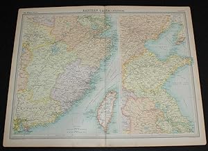
Map of Eastern China from the 1920 Times Survey Atlas (Plate 64) including Hankow, Anking, Nanking, Hangchow, Shanghai, Ningpo, Foochow, Canton, Hong Kong, Peking, Tientsin, Tsinan, Amoy and Taiwan (Formosa)
Published by The Times, London, 1920
Map First Edition
US$ 22.09
US$ 19.44 shipping
Ships from United Kingdom to U.S.A.Quantity: 1 available
Add to basketSoftcover. Condition: Very Good. Dust Jacket Condition: No Dust Jacket. First Edition. Disbound single sheet with vertical centre fold from the 1920 "The Times Survey Atlas of the World". Map is in colour and suitable for framing. Province boundaries are marked in different colours with colour infill in matching paler colours, seas are coloured blue. Map at scale 1:3,000,000 and split over two continuation panels. Map covers Kiangsi, Anhwei, Shantung, Fukien, Kwangtung, Chekiang, Chinli, Kiangsu, Hankow, Anking, Nanking, Hangchow, Shanghai, Ningpo, Foochow, Canton, Hong Kong, Peking, Tientsin, Tsinan, Amoy, Taiwan (Formosa), Gulf of Pechihli, Gulf og Liaotung, etc. Slightly darkened edges with occasional light foxing in margins, sheet is otherwise clean and crisp. Item Type: Map. Single sheet map/chart which is suitable for framing and will be shipped rolled and in a cardboard tube. Quantity Available: 1. Shipped Weight: under 1 kg. Pictures of this item not already displayed here available upon request. Inventory No: 45020034043. All our books are sent by tracked mail.
-

Paperback. Condition: Good. printers code 12071.12 published late 1960's ?
-
Map of 'North China and Mongolia' - Plate 21 disbound from 1958 Mid-Century Times Atlas of the World, including Ulan-Ude, Chita, Ulan Bator, Peking, Tientsin, Tsingtao and Lanchow
Published by The Times Publishing Company Ltd., London, 1958
US$ 28.72
US$ 19.44 shipping
Ships from United Kingdom to U.S.A.Quantity: 1 available
Add to basketSoftcover. Condition: Very Good. Dust Jacket Condition: No Dust Jacket. Mid-Century Edition. Single disbound map sheet from 'The Times Atlas of the World, Mid-Century Edition; Volume I The World, Australia & East Asia' suitable for framing. Map is in colour and has vertical centre fold. Approx sheet size is 49 x 61cm. Sheet is clean, bright and crisp. Map covers part of north China, Mongolia and the Russian border north of Mongolia. Included are Ulan-Ude, Chita, Ulan Bator, Peking (Beijing), Tientsin, Tsingtao, Lanchow, Barkol and part of the Sinkiang Uighur Region and the Inner Mongolian Region. Small inset plan of Peking in bottow left corner. Road and railway routes are shown. First printing of this edition. Quantity Available: 1. Shipped Weight: under 1 kg. Pictures of this item not already displayed here available upon request. Inventory No: 45021024045. All our books are sent by tracked mail.
-
Falk Plan (No. 270): Map of Peking - China patentfolded (English/French/German edition)
Language: English
Published by Falk; Hamburg, Berlin, Den Haag, London, 1973
Kein Einband. Condition: Befriedigend. Paperback. Folded maps with index of streets, lists of places of interest, vocabulary etc. Traces of use to cover, corners bumped, maps very good, no traces of use, clean, no inscriptions, no markings, in stock, sofort lieferbar.
-

1901 Antique Print - MAP CHINA Capital Beijing Peking Railways (29)
Seller: Antique Paper Company, ASHFORD, KENT, United Kingdom
Seller rating 2 out of 5 stars

Listing Template 2018 Home About Us View Feedback Contact Us 1901 Antique Print - MAP CHINA Capital Beijing Peking Railways (29)Click image to enlargeDescription1901 July 13Original Antique Print taken from The Graphic:New Capital of China.Overall size of thisprint is approx 14cm x 28cm with large margins, perfect for mounting for home, business, interior decorators, hotels, pubs, boardrooms and restaurants.All our prints are ORIGINALS ANTIQUES AND GUARANTEED TO BE AS DATED. Please note we are offering an ANTIQUE PRINT on this listing unless otherwise described.These prints are taken from the THE GRAPHIC and in many cases, there will also be text on the reverse of the image side.The Graphic was first published in 1869, founded by William LusonThomasand was a weekly newspaper reporting details of local, UK and worldwide events and stories.The Graphicis known for its coverage of of the following subjects:The Wars, Ships, Boats, Guns, Sailing, Portraits, Fine Art, Old and Antique Prints, Wood Cut, Wood Engravings, Early Photographs, Victorian Life, Victorian Culture, Kings, Queens, Royalty, Travels, Adventures, Natural History, Birds, Fish, Mammals, Fishing, Hunting, Shooting, Fox Hunting, Sprts including Tennis, Cricket, Football, Horse Racing etc.WE ARE HAPPY TO COMBINE POSTAGE FOR UP TO 10 ITEMS FOR NO ADDITIONAL CHARGE OVER THE SINGLE ITEM POSTAGE COST.PaymentWe prefer payment via PAYPAL or BANK TRANSFER. Payment can also be made by cheque drawn on UK Bank.ShippingWe usually ship within 3 working days of order. We are very happy to combine many items for a single postal charge.About UsAntique Paper Company are established dealers in Antique Maps Prints, Stamps, Postal History, Antiquarian Books along with Post Cards, Old Posters, Archives, Manuscripts, Ephemera etc.We are keen buyers regularly travel throughout the UK Europe in search of opportunites to buy. Cash funds of up to and#163;250,000 are available immediately for the right opportunities. We work closely with Libraries Solicitors/probate situations where they are looking for disposal options and seek better single items to large quantities and also Specialised Collections of almost any genre.Please do not hesitate to contact us with details of any items you might have for sale. View Our Categories Decorative Prints World Wide Maps Scotland Maps Architecture Design England Maps Royalty About UsWe specialise in selling all items that can be considered to be Antique Paper. * PRINTS * MAPS * HISTORICAL DOCUMENTS * POSTAL HISTORY * BOOKS * POSTERS * STAMPS * POSTCARDS * EPHEMERA And anything else that is considered Antique and made of Paper. ALL OF OUR ITEMS ARE ORIGINAL ANTIQUES - NOT MODERN COPIES. We are also very keen buyers of anything similar and especially after better collections, original archives, whole libraries and better single items and have and#163;250,000 in cash funds at anyone time to buy the right items. Contact UsIf you have any questions then please do not hesitate to contact us through the eBay messaging system. Feedback We will always help you to have a 100% positive happy buying experience. Contact us if you are unhappy about any aspect of your purchase from us. We only want five star feedback from you so buy with confidence.
-

"Plan de la Ville de Peking" - Peking Bejing China Chine Plan Karte map carte
Language: French
Published by Paris, 1750
Seller: Antiquariat Steffen V�lkel GmbH, Seubersdorf, Germany
Seller rating 5 out of 5 stars

Map
OriginalKupferstich-Karte von Bellin von ca. 1750. -- Blattmasse ca.25 x19 cm. -- gut erhalten. || Original copper engraved map by Bellin from circa 1750. -- in very good condition. // Wir, das Antiquariat Steffen V�lkel, kaufen und verkaufen alte B�cher, Handschriften, Zeichnungen, Autographen, Grafiken und Fotografien. Wir sind stets am Ankauf von kompletten Bibliotheken, Sammlungen und Nachl�ssen interessiert. Sprache: Franz�sisch Gewicht in Gramm: 10.
-

1904 Original Antique Map Showing a Route from Peking to Tsitsihar, China
Seller: Staffordshire Curios, Haughton, United Kingdom
Seller rating 2 out of 5 stars
Art / Print / Poster
US$ 24.84
US$ 20.04 shipping
Ships from United Kingdom to U.S.A.Quantity: 1 available
Add to basketAtlas Map. A very attractive map/survey, originally extracted from a 1904 print of The Geographical Journal, published by The Royal Geographical Society, LondonApprox total paper size is 40 x 29cmMap is in good condition for age with some general light handling wear with age in places but nothing major. Some general very light markings towards top right corner. Please note this is a folding map. Right hand fold is very small, so some general light creasing and small tears to folds.See photo.Seller ref: GeoSocB2 ; 8vo 8" - 9" tall.
-
Stanford's Map of South Eastern Asia from Peking to Singapore
Language: English
Published by Edward Stanford, London, 1883
Map
Hardcover. Condition: Very Good. Folding map, linen backed approx 27" x 22" in the cloth binding with paper label on the cover, dated 1883 at the base. The cloth is lightly worn, the map is in near fine condition with no browning to the linen or wear. Scarce.
-
Tourist map of Peking
Published by S.l., s.n 1972, 1972
Seller: Antiquarian Bookshop Klikspaan, Leiden, Netherlands
Seller rating 5 out of 5 stars
In illustrated cover.
-
paperback. Condition: Good. Chinese Peking Opera. English. art paper printed. multi-map.
-

"Plan de la Ville de Peking" - Peking Bejing China Chine Plan Karte map carte
Language: French
Published by Paris, 1750
Seller: Antiquariat Steffen V�lkel GmbH, Seubersdorf, Germany
Seller rating 5 out of 5 stars
Map
OriginalKupferstich-Karte von Bellin von ca. 1750. -- Blattmasse ca.25 x19 cm. -- gut erhalten. || Original copper engraved map by Bellin from circa 1750. -- in very good condition. // Wir, das Antiquariat Steffen V�lkel, kaufen und verkaufen alte B�cher, Handschriften, Zeichnungen, Autographen, Grafiken und Fotografien. Wir sind stets am Ankauf von kompletten Bibliotheken, Sammlungen und Nachl�ssen interessiert. Sprache: Franz�sisch Gewicht in Gramm: 10.
-
Beijing Environs Qing Empire China Great Wall Peking c. 1870's Monrocq map
Publication Date: 1870
Seller: RareMapsandBooks, Dover, NH, U.S.A.
Seller rating 4 out of 5 stars
Map
Condition: good. Environs de Pekin.(Old Maps, 19th Century Maps, Asia, Qing Empire, China, Pekin, Beijing, Great Wall). Issued c. 1870's, Paris by Monrocq. Engraved by Erhard. Late 19th century color lithographed map. Well preserved, nice looking example with pleasing age patina. Original fold lines as issued. Sheet Measures c. 9 3/4" H x 9 1/4" W. Printed� Area Measures c. 6" H x 8" W. Cartographic Reference (s):Tooley's Dictionary of Mapmakers, vol. 3.[R32969].
-
paperback. Condition: Good. Climbing set Fly. Swallow - Shandong Province. the second best screenplay. radio. TV. award-winning election drama. Peking Opera Spring and Autumn map.
-
China Qing Empire Beijing Peking Shanghai Macao Taiwan Hong Kong 1882 map
Publication Date: 1882
Seller: RareMapsandBooks, Dover, NH, U.S.A.
Seller rating 4 out of 5 stars
Map
Condition: good. China.(Asia, China, Qing Empire, Beijing, Peking, Shanghai, Canton, Hong Kong, Taiwan, Macao). Issued 1882, Edinburgh by Blackie & Son. Very detailed late 19th century color lithographed map. Well preserved, nice looking example with pleasing age patina. Original center fold as issued. Sheet Measures c. 15" x 22". Engraved Area Measures c. 13 1/2" x 19 3/4". Cartographic Reference (s):Tooley's Dictionary of Mapmakers, vol. 1.[R23167].
-
China Qing Empire Beijing Peking Macao Shanghai 1883 Blackie map
Publication Date: 1883
Seller: RareMapsandBooks, Dover, NH, U.S.A.
Seller rating 4 out of 5 stars
Map
Condition: good. China.(Asia, China, Qing Empire, Sichuan, Guangxi, Guangdong, Shangdon, Henan, Beijing, Macao, Hong Kong, Shanghai, Taiwan). Issued 1883, Edinburgh by Blackie & Son. Drawn & engraved by Edw. Weller. Detailed 19th century color lithographed map. Well preserved, nice looking example with pleasing age patina. Original center fold as issued. Sheet Measures c. 15" x 22". Engraved Area Measures c. 13 1/2" x 19 3/4". Cartographic Reference (s):Tooley's� Dictionary of Mapmakers, vol. 1.[R23281].
-
paperback. Condition: Good. Peking Opera Q (facsims 12 32 mask color opera map. Edition printed. Nearly ten products).
-
Qing Empire China Tibet Beijing Peking Canton 1866 A.J. Johnson map
Publication Date: 1866
Seller: RareMapsandBooks, Dover, NH, U.S.A.
Seller rating 4 out of 5 stars
Map
Condition: good. Johnson's China.(Asia, Qing Empire, China, Tibet, Beijing, Peking, Canton, Shanghai, Hong Kong, Macao, Taiwan, Formosa, Szechuan). Issued 1866, New York by A. J. Johnson. Uncommon mid 19th century lithographed map, with original hand color. Nice looking example, paper well age toned, pleasing age patina, light soiling and small scattered spotting, any minor age flaws easy to overlook or forgive. Sheet Measures c. 18" H x 14" W. Cartographic Reference (s):Tooley's Dictionary of Mapmakers, vol. 2, pp. 443[R25646].
-
paperback. Condition: Good. Ship out in 2 business day, And Fast shipping, Free Tracking number will be provided after the shipment.Pub Date: Unknown Publisher: Unknown scattered pages missing.Four Satisfaction guaranteed,or money back.
-

Peking City Map
Published by Paris, 1746
Seller: Trillium Antique Prints & Rare Books, Franklin, TN, U.S.A.
Seller rating 2 out of 5 stars
Art / Print / Poster
Condition: Fine. This fine engraving is from Antoine-Francois Prevost d'Exiles's Histoire G� n� rale des Voyages, ou nouvelle collection de toutes les relations de voyages par mer et par terre, qui ont � t� publi� es jusqu'� present dans les diff� rentes langues de toutes les nations connues. The work was published by Chez Didot in Paris in 1746. The plates and maps were by Cochin fils, Tardieu, B. L. Prevost and others.It was an expansive work that referenced China, the East Indies, Asia, the Americas, early Austrlian voyages, New Guinea, Palau Islands, Africa, and voyages in the Pacific including those of Magellan, Schouten, and Le Maire, Drake, Sarmiento, Cavendish, Spilbergen, Narborough, Rogers, Cowley, Frazier, and Anson. The work included particularly full accounts are given of the Dutch and French voyages to the East Indies, voyages to China, and the British East India Company's voyages to India and Ceylon. (Hill) --- Overall Very Good to Excellent. There can be some very light image or text offset with this work. There may be a few minor imperfections to be expected with age. Please review the image carefully for condition and contact with any questions.
-
Tourist Map of Peking.
Published by Peking Publishing House., Peking., 1959
Seller: Asia Bookroom ANZAAB/ILAB, Canberra, ACT, Australia
Association Member: ANZAAB ILAB
Seller rating 5 out of 5 stars
Broadside, 63 x 53cm folding to 18 x 14cm, a total of ten coloured maps. Somewhat worn along folds, with few cellotape repairs by a prior owner, a good copy. An interesting collection of maps of Peking dating to the tenth anniversary of the founding of the People's Republic of China and the year following the launch of the economic and social policies of the Great Leap Forward. On one side is a nine panel map "Sketch Map of Peking Streets," plus three smaller transportation maps (Communications in Peking's Outskirts plus City Bus Lines and Tram and Trolley Bus Routes; on the other side are maps of: the Imperial Palace Museum, Chungshan Park & Working People's Cultural Palace,'; Peihai Park; Yi Ho Yuan (the Summer Palace); Tien Tan 9the Temple of Heaven); Hsiangshan; and the Peking Zoo.
-
China Qing Empire Peking Beijing Nanking Taiwan Hong Kong 1809 hand colored map
Publication Date: 1809
Seller: RareMapsandBooks, Dover, NH, U.S.A.
Seller rating 4 out of 5 stars
Map
Condition: good. China.(Old Maps, Asia, China, Qing Empire, Beijing, Peking, Hong Kong, Taiwan, Macao, Canton, Nanking). Issued 1809, London by Sherwood, Neely, & Jones. Early 19th century engraved map with attractive hand color. Remains a nice looking example with a pleasing age patina. Any age flaws mostly minor and easy to overlook or forgive. Sheet Measures c. 10 1/2" H x 8" W. Engraved Area Measures c. 9 1/2" H x 7 1/2" W. Cartographic Reference (s):Tooley's Dictionary of Mapmakers, vol. 1.[B13061].
-
Qing Empire China Peking Beijing Hong Kong Macao Taiwan 1876 A. & C. Black map
Publication Date: 1876
Seller: RareMapsandBooks, Dover, NH, U.S.A.
Seller rating 4 out of 5 stars
Map
Condition: good. China.(Asia, Qing Empire, China, Hainan, Formosa, Taiwan, Peking, Beijing, Hong Kong, Macao, Shanghai). Issued 1876, Edinburgh by A. & C. Black. Late 19th Century color lithographed� map. Well preserved, nice looking example with pleasing age patina. Original center fold as issued. Sheet Measures c. 17 1/2" H x 24 1/2" W. Engraved Area Measures c. 16 1/2" H x 20 1/2" W. Cartographic Reference (s):Tooley's Dictionary of Mapmakers, vol. 1.[R25498].
-
Guide to Peking and its Environs Near and Far (2nd ed.1924, with the large colour folding map, 'Plan of Peking Inside its Walls')
Published by Tientsin Press, Peking, 1924
Seller: Muir Books [Robert Muir Old & Rare Books], PERTH, WA, Australia
Association Member: ANZAAB ILAB
Seller rating 5 out of 5 stars
Pictorial Cloth Boards. 2nd Revised. Revised (2nd) ed., octavo, pp.(xiv), 237, (ii), (xii, adverts), ex-lib stamp to recto of t.p., owner's stamp to dedication page and book-plate to front paste-down, profusely illustrated with b&w plates, several addendum slips tipped-in, 5 folding maps with a large folding and hand-coloured map of "Plan of Peking inside its Walls" showing Tartar City and Chinese City and street names on verso, this map is in end-pocket. Other maps are "Legation Quarter and its Surroundings" (folding plan) ; "Nearer Vicinity of Peking" (coloured folding map) ; "The Western Hills and the Wu Tai Ranges" (large coloured folding map) ; "Amphiteatre Surrounding the Hsi-Ling - Western Manchu Mausoleum" (folding plan). Original green pictorial boards with some restoration, contents generally clean with all maps clean and in very good condition. Originally published in 1909. This is the second revised edition with the large plan of Peking.
-
China and the nations; being the draft of the report on international problems prepared for the International problems committee of the Peoples conference of delegates at Peking in April, 1925, by Wong Ching-Wai, rendered in English, and edited with an introduction, explanatory footnotes and a map, by I-Sen Teng and John Nind Smith
Published by New York: Stokes, 1927
First Edition
Hardcover. Condition: Very Good. No Jacket. 1st Edition. FIRST AMERICAN EDITION; 1stUSedn printed from the British Edition sheets.; 8vo Blue cloth, 14 x 22cm, This is a very nice copy, in original blue cloth, with the white KMT symbol on the cover. There is some discoloration to the spine, a darkening of the cloth, a bit of head/tail spine wear, else a clean, solid copy., H.S. Quigley's signed copy, Ow VG/ndj: 137pp, index, map. WONG CHING-WAI or WANG CHING-WEI [aka. WANG JINGWEI] . Although the title page spells the author's name as: "WONG Ching-wai" this was a common transliteration of Chinese names at that time. WorldCat also names him as: Zhaoming Wang. Wang Ching-Wei [1883-1944] was born as Wang Zhaoming [Wang Chao-ming]. He was widely known by his 'pen name' "Jingwei," as a Chinese politician, at first and ally, only later to turn against Sun Yat-sen, the KMT party and become a despised traitor and Japanese Government sympathizer during second Sino-Japanese war 1937-1945. He has been hated and the subject of shame to the Chinese both Nationalists and Communists. Wang was initially a member of the left wing of the Kuomintang [KMT] party, but later became increasingly anti-communist after his efforts to collaborate with the Chinese Communist Party [CCP] ended in political failure. His political orientation veered sharply to the right later in his career. Wang was a close associate of Sun Yat-sen during the last twenty years of Sun's life. After Sun's death, Wang engaged in a political struggle with Chiang Kai-shek for control over the Kuomintang Party, but he lost. Wang remained inside the Kuomintang, but continued to have disagreements with Chiang until the outbreak of the Second Sino-Japanese War in 1937. After which he accepted a controversial invitation to form a "Japanese-supported" collaborationist government in Nanjing. Wang served as the head of that Chinese state for the Japanese until he died, shortly before the end of World War II. Although he is still regarded as an important contributor in the Xinhai Revolution, the typical narratives often regard him as a traitor in the "War of Resistance." CONTENTS: Per the preface: "The essays express the official statements and permanent opinion of China's National Party and of the mass of Chinese, as voiced by Wang Ching-wei." [summarized] . Wang outlines the "Will of the President of the Kuomintang." His "Prefatory Letter, addressed to the preliminary Conference." His essays continue to define the "Definition of Imperialism, The Influence of Imperialism on World Politics." He continues with case examples of: "The Influence of Imperialism in China: Introductory Survey: First Period: From the Opium War to the Sino-Japanese War 1890-1894. Second Period: From the Sino-Japanese War to the Boxer Rising 1895-1900. Third Period: From the Boxer Rising to the Beginning of the Great European War 1900-1914. Fourth Period: From the Beginning of the Great European War to the Washington Conference 1914-1921. Fifth Period: From the Washington Conference up to the present." [Present means 1927, publication date of this book, considered to be the first year of the Communist Revolution in China] "The Chinese People's Revolution Against Imperialism. Resolutions Concerning International Problems, Drafted for the People's Conference." With a folding map of China, based on that prepared by Dr. Sun Yat-sen, showing government controlled railways, bibliography. ASSN: QUIGLEY, Harold S., author of: 1932, Japanese Government an.
-
Map of the islands of Japan, Kurile &c. and part of the Chinese dominions and a sketch of the river Amoor and the Baikal Lake including the trading posts of Russia and China and their relative situations with Peking.
Published by London, James Wyld, 18591860., 1859
Seller: Bernard Quaritch Ltd ABA ILAB, London, United Kingdom
Association Member: ABA ILAB PBFA
Seller rating 5 out of 5 stars
US$ 3,797.44
US$ 42.90 shipping
Ships from United Kingdom to U.S.A.Quantity: 1 available
Add to basket1 map on 4 folding sheets (2 sheets 67 x 102cm in 24 sections, 2 sheets 67 x 89cm in 21 sections), hand-coloured in outline, linen backed, upper and lower covers of each sheet in red cloth with printed label ('N.W.', 'N.E.', 'S.W.', 'S.E.'), N.W. sheet dated 5 March 1859, N.E. and S.W. sheets dated 5 March 1860; some light browning, a few marks to covers; overall very good in original red cloth-covered slipcase , printed label to front cover ('Wyld's map of the islands of Japan') and side ('Japan'); some wear to extremities and marks.Rare four-sheet map of Japan, the Russian Far East, Mongolia and Southern Siberia, Korea, and China's central coast, by James Wyld the younger (18121887), published just a few years after the end of Japan's long isolationist period. The four sheets variously show: to the North West, part of Mongolia, the Gobi Desert, and Lake Baikal; to the South West, the Yellow Sea, Shanghai, Korea etc.; to the North East, part of the Russian coast including Sakhalin and the Kuril Islands, with insets of Cape Elizabeth and Hakodate; and to the South East, Japan with an inset of Tokyo Bay. In addition to a wealth of geographical detail, Wyld shows the tracks of various sea voyages and ocean currents. The timing of Wyld's map publications shows him to have been 'something of an opportunist' but 'his maps were always of high quality, a fact acknowledged when he was accorded the title of geographer toQueen VictoriaandPrince Albert' (ODNB). He is perhaps best known for his extraordinary 60-foot tall 'great globe', exhibited in Leicester Square during the Great Exhibition. No copies traced in the US. Only one copy recorded in the UK (Cambridge University Library).
-
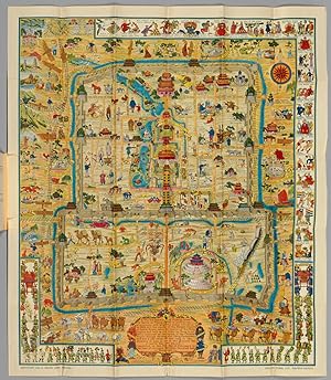
A Map and History of Peiping. Formerly known as Peking; capital of provinces princedoms, and kingdoms since 1121 B.C.; in 1264 A.D. the capital of the Mongol Empire of Kublai Khan; made the capital of the Ming Empire and built as it is today by Yung Lo in 1421; continued as the capital of the Chinese Empire through the Ming and Ch'ing Dynasties; and now a city which will live long in the memory of man as one of the greatest the world has ever known. Completed of this fifth day of February in the year of our Lord Nineteen Hundred and Thirty-six.With Explanatory booklet. By Frank Dorn, Peiping.
Published by Lithographed & Published by The Peiyang Press, Ltd., Tientsin-Peiping, 1936., 1936
Seller: Librairie Camille Sourget, Paris, France
Association Member: ILAB
Seller rating 4 out of 5 stars
Couverture rigide. Condition: Tr�s bon. Normal 0 21 false false false FR X-NONE X-NONE /* Style Definitions */ table.MsoNormalTable {mso-style-name:"Tableau Normal"; mso-tstyle-rowband-size:0; mso-tstyle-colband-size:0; mso-style-noshow:yes; mso-style-priority:99; mso-style-parent:""; mso-padding-alt:0cm 5.4pt 0cm 5.4pt; mso-para-margin:0cm; mso-para-margin-bottom:.0001pt; line-height:115%; mso-pagination:widow-orphan; font-size:11.0pt; font-family:"Times New Roman","serif"; mso-fareast-language:EN-US;} Very rare first edition, complete with the folded map and the booklet, preserved in the publisher's illustrated folder. Finely executed pictorial map of Beijing, published by Frank Dorn and the Peiyang Press. Ltd. of Tientsin and Peiping, in 1936. Dorn's map is perhaps the best known and most iconic pictorial map of Beijing published in the 20th Century, offering a host of interesting ethnographic and iconographic information about Beijing and its environs, while retaining the whimsical qualities of the great pictorial maps of the first half the 20th Century. Dorn's map is considered one of the great maps of the golden era of pictorial mapmaking. The map is ringed with a series of cartoon vignettes illustrating the history of the city from ancient times to 1936. Dorn was a friend and admirer of the pictorial mapmaker Jo Mora (1876-1847), and was clearly influenced by Mora's style of combining accurate pictorial details, bright colors and a bit of whimsy, along with vignettes providing an illustrated history of the place. The cartouche is decorated with names and dates of historical events and this legend in the center. Frank Dorn was an artist, writer and military officer. Growing up in San Francisco, he attended the San Francisco Art Institute and became an accomplished cartoonist. After graduation from West Point, he was assigned a post in the Philippines, and as a side project wrote a book about a clan of tribal people he got to know there. An acquaintance of California artist Jo Mora, Dorn began making his own maps; an early one depicted Camp Strassenbourg in the Philippines. While living in China, Dorn made his popular pictorial map of "Peiping". He later served in the field as advisor to a Chinese army. A fluent speaker of Chinese, Dorn's most important military role was in the China-Burma-India theater during World War II. There he served with Deputy Chief of Staff of the U.S. Army forces, General "Uncle Joe" Stilwell, during the Burma campaign from 1942 to 1944, and served as a commanding officer in 1944-45. A 1942 Life Magazine article about the Burma mission stated that, "Dorn, an artist, drew Stilwell's campaign maps." Dorn eventually attained the rank of Brigadier-General and retired in 1953. He settled in Carmel, California, living what his friend John Thompson describes as "a semi-bohemian life, writing and painting. In the Sixties he did some amazing psychedelic paintings, wondered if he was the incarnation of a Buddhist painter, and held progressive civil rights and antiwar views." In the 1970s, Dorn authored two highly-regarded scholarly books on the Chinese and Burmese theaters of World War II. A fascinating pictorial map of Beijing, drawn by an American officer who was a military attach� in China during the 1930s. It features vignettes of Chinese history from 1100 BC to 1927 as well as modern tourist attractions including golf and race courses. Hints to the political situation include the 'Kuomintang Headquarters'; and the German swastika and the Japanese 'Rising Sun' flags flying in the 'Legation Quarter', the year before the official start of the Second Sino-Japanese War in 1937. Frank Dorn (1901-81) was a graduate of West Point (where he picked up the life-long nickname of 'Pinky'), before being posted to Beijing in 1934 to help gather intelligence on Japanese aggression. He immersed himself in the language and culture of the city, researching the Forbidden City and collecting antiquities. When war with Japan broke out Dorn became chief-of-staff.
-
Hardcover. Condition: Near Fine. Dust Jacket Condition: No DJ as Issued. Frank Dorn (illustrator). 1st Edition 1st Issue. This is the original chromo lithographi map of Peking and the History of China in English and some Chinese issued in the capital of China in 1936 ORIGINAL MAP AND HISTORY OF PEIPING. THE MAP WAS DONE BY FRANK DORN. IT IS A PICTORIAL MAP WITH ANCIENT HISTORY OF PEKING WHICH ARE IN AMAZING CONDITION WITH ONLY VERY LIGHT WEAR. THE MAP MEASURES ABOUT 34 1/4" BY 29 3/4". Light wear loose without the cover album and not folded, comes in a full heavy duty mylar sleeve, and can be custom framed under Plexiglass with a museum frame if you choose. very rare, could only find one and it was on ebay for 2500 dollars no tears just the usual wearRetired Army Brig. Gen. Frank Dorn, 80, a soldier, a linguist, an author, a painter and a noted cook, died of cancer Sunday at Walter Reed Army Medical Center. Gen. Dorn was born in San Francisco and studied at the San Francisco Institute of Art. He then went to the U.S. Military Academy at West Point, where he graduated in 1923 and was commissioned in the field artillery. For the next 30 years, his profession was soldiering. In the course of it, he saw some of the most difficult campaigning in World War II and came into contact with some of the most formidable personalities of his time. In 1937, he was an assistant military attache in Peking when the Sino-Japanese war broke out. The senior attache at the time was Joseph W. (Vinegar Joe) Stilwell, then a colonel. Gen. Dorn, who was fluent in Chinese, observed the war between China and Japan from both sides, on one occasion walking across the "no-man's land" dividing opposing forces. General Frank Dorn retired from the Army in 1953, he attended the San Francisco Academy of Fine Art and attained high levels of skilll as a cartoonist and artist, his classic map of Peking was a labor of love.
-
paperback. Condition: Good. Ship out in 2 business day, And Fast shipping, Free Tracking number will be provided after the shipment.Revolution of modern Peking Opera Shajiabang revised in May 1970 (before 16 multi-map) Quotations from Chairman Mao 1 September 1970 India! SACFour Satisfaction guaranteed,or money back.


![Seller image for Guide to Peking and its Environs Near and Far (2nd ed.1924, with the large colour folding map, 'Plan of Peking Inside its Walls') for sale by Muir Books [Robert Muir Old & Rare Books]](https://pictures.abebooks.com/inventory/md/md31226415448.jpg)