Nagasaki Map (15 results)
 More images
Published by Reclus
- Art Print
Seller: Artisans-lane Maps & Prints, Sidney, BC, CanadaArtisans-lane Maps & Prints
Contact seller4-star sellerCondition: Used - Very good
US$ 14.53
US$ 19.00 shippingShips from Canada to U.S.A.Quantity: 1 available
no binding. Condition: very good. Mount Unzen, also known as Unzen-san, is an active volcano located in Nagasaki Prefecture, Kyushu, Japan. It is part of the larger Unzen volcanic complex, which includes several peaks and volcanic features. Image Size: 4 1/4 x 3 ins. Overall Size including text and borders : 10 1/2 x 7 Ins . CON…DITION: Intext map with text on the back. Clear and sharp with beautiful detail. As scanned. This beautiful print would look great matted and framed. Or an art supply store can provide you with a selection of frames for old art treasures. NOTE THE FOLLOWING BEFORE YOU PURCHASE: This is a GENUINE ANTIQUE VINTAGE 1880s PRINT. It is NOT a modern reproduction, ie. a laser scan, photocopy etc. It is the original from the antique or vintage atlas or book publication. This print was published on the date mentioned, or circa of the date mentioned at the top of the page. The print I have for sale, like many antique vintage prints and maps that you see online, originate from an antique vintage book or atlas publication. The publication may not always be known. If you have any questions, emails are welcome.
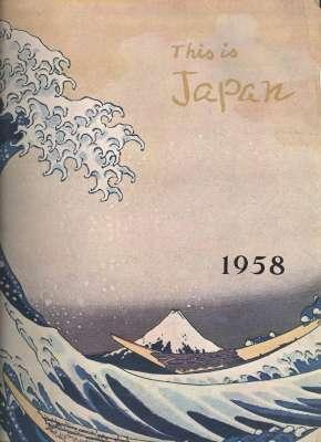
Published by Tokyo : Asahi Shimbun Newspaper Pub. Co., Toppan Printing Co., 1958 1958
- Hardcover
Seller: Joseph Valles - Books, Stockbridge, GA, U.S.A.Joseph Valles - Books
Contact seller5-star sellerCondition: Used - Fair
US$ 55.00
US$ 16.95 shippingShips within U.S.A.Quantity: 1 available
Hardcover. Condition: Fair. 388 pp. : illustrated , portraits ; 33 cm. ; Folio ; Dewey: 915.2 ; OCLC: 25975538 ; stiff color pictorial paper wrappers with image of Hokusai Katsushika's Kanagawa-oki Namiura (Raging Billows off Kanagawa) ; articles by Fujita, Takeo, 1905-, Eric Britter, Tiltman, H. Hessell b. 1897, Richard Hughes,… Shinjiro Tananka, Ernest Silver, Ito, Noboru, 1908-, Yoshida, Shigeru, 1878-1967 (?? ?)., Dreyfuss, Henry, 1904-1972, Guillain, Robert, 1908-, Yoshida, Kenichi, 1912-1977. (????), Glenn W. Sha w, Ilya Erenberg, Sakanishi, Shio,; 1899-, Pakenham, Thomas Compton, , Yuki, Ko, 1896-, Sawada, Miki, 1901-1980., Guro Kamiguchi, Yasusaburo Watanabe, Sano, Shigejiro, 1900-1987, Elizabeth B. Williams, Matha Nett, Donovan, Maria Kozslik, Samuel Bosw ell, Leon Picon, Yanagita, Kunio, 1875-1962 (?? ?? ), Kojima, Masajiro,; 1894-1994 (????? ) , Desmon Robins, Raymond, Antonin, 1888-, Fujioka, Michio, 1908-1988, Nakaya, Ukichiro, 1900-1962 (?? ???), Peter Robinson, Kawakami, Sumio, 1895-1972., John Campbell, Takamura, Kotaro, 1883-1956.(?? ??? ), Shingo Yamaji, Bunsho Jugaku, Suzuki, Shintaro,; 1895-1970. . Saito, Torao,; 1902-1971. , John T. Ishizaki, Takemura, Shosuke, 1943-, Shunji Shirazaki, Richard Hughes, Gwynneth Hawley, W P Fegan, Tais uke Kitamura, Hideji Yamazaki, Shigejiro Sano, Saito, Kiyoshi, 1907-1997 ((?? ), Takesuke Yamakawa, Masaru Fujibayashi, Fukutaro Yamazaki, Toshiro Miya, Kennosuke Takeda, Takashi Koike, Sugiura, Kohei,; 1932- , Kinji Inoue, Soyozo Watanabe, Tadao U jihara, Masao Kawauchi, Yasuro Urugawa, Ogura, Haruo,; 1928- , Ko Toda, Minako Usuki, Peter Robinson, George Y Somekawa, Bester, John, 1927- , Taizen Suzuki, Shigetaka Munetomo, and Shingo Yamaji ; Contents: Asahi's part in the Antarctic Expedition Chronicle 1956-57 -- Letters to the Editor -- The Influences of 'Southern Barbarian' Art in Japan -- Japan travel Bureau Expands Services -- Iron and Steel : A Success Story / Takeo Fujita -- Japan Makes Her Voice Heard / Eric Britter -- Japan's Dem ocratic Era / Hessell Tillman -- Honourable Bridge / RIchard Hughes -- Japan Discovers the Atom / Shinjiro Tanaka -- Japanese Fly Again / Ernest Silver -- 'New Education' Suffers Growing Pains / Noburo Ito -- Random Thoughts / Shigeru Yoshida -- Nor th and South -- 'The Word, I Think, is Shibui."/ Henry Dreyfuss -- Sorry, Kipling-san, The Twain DO Meet / Robert Guillan -- Japanese Culture?--What a Laugh! / Kenichi Yoshida -- Half a Lifetime in Japan / Glenn W Shaw -- Through a Soviet Writer's Eyes / Ilya Erenburg -- Japan : A Selected Bibliography / Shio Sakanishi -- A Walk with History / Compton Pakenham -- Korin Ogata -- Okyo Maruyama -- Christianity in Japan, Today and Yesterday / Ko Yuki, Mike Sawada -- The Forgotten Face of TIme / Guro Kamiguchi -- Time and the Animal World / Yasusaburo Tsukada -- Campfire in the Living Room / Shinichiro Watanabe -- Behind the Kabuki Curtain -- The Gentle Art of Sitting on the Floor / Shohachi Kimura -- Kimono Miscellany / Shigejiro Sano -- C hallenge to Silk Artists / Elizabeth B Willis -- Mud Makes a Luxury Fabric -- American Girl Finds Japan / Martha Nett -- Tristan Isolde and Sukiyaki / Maria Donovan -- Go North, Young Man! / Samuel Boswell -- A Guide to Sake-Drinkers / Leon Picon -- Rice : Mirror of Japanese History / Kunio Yanagida -- The Lunch-box Gourmet / Masajiro Kojima -- Folk-houses : North and South -- Self-Defence in Japan : The Throw, The Blow, Thw Know / Desmon Robins -- Religious architecture in Japan / Antonin Ray mond -- Modern Buddhist Temples / Michio Fujioka -- American 'Frontier' pioneering in Old Hokkaido / Ukichiro Nakaya -- The Quiet People / Peter Robinson -- Picture Map of Hokkaido / Sumio Kawakami -- Japan's Other Island / John Campbell -- My Life in the Mountains / Kotaro Takamura -- Picture Map of Hokkaido / Shingo Yamaji -- Iron and Inividualism -- From Bark to Paper / Bunsho Jugaku -- Japan's Ports - Past and Present -- The Shippoku Cooking of Nagsaki - Clay and Originality, etc; FAIR. Book.

Published by Chikuma Shobo 1976
- Softcover
Seller: Sunny Day Bookstore, SINGAPORE, , SingaporeSunny Day Bookstore
Contact seller4-star sellerCondition: Used - Fine
US$ 60.00
US$ 15.00 shippingShips from Singapore to U.S.A.Quantity: 1 available
Condition: Fine. Number of pages: 175. 8p (shared) Size: 30cm.
 More images
Language: English
Published by Tokyo: Sosuke Ono, 1885., Tokyo: 1885
- Map
Seller: BOSPHORUS BOOKS, Istanbul, , TurkeyBOSPHORUS BOOKS
Contact seller4-star sellerCondition: Used - Very good
US$ 885.45
US$ 40.12 shippingShips from Turkey to U.S.A.Quantity: 1 available
No Binding. Condition: Very Good. [MAP OF NAGASAKI] [Map of Nagasaki]. Published by Sosuke Ono. Printing date: July 14, 1885. Tokyo: Sosuke Ono, 1885. Hand colored map. 85x50 cm. Very good ISBN: CATALOG: Maps & Engravings KEYWORDS: Map Geography Topography Harbour Japan.

Seller: Hakone Books, Fujisawa, KANAG, JapanHakone Books
Contact seller5-star sellerCondition: Used
US$ 61.84
US$ 9.99 shippingShips from Japan to U.S.A.Quantity: 3 available
This set from Uniplanning includes a guide for walking and sightseeing in Nagasaki City, along with a large-format map of Nagasaki. It is designed to help you explore and appreciate the city's attractions. Perfect for tourists and locals alike, this guide will help you navigate Nagasaki with ease. Note: The text is entirely in J…apanese. Brand New Japanese Edition. Ships worldwide from Japan via Japan Post. Expedited shipping via FedEx available.
- Softcover
Seller: Vasco & Co / Emilia da Paz, Brussels, , BelgiumVasco & Co / Emilia da Paz
Contact seller5-star sellerCondition: Used - Fine
US$ 70.84
US$ 48.14 shippingShips from Belgium to U.S.A.Quantity: 1 available
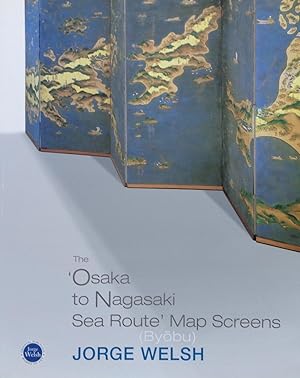
Soft cover. Condition: Fine. Byobu Published by Jorge Welsh Books 2007 41 pp edited by Luisa Vinhais and Jorge Welsh Photography by P. J. Gates all ill. in colour.
 More images
- Softcover
- Map
Seller: RareMapsandBooks, Dover, NH, U.S.A.RareMapsandBooks
Contact seller4-star sellerCondition: Used - Good
US$ 112.50
US$ 6.95 shippingShips within U.S.A.Quantity: 1 available
Condition: good. (Old Maps, 20th Century Maps, Asia, Japan, Nagasaki Prefecture, Folding Maps, Travel, Tourism). Nagasaki, Japan. Published July 15th, 1952, Osaka Japan by Warakujiya. Folding color map. Text completely in Japanese, intended for the local market. Publisher's pictorial paper wrappers folded into panels. Affixed to… the rear inside cover is what appears to be the final leaf of an index booklet no longer present. Item is old and shows some signs of handling and time. Item is not new or in "new" condition. Paper gently age worn, slight rubbing, remains overall clean and attractive as a fragile survival. Paper is lightly toned, signs of handling, small scattered spotting, internally still well preserved, tight, sound. Still attractive on the shelf. The scarce pamphlet displays a pleasing and unique age patina and is in nice antiquarian condition, any age flaws easy to overlook or forgive. Please review photos for more detail and our best attempt to convey how this item survives. Covers measures c. 7 1/2" H x 4 3/4" W.[B6494].

Seller: RARE ORIENTAL BOOK CO., ABAA, ILAB, Aptos, CA, U.S.A.RARE ORIENTAL BOOK CO., ABAA, ILAB
Contact seller5-star sellerParis [1898], Service Geographique de l'Armee. Colored map, linen backed cloth, very clean, bright, no defects, 60 x 51 cm., 3 folds, folds down to 19.7 x 25.5 cm., in the best of condition. FIRST & ONLY RARE EDITION Published by Dessine for the Geographical Service of the French Army [Service Geographique de lArmee], French tex…t. . * This map shows 32 degrees south by 36 degrees north and 126 degrees east by 132 degrees east. Showing the tip of South Korea at the upper left, Ke-dji, port of Fousan, Qul-san, Tai-kou, Tsushima & Iki Islands, Fouokae Shima [Fukue Jima], Hirado Island, all of the upper part of Kyushu, Shimonoseki [Modji], lower part of Honshu & Shikoku, the inland sea, Yamaguchi, up to Okayama, Takamatsu, Kochi and down to coast to Imano. Avery good look at southern Japan. . *** The map includes topographical details, roads & railroads in red, rivers, towns, provinces, bays, islands, harbors, soundings, etc. . *** NOTE: See us for other maps in this series: two Korean maps: QUELPAERT & KANG-NEUNG. Five maps of north-eastern China: VLADIVOSTOK, MOUKDEN, TCHENG-TE FOU, PEKIN & NANKIN, sold as only as a set of five maps. . *** REFERERNCES: . The maps are discussed at length in the journal of the Eighth Annual Geographical Conference, in an article written in French. The article state that the information utilized is derived primarily from a Russian map, with additions provided by Missionaries and the French Military Attache in Beijing. . NOTE: We have not verified this reference but believe it does relate to these and other maps listed below, issued by the French army, See our other listings under author: Service Geographique de Larmee. . *** Journal of the Royal Geographical Society, Volume 15 [1900]: the following entry appears for this map: Asie. Scale 1: 1,000,000 or 15'8 stat. miles to an inch. . ***.

Published by French Army Map 1904
- First Edition
- Map
Seller: Tmecca Inc., Seoul, , Korea, Republic ofTmecca Inc.
Contact seller2-star sellerCondition: Used - As new
US$ 500.00
US$ 19.99 shippingShips from Korea, Republic of to U.S.A.Quantity: 1 available
No Binding. Condition: As New. 1st Edition. 67 x 54cm.

- Map
Seller: Geographicus Rare Antique Maps, Brooklyn, NY, U.S.A.Geographicus Rare Antique Maps
Contact seller4-star sellerVery good. Two sheets, joined by publisher. Small spots of soiling in margins. Folds into original covers. Size 19 x 27 Inches. A colorful c. 1860 ukiyo-e woodblock map of Nagasaki, published by Baik?d? It displays the port city in the wake of its opening to foreign trade as a treaty port, superseding its earlier role as Japan's… outlet to the world via exclusive trade with Chinese and Dutch merchants. A Closer Look Oriented towards the northwest, this map covers both shores of Nagasaki Bay, recording streets, bridges, temples, shrines, agricultural fields (?), mountains, and other features. Both Japanese and foreign ships appear in the bay, some of the latter being steamships. Dejima (??), an artificial island near center, was Japan's only open port to the Western world for most of the Tokugawa period (1600 - 1868); the Dutch were granted exclusive trading rights and Dejima retains a Dutch flag atop a tall flagpole here. To the south of Dejima is the T?jinyashiki (????), a similar quarter reserved for Chinese merchants, as well as an area marked T?jinyashiki 'New Area' (Shinchi ??), which developed into Nagasaki's Chinatown. The area southwest of Dejima is where foreign warehouses were set up in the months preceding this map's publication. Foreign flags, warehouses, and even some churches can be seen here. Today, the area is home to a museum and gardens named Glover Gardens, after Thomas Blake Glover (1838 - 1912), a British merchant who played a prominent role among the foreign community in Nagasaki at the time. At the bottom and bottom-left are tables of distances between different points in Nagasaki, and between Nagasaki and major Japanese cities and ports, as well as a brief description of the port's history as an outlet for trade with Chinese and Dutch merchants. Opening the Window a Little More From the 1630s until the 1850s, the Tokugawa Shogunate pursued sakoku ('locked country') policies, restricting foreign trade to Chinese and Dutch merchants at Nagasaki. The shogunate was particularly concerned about the potential spread of Christianity, which in the 16th - 17th centuries had gained a foothold in southern Japan, where the Tokugawa were relatively weak. But after Japan's forcible opening at the hands of the Americans in the 1850s, culminating in the 1858 Treaty of Amity and Commerce (also known as the Harris Treaty), Nagasaki was one of five ports opened to foreign trade in 1859. In the following years, foreign merchants from multiple nations joined the Dutch and Japanese in Nagasaki, and the city became an even more important conduit for foreign ideas and knowledge. As the Tokugawa had feared all along, southern daimyo, especially from nearby Ch?sh? and Satsuma Domains, used these foreign connections to plot the downfall of the shogunate, which they achieved in 1868. Publication History and Census A map with this title and format was printed as early as 1802 by K?jud? (???), which is credited here. The present map was an enlarged reprint of the original by Baik?d? (???), with added features such as the foreign ships and warehouses mentioned above, which also help date it to c. 1860. A map of this title dated c. 1860 is noted among the holdings of the Library of Congress and the University of California Berkeley in the OCLC, though the example held by UC Berkeley has a slightly different format, with an additional, smaller sheet appended to those seen here, covering some of the islands southwest of Nagasaki. The University of British Columbia and Waseda University also hold examples matching the present one, which are not listed in the OCLC. References: OCLC 166424307. University of British Columbia Library, Rare Books and Special Collections. G7964.N26 P55 1800z B2. Waseda University Library Special Collections, Call No. ??08 C0347.
 More images
Seller: RARE ORIENTAL BOOK CO., ABAA, ILAB, Aptos, CA, U.S.A.RARE ORIENTAL BOOK CO., ABAA, ILAB
Contact seller5-star sellerNagasaki ca.[1802], Kojudo. Blue decorated printed covers, on yellow paper, 2 red Hanko [seals], sheet size: 68.9 x 47 cm., map size: 64.3 x 45.9 cm., very clean solid and crisp copy, color woodblock printed, an excellent example. R A R E . *** *** *** . . . AN EARLY WOODBLOCK COLOR MAP OF NAGASAKI . . . A "NEWLY CARVED" MAP OF…NAGASAKI BAY & DESHIMA . . . DUTCH & CHINESE SHIPPING . * THE MAP: This map shows "SHIN SEN" ["NEWLY CARVED WOODBLOCK"] of Nagasaki Bay and environs, with special attention to Deshima & Chinese Islands where the Dutch and Chinese lived isolated and restricted from the mainland. It also shows the details of Nagasaki city, a lively foreign trading port. . The map clearly illustrates the two most important islands of Deshima and the Chinese. Each island had a bridge connecting it to the mainland, which was guarded by Tokugawa Samurai. Foreigners were forbidden by Japanese law from entering the mainland. . Products such as water & food were brought to the islands, as well as a good number of Japanese prostitutes, all sanctioned by the Shogun. . The Dutch Factory manager was granted audience with the Shogun in Edo once a year. This annual event was to pay homage to the Shogun. . The procession was conducted by the Samurai, as the group walked a very long distance to Edo. In Edo the Dutch representative paid his respects to the Shogun who sat behind a screen. The Dutchman was instructed to speak, dance, walk and perform. . There is a stunning and famous primary account of this by Dr. Engelbert Kaempfer published in 1827, please inquire with us as we have a copy in stock. . The harbor shows two large Dutch sailing vessel under full sail, with the Dutch and several other flags flying in the breeze. A large sea-going Chinese junk in full sail, most likely preparing to get under way. There are also two large Japanese junks moored at the shore line. There are numerous other smaller Japanese junk type vessels in the harbor. . At the corners are four Kanji [Chinese characters used by Japanese] noting North, South, East and West. With two cartouches inset at the lower left. The first showing a distant chart from Nagasaki to foreign countries. The second gives the distance from Nagasaki to other port cities in Japan. All distances are cited in Japanese Rim [miles]. At the extreme left of the cartouche is the Japanese colophon. . The map meticulously shows villages, various sights, shrine & temples, the quay, streets, harbors, beaches, rivers, important Japanese trading houses located on the mainland across from near the Dutch & Chinese residences. Other large Japanese trading company are shown, each street and block is named are labeled. . An historically important, a very decorative map. Earlier maps of Nagasaki are always difficult to find. All in all, a very nice clean example of an early 19th century map of the whole area. . In the colophon it states [we translate]: "Nagasaki is beautiful, flourishing city in a 4 km. square, with mountains in the East, South, North, with a good and large port in the West. There are many Dutch & Chinese merchants." . *** WOODBLOCK PRINTING: This work was printed on two large Deluxe size sheets of Washi [hand-made] paper, joined at the center. This map was printed on extraordinary large size cherry wood blocks, all of which was an expensive and extravagant production. The average woodblock print of the time was printed on a standard sheet ca. 23 x 36 cm. . The map was printed in polychrome: pastel shades of blue, yellow, green with black 'key' block outline. . *** DATING: The map as usual is undated, printed in Nagasaki. . It is certain the First Edition of this map was printed in Kyowa 2nd year [1801], illustrated in Nagayama [see below] as Nagasaki map no. 147. Our map herein offered is identical to Nagayama's with one exception. In the colophon at the lower left corner, the last box at the left shows a different publisher and their details. . SECOND EDITION: Our map is clearly th.

Seller: Bartele Gallery - The Netherlands, Langweer, FRL, NetherlandsBartele Gallery - The Netherlands
Contact seller5-star sellerCondition: Used
US$ 212.51
US$ 19.49 shippingShips from Netherlands to U.S.A.Quantity: 1 available
Antique map of Japan titled 'Japan - Environs of Tokio & Nagasaki'. Old map of Japan, includes inset maps of Tokyo, Nagasaki and surroundings. This map originates from 'The Times' atlas. Artists and Engravers: John George Bartholomew (22 March 1860 ? 14 April 1920) was a British cartographer and geographer. As a holder of a roya…l warrant, he used the title "Cartographer to the King"; for this reason he was sometimes known by the epithet "the Prince of Cartography". Bartholomew's longest lasting legacy is arguably naming the continent of Antarctica, which until his use of the term in 1890 had been largely ignored due to its lack of resources and harsh climate. Condition: Very good, please study image carefully. Date: 1922 Overall size: 45 x 59 cm. Image size: 41.5 x 54 cm. We sell original antique maps to collectors, historians, educators and interior decorators all over the world. Our collection includes a wide range of authentic antique maps from the 16th to the 20th centuries. Buying and collecting antique maps is a tradition that goes back hundreds of years. Antique maps have proved a richly rewarding investment over the past decade, thanks to a growing appreciation of their unique historical appeal. Today the decorative qualities of antique maps are widely recognized by interior designers who appreciate their beauty and design flexibility. Depending on the individual map, presentation, and context, a rare or antique map can be modern, traditional, abstract, figurative, serious or whimsical.

- Map
Seller: Antique Paper Company, ASHFORD, KENT, United KingdomAntique Paper Company
Contact seller2-star sellerCondition: Used - Fine
US$ 306.07
US$ 7.92 shippingShips from United Kingdom to U.S.A.Quantity: 1 available
No Binding. Condition: Fine. No Jacket. 1864- JAPAN MANDSHURIA (Showing the course of the Amur River) THE KURILE ISLESA fine decorative original antique map with inset map of PORT OF NAGASAKI with vignettes JAPANESE NOBLEMAN FISHERMAN, PORT OF SIMONESEKE, JAPAN, JAPANESE WOMEN OF THE HIGHER LOWER CLASS.Published in The Royal Ill…ustrated Atlas of Modern Geography, by Archibald Fullarton Co.Overall size approx 31.5cm x 47cm including margins. Condition is generally fine with some expected light ageing around the margins. With original and later hand colourAntique Paper Company are a long established family business selling original antique prints, maps engravings as well as many other paper antiques such as original vintage Decorative Posters, Ephemera, Stamps Postal History, Manuscripts, Antiquarian Books much more. We are always looking to buy and have up to andpound;500,000 in immediate funds available. We are looking for exceptional single items, better collections, original archives, Atlases, Libraries, accumulations etc and have previously purchased from Major Institutions, Libraries, Collectors, Solicitors many other sources. We are happy to travel almost anywhere in the world for the right opportunities. So please do get in touch if you are considering selling your Antique Paper collectables. MAP.
 More images
Seller: Bartele Gallery - The Netherlands, Langweer, FRL, NetherlandsBartele Gallery - The Netherlands
Contact seller5-star sellerCondition: Used
US$ 543.07
US$ 19.49 shippingShips from Netherlands to U.S.A.Quantity: 1 available
Map of Nagasaki ? "Nangasacki appellé par les Chinois Tchangki", c.1760 This finely engraved 18th-century map depicts the Japanese port city of Nagasaki (Nangasacki), here noted as being called 'Tchangki' by the Chinese. Oriented with the coastline at the top, the map presents a fortified city nestled between mountainous terrain…, with the "Rivière de Nangasacki" flowing through its center. Small islands, including 'Mioxiema' and 'Paolata', appear offshore. A numbered key at the upper right identifies important landmarks, including: A. City of Nangasacki within its walls B. Fortress of the military governor C. Palace and smaller fortress of the governor D. Dutch lodge (*loge Hollandoise*) E. Large warehouse under the Chinese quartermaster's control F. Chinese lodge (*loge Chinoise*) G. Light boats for reconnaissance H. Places with cannon batteries J. Place for Dutch ships K. Place for Chinese ships A notable annotation on the map describes the "Grande montagne qui commande à la ville et sur laquelle on martyrisoit les Chrétiens" ? the large mountain overlooking the city where Christians were martyred, reflecting Japan's complex and often repressive relationship with Christianity during the Edo period. This engraving was executed by A. Porlier and is marked "Tome 9, No 1," indicating its position in a multi-volume Enlightenment-era work. Such maps were produced at a time when Japan was largely closed to foreign trade under the policy of 'sakoku', with Nagasaki as one of the very few ports open to limited international contact, primarily with the Dutch and Chinese. Collectors of Japanese history, cartography, and East Asian trade history will find this a valuable and visually engaging piece, capturing Nagasaki's unique position in the 18th-century global network. Condition: Very good for age, with central folds as issued. Minor toning and a few faint handling marks. Strong plate impression with fine detail in both topography and architectural depictions. Framing tips: A dark frame, such as ebony or black walnut, with a cream or light grey mount will draw out the delicate linework. For thematic displays, this map pairs beautifully with other 18th-century port city plans. Technique: Copperplate engraving Maker: A. Porlier sculp., French school, c.1760.
 More images
- First Edition
- Map
Seller: Far Eastern Booksellers / Kyokuto Shoten, Tokyo, , JapanFar Eastern Booksellers / Kyokuto Shoten
Contact seller4-star sellerCondition: Used - Very good
US$ 1,200.00
US$ 20.00 shippingShips from Japan to U.S.A.Quantity: 1 available
No Binding. Condition: Very Good. 1st Edition. First Edition. 8vo, original decorated wrappers.


