Plan Baltimore (62 results)

The Port Development Plan Of Baltimore, Md
Baltimore (md ) Port Development Com, Baltimore (md ) Port Development Com
- Softcover
Seller: GreatBookPrices, Columbia, MD, U.S.A.GreatBookPrices
Contact seller5-star sellerCondition: Used - As new
US$ 19.54
US$ 2.64 shippingShips within U.S.A.Quantity: Over 20 available
Condition: As New. Unread book in perfect condition.
The Port Development Plan Of Baltimore, Md
Baltimore (md ) Port Development Com, Baltimore (md ) Port Development Com
- Softcover
Seller: GreatBookPricesUK, Woodford Green, United KingdomGreatBookPricesUK
Contact seller5-star sellerCondition: Used - As new
US$ 22.11
US$ 19.80 shippingShips from United Kingdom to U.S.A.Quantity: Over 20 available
Condition: As New. Unread book in perfect condition.

Published by Karl Baedeker, Publisher 1909
- Map
Seller: Zephyrus Books, Wilmington, NY, U.S.A.Zephyrus Books
Contact seller5-star sellerCondition: Used - Very good
US$ 20.00
US$ 6.00 shippingShips within U.S.A.Quantity: 1 available
Map. Condition: Very Good. Original, vintage map from Baedeker's United States Travel Guide (1909). Intact and clean with some wear to edges. Map plate area itself is clean and free of flaws. Size is approximately 9.25 by 11 inches. Please see images.

Published by Municipal Art Society 1910
- Hardcover
Seller: THIS OLD BOOK, Brookfield, IL, U.S.A.THIS OLD BOOK
Contact seller5-star sellerCondition: Used - Very good
US$ 29.00
US$ 6.25 shippingShips within U.S.A.Quantity: 1 available
Hardcover. Condition: Used: Very Good. No Dust Jacket. This Original 1910 Printing (not a recent reprint) is clean, solid and in great shape! This is a hardcover book with 47 pages including some illustrations of city plans. The binding is strong with all pages firmly attached. There are a couple of library stamps on the pages b…ut otherwise clean inside. There is a name written on the first end paper. The title page shows 1910 as the only date. The blue covers are in good shape with some light edgewear and there is a quarter sized stain on the top of the front by the spine. We always ship in a sturdy cardboard box.
A Plan for Action on the Problems of Baltimore's Disadvantaged People
Human Renewal Program Steering Committee for a Plan for Action, Baltimore
Published by Health and Welfare Council of the Baltimore Area
Seller: Wonder Book, Frederick, MD, U.S.A.Wonder Book
Contact seller5-star sellerCondition: Fair. Acceptable condition. (Maryland, Baltimore, Poverty) A readable, intact copy that may have noticeable tears and wear to the spine. All pages of text are present, but they may include extensive notes and highlighting or be heavily stained. Includes reading copy only books. Bundled media such as CDs, DVDs, floppy…disks or access codes may not be included.

Published by Baltimore City Planning Commission, Baltimore 1976
- Softcover
- First Edition
Seller: Boards & Wraps, Baltimore, MD, U.S.A.Boards & Wraps
Contact seller4-star sellerCondition: Used - Very good
US$ 37.35
Free ShippingShips within U.S.A.Quantity: 1 available
Softcover. Condition: Very Good. First Edition. Light foxing, a few short tears and light bumps.; Details multi-service centers, economics, public safety facilities, libraries, solid waste disposal, waste water treatment, MetroCenter. ; Square 4to 9" - 11" tall.
Published by RTKL Inc.
- Softcover
Seller: Wonder Book, Frederick, MD, U.S.A.Wonder Book
Contact seller5-star sellerCondition: Good. Baltimore: RTKL Inc., n.d., ca. 1966. 8vo paperback. 72pp. B/W photos and limited color maps throughout. Near very good. Spine tips and joints lightly rubbed, and spine creased. Inside clean and bright. Inquire if you need further information.
Published by Försters artistische Anstalt Wien, 1841 1841
Seller: Antiquariat Bücherparadies, Landsberg, GermanyAntiquariat Bücherparadies
Contact seller4-star sellerCondition: Used
US$ 29.50
US$ 6.65 shippingShips from Germany to U.S.A.Quantity: 1 available
Mappe mit Zeichnungen guter Zustand 30 S.
 More images
Language: English
Published by City of Baltimore, Baltimore 1976
- Softcover
- First Edition
Seller: Bohemian Bookworm, Flemington, NJ, U.S.A.Bohemian Bookworm
Contact seller1-star sellerCondition: Used - Very good
US$ 72.39
US$ 4.00 shippingShips within U.S.A.Quantity: 1 available
Soft cover. Condition: Very Good. 1st Edition. Oversized square booklet, 55pps, rare glimpse into master plan and architectural aspects of urban American parks and accompanying zoos, concepts, photos, plans, solutions presented. VG but small amount of paper stuck to back paper cover.

Published by Baltimore County Office of Planning & Zoning, Towson, MD 1990
- Softcover
Seller: The Kelmscott Bookshop, ABAA, Savage, MD, U.S.A.The Kelmscott Bookshop, ABAA
Contact seller5-star sellerCondition: Used - Very good
US$ 45.00
US$ 8.00 shippingShips within U.S.A.Quantity: 1 available
Paperback. Condition: Very Good+. Paperback. Very good+ in oversize off-white illustrated paper wraps with green and black title to front wrapper. Minor yellowing and bumping to edges and light rubbing to wrappers. Pristine interior with illustrations throughout. Maryland. 149 pages. MAR12/4252.
Published by King Brothers, for the City of Baltimore 1881
- Softcover
- Signed
Seller: Tiber Books, Cockeysville, MD, U.S.A.Tiber Books
Contact seller4-star sellerCondition: Used - Good
US$ 50.00
US$ 5.49 shippingShips within U.S.A.Quantity: 1 available
Paperback. Condition: Good. . . . . 8vo, paperback. Presentation copy, SIGNED by the author, noted architect and civil engineer Charles H. Latrobe, on the front cover. Good condition. Missing rear cover. Front cover lightly soiled and worn; contents clean, no marking or writing. Binding sturdy and integral. 71 pp. Comprises a re…view of the history and literature of public municipal sanitation, and a summary of certain systems employed by other municipalities. Concludes with recommendations for Baltimore. Signed.

Language: English
Published by S. Augustus Mitchell 1882
- Map
Seller: Old Paper Old Ink, Murray, KY, U.S.A.Old Paper Old Ink
Contact seller4-star sellerCondition: Used - Near fine
US$ 59.95
US$ 5.22 shippingShips within U.S.A.Quantity: 1 available
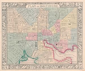
No Binding. Condition: Near Fine. S. Augustus Mitchell. Plan of Baltimore. 1882. *** An engraved lithograph map with original hand coloring. It depicts the street plan for Baltimore, Maryland as it was in the latter 19th. century, with railroads and railroad stations, canals, docks, and some of the important buildings. The entir…e map is surrounded by a decorative floral border. *** Clear, clean image with good colors. No folds, creases, or tears. Partial map printed on verso does not show through. *** Sheet is 11 inches high by 15.25 inches. Image is 9.25 inches high by 11 inches.
 More images
Language: English
Published by [W.M. Bradley & Bro.], [Philadelphia] 1886
Seller: Kaaterskill Books, ABAA/ILAB, East Jewett, NY, U.S.A.Kaaterskill Books, ABAA/ILAB
Contact seller5-star sellerCondition: Very good, faint toning. Hand colored map. Plate 45: Plan of Baltimore, Copyright by S. Augustus Mitchell, 1884. 11.25 x 9.5 inches. [On verso] Plates 46 & 47:County Map of the States of Delaware, Maryland, Virginia, and West Virginia, with two insets. Copyright by Wm. M. Bradley & Bro. 1884. 22.25 x 14.5 inches. [On…adjacent] Plate 48: Plan of the City of Washington, The Capitol of the United States of America, Copyright by S. Augustus Mitchell, 1884. Drawn & engraved by W.H. Gamble. 13.75 x 11.5 inches. From: Mitchell's New General Atlas, Containing Maps Of The Various Countries Of The World, Plans Of Cities, Etc., Embraced In Ninety-Three Quarto Maps, Forming A Series Of One Hundred and Forty-seven Maps and Plans, Together With Valuable Statistical Tables. Also, A List Of Post-Offices Of The United States And Territories, And Also Census Of 1880 For States, Territories And Counties, Also Of Cities Of Over 10,000 Inhabitants. Philadelphia: Published By Wm. M. Bradley & Bro., No. 1026 Arch Street. 1886.
 More images
Published by 0
- Softcover
Seller: Librairie du Levant, Bayonne, FranceLibrairie du Levant
Contact seller1-star sellerCondition: Used
US$ 53.11
US$ 6.87 shippingShips from France to U.S.A.Quantity: 1 available
Non daté : 2014 / 128 pages. Broché. Editions MGALLERY. Français Très bon état. RARE ET TRES GOURMAND .

- Softcover
Seller: Buchpark, Trebbin, , GermanyBuchpark
Contact seller5-star sellerCondition: Used - Fine
US$ 26.25
US$ 120.31 shippingShips from Germany to U.S.A.Quantity: 1 available
Condition: Sehr gut. Zustand: Sehr gut | Seiten: 348 | Sprache: Englisch | Produktart: Bücher | Keine Beschreibung verfügbar.
Published by District Court of the United States, Maryland 1938
- Hardcover
- First Edition
Seller: Vashon Island Books, Vashon, WA, U.S.A.Vashon Island Books
Contact seller5-star sellerCondition: Used - Very good
US$ 75.00
US$ 5.50 shippingShips within U.S.A.Quantity: 1 available
Hard Cover -. Condition: Very Good. No Dust Jacket. First Thus. In blue cloth with red leather spine label with gilt titling, 8vo, 677pp. (light shelfwear to extremities, name to endpapers). Size: 8vo - over 7¾" - 9¾". Book.

Published by Greenwich: Franklin X. McCormick 1954
- Art Print
Seller: Wittenborn Art Books, San Francisco, CA, U.S.A.Wittenborn Art Books
Contact seller5-star sellerCondition: Used - Good
US$ 50.00
US$ 10.00 shippingShips within U.S.A.Quantity: 1 available
Condition: Good. One leaf on enamel paper. 12 x 15 inches. Views and floor plan of the building. As published in "The Portfolio of Ecclesiastical Designs," Second Edition, 1954.Provenance: Clifford N Wright Architect, Birmingham, MI, with his stamp in the lower right margin.

Published by Mitchell S. Augustus, Philadelphia 1870
- Map
Seller: mediumraremaps.com, Franklin, TN, U.S.A.mediumraremaps.com
Contact seller4-star sellerCondition: Used - Very good
US$ 65.00
US$ 6.00 shippingShips within U.S.A.Quantity: 1 available
11 1/4 x 9 1/2 inches. Condition: Very Good. 1870 edition. Single page map with contemporary hand color. This plan of Baltimore show the town and its railroad network.
Published by Charles Center-Inner Harbor Mgt 1988
- Softcover
Seller: Southern Maryland Books, Waldorf, MD, U.S.A.Southern Maryland Books
Contact seller5-star sellerCondition: Used - Very good
US$ 99.99
US$ 4.99 shippingShips within U.S.A.Quantity: 1 available
Unknown Binding. Condition: Very Good. SPIRAL BOUND PAPERBACK - Little cover wear - clean unmarked text - tight binding. ** WE SHIP DAILY (Mon-Fri) ** Free Tracking Information.
 More images
- Map
Seller: RareMapsandBooks, Dover, NH, U.S.A.RareMapsandBooks
Contact seller4-star sellerCondition: Used - Good
US$ 37.50
US$ 6.95 shippingShips within U.S.A.Quantity: 1 available
Condition: good. Plan of Baltimore.(United States, Maryland, Baltimore, City Plan, Patapsco River, Mc Clare Station, Green Mountain Cemetery). Issued c. 1872, Philadelphia by S. A. Mitchell. Fine 19th century engraved (lithographed) map, with original hand color. Mitchell maps of this mid-century era were issued with a range of…variant decorative borders. Attractive example, pleasing age patina, overall clean, any minor age flaws easy to overlook or forgive. Sheet Measures c. 15 1/4" H x 12 1/2" W. Engraved Area Measures c. 13 3/4" H x 11 1/4" W. Cartographic Reference (s):Reps, American Maps and Mapmakers, p. 313. Tooley's Dictionary of Mapmakers, vol. 4, pp. 260.[R21789].
 More images
- Map
Seller: RareMapsandBooks, Dover, NH, U.S.A.RareMapsandBooks
Contact seller4-star sellerCondition: Used - Good
US$ 37.50
US$ 6.95 shippingShips within U.S.A.Quantity: 1 available
Condition: good. Plan of Baltimore.(North America, United States, Mid-Atlantic Region, Maryland, Baltimore, Patapsco River). Issued c. 1866, Philadelphia by S. A. Mitchell.19th century engraved map, with original hand color. Mitchell maps of this mid-century era were issued with a range of color as well as variant decorative bor…ders. Nice looking example, pleasing age patina, any minor age flaws easy to overlook or forgive. Sheet Measures c. 12 1/2" H x 15 1/4" W. Engraved Area Measures c. 10 1/2" H x 13 1/2" W. Cartographic Reference (s):Reps, American Maps and Mapmakers, p. 313. Tooley'sà Dictionary of Mapmakers, vol. 4, pp. 260.[R24405].
 More images
Seller: RareMapsandBooks, Dover, NH, U.S.A.RareMapsandBooks
Contact seller4-star sellerCondition: Used - Good
US$ 37.50
US$ 6.95 shippingShips within U.S.A.Quantity: 1 available
Condition: good. Plan of Baltimore.(Old Maps, 19th Century Maps, Americana, United States, Maryland, Baltimore, Patapsco River, City Plan). Issued 1882, Philadelphia by S. A. Mitchell. Fine 19th century engraved (lithographed) map, with original hand color. Mitchell maps of this mid-century era were issued with a range of varian…t decorative borders. Attractive example, pleasing age patina, overall clean, any minor age flaws easy to overlook or forgive. Sheet Measures c. 15 1/4" H x 12 1/2" W. Engraved Area Measures c. 13 3/4" H x 11 1/4" W. Cartographic Reference (s):Reps, American Maps and Mapmakers, p. 313. Tooley's Dictionary of Mapmakers, vol. 4, pp. 260.[R28636].
 More images
- Map
Seller: RareMapsandBooks, Dover, NH, U.S.A.RareMapsandBooks
Contact seller4-star sellerCondition: Used - Good
US$ 37.50
US$ 6.95 shippingShips within U.S.A.Quantity: 1 available
Condition: good. Baltimore.(Old Maps, 19th Century Maps, Americana, United States, Maryland, Baltimore, City Plan). Issued 1853, New York for Phelps & Fanning. Original mid- 19th century wax engraved (cerographic) gazetteer map with lovely hand color. Text on reverse as always, the only way to own this map. A superior visual exa…mple of a map rarely encountered with such pleasing hand color. Pleasing age patina, any age flaws minor and easy to overlook or forgive. Sheet Measures c. 9 1/4" H x 5 1/2" W. Engraved Area Measures c. 8" H x 4 3/4" W.[B13932].

Published by Mitchell, Samuel Augustus Jr., Philadelphia 1862
Seller: Argosy Book Store, ABAA, ILAB, New York, NY, U.S.A.Argosy Book Store, ABAA, ILAB
Contact seller5-star sellerunbound. Map. Engraving with original hand coloring. Image measures 9 1/2" x 11" This lovely city plan or town plan of Baltimore, MD depicts the city in beautiful detail. Shows streets, notable buildings, parks, railroads, and ferry and steamboat routes. The map is in very good condition. Full original margins, small chips and t…ears at edges. Samuel Augustus Mitchell Sr. (1792-1868) was one of the leaders in American cartography of the 19th century and pioneered the conversion of engraved map plates to more affordable lithographic plates. His son, Samuel Augustus Mitchell Jr. continued his father's successful mapmaking and publishing business, and was one of the most prolific and renowned 19th century American publishers.

Published by Mitchell, Samuel Augustus Jr., Philadelphia 1869
Seller: Argosy Book Store, ABAA, ILAB, New York, NY, U.S.A.Argosy Book Store, ABAA, ILAB
Contact seller5-star sellerunbound. Map. Engraving with original hand coloring. Image measures 9 1/2" x 11" This lovely city plan or town plan of Baltimore, MD depicts the city in beautiful detail. Shows streets, notable buildings, parks, railroads, and ferry and steamboat routes. The map is in very good condition. Full original margins, small chips and t…ears at edges. Samuel Augustus Mitchell Sr. (1792-1868) was one of the leaders in American cartography of the 19th century and pioneered the conversion of engraved map plates to more affordable lithographic plates. His son, Samuel Augustus Mitchell Jr. continued his father's successful mapmaking and publishing business, and was one of the most prolific and renowned 19th century American publishers.
Published by S. Augustus Mitchell, Jr., New York 1860
- Map
Seller: Main Street Fine Books & Mss, ABAA, Galena, IL, U.S.A.Main Street Fine Books & Mss, ABAA
Contact seller5-star sellerFolio (15¼" X 12¼", image area 11" X 9¼"). Hand colored. Very good. Light age toning, some minor soiling and small stain at lower right margin. Well colored example of this detailed city plan, from the 1864 edition of "Mitchell's New General Atlas, Containing Maps of the Various Countries of the World, Plans of Cities, Etc." Nic…e floral border and overall a charming rendition of "Charm City.".
Published by Baltimore, MD 1870
- Hardcover
- First Edition
Seller: Lux Mentis, Booksellers, ABAA/ILAB, Portland, ME, U.S.A.Lux Mentis, Booksellers, ABAA/ILAB
Contact seller5-star sellerCondition: Used - Very good
US$ 125.00
US$ 7.50 shippingShips within U.S.A.Quantity: 1 available
Condition: Very Good. First Edition. First Edition. A decorative floral boards surrounds this handcolored map of the districts of Baltimore. A handsome copy of a rather scarce plate. Light foxing, minor even toning, small closed tear at one edge, else bright and clean. 15.25"x12.25". Handcolored plate.
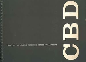
Published by CBD, Baltimore 1959
- Softcover
Seller: Studio Bibliografico Orfeo (ALAI - ILAB), Bologna, BO, ItalyStudio Bibliografico Orfeo (ALAI - ILAB)
Contact seller4-star sellerCondition: Used
US$ 59.01
US$ 74.48 shippingShips from Italy to U.S.A.Quantity: 1 available
28x35 cm, br. editoriale, dorso ad anelli, p. 135 numerose foto e piante Ottimo.
Published by Philadelphia 1864
Seller: Nicholas D. Riccio Rare Books, ABAA, Florham Park, NJ, U.S.A.Nicholas D. Riccio Rare Books, ABAA
Contact seller4-star sellerUnbound, colored engraved map, decorative border, 13" x 10 1/2". Slight toning and aging; otherwise very good. Maps are wrapped with acid free board, or in rigid sleeves. The Mitchell family started to produce atlases in 1846, and continued into the early 1890s. Around 1860, S. Augustus Mitchell Jr. took over, and the atlas woul…d be called Mitchell's New General Atlas. This is a detailed single page map of Boston from the 1864 installment of this atlas. The map ishows a lot of street detail. Ristow 311-313.
Published by Philadelphia: 1869
Seller: Nicholas D. Riccio Rare Books, ABAA, Florham Park, NJ, U.S.A.Nicholas D. Riccio Rare Books, ABAA
Contact seller4-star sellerUnbound, colored engraved map, decorative border, 14" x 11". Slight browning and aging; otherwise bright and clean and very good. Maps are wrapped with acid free board, or in rigid sleeves. The Mitchell family started to produce atlases in 1846, and continued into the early 1890s. Around 1860, S. Augustus Mitchell Jr. took over,… and the atlas would be called Mitchell's New General Atlas. This is a detailed single page map of Baltimore from the 1870 installment of this atlas. The map shows a lot of street detail with nice coloring. Extra postage may be required. Ristow 311-313. # 103226.


