Plan City Doway (7 results)
Published by London-47 1732
- Map
Seller: Robert Frew Ltd. ABA ILAB, London, , United KingdomRobert Frew Ltd. ABA ILAB
Contact seller5-star sellerCondition: Used
US$ 34.54
US$ 13.41 shippingShips from United Kingdom to U.S.A.Quantity: 1 available
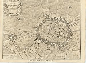
37 x 48 cm. Uncoloured. Double page plan. Lower margin shaved with slight loss to imprint, otherwise good.
Published by no date givenapproximately 1745, London 1745
- Map
Seller: Keoghs Books, Skipton, United KingdomKeoghs Books
Contact seller5-star sellerCondition: Used
US$ 35.92
US$ 37.56 shippingShips from United Kingdom to U.S.A.Quantity: 1 available
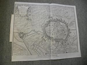
, 43 x 50 cm, engraved, folding map, originally a plate from a book, scale 700 feet to the inch, showing defences of Doway with decorative cartouche around title Second editon , a few small edge tears outside borders of map, creases from folding, map in very good condition engraved area 37 x 47 cm Map ISBN.
Published by For Mr Tindal 's continuation of Mr Rapin's history of England o J (um ) 1750
Seller: Ottmar Müller, Offenburg, , GermanyOttmar Müller
Contact seller2-star sellerCondition: Used
US$ 47.69
US$ 11.52 shippingShips from Germany to U.S.A.Quantity: 1 available
Größe ca. 50 x 40 cm. -Gefaltet, gebräunt, unterer Rand fl., Randeinrisse. 1000 gr.
Published by London-47 1743
- Map
Seller: Robert Frew Ltd. ABA ILAB, London, , United KingdomRobert Frew Ltd. ABA ILAB
Contact seller5-star sellerCondition: Used
US$ 69.08
US$ 13.41 shippingShips from United Kingdom to U.S.A.Quantity: 1 available
41 x 48 cm. Uncoloured. Double page plan. Left and right margins cropped at the feet. Generally very good.
 More images
- Map
Seller: RareMapsandBooks, Dover, NH, U.S.A.RareMapsandBooks
Contact seller4-star sellerCondition: Used - Good
US$ 42.50
US$ 6.95 shippingShips within U.S.A.Quantity: 1 available
Condition: good. Doway, A Strong City in the Earldom of Flanders in the Low Countries, Subject to the French.(Europe, France, Flanders, Douai) Issued ca. 1735-45, London. Engraved by J. Basire. Fine and uncommon old engraved city plan /battle map. Large cartouche at top left, north oriented downward towards lower left corner. In…teresting militaristic depiction of the city, showing the old fortified walls and star forts in great detail. The town was almost completely destroyed by the British during the War of Spanish Succession (1701-1713). Map depicts some troop positions during the siege of the city by British forces. Map remains well preserved. Some light age wear or surface spotting/ soiling which is visible within the scan, overall visually appealing Original fold line as issued. Sheet measures c. 117 3/8" H x 21 3/4" W. Printed area measures c. 14 1/2" H x 19 5/8" W Tooleys Dictionary of Mapmakers, v. 1, p. 95*[R20709].

PLAN OF THE CITY OF DOWAY - Original Antique Hand-Coloured Copper-engraved Plan
PLAN OF THE CITY OF DOWAY - Original Antique Hand-Coloured Copper-engraved Plan
Language: English
Seller: K Books Ltd ABA ILAB, York, YORKS, United KingdomK Books Ltd ABA ILAB
Contact seller5-star sellerCondition: Used - Very good
US$ 110.53
US$ 26.16 shippingShips from United Kingdom to U.S.A.Quantity: 1 available
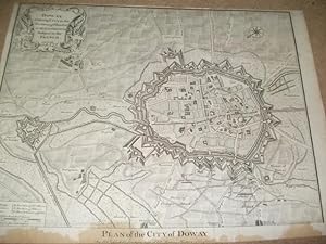
No Binding. Condition: Very Good. Hand-coloured Copper engraved plan, mounted (matted) and ready to frame in the UK, but for overseas customers it would probably be unmounted as it would be too large to post. Colouring not contemporary, but delicately and expertly done. No date, but printed c 1750. A Plan of the City of Doway, a… strong city in the Earldom of Flanders in the Low Countries, subject to the French. Printed for Mr Tindal's continuation of Mr Rapin's History of England. Basire (illustrator).

Published by [London]: 18th Century European Publisher, [1740s]. 1740
- Manuscript
Seller: Wittenborn Art Books, San Francisco, CA, U.S.A.Wittenborn Art Books
Contact seller5-star sellerCondition: Used - Good
US$ 100.00
US$ 10.00 shippingShips within U.S.A.Quantity: 1 available
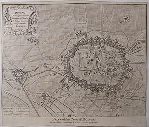
Condition: Good. 20 x 16 inches. Very Good. Appears to be trimmed at bottom edge and may have lost some text. Fine copperplate engraving. 18th Century, uncolored, folded map. Paul de Rapin's, The History of England by Nicholas Tindall. Douai France Old antique Plan of The City of Doway with fortification bastions and an overview… of the battlefield of the surroundings area.Paul de Rapin (25 March 1661 - 25 April 1725), sieur of Thoyras (and therefore styled Thoyras de Rapin), was a French historian writing under English patronage.


