Order Total (1 Item Items):
Shipping Destination:

Plat Maps, Used (54 results)
Skip to main search results
Search filters
Product Type
- All Product Types
- Books (47)
- Magazines & Periodicals (No further results match this refinement)
- Comics (No further results match this refinement)
- Sheet Music (No further results match this refinement)
- Art, Prints & Posters (No further results match this refinement)
- Photographs (No further results match this refinement)
- Maps (7)
- Manuscripts & Paper Collectibles (No further results match this refinement)
Condition Learn more
- New (No further results match this refinement)
- As New, Fine or Near Fine (8)
- Very Good or Good (40)
- Fair or Poor (2)
- As Described (4)
Binding
Collectible Attributes
- First Edition (3)
- Signed (2)
- Dust Jacket (No further results match this refinement)
- Seller-Supplied Images (30)
- Not Print on Demand (54)
Language (2)
Free Shipping
Seller Location
Seller Rating
-

Henry County Ohio Plat Book Index of Owners City Street Maps 1978 Edition
Published by Buckeye Plant Food INC, 1978
Seller: Library House Internet Sales, Grand Rapids, OH, U.S.A.
Seller rating 5 out of 5 stars

Pamphlet. Condition: Good. No Jacket. Buckeye Plant Food INC dark brown staining on cover Solid binding. Please note the image in this listing is a stock photo and may not match the covers of the actual item. Book.
-
Soft cover. Condition: Very Good. Five (5) land and plat maps of Jefferson County, Florida. The first one is 1993 plat directory published by Florida Plats. Next is 1982 plat directory published by Great Mid-Western Publishing Co., Inc. Next are two (2) 1976 land atlas plat maps pubished by Rocford Map Publishers, Inc. Last is a 1976 Leon County Land Atlas by J. Chris & George K. Floyd Associates, Inc.
-
Plat maps of Cerro Gordo County, Iowa : Updated to March 13, 2000.
Language: English
Published by Harlan, Iowa, 2000
Soft cover. Condition: Fine. 2000. 20 pages, 28 cm. A fine copy. Plat maps with ownership information for all of the county's townships.
-

Topography of the Battle of Plat A. the City of Plat a : The Field of Leuctra . With Maps and Plans.
Language: English
Published by British Library, Historical Print Editions, 2011
ISBN 10: 1241436711 ISBN 13: 9781241436711
Condition: As New. Unread book in perfect condition.
-
Maps of Illinois Counties in 1876, Together with the Plat of Chicago and Other Cities, and a Sampling of Illustrations, Reprinted from Illustrated Historical Atlas of the State of Illinois, Published by Union Atlas Co., Chicago, 1876
Language: English
Published by Mayhill Publications, 1972
Seller: Sequitur Books, Boonsboro, MD, U.S.A.
Association Member: IOBA
Seller rating 5 out of 5 stars
Paperback. Condition: Very Good. Softcover. Edge wear. Some spotting. This is an oversized or heavy book, which WILL require additional postage for Priority Mail or International delivery outside the US.
-
McClean County Illinois Plat Book Index of Owners City Street Maps 1977 Edition
Published by Town & Country Publishing Co., La Porte, IN, 1977
Seller: Book Stall of Rockford, Inc., Rockford, IL, U.S.A.
Association Member: MWABA
Seller rating 5 out of 5 stars
Soft Cover. Condition: Very Good. No Jacket. 1977 Edition. Light wear to the covers. Map pages are tight and essentially clean (a few individual farms may be marked). 72pp.
-
Plat Maps of Pocahontas County Iowa: Maps of Each townshiop in the County showing Farms, Owners, Acreages, Roads, Railroads, Streams, churches & Cemeteries
Published by R.C. Booth Enterprises, Harlan, Iowa, 2000
Soft cover. Condition: Very Good. 2000. 31 cm. 20 pages, followed by an eight page index of county residents by name. Some minor wear. Bookseller Inventory #.
-
MIAMI COUNTY INDIANA PLAT BOOK-INDEX OF OWNERS-CITY STREET MAPS-BICENTENNIAL EDITION
Published by Town & Country Publishing Co., La Porte IN, 1975
First Edition
Soft cover. Condition: Good. 1st Edition. 32pp; stapled. Township maps with ownership names. Contents clean; highlight mark on page 19. Light coffee-like stain to covers.
-
MAPS OF INDIANA COUNTIES IN 1876 Together with the Plat of Indianapolis and a Sampling of Illustrations
Language: English
Published by Indiana Historical Society, 1968
Seller: Sequitur Books, Boonsboro, MD, U.S.A.
Association Member: IOBA
Seller rating 5 out of 5 stars
Paperback. Condition: Fair. Softcover. Shelf wear. Tears to spine. Gutters weakened. Sold with all faults. This is an oversized or heavy book, which WILL require additional postage for Priority Mail or International delivery outside the US.
-
1985 plat maps of Madison County, Iowa : with township plats corrected to August 7,l 1984
Published by R.C. Booth Enterprises, Harlan, Iowa, 1985
Soft cover. Condition: Good. 10th Printing. (52 pages) : maps ; 34 cm. Some light wear and toning.
-
1990 plat maps of O'Brien County, Iowa : with township plats corrected to September 4, 1990
Published by R.C. Booth Enterprises, Harlan, Iowa, 1990
Soft cover. Condition: Fine. 1990. 1 atlas (18 pages) : all maps ; 32 cm. Plat maps by Township with ownership information, followed by an index of the County's rural residents, by name.
-

Topography of the Battle of Plat A. the City of Plat a : The Field of Leuctra . With Maps and Plans.
Language: English
Published by British Library, Historical Print Editions, 2011
ISBN 10: 1241436711 ISBN 13: 9781241436711
Seller: GreatBookPricesUK, Woodford Green, United Kingdom
Seller rating 5 out of 5 stars
US$ 25.04
US$ 20.22 shipping
Ships from United Kingdom to U.S.A.Quantity: Over 20 available
Add to basketCondition: As New. Unread book in perfect condition.
-
Michael D. Heaston Catalogue Forty-Three: Cartography of the American West - A Selection of Pocket, Plat, and Books and Pamphlets with Maps and Atlases
Published by Michael D. Heaston Rare Books & Manuscripts, Austin, Texas
Seller: Whiting Books, Fulshear, TX, U.S.A.
Seller rating 5 out of 5 stars
Soft cover. Condition: Fine. 218 items featured, some black and white images. A fine, unmarked copy.
-
Shelby County, Ohio, Official Plat Book 1989, Including Index of Owners, City Street Maps
Published by Town & Country Publications, La Porte, 1989
Stapled Soft Cover. Condition: Near Fine (faults). 48pp. Short marginal notes on two pages. Four small beverage spots on front cover.
-
Plat maps of Warren County, Iowa : with township plats corrected to July 7, 1992
Published by R.C. Booth Enterprises, Harlan, Iowa, 1992
Soft cover. Condition: Fine. 1992. 33 pages, 31 cm. In fine condition with a yellow still paper cover, stapled binding. Rare.
-
Washtenaw County Michigan Plat Maps 1856 and 1864: Reproduced from Wall Maps Published by Bechler & Wenig 1856 and Samuel Geil 1864
Published by Genealogical Society of Washtenaw County, Michigan, Inc., Ann Arbor, MI, 1997
Seller: The Dawn Treader Book Shop, Ann Arbor, MI, U.S.A.
Seller rating 4 out of 5 stars

Hardcover. Condition: Fine.
-
Maps of Illinois Counties in 1876 Together with the Plat of Chicago and other Cities .
Published by Mayhill Publications, Knightstown IN, 1972
Seller: Novel Ideas Books & Gifts, Decatur, IL, U.S.A.
Seller rating 4 out of 5 stars
Softcover. Condition: Good+. Reprint. Reprinted from the Illustrated Historical Atleas of the Stte of Illinois published by the Union Atlas Company in 1876. All black and white. Some curl near the spine. Light cover soiling. ; Folio 13" - 23" tall.
-
Maps of Illinois Counties in 1876, Together with the Plat of Chicago and Other Cities, and a Sampling of Illustrations, Reprinted from Illustrated Historical Atlas of the State of Illinois, Published by Union Atlas Co., Chicago, 1876
Published by Mayhill Publications, Knightstown, IN, 1972
Seller: Hyde Brothers, Booksellers, Fort Wayne, IN, U.S.A.
Seller rating 5 out of 5 stars
Softcover. Condition: Very Good+. Reprint Edition. Tan paper binding with black cloth backstrip very sl.ightly rubbed at corners; front cover & tp lightly bent at top corner; tp slightly foxed, else a very crisp, tight & clean atlas, with bright, clear map ils. ; In wraps; many great b&w map ils. ; Folio; Unpaginated pages.
-
Spiral bound. Condition: Very Good-. Plat and TAM maps for Pottawattamie County, IA in 2008-2009. Spiral bound soft cover published by R. C. Booth Enterprises in 2009. Light gray glossy cardstock covers with black lettering. Several maps have highlighting. An alphabetical locater of owners or renters is in back of book. Book is in very good minus condition. 4to, .7 lb.; 4to 11" - 13" tall.
-
Paperback. Condition: Good. Plat maps for Pottawattamie County, IA in 1992. Paperback, stapled binding, published by R. C. Booth Enterprises in 1992. Blue cardstock covers with black lettering. Front cover has a stamped name and address in upper corner and a written address in middle. Several maps have highlighting. One page has marks left from a paper clip at top. Book is in good condition. 4to, 35 pages, .3 lb.; 4to 11" - 13" tall; 35 pages.
-
MAPS OF ILLINOIS COUNTIES IN 1876 Together with the Plat of CHicago and Other Cities and a Sampling of Illustration
Published by Mayhil Publications, Knightstown, IN, 1972
Seller: Riverow Bookshop, Owego, NY, U.S.A.
Seller rating 5 out of 5 stars
Wraps. Condition: G/NO DUSTJACKET. Black & White Illustrations (illustrator). Reprint. Knightstown, IN: Mayhil Publications. G/NO DUSTJACKET. 1972. Reprint. Wraps. Reprinted from Illustrated Historical Atlas of the State of Illinois published by Union Atlas Company, Chiago . Atlas Folio, unpaginated, soiling, center page pulled & loose .
-
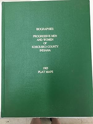
Progressive Men and Women of Kosciusko County, Indiana and 1903 Plat Maps
Language: English
Published by Light and Life Press, 1989
Hardcover. Condition: Very Good. Bound in bright green cloth with gilt titles, this is a reprint of the 1903 original, 641 pages plus 36 page name index. This is a hardcover copy and not the later cheaper paperback .Extra shipping charges mayapply due to weight of this heavy volume.
-
MAPS OF INDIANA COUNTIES IN 1876 Together with the Plat of Indianapolis and a Sampling of Illustrations
Published by Indiana Historical Society, 1968
Softcover. Condition: Very Good. Reprint. Very good and clean. Measures approx. 17 x 14 inches. ; Folio 13" - 23" tal.
-
Mecosta County, MI [Michigan] 2006 Land Atlas and Plat Book: featuring [city maps of] Barryton, Big Rapids, Mecosta, Morley, Remus, Stanwood
Published by [Cloud Cartographics, Inc.], 2006
Seller: Boyd Used & Rare Books, Portland, OR, U.S.A.
Association Member: CBA
Seller rating 5 out of 5 stars
Soft cover. Condition: Near Fine. Spiral-wire bound in card covers. Covers lightly rubbed. Clean and unmarked. Color maps. Includes road and property ownership indexes. 72 pages. 11 x 8.5 inches. Two copies located in WorldCat institutions (Library of Congress, Michigan State University). Consisting primarily of property ownership maps for the 16 townships of Mecosta County, but also includes city maps without property information (Barryton, Big Rapids, Mecosta, Morley, Remus, Stanwood), and several specialty maps (depth maps for 6 lakes, county school district, soil boundary, voting district, and highway maps).
-
Le Mars Sentinel Plat Book of Plymouth County, Iowa, Containing legible maps of Plymouth County and individual townships; shows names of land owners.
Published by Le Mars, Iowa, Le Mars Sentinel, 1939
Soft cover. Condition: Very Good. 1939. 28 X 22 cm., 26 pages. The date is based on the date of the fold out county map. There is an ad for Western Union College, which changed its name to Westmar in 1948. Some wear and the staples rusty and showing stains along the spine, but still solid and complete. Most rare; neither OCLC or InfoHawk show any listings as of October, 2021.
-
Soft cover. Condition: Very Good. Unpaginated; 17.5" x 14". Contents clean and unmarked. No library stamps; no writing or ownership marks. Illustrated wraps have separated from stapled binding.
-
MAPS OF INDIANA COUNTIES IN 1876 Together with the Plat of Indianapolis and a Sampling of Illustrations
Language: English
Published by Indiana Historical Society
paperback. Condition: Very Good.
-
Progressive Men and Women of Kosciusko County Indiana; 1903 Plat Maps
Published by Light and Life Press, Winona Lake, Indiana, 1989
Cloth Over Boards. Condition: Very Good. No Jacket. Various (illustrator). Reprint. This very large thick book has been bound in a green cloth with gilt lettering on the spine and front cover. There is no corner bumping or edge wear, light rubbing of the covers. Text is clean and tight in it's binding, no ownership or other markings. A very nice copy. Size: 4to - over 9�" - 12" tall. Reprint.
-
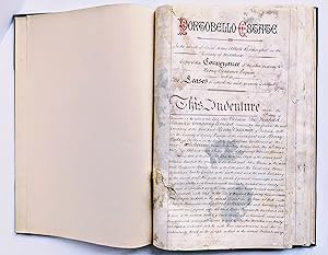
1868-1869 PORTOBELLO ROAD / PORTOBELLO ESTATE, LONDON - 62 ORIGINAL MANUSCRIPT INDENTURES with PLAT MAPS
Language: English
Publication Date: 1869
Seller: Blank Verso Books, ABAA, Mill Valley, CA, U.S.A.
Seller rating 5 out of 5 stars
First Edition Signed
Hardcover. Condition: Good. 1st Edition. SIXTY-TWO (62) ORIGINAL MANUSCRIPT INDENTURES relating to the PORTOBELLO ESTATE / PORTOBELLO ROAD AREA in NOTTING HILL, LONDON, accompanied with 62 HAND DRAWN COLOR PLAT MAPS, a CONVEYANCE and LEASE SCHEDULES. ALL are SIGNED by various notable individuals. These important real estate transactions took place in 1868 and 1869. Bound in hard covers. The main SELLER of the properties was CHARLES HENRY BLAKE and the main BUYERS were THE FREEHOLD SECURITIES COMPANY LIMITED, JOHN PARSON, and THE LAND AND HOUSE INVESTMENT SOCIETY. Sixty-one of the 62 indentures were transactions where C. H. Blake was the seller. Other individuals named in the indentures and conveyance include HENRY BESSEMER, Henry Hyde, William Honeywood, William Burchell the Younger, and other wealthy, movers and shakers of the day. Frank Richardson, Solicitor for both The Freehold Securities Company and The Land And House Investment Society, signed many of the indentures as a witness. The indentures and conveyance are bound in a book that was presumably made to hold them. Hardcovers, textured cloth covered boards with leather spine and corners, five raised spine bands, gilt title "PORTOBELLO ESTATE" on the front cover, 10x15 inches (25x38 cm), 147 pages (74 leaves). The indentures are all printed on watermarked laid paper. The first item is a long manuscript CONVEYANCE titled: "PORTOBELLO ESTATE In the parish of Saint Mary Abbott Kensington in the County of Middlesex - Copy of the CONVEYANCE of the above property to HENRY BESSEMER ESQUIRE and of the LEASES for which said property is subject". The INDENTURE that is part of the Conveyance is dated the 16th day of December 1869. It is 21 pages long and includes a FULL PAGE HAND COLORED PLAT MAP showing the properties on Golbourne (Golborne) Road between Portobello Road and Wornington Road, and a LEASE SCHEDULE that fully describes each parcel. Numerous signatures at the end of the Indenture / Conveyance. The subsequent 61 INDENTURES are between CHARLES HENRY BLAKE of Stanley Crescent, Notting Hill, in the County of Middlesex, and either JOHN PARSON, or THE FREEHOLD SECURITIES COMPANY LIMITED, or THE LAND AND HOUSE INVESTMENT SOCIETY. Nineteen are dated in 1868, the others in 1869. Each Indenture has a hand drawn plat map of the property in question, all presumably part of the Portobello Estate. Most of the indentures are 2 pages long, some longer. Condition: The covers have some old water staining / shorelining, scrapes, rubs, and general wear; the gilt title "Portobello Estate" is rubbed; else the covers are solid and doing their job well. The front and rear endpapers are recent. The bound in indentures have gray and brown stains, substantial on many of the pages, present on all the pages. Perhaps these are ink blotter stains, or offsetting from where these indentures were originally stored, or simply caused by unstable ink and colors, I do not know. The good news is that the manuscript writing is FULLY VISIBLE AND LEGIBLE beneath all the stains. The first two leaves have a 2x2.5 inch (5x7 cm) area of tearing, mostly in the blank spine gutter area but affecting some text words. The tears could be archivally repaired. The first two leaves, and a couple other pages, have a pea size hole that affects some letters. There is 1/2 inch (1 cm) of worming to the bottom blank margin of the last 3 leaves. The last leaf has a quarter (the U.S. coin) size hole in its center affecting some words. This last leaf is blank on the verso, so the affected words are only on the recto. An incredible group of important historic indentures with plat maps showing the Victorian Era property sales of the PORTOBELLO ESTATE that led to the development of the fashionable PORTOBELLO ROAD / NOTTING HILL region of London that we know today. This archive of PORTOBELLO ROAD indentures belongs in a museum, imho. Signed by Author(s).


![Seller image for Mecosta County, MI [Michigan] 2006 Land Atlas and Plat Book: featuring [city maps of] Barryton, Big Rapids, Mecosta, Morley, Remus, Stanwood for sale by Boyd Used & Rare Books](https://pictures.abebooks.com/inventory/md/md32417385065.jpg)